Final Documentation and Assessment of the
Coastal Resources Management Project
Community-Based Sites of Talise, Blongko, Bentenan and Tumbak
in the District of Minahasa, North Sulawesi Province, Indonesia
Richard B. Pollnac, Brian R. Crawford, and Chris Rotinsulu
TE-03/02-E
CRC/URI CRMP
NRM Secretariat
Ratu Plaza Building 18
thFloor
Jl. Jenderal Sudirman 9
Jakarta Selatan 10270, Indonesia
Final Documentation and Assessment of the
Coastal Resources Management Project
Community-Based Sites of Talise, Blongko, Bentenan and Tumbak
in the District of Minahasa, North Sulawesi Province, Indonesia
By
Richard B. Pollnac, Brian R. Crawford and Christovel Rotinsulu
2003
Funding for the preparation and printing of this document was provided by USAID as part of
the USAID/BAPPENAS Natural Resources Management (NRM) Program and the
USAID-CRC/URI Coastal Resources Management (CRM) Program.
Further details of Proyek Pesisir publications can be found at www.pesisir.or.id
Further details of NRM publications can be found at www.nrm.or.id
Further details of CRM publications can be found at www.crc.uri.edu
Printed in: Jakarta
Citation: Pollnac, R.B., B.R. Crawford and C. Rotinsulu. 2003. Final Documentation and
Assessment of the Coastal Resources Management Project Community-Based Sites of Talise,
Blongko, Bentenan and Tumbak in the District of Minahasa, North Sulawesi Province,
Indonesia. Technical Report TE-03/02-E. University of Rhode Island, Coastal Resources
Center, Narragansett Rhode Island, USA. pp. 104.
Credits:
Layout: B. Crawford
Table of Contents
Page
Executive Summary and Conclusions... iii
1.
Introduction...1
2.
Project Overview...3
2.1 Project Inputs, Activities and Outputs...3
2.2 Management Plan Implementation Activities Since 2000 ...4
2.2.1 Talise Project Site ...4
2.2.2 Blongko Project Site ...9
2.2.3 Bentenan Project Site...14
2.2.4 Tumbak Project Site...19
3.
Demographic, Environmental and Economic Changes
Between 2000 and 2002...24
3.1 Introduction ...24
3.2 Project Sites ...25
3.2.1 Talise...25
3.2.2 Blongko...26
3.2.3 Bentenan ...28
3.2.4 Tumbak ...31
3.3 Adjacent Non-Project Control Sites ...32
3.3.1 Airbanua...32
3.3.2 Kahuku...33
3.3.3 Sapa...34
3.3.4 Boyongpante ...36
3.3.5 Rumbia...37
3.3.6 Minanga ...38
4.
Project Impacts ...41
4.1
Project Participation and Knowledge ...41
4.1.1 Cross Community Analyses...41
4.1.2 Within Community Analyses...47
4.2 Changes in Material Style of Life ...51
4.2.1 Material Style of Life Scale ...51
4.2.2 Cross Community Analyses of Changes in Material Style of Life...52
4.2.3 Within Community Analyses of Changes in Material Style of Life...54
4.3.1 Resources Beliefs Scale ...58
4.3.2 Cross Community Analyses of Resource Beliefs ...59
4.3.3 Within Community Analyses of Resource Beliefs ...63
4.4 Changes in Perceptions of Well Being...68
4.4.1 Within Community Analyses of Changes in Well Being ...70
4.5 Perceptions of Post-Management Plan Changes ...74
4.5.1 Within Community Analyses of Perceived Changes...77
4.6 Destructive Fishing and Community Response ...82
4.6.1 Within Community Analyses of Destructive Fishing and
Community Response ...84
4.7 Summary and Conclusions………90
4.7.1 Project Participation and Knowledge………..90
4.7.2 Project Impacts……….………...91
5.
Recommendations ...95
5.1 Talise ...95
5.2 Blongko ...97
5.3 Bentenan ...98
5.4 Tumbak...99
5.5 Conclusions and General Recommendations………..100
References Cited………...102
Appendices...1-A
I.
Approved Village Ordinances in Project Anchor Sites...2-A
II.
Draft Ordinances Not Yet Approved in Project Anchor Sites ...4-A
III.
Grants for Early Implementation Actions by Village
(June 2000 - September 2002)...5-A
(November 1997 - May 2000)...7-A
IV.
List of Reports Produced on the Project Anchor Sites
(Blongko, Talise, Bentenan-Tumbak) ...9-A
V.
List of Research Assistants, National & Local Interns Working
in the Project Anchor Sites ...12-A
VI.
Activities Conducted in the Project Anchor Sites
(April 2000-August 2002) ...13-A
(October 1997 - March 2000)...21-A
VII.
Traditional Use Rights in Fisheries in Minahasa,
North Sulawesi, Indonesia ...29-A
VIII.
Project Final Evaluation Survey Form (Project Sites) ...38-A
IX.
Project Final Evaluation Survey Form (Control Sites) ...46-A
Executive Summary and Conclusions
The USAID-BAPPENAS NRM II coastal resources management project, locally known as Proyek Pesisir, established a field office in North Sulawesi Province in 1997. This is one of three provincial-level field programs contributing to the program objective to strengthen and decentralize coastal resources management in Indonesia. Four village-level field sites in the Minahasa Regency of North Sulawesi were selected in 1997 for development of models of community-based coastal resources management.
This report provides a final assessment of community-based coastal resources management activities that have been ongoing in the four villages since the Coastal Resources Management Project started in 1997. Planning activities were initiated in the villages in October 1997 with the placement of a full time extension officer in each field site. After a two-year participatory planning process and development of an issue-based profile, coastal resources management plans were approved by local government and through a village ordinance. Small-scale marine protected areas (MPAs) were also established in each of the villages at varying times and were formally approved through village ordinances. The process for establishing the community-based management plans and marine sanctuaries has been well documented. Implementation of the management plans by community management committees has been ongoing since 1999. Community committees formed after the establishment of the MPAs also manage the MPAs.
Baseline assessments were conducted in 1997 and 1998. Interim assessments of project and community activities were conducted in 200. This report provides a summary of project inputs (e.g. staffing effort, activities, community grants) and outputs (e.g. number of persons trained, reports produced, physical works constructed) as well as a review of implementation activities that have taken place since the 2000 assessment. The report also provides an assessment of demographic and socio-economic changes, as well as changes in community knowledge and perceptions that have occurred over the life of the project. Participation and gender issues are highlighted. Where appropriate, it compares project sites with similar information from adjacent control sites following a format similar to that used in the interim assessment reports. A summary of key findings are provided below.
There has been a considerable amount of progress on addressing coastal resources management problems as outlined in the village management plans and implementation activities taking place as documented in this report. We can conclude that at all sites, greater engagement and action by the communities in
identifying problems and taking actions has occurred relative to adjacent control sites and relative to pre-project activities. However, there is also a great deal of variation among the communities in the amount of effort and success levels of individual activities. For instance, while an agreement was reached in Talise concerning fishing near pearl farming areas, there is still much confusion and resentment among fishers concerning the rules and enforcement by the pearl farm. This demonstrates that while there has been progress, issues and problems are still present. We should not expect an end to all problems, and they change and evolve over time. We should also not expect that all issues and activities would always be successful. Some degree of failure should be expected. Therefore, what is important is that communities are actively working to address the issues, learning from their experience and adapting actions and strategies to improve performance over time.
In all the villages, some form of action has occurred for almost every issue highlighted in the management plans. This is a very positive sign. For instance, the management committee in Bentenan seems very active and has evolved a unique financial management system grafted from the arisan system. They have developed a detailed marine and coastal spatial use scheme to address conflicts arising from the expansion of seaweed farming. Tumbak has developed a more autonomous management committee that provides an additional example for other villages to consider. Tumbak and Bentenan have been successful at obtaining outside local government resources to finance implementation activities, especially for drinking water supply issues. All the communities have maintained marker buoys and signs for the marine sanctuaries and while some violations have occurred from time to time, the communities have been addressing the violations and
of additional block grants or outside funding for implementation activities over the last year has slowed the pace of progress.
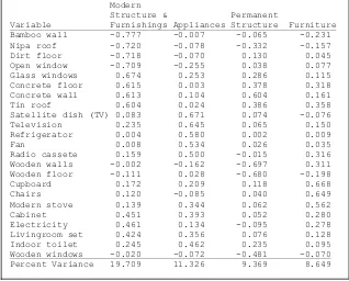
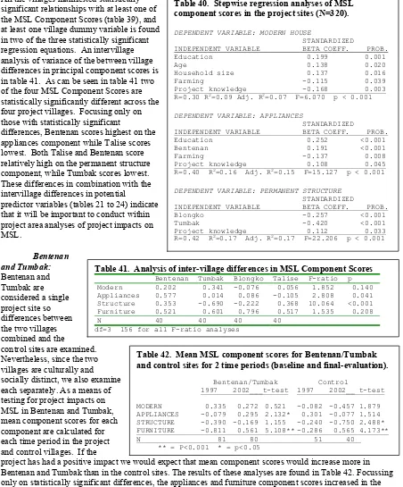
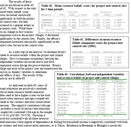
Intermediate indicators of success including the establishment of management committees and initial behavior changes demonstrating a wealth of community actions taken to address these issues are important. However, more importantly over the long run are the implications of these activities with respect to community knowledge, perceptions as well as on impacts on economic well being of the community and environmental quality of resources adjacent to the villages. The analyses of impacts make it clear that there are between project village differences in project participation and knowledge as illustrated in the figure below. In terms of
knowledge concerning an MPA ordinance in their village, almost all the respondents in Blongko and Tumbak are aware of the ordinance, and the lowest level of awareness is in Talise. This difference cannot be fully accounted for by time of establishment of the MPA because although Blongko was the earliest, the MPAs at Tumbak and Talise were established at almost the same time. The MPA at Bentenan was most recently established. There are also significant differences in interaction with field staff across the four villages. Bentenan manifests the greatest percentage of respondents who had discussed project activities with field staff, and Blongko the lowest. Project participation has the greatest variance across the various villages, with a maximum of 92 percent in Tumbak and a low of 36 percent in Blongko. With regard to specific activities, there are significant differences with respect to project organization membership. Thirty percent of respondents from Bentenan claimed membership in contrast to a little less than 20 percent in Tumbak and Talise and only 6 percent in Blongko. Significant differences also exist with respect to participation in management plan development, with a high of 39 percent in Talise and a low of 20 percent in Blongko. Part of these differences can be explained due to the length of time the extension officers have been withdrawn from the project site. In Blongko, the extension officer was withdrawn from full time assignment in 1999 and in Talise in 2000, then followed by withdrawal of the extension officer in Bentenan and Tumbak in 200. The extension officer in Blongko was withdrawn in 1999, with the extension officer in Talise withdrawn in 2000 and then followed by the extension officer in Bentenan and Tumbak. Declines in project participation indicators would be expected to decline somewhat as the project phased out of the villages. However, knowledge indicators remained high indicating retention of information transmitted as part of the participation process, which is one of the results expected. In addition, percentages of individuals with knowledge was higher than those participating, indicating a diffusion of information within the community from those who participated to those that had not.
Several composite indices of project participation and knowledge also varied across the project villages. With regard to the participation index, Bentenan had the highest mean score and Blongko the lowest. In contrast, Blongko scored highest on the project knowledge index, and Talise scored lowest. Talise also scored lowest on the MPA knowledge index while Tumbak manifested the highest average score. These
Project Knowledge and Participation
0 20 40 60 80 100 120
Bentenan Tumbak Blongko Talise
Know MPA ordinance
Project participant
Interact with staff
Plan participant
aspects of project participation and knowledge that varied significantly across the villages are illustrated in figure below.
The analysis of factors influencing participation identified education and gender as being the most significant predictors of project participation. Years of formal education manifested the strongest correlations with the project knowledge and participation indices. This was expected since formal education has long been noted as a variable variously influencing behavior, with the more highly educated being more likely to participate in new activities and acquire new information. The division of labor by gender in many societies impacts participation as well. For example, in societies where women’s work is strictly defined and limited, if the project activities fall outside these limits, female participation may be minimal or absent. Religion may have an influence on participation in several ways. In most Islamic societies adult females tend to avoid interaction with males outside their family and tend to have strictly defined roles, including allowable activities. This may influence their participation in project activities, as we hypothesized for our findings in Bentenan and Tumbak in 2000.
Identification of the gender differences in participation in the mid-term evaluation resulted in increased efforts to involve more women in project activities. Our success in this endeavor is illustrated in the following figure, which indicates that the relative differences in female and male participation decreased between 2000 and 2002.
One question for evaluation concerns whether or not project activities have improved the coastal
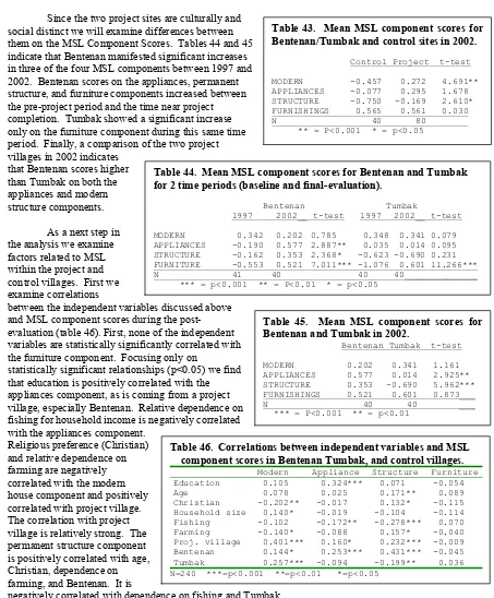
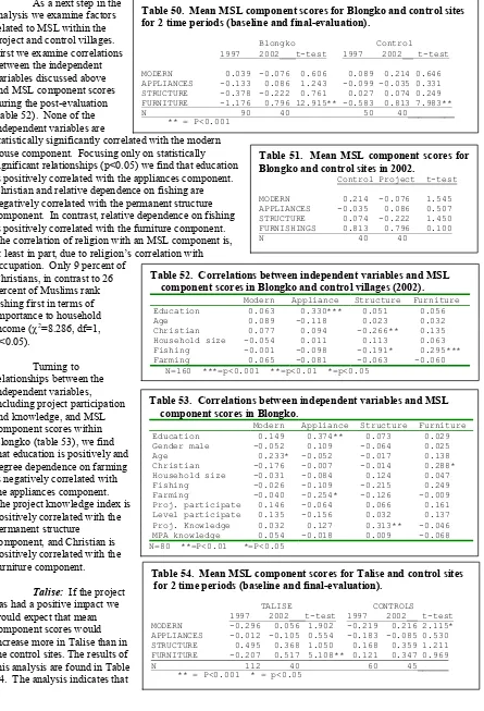
livelihood (both monetary and non-monetary income). In the absence of reliable income data, material style of life is used as an indicator of level of livelihood; thus, changes in this indicator are assumed to reflect parallel changes in livelihood. Analyses of material style of life changes over the life of the project indicates that, overall, the project villages manifested an increase in household appliances and furniture. While the control villages also manifested increases in furniture, their increase was not as great. These changes are illustrated in the figure below. This suggests the project has had some impact on overall quality of life and economic well being of residents in the project communities.
With respect to impact indicators, success and sustainability of a project are based in large part on participants’ reactions to the project. In turn, these reactions are based on user perceptions of impacts, which are not always in accord with objective, quantifiable evidence. Hence, if there is an interest in understanding success and sustainability of a CRM project, it is essential to understand perceptions of the present and possible future impacts of the project. Perceptions of impacts may explain some of the variance in long-term, as well as short-term, project success. Impacts of interest with respect to Proyek Pesisir are the following:
• Overall family well-being. • Control over coastal resources. • Ability to influence community affairs.
• Amount of traditionally harvested fish in the sea. • Coastal resource health.
• Compliance with fishery regulations. • Enforcement of fishing regulations. • Prosecution of violators of the MPA.
• Support for the MPA from the local government.
Analyses of differences between control and project sites with respect to these nine indicators indicated statistically significant differences for two as illustrated in the figure below. Residents of project villages perceived larger positive changes in amount of target fish and environmental condition—two important goals of
Material style of life component scores
-0.8 -0.6 -0.4 -0.2 0 0.2 0.4 0.6 0.8
Project 1997 Project 2002 Control 1997 Control 2002
Appliances Furniture
Perceived changes in environment
0 0.5 1 1.5 2
Amount of target fish Environmental condition
coastal zone management projects. In addition, it is significant to note that within the project villages, project and MPA knowledge are significantly correlated with an indicator reflecting increasing community control of coastal resources. This indicator is a scale composed of a weighted sum of perceived changes in control over coastal resources, ability to influence community affairs, compliance with fishery regulations, enforcement of fishing regulations, prosecution of violators of the MPA, and support for the MPA from the local government. This indicates that villagers having knowledge of project activities perceive that they have increasing control over their resources, an important, first step in community based resource management.
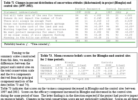
It is also expected that coastal resource management project activities would have impact on community members’ beliefs about factors that impact the quality of the coastal environment. Analyses conducted clearly indicate project impacts in the expected direction as illustrated in the figure below. While the total conservation beliefs score increased in both the project and control sites, it increased to a greater degree in the project sites, as would be expected if the project had the desired impacts. Hence project villages perceive greater benefits to collective community action for resources management and conservation compared to the control sites.
The analysis of individual characteristics related to resource beliefs confirms the finding that Proyek Pesisir had a positive influence on villagers’ environmental knowledge. While years of formal education manifest the strongest correlations with the conservation beliefs scale, the project and MPA knowledge scales are also significantly correlated with environmental knowledge. There is, however, significant inter-community variation with respect to the total conservation beliefs scale with Bentenan residents scoring highest and Talise scoring lowest. This inter-community variation might be explained by the fact that Talise residents in the sample manifest the lowest level of formal education, while those from Bentenan manifest the highest, and education is strongly related to scores on the conservation and other resource beliefs scales.
Finally, we would expect that Proyek Pesisir activities would influence villagers’ response to illegal fishing activities. Analyses presented in indicate that those in project villages say that they would take harsher actions against violators than those in the control villages, supporting our expectations. It is interesting to note that across all villages (both project and control), males, those who believe that humans can have an impact on marine resources and those who believe that their resources and quality of life have improved over the past few years are more likely to report that they would take more stringent action against illegal fishers. Within the project villages, as we would hope, knowledge of project activities also contributes to a more negative response to illegal fishing.
Overall, the analyses of the survey data clearly indicate that although there is a fair amount of inter-project village variation with respect to inter-project impacts, the inter-project has had significant positive impacts in the project communities. Comparisons with control villages allow one to attribute the changes to project activities. Impacts include increased project participation, positive changes in material well-being, perceptions of
improvement in the coastal environment, and increases in environmental knowledge—all impacts that indicate that the coastal management processes initiated will be sustained.
M ean to tal con servation b eliefs sco res
5.2 5.3 5.4 5.5 5.6 5.7 5.8 5.9 6 6.1
Continuing support needs to be provided to these communities by local institutions to enhance the probably of sustained coastal resources management efforts. While a provincial and district coastal law have been enacted that legitimize and encourage community-based management, local institutions have not yet developed program strategies and budgets to provide continuing support to these villages as well as other coastal communities. This has been demonstrated to be a critical success factor for sustainability of
community-based efforts in the Philippines. As the project has now phased out of these project sites, working to develop local community support systems and linkages with NGOs, local universities and government agencies such as Dinas Perikanan dan Kelautan should be priorities.
1. INTRODUCTION
The USAID-BAPPENAS NRM II coastal resources management project, locally known as Proyek Pesisir, established a field office in North Sulawesi Province in 1997. This is one of three provincial-level field programs contributing to the program objective to strengthen and decentralize coastal resources management in Indonesia. Four village-level field sites in the Minahasa Regency of North Sulawesi (see Figure 1) were selected in 1997 for development of models of community-based coastal resources management (Tim Kerja Proyek Pesisir, 1997). Subsequently,
socio-economic and environmental baseline surveys and technical studies were carried out at each site (Pollnac et al. 1997a, 1997b; Kusen et al. 1997; 1999a; 1999b; Mantjoro, 1997a, 1997b; Kasmidi, 1998; Kussoy, 1999; Crawford et al. 1999; Lee and Kussoy, 1999,). Surveys were also conducted in villages adjacent to project sites. These villages are being used as control sites (Pollnac et al. 1998, Fakultas activities that have been ongoing in the four villages since the Coastal Resources Management Project started in 1997. Planning activities were initiated in the villages in October 1997 with the placement of a full time extension officer in each field site. After a two-year participatory planning process and
development of an issue-based profile, coastal resources management plans were approved by local government and through a village ordinance (Tankilisan et. al. 1999, Kasmidi et. al. 1999, Dimpudus et. al. 1999). Small-scale marine protected areas (MPAs) were also established in each of the villages at varying times and were formally approved through village ordinances. The process for establishing the community-based management plans and marine sanctuaries has been well documented (Crawford et al. 1998, Tulungen et al. 2000) and therefore will not be repeated here. Implementation of the management plans by community management committees has been ongoing since 1999. Community committees formed after the establishment of the MPAs also manage the MPAs.
Baseline assessments were conducted in 1997 and 1998 (see Appendix IV). Interim assessments of project and community activities were conducted in 2000 (Crawford et al. 2000a, 2000b, Sukmara et al. 2001, Pollnac et al. 2002). This report provides a summary of project inputs (e.g. staffing effort, activities,
community grants) and outputs (e.g. number of persons trained, reports produced, physical works constructed) as well as a review of implementation activities that have taken place since the 2000 assessment. The report also provides an assessment of demographic and socio-economic changes, as well as changes in community knowledge and perceptions that have occurred over the life of the project. Participation and gender issues are highlighted. Where appropriate, it compares project sites with similar information from adjacent control sites following a format similar to that used in the interim assessment reports. Methodology for the baseline and subsequent surveys and data analysis are contained in Pollnac and Crawford (2000).
2. PROJECT OVERVIEW
2.1 Project Inputs, Activities and Outputs
The four anchor field sites of Blongko, Talise, Bentenan and Tumbak have benefited from a continuing series of project interventions starting in 1997 and ending with closing ceremonies held in each village in December of 2002. The interim assessment reports (Crawford et. al. 2000a, 2000b, Sukmara et. al. 2001, Pollnac et. al. 2002) documented and summarized those interventions through May 2000. During this period which covered the management planning process and initial plan implementation activities, field extension officers were assigned to each village full-time, except for Blongko where the full time extension agent was withdrawn in 1999. Project activities continued in these communities through 2002. Project inputs, activities and resulting outputs that occurred during this six year period are listed in Appendices I through VII and are summarized below. Maps of the Marine Protected Areas (Marine Sanctuary) established in each village are contained in Appendix X along with maps of each project and control village.
A total of 15 village ordinances pertaining to coastal resources management were developed and approved (Appendix I). These ordinances formalized adoption of coastal resources management and development plans, village marine sanctuaries, and management committees as well as addressed specific management issues within each community. As of October 2002, eight additional ordinances were in draft form, awaiting final approval by the communities and village government (Appendix II).
During the period of November 1997 to May 2000, a total of RP 115,000,000 in project funds and RP 50,500,000 in local government funds were provided to these four communities as grants for implementation activities (Appendix III). During the period of June 2000 to September 2002, an additional RP 140,000,000 was provided to these villages by the project for implementation activities. In addition, some of the
communities have secured additional funds for plan implementation projects. All of these implementation actions are described in more detail in the appropriate sections below.
A large number of reports were produced on these sites (Appendix IV). This included participatory profiles and management plans, environmental and socio-economic baselines, interim assessments, as well as consultant, internship and training reports. A total of 35 reports were produced that provide a wealth of documentation on these communities including environmental and socioeconomic conditions and changes, as well as the types of technical studies, technical assistance and training that were provided to support
management planning, plan implementation and community capacity building.
Interns and research assistants also contributed to the overall effort (Appendix V). Interns that assisted field extension officers with various planning and training activities and/or implementation activities
contributed a total of 564 person days of effort. Research assistants that contributed to the interim assessments totaled 347 person days in the villages. On average, interns and research assistants in these sites contributed approximately 200 person days of effort.
At each site dozens of meetings, environmental education activities, training events and presentations were implemented (Appendix VI). The total number of participants who attended these events in Blongko was 4,346 persons over the six-year period (35 percent female). In Bentenan and Tumbak the total number of participants was 8,863 persons (36 percent female). In Talise the total number of participants was 4261 persons (45 percent female). In Talise, there was a significant decrease in female participation after May 2000. This may be a result of withdrawal of the female extension officer in 2000, and continuing activities in the site were mainly coordinated by the male field assistant. There were negligible differences between male and female participation after the extension officers were withdrawn from Blongko, Bentenan and Tumbak. This may be due to the use of female field assistants in Blongko and Bentenan, and both a male and female field assistants in Tumbak. Hence it would seem that gender balance among field assistants and extension officers may help increase female participation rates.
and is doing with respect to implementation actions to address the multifaceted socio-economic and
environmental problems and opportunities within their respective village. These are behavioral indicators of what the community is now doing as a result of project interventions. However, the more important question that needs to be addressed in this assessment is what was the result of both the project and community
investments. Changes in impact indicators with respect to individual knowledge, quality of life, well-being, and perceptions are detailed in a later section of this report.
2.2 Management Plan Implementation Activities Since 2000
The planning process and initial implementation activities at each field site were evaluated in 2000 (Crawford et. al. 2000a, 2000b, Sukmara et. al. 2001, Pollnac et. al. 2002). This report builds on the previous assessments and describes activities that have been implemented by the community since 2000 or are ongoing. Information on each activity was obtained from key informant interviews of project staff, field assistants, village officials and individuals directly involved with implementation activities. In addition, direct observations were made of the tangible manifestations of the activities (e.g. constructed dike, planted trees). Recommendations are provided in the last section of this report for local government, community and/or action by project staff prior to completion of the project.
2.2.1 Talise Project Site
The Talise Coastal Resources Development and Management Plan was formally approved in 1999 by village ordinance after a two-year participatory planning process. The plan addresses twelve coastal resources management issues where specific objectives were set to achieve a vision of sustainable community
development over a 30-year period. A number of activities are proposed in the plan to address each issue. In addition, the plan calls for the establishment of a management committee and a marine sanctuary committee to carry out implementation under the supervision of village government.
The major components of the management plan are: 1. Land Tenure
2. Resolving Sea Use Conflicts
3. Sustainable Forestry Management and Protection of Wildlife 4. Prevention of Coastal Erosion and Flooding
5. Drinking Water Supply
6. Improving Environmental Sanitation 7. Human Resources Development 8. Improving Farming Productivity
9. Management of Mangroves and Coral Reefs 10. Developing Eco-Tourism
11. Strengthening Community Awareness Concerning Natural Resources 12. Establishment of a Management Plan Implementation Committee 13. Monitoring and Evaluation
Descriptions of activities undertaken by the community that are related to each of the above mentioned plan components are provided below.
Land Tenure
nothing has happened. Residents stated that the Hukum Tua has to come to Kinabohutan in order to restart the process. Each household must contribute 100,000 RP to the process but they have not yet done this since they are waiting for the process to start again. Approximately 200 families are involved. The Kepala Jaga said that families against the MPA are not involved. The Kepala Jaga reports that "it is hard to find the Hukum Tua" because he no longer lives in the village.
Resolving Sea Use Conflicts (Talise declaration/community-pearl farm agreement)
In 2000 pearl farm representatives met with three representatives each from Kinabohutan, Jaga 1 and Jaga 2 to discuss the sea use conflicts between village fishers and the pearl farm. This resulted in a letter of agreement concerning fishing activities adjacent to the pearl farm area. Net fishing is not allowed within 75 meters of the outer boundary of the pearl farm. Hook and line fishing is allowed within the boundary, but boats are not allowed to tie-up to the pearl farm buoys. The issue of spear fishers never came up. This is a huge concession by the pearl farm whereas before fishers were not allowed near the farmed area, now they have access to a large area that actually attracts fish with its rafts & buoys. A later amendment to the rules allows
funai bait fishing around the pier during non-work hours. Gleaners are also allowed under the pier. When the agreement first went into effect, some fishers from Kinabohutan violated the rules, but these violations have ceased.
There is, however a great deal of confusion among the fisher population with respect to application of this declaration. Some report that they are unaware of its existence. For example a group of several fishers in Jaga 1 say that they can fish only during the day because some pearl oysters were reported missing and pearls will be harvested soon. At night they have to be at least 50M from a raft. Another Jaga 1 fisher reported that villagers who work at the pearl farm told him that fishers are not allowed in the area.
Fishers in Kinabohutan seem especially confused. They say that they must report to authorities before they fish, but when they begin fishing, the guards become aggressive and chase them by shooting in the air. A purse seiner from Kinabohutan got too close to the boundary and was aggressively chased away. This incident resulted in some community members threatening to burn down the pearl farm. The pearl farm management reportedly called in police to guard their area while community leaders cooled down the population. Net fishers asked what they should do if their nets, along with the fish, start to drift into the buffer zone around the pearl farm rafts. They were told that they have to rapidly lift their nets, which they claim is impossible.
Even the hook and line fishers are confused. They say that they ask permission and follow the rules, but are still aggressively chased by the guards. Some have blamed this aggressive behavior on pearl farm employees (most from Jaga 1 and 2), whom they claim encourage the guards to chase them. Some attribute the problem to the lack of information transfer at guard personnel changes. It is alleged that when the new guards come on duty they do not know who has permission and who does not. One ex-official goes so far as to claim that his signature was forged on the agreement with the pearl farm.
Boat Engine (katinting) revolving fund
The project started with five motors, and three were added by the revolving fund as originally planned. The group is still obligated to provide two more. The project is still ongoing, and payments are going into the revolving fund. A second recipient group was formed soon after the first. When the rotating fund resulted in three new motors, they went to 6 members of the second group. Bad weather has reduced the ability of two of the earlier motor recipients to effect payback.
Sustainable Forestry Management and Protection of Wildlife
trees, and the entire area is inter-planted with cassava. Group members sell the cassava harvest in the community. They have seedlings to replace trees that died, but they are waiting for the drought to end.
The Kepala Jaga of Jaga 1 has been keeping records of turtle hatchlings on the beach in front of his house, in a new settlement area to the north of the Jaga 1 main settlement area. He has reported that over 7000 have hatched in the last year. He helps hatchlings by keeping predators away from nests. He has also been planting trees in the hills above his house.
Prevention of Coastal Erosion and Flooding
Sand Mining Ordinance: An ordinance was passed that regulates sand mining in the village. Signs are posted in both Jaga 1and Jaga 2 that indicate locations where mining is allowed and prohibited. Sand mining in areas in front of the village has been limited to small amounts by villagers only. The pearl farm is restricted to mining sand for their anchors from a special area.
Flood Control Dike on Kinabohutan: Construction of the dike was completed. There has been no high tide flooding since it was finished, but very high waves sometimes splash over. Banana plants that are growing in an area previously flooded and too saline for that crop provide evidence of its effectiveness.
Drinking Water Supply
Water System: The new Hukum Tua went to the water authority in Tondano and requested help. He was given a bundle of pipes that were never used until the gardening group requested some for irrigation. Then several families requested some for bringing water to their homes. Drinking water is piped from a box (not completely closed) at the spring to a few areas in the village. Pipes are simply laid on the surface.
Watershed Greening: As part of the block grant, money was provided for plantings around the wells and springs. Reportedly, the trees weren't cared for and less than 20 percent survived. The village secretary reported that in Jaga 1 there was planting of trees and other plants around the watershed. An estimated 40% survived the drought and heat.
Improving Environmental Sanitation
The senior extension officer reported that several beach clean-ups have been organized over the past several years. In addition, Tambun (Jaga 1) reportedly conducts periodic clean-ups. However, on several occasions, dumping of household garbage on the beach (organics and non-biodegradable plastics) was observed during the field survey work by the survey team in the area near the team’s residence in Tambun.
Human Resources Development
Retention of teachers at the junior high school is problematic. Six teachers have been lost and not replaced. The school is planting bananas and other crops on the premises in order to raise funds for building maintenance.
Improving Farming Productivity
Plantings included cucumber, popare, long green beans, cai sin, chili peppers, tomatoes, spinach (bayam), kankung (dry kankung), and eggplant. Fruit tree seedlings were rooted from existing fruit trees in Talise. Types included oranges, limes, starfruit, and guava. The fruit tree rooting and planting was restricted to Jaga 2. Originally, the vegetable gardening was conducted in a communal garden in Jaga 2. This failed, and participants developed private gardens in the hillside farms or near their houses. Fruit trees were planted near the group members' private dwellings. First harvests of vegetables were sold in Talise and Gangga. The 2002 drought resulted in failure of the vegetable crop, but the fruit trees are being maintained by watering.
In Jaga 1, the vegetable garden group began with 15 female members split into 5 groups of 3. Soon after they started to till the soil 10 women left the group because they felt that they didn't have the required time due to other responsibilities. Since then, another woman dropped-out, reducing the group to 4. The Jaga 1 group has not planted any fruit trees.
In Jaga 1 there are group gardens in two areas: a small plot near the Hukum Tua's office and a 3/4 hectare plot close to the spring. They have had several harvests, providing additional vegetables for the home as well as income received from selling the crops in markets in Kinabohutan, Gangga 2, Kahuku, and Libas. People from Kinabohutan stopped buying kankung, however, because they heard that pigs frequented the area where it was cultivated. The 2002 drought severely limited activities, even though they have extended water pipes to the plot near the Kepala Jaga's office. The biggest problem they have is getting the crop to other markets due to lack of transportation.
Management of Mangroves and Coral Reefs
Informal Mangrove/Beach Sanctuary: An informal mangrove and beach sanctuary was declared by the Hukum Tua on the beach side of the information center in Jaga 2. It is called the Tambun Beautiful Beach Area. Community leaders in Kinabohutan proposed a similar declaration, but residents rejected the idea.
Mangrove Replanting: Mangrove replanting was done in Jaga 1 and 2 and Kinabohutan. In
Kinabohutan most of the year 2000 plantings died. In 2000 they used the polybag procedure. They then tried to use a pipe (PVC) around the plant, and this also failed. In 2001 they poked a hole in the sand and stuck 3 seedlings in. They figured that at least one would survive. The Kepala Jaga and his brother are caring for the replanted area. They wipe off fungus and snails, and attribute the success to the new planting procedure as well as the continuing care of the growing plants. Stakes mark the planted area so that the seedlings are not run over by boats when submerged at high tide. An area 60 by 5 meters seems to be growing well. They still have a nursery area, and they are obtaining some seedlings from both Talise and Gangga. The Kepala Jaga for Jaga 2 alleged that the earlier plantings failed in Kinabohutan because the people did not really care. In Kinabohutan only 2 families continue to plant mangrove. In Jaga 1 and 2, some replanted mangrove survived to the south of Jaga 1 and behind the mangroves in Jaga 2. Seedlings planted by the Kepala Jaga north of Jaga 1 are doing well. Mangrove replanting in front of the school in Jaga 2 reportedly failed due to boats running over the area. However, this is also a more exposed coastline. Plantings near the MPA in Jaga 1 survived. Replanting continues, but seedling mortality remains high.
Marine Protected Areas: The MPA established off Jaga 1 still has marker buoys but there allegedly have been many violations by Kinabohutan residents fishing for cuttlefish and other small species. Residents of Jaga 1 also occasionally fish in the area. Early violations by outsiders (Lembe and Airbanua) were reported, but they have ceased. There is reportedly a lack of surveillance.
observed on many occasions during the field visit. This was usually boats carrying people between Kinabohutan and Jaga 1. The shortest route is through the sanctuary.
Committee members conduct surveillance of the MPA. The committee received a block grant from BAPPEDA for two katinting that MPA group members use for fishing. They are required to patrol the MPA while on their way fishing. This is done at least once daily. When someone is apprehended fishing in the MPA, they are required to write a letter of apology and pay a 25,000 RP fine. These fines go into a fund, 50 percent of which goes to MPA maintenance, 20 percent to the MPA committee as a fee for services provided, and 30% goes to the village. In the past year they collected 225,000 RP from fines.
The MPA also earned 800,000 RP over the past year from fees and "donations". This money is distributed in the same manner as that collected from fines. These fees were collected from people who wanted to dive in the MPA for various reasons--some to study the MPA and some tourists. The set fee is 10,000 RP, but people often donate a little more. The MPA committee hopes to stimulate more tourism with the development of a brochure for tourism.
An MPA committee was formed in Kinabohutan, an area selected, and a floating guardhouse built. A number of community members (one source said 10 families, another said 50-60 agitators), however, strongly opposed its establishment. They said that enough area had been removed from their fishing grounds by the pearl farm and the Jaga 1 MPA. They also objected to the punishment of community members for violating the Jaga 1 MPA; e.g., the slapping of a violator by the Hukum Tua and the fining of a fisher who was unaware of the rules. They said that they did not want to be involved in an institution that dealt out such harsh
punishments. Finally, they were afraid that they would be subject to offensive behavior by visiting tourists (e.g., naked sunbathing and swimming).
Developing Ecotourism
A youth group composed of both males and females was funded for cross-visits to Bunaken and Tangkoko national parks. The group leader said that the cross visits to Tangkoko were very beneficial. They returned and identified three wildlife sites each in Jagas 1 and 2. They also identified one in Kinabohutan. They put up signs in the sites in an attempt to preserve them for future ecotourism. Residents reportedly removed the sign in Kinabohutan, but the others reportedly remain. A visit to Kinabohutan indicated that this information is inaccurate. Signs are still up, and the partial tearing of some of the thin metal signs was attributed to wind.
The group from Jaga 1 was composed of four people and was formed in 2000. They identified three (actually two, with one a dual purpose site) sites. Rumah Angin for tarsier and birds and the bat caves at the northern end of the island. Signs have been erected at all sites.
The group from Jaga 2 consisted of 18 members. 13 went to Tangkoko, one to Bunaken and two to Togian. Upon return, they selected three areas for ecotourism based on forest cover and wildlife: Sawang, which has deer, tarsier, and macaque; Kobong Tinggi, with macaque, couscous, and birds; and Selong, which has birds, snakes, lizards, macaque, tarsier, squirrel (tupai), and deer. Kobong Tinggi is located 1960M from Tambun (Jaga 2), and Selong is 700M further. Sawang is 300-400 meters from Kobong Tinggi on a different path. A path to Selong is also accessible by boat from an area south of Airbanua. There are signboards at Kobong Tinggi and at the start of the path to Selong just above the settlement area. The group has made a proposal to the forestry office to obtain tree seeds for planting and have informally proposed that the forestry office declare the areas as protected.
Strengthening Community Awareness Concerning Natural Resources
maintenance program for the building. Another complaint is that there are not enough books in the center's collection. However, junior high school teachers use the books that are there in their classes.
Management Committee
The coastal resources management committee still meets but not every 3 months as originally planned. In October there will be a meeting to elect new officers as well as new members to replace inactive participants. Yearly, coastal management plan activities are integrated into the village development plan.
Monitoring and Evaluation
Most monitoring and evaluation is either facilitated by or conducted by the project. For instance, the project facilitated a workshop on the evaluation of block grants in 2000 (CRMP Sulut 2001). Meetings were also facilitated by the project in July 2002 to undertake a review of management plan and marine sanctuary implementation. The meetings started with a self-assessment by the management committees followed by public review. The results of these meetings are contained in a technical report (Dimpudus 2002). The marine sanctuary committee does not conduct any systematic coral reef or fish abundance surveys in the marine sanctuary. On occasion, they do observe changes in a very qualitative manner with respect to general fish abundance and changes in key species composition. For instance, the head of the sanctuary management committee reported an increase in the abundance of squid and occasional presence of jacks. He also indicated that fish in the sanctuary tend to be less skittish around humans.
2.2.2 Blongko Project Site
The Blongko Marine Protected Area was established by village ordinance in 1998. This was followed by the development of a Marine Sanctuary Management and Coastal Resources Development Plan that was formally approved in 1999 by village ordinance after a two-year participatory planning process. The plan addresses nine general coastal resources management issue areas where specific objectives were set to achieve a vision of sustainable community development over a 15-year period. A number of activities are proposed in the plan to address each issue. In addition, the plan calls for the establishment of a management committee and a marine sanctuary committee to carry out implementation under the supervision of village government.
The major components of the Blongko management plan are: 1. Management of the marine sanctuary
2. Protection and rehabilitation of coral reef, mangroves, seagrasses 3. Increasing community incomes
4. Raising awareness of community concerning environmental protection 5. Community health and sanitation
6. Preventing coastal erosion and stream flooding 7. Improving community livelihood/production
8. Reducing erosion/sedimentation from land and farm areas
9. Implementation of the management plan by the village Coastal Management Board.
Descriptions of activities undertaken by the community that are related to each of the above mentioned plan components are provided below.
Marine Sanctuary Management
Surveillance and Enforcement: The Surveillance and Monitoring Group (SMG) has not been very active since it was formed according to its leader. He suggests that the inactivity might be the consequence of two factors: lack of free time and lack of pay for effort. The group is scheduled to change its composition after project phase out and closing ceremony (“graduation”), and this may influence activity levels. The old bamboo and wood information center located on the beach front in Jaga 1 is now reportedly used as the guard post. The building is in good condition and has a sign posted on the outside indicating it is a surveillance post. Supplies for marker buoys are also stored in one of the small rooms in the building.
The group’s leader says that they regularly watch the area, not by boat but by walking along the coast. Sometimes someone may borrow a boat to go around the area. If a violation is observed, and if they are close, they may yell at the person. In some cases they hurry to the Hukum Tua's house and use the public address system to tell the violator to cease his/her activity. If they observe other illegal fishing activity they report it to the Hukum Tua who reports it to the Kecamatan. The leader of the SMG said that since formation of the MPA there has been no dynamite fishing observed in Blongko waters.
Since 2000 there have been between approximately 12 violations of the sanctuary. Very minor violators (e.g., walking on the reef flat) are simply warned. Harvesting violations (e.g. fishing, gleaning) are punished by requiring the violator to write a letter of apology and promise never to do it again. Only one local violator (a spear fisher) was referred to the Camat for punishment because he threatened the head of the SMG. There is some concern because some community members think that the MPA will be open to fishing after the graduation.
Monitoring: The head of the SMG reported that they had done no manta tow monitoring until recently when the project conducted another training program in December 2002. Prior to this, all monitoring was done on an ad hoc basis, such as when repairing a buoy or accompanying visitors to the MPA. Seagrass monitoring has also been conducted (see section below on rehabilitation of habitats).
Management Committee: The head of the MPA Management Committee (MPAMC) reported that they have not had regular meetings until they recently began planning for the graduation ceremony. Up until then, they would simply meet informally with the Surveillance and Monitoring Group (SMG) to determine the status of the marker buoys, violations, etc. In their most recent meeting, they talked about revitalizing sections to work more effectively together. In terms of reorganization activities, the public relations group has become a part of the environmental education panel of the Environmental Management and Village Development Board. The MPAMC has two remaining sections: SMG and the fund raising group.
Income and Expenditures: There has been no formal agreement concerning the allocation of income from the MPA. There are plans to prepare a letter of agreement allocating 50 percent to community
development and the other half to MPA needs (e.g. replacement of buoys, surveillance, etc.). According to MPA Committee records, total income since 1999 was RP. 10,592,550. It is important to note that the majority of the income was from two awards: one from the COREMAP Project in Jakarta (7.5 million RP) and one from the Minister of Marine Affairs (National Coastal Award for a Community -- 1 million RP) presented at the 2000 National Coastal Conference held in Makassar. Other sources of revenue have come from donations provided by study tour visitors to Blongko. Of this total 9,559,900 had been spent as of 7 October 2002. About 300,000 was spent to purchase rope for anchoring a marker buoy since the 7 October accounting, leaving about RP. 700,000 in the account.
Some examples of expenditures include about 380 thousand Rupiah spent to install electricity in the information center, 2.5 million for materials to finish the water supply system (as of yet not completed), a one million Rupiah loan to the village government for a satellite phone, and 1.5 million Rupiah for purchase of land occupied by the old information center. They plan to renovate the old information center and use it for
meetings and a place for visitors to change before diving or snorkeling in the MPA. Protection and Rehabilitation of Marine Resources
took place in July 2002, and UNSRAT personnel conducted only one monitoring session with the community group members. A formal community sea grass monitoring group has not yet been formed, but there are plans to include them in the MPA surveillance and monitoring group (MPA-SMG). Community members have not yet conducted monitoring on their own.
Mangrove Replanting: Some mangroves have been planted at the area of the river diversion dike, and they are growing. Perhaps more important, the Dinas Perikanan sponsored a mangrove replanting project in 2001. A mangrove replanting group (MRG) of ten were formed and asked to collect mangrove from the wild for replanting. About 30 community members joined the MRG during seedling collection and replanting. They were paid 500Rp for each tree replanted. They allegedly received no instructions from Dinas Perikanan, and all the replanted mangroves subsequently died. One informant said that the only benefit was the money received by community members for the replanting. There are no signs of replanted mangroves in the replanted areas— not even a dead branch.
Subsequent to this failure, the MRG did not disband, but tried to figure out what happened. Since most of the fishers in Blongko are also accomplished farmers, the group leader suggested trying to grow the trees from seed rather than digging up the wild ones. They made a nursery and experimented with polybag and non-bag planting in muddy areas. Through experimentation they selected the one kg. sugar non-bag as the ideal non-bag. They also found that seeds spread in muddy areas could be easily transplanted at an early age. Direct seeding in the area to be replanted is also practiced. Observed replantings seem to be thriving, and the evaluators were impressed by the fact that the MRG is observing replantings from the various techniques (e.g., polybag, seedlings from seeds planted in muddy areas, direct seeding, etc.) to determine which is the most effective. The MSG understands the reasons for replanting and remains committed to the process even though they are no longer reimbursed for their work. They have developed a scientific research design to select the approach most effective in their locale. They have also identified non-botanical reasons for failure (e.g., plantings in areas of heavy boat traffic will not succeed, etc.) and are avoiding these factors in present replantings. The Blongko MRG should be encouraged and observed to determine if outside change agents can stimulate this type of “bottom-up” research activity elsewhere rather than simply “teaching” community members techniques which are achieving only limited success elsewhere.
Artificial Reefs: The Dinas Perikanan (Fisheries Office) also had an artificial reef construction and deployment component along with the 2001 mangrove replanting project discussed above. It is reported that seven units of artificial reef have been deployed, with units composed of 6 truck tires tied together and others from wrecked vehicles. There is some controversy concerning how many artificial reefs actually remain in the area—some report that they have all been destroyed by weather and others say they all remain. At least one tire unit has been destroyed by wave action as residents’ report they did clean up some tires that washed ashore. Three tire units were observed during a dive in the area where the artificial reefs were placed. There was very little coral growing on the tires that were covered in sediment and algae. A few small colonies were growing on the lines used to tie the modules together. The three tire reefs observed were placed in very shallow waters of approximately 5 meters depth or less. They were also on top of a splendid natural living reef, not in deeper water on the sand/mud bottom beyond the fringing reef base. One loose tire was observed approximately 20 meters from the reef footing and located on the sandy bottom area. No car modules were seen during the dive.
Increasing Community Incomes
T-shirt Printing: A group of 12 was formed and trained in the process of preparing and printing designs on t-shirts. Six dropped out but the remaining six have sold a first printing of t-shirts to visitors to the MPA (gross 590,000Rp, net 200,000Rp). The group plans to acquire workspace in the new information center. They also have plans to design and print 100 more t-shirts to be sold at the Proyek Pesisir graduation ceremony.
Raising Awareness of Community Concerning Environmental Protection
Information Center: A new information center has been constructed in Blongko. It is located near the Hukum Tua’s office, an elementary school and the soccer field, a more central and highly visited area. Hence, it now has more visibility than in the past. It is not yet officially opened (October 2002), but a visit indicated 25 educational and/or informative posters and photographs and two framed awards posted on the walls and
signboards. There is a bookcase with a small stack of unorganized books and reports on one shelf, a small room (approximately 3.5m by 3.5m) that may be used for the T-shirt printing workshop, and a toilet. Graphs
illustrating differences between resources inside and outside the MPA, which were posted in the old information center, are absent.
Environmental Education Activities: The MPA signboards and the information center provide environmental education to community members who visit the center or view the signboards. In 2000 there was an environmental conservation drawing contest for school children coordinated by the Public Education Section under the MPA Management committee. This section is now part of the Village Coastal Resource Management and Development Board, with the same members.
A temporary group of three was formed for a study tour to the Togian Islands. The purpose of this trip was to share Blongko experience with a project supported by Conservation International. There were no follow-up activities after the trip was completed.
The Environmental Sanitation Group (ESG) within the Village Coastal Resource Management and Development Board is coordinating a beach cleanup among elementary school children. They plan to have a competition between the five Jaga (sub-villages) to determine which has the cleanest beach. This competition will be part of the Proyek Pesisir graduation ceremony. The ESG is also reported as conducting environmental sanitation education in the village.
Community Health and Sanitation
Water Supply: The water supply project was a part of a World Bank project. Community members were supposed to pay RP. 8,000 each and the Project contributed this amount. The water tank is still incomplete and water is flowing only to Jaga 1, 2 and part of 3 and 4. The MPA Management Committee provided 2.5 million Rupiah in materials to finish the project. The community wants the MPA Management Committee to take over the completion of the project, but the committee is reluctant, saying that the village government should do it because they can order people to work. Work groups have been formed in each Jaga, but the village government has not ordered the work to begin. Only the Hukum Tua has the authority to order the labor, but he only instructed the Kepala Jaga, and they have not been able to get it done. This is perhaps due to the fact that community members are disappointed by the lack of progress that has brought water to only a portion (about half) of the village. If the work does not commence soon, the cement may harden in the bags.
The problem of leaking spigots on the standpipes remains and the spigots have been completely removed. Water now runs constantly from the standpipes. The water comes from a constantly flowing spring in the foothills, so it isn't a waste of water, the water is simply redirected. However, this does affect the water pressure and delivery to residents at the end of the system in Jaga 3 and 4. The standing puddles around the pipes may still pose a problem as mosquito breeding areas.
A water supply ordinance, which is being developed, may address some of these issues as well as others. It proposes to expand water to the entire community, eliminate illegal tap-ins, and eliminate bathing and washing at the standpipes (water will have to be carried to the homestead to carry out these activities). The proposed ordinance has proposed sanctions to be associated with specific violations and a small monthly fee to pay for maintenance.
maintained by groups of households. One is included in the home of the father of one Kepala Jaga and the other is now included in the house of the Hukum Tua, who says anyone can use it.
In a previous meeting to discuss the issue of unfinished MCKs, it was decided that the village government should take responsibility for the two incomplete units. In this meeting with the Hukum Tua, they agreed that users of the MCK should finish them, but the Hukum Tua never told them to do it, and no actions have been taken to complete the final two units.
Preventing Coastal Erosion and Stream Flooding
River/Estuary Diversion Dike: The river diversion is completed and a dike made of large and small stones and held in place by woven wire animal fencing is in place. The eroding area and the built-up area of the dike have been planted with mangroves and batatas pante, a vine with morning glory-like flowers that grows naturally on beaches and reduces erosion. Other vegetation is growing in the area as well. The diversion and dike appear to be working. While the river has again diverted to the south, it is a considerable distance from its previous path by the road and settlement area were it previously resulted in several houses almost collapsing into the river bed, These houses were moved to safer locations. No houses have been at risk since the dike was constructed.
Improving Community Livelihood/Production
Backyard Vegetable Gardening: An intern tried to teach farming methods, such as filling the empty spaces around dwellings with spices and other small food plants for daily subsistence. She also provided training in ketchup making for women. Gardening was suspended during the dry season but there were two areas observed where some planting of vegetables was continuing, but the gardens did not look as well tended as in Talise. It is unclear how many participants are continuing to plant and raise vegetables as a result of this effort.
Katinting Project (boat engine revolving fund): There have been no changes in the results of the
katinting (small fishing boat motor) project since the mid-term evaluation. The recommendations made following the interim assessment have not been implemented, and it is extremely difficult to find anyone who knows anything about the status of the motors. There is only one katinting that is operational. The rest are broken. The last one has not yet been used. The head of the MPAMC said they could do nothing about it. Plans as described in the interim report were not realized. At a meeting with the Hukum Tua, it was decided to collect the broken katinting but it was never done. No plan was developed to deal with the remaining unused
katinting.
Reducing Erosion/Sedimentation from Land and Farm Areas
Dike and Drainage Culvert in Foothills: The dike and drainage culvert eliminated most of the flooding, but some leaking in the dike occurs at the lower end of the section inundating the yards of several households in that area. Settlements in the upper end of the dike have been protected from recent flooding. The impressive 240m dike is constructed of mortared large stones and capped with a flat of cement that diverts the water rushing down the hills to a culvert leading to the river. The leaking area has been packed with a backing of soil, but this patching at the lower end has not prevented leaking from the underside of the dike. One resident that lives adjacent to the leaking section stated that the dike was built on top of the ground with no subsurface foundation. He reported that a section for about twenty meters area needs to be repaired to include a subsurface dike to prevent the leaking. He also reported that the dike needs to be extended for another 20 meters as the water leaks around the very end as well. There have been meetings to discuss this problem. The
residents in the area where the flooding still occurs were promised twenty bags of cement by the village government and they had promised the labor to complete and repair the end section. However, the cement has not yet been provided.
to have survived. Most were either eaten by animals or torn down by the ropes with which grazing animals are tethered.
Reforestation of Critical Land Areas: As noted above, soil and sand holding plants (e.g. batatas pante) and trees (mangrove) were planted in the area of the dike and river diversion to reduce coastal erosion. These plantings are growing well despite the drought.
Blongko Village Coastal Management and Development Board
The board continues to be active despite the fact that the chair is currently on leave in Manado obtaining his Masters' degree. The board’s secretary has taken over the chair’s duties in his absence. Sections of the board (e.g. education, coastal erosion, environment and health, coastal management, etc.) meet monthly to discuss activities, and the full board meets every three months to share information. Activities include actions directed at raising community awareness of environmental protection and conservation through educational activities such as the Kecamatan wide coastal environment drawing competition that involved children in 42 elementary schools. This year they are sponsoring a beach clean-up competition for elementary school children in Blongko. They also invited speakers from the Minahasa Health and Social Departments and a member of the Faculty of Law, UNSRAT to give a public presentation on environment, health, environmental law, and land tenure issues. Additionally, the appropriate sections are providing input to the four new ordinances being developed by the village legislative committee.
At the present time board members are elected for a two-year term. It is being proposed that the term be increased to four years. This is in response to board members' observation that the current term length is insufficient to carryout identified activities.
2.2.3 Bentenan Project Site
The Bentenan Coastal Resources Development and Management Plan was formally approved in 1999 by village ordinance after a two-year participatory planning process. This plan is a joint management plan
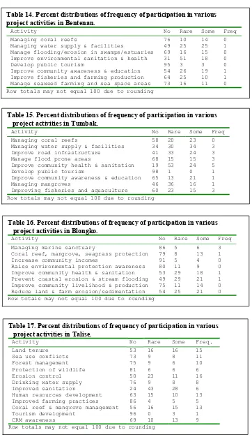
developed in coordination with Tumbak village. The plan addresses eight coastal resources management issues where specific objectives were set to achieve a vision of sustainable community development over a 25-year period. A number of activities are proposed in the plan to address each issue. In addition, the plan calls for the establishment of a management committee to carry out implementation under the supervision of village government.
The major components of the management plan are: 1. Managing coral reefs
2. Managing water supply and facility maintenance 3. Managing flooding/erosion in swamp/estuary 4. Improving environmental sanitation and health 5. Development of public tourism
6. Improving community awareness and education 7. Improving fisheries and farming production 8. Managing seaweed farming and sea space areas
Managing Coral Reefs