_____________________________________________________________________________
Socioeconomic Influences on Coastal Resource
Use in Mahahual, Mexico.
_____________________________________________________________________________ Cinner, J.
2000
Citation:
Kingston, Rhode Island USA: Department of Marine Affairs,University of Rhode Island.
For more information contact: Pamela Rubinoff, Coastal Resources Center, Graduate School of Oceanography, University of Rhode Island. 220 South Ferry Road, Narragansett, RI 02882 Telephone: 401.874.6224 Fax: 401.789.4670 Email: [email protected]
This five year project aims to conserve critical coastal resources in Mexico by building capacity of NGOs, Universities, communities and other key public and private stakeholders to promote an integrated
approach to participatory coastal management and enhanced decision-making. This publication was made possible through support provided by the U.S. Agency for International Development’s Office of
SOCIOECONOMIC INFLUENCES ON COASTAL RESOURCE USE IN MAHAHUAL, MEXICO
BY
JOSHUA CINNER
A THESIS SUBMITTED IN PARTIAL FULFILLMENT OF THE REQUIREMENTS FOR THE DEGREE OF
MASTER OF ARTS IN
MARINE AFFAIRS
ABSTRACT
Coastal resources provide important social, cultural, and economic benefits in many communities throughout the world. However, in many locations resource use practices are degrading the natural resources upon which coastal communities depend. Practices such as intensive and/or destructive fishing can threaten coral reefs and other coastal ecosystems.
Instituting changes in destructive resource use practices is often difficult because such practices may be related to social, economic, and cultural factors. Individuals and communities may participate in or tolerate resource-degrading practices because they may be the only option amidst difficult social and economic conditions.
Initiatives that aim to deter resource abuse should identify and address the underlying factors that lead to such behaviors.
To determine how social and economic factors influence resource use, this thesis will examine relationships between socioeconomic variables (including wealth, education, migration, age, and coastal residency) and the ways in which people use and perceive coastal resources in the fishing village of Mahahual, Quintana Roo, Mexico. There are three main parts to the thesis: First, is a description of the
ecological and social dynamics of the community, including the coastal ecosystems, infrastructure, socioeconomic characteristics, social structures, and resource use practices within and around the community. Second is an analysis of how
socioeconomic variables influence resource use and perception within the community. A sample of local residents provide open-ended comments on a variety of projective stimuli, including photographs of local coastal resources and questions regarding coral reefs, fisheries, tourism, migration, and perceptions regarding the future. The
socioeconomic characteristics of these respondents are examined to see if there are variations in uses and perceptions between socioeconomic groups. Analysis of these data indicates that wealth and education, respectively, are the most important
ACKNOWLEDGEMENTS
I would like to start by thanking the entire community of Mahahual, Quintana Roo, Mexico for welcoming me into their lives. The open arms with which I was received into the community not only provided me with information that is an integral part of this research, but also provided me with friendships that warmed my soul. Special thanks to Don Jesus, Alejandro, Gordo, and Orlando for going above and beyond what I asked of them to ensure that my stay was pleasant and my research was successful. I would also like to thank my research assistant, Humberto Macias Cuellos, whose tireless hours of walking, talking, and translating made the survey aspect of this research possible.
There are many people at the University of Rhode Island and other institutions that contributed significantly to this research. I would like to thank Dr. Christopher Dyer of the University of Rhode Island and Biliana Cicin-Sain of the University of
Delaware for working so hard to find funding from the North American Free Trade Agreement for my research. Thanks to Pam Rubinoff of the Coastal Resources Center, who played an important role in facilitating crucial connections with Amigos de Sian Ka’an and the University of Quintana Roo, and provided technical advise and other resources. The advise, assistance, and resources provided by many members of Amigos de Sian Ka’an was an important component of this research that I greatly appreciate. Thanks to the Secretaria De Medio Ambiente, Recursos Naturales y Pesca for providing me with housing while in Mahahual.
CONTENTS
Chapter Page
1 INTRODUCTION ……….… 1
1.1 Communities Depend on Coastal Resources
1.2 Perceptions About Resources Can Influence the Ways in Which Resources Are Used and Managed
1.3 Social and Economic Factors Affect Resource Use 1.4 Operations to Determine Socioeconomic Influences on Perceptions and Uses of Coastal Resources
2 METHODS……… 14
2.1 Data Collection
2.2 Analysis
PART I. OVERVIEW
3 MAHAHUAL AND SURROUNDING COASTAL ECOSYSTEMS. 20
3.1 Mahahual: A Community at the Cross Roads 3.2 Mangroves
3.3 Seagrass And Coral Reefs 3.4 Inland Environment
4 POPULATION AND SETTLEMENT PATTERNS……… 32
5 INFRASTRUCTURE………... 34
7.1 Social Stratification and Land Tenure 7.2 Formal And Informal Associations 7.3 Sea Tenure
7.4 Enforcement of Environmental Regulations
Chapter Page PART II. ANALYSIS AND DISCUSSION
9 SOCIOECONOMIC INFLUENCES ON RESOURCE USE……….. 71
9.1 Introduction 9.2 Analysis of Socioeconomic Influences on Coastal Resource Use 9.3 Discussion of Socioeconomic Influences on Coastal Resource Use 10 SOCIOECONOMIC INFLUENCES ON PERCEPTIONS OF COASTAL RESOURCES……… 75
10.1 Introduction 10.2 Coral Reefs 10.3 Fisheries 10.4 Tourism 10.5 Thematic Apperception Test 10.6 Migration 10.7 Future Aspirations and Apprehensions 11 DISCUSSION OF SOCIOECONOMIC INFLUENCES ON PERCEPTIONS AND USES OF COASTAL RESOURCES……… 110
PART III. CONCLUSIONS AND RECOMMENDATIONS 12 CONCLUSIONS AND RECOMMENDATIONS………... 120
12.1 Introduction 12.2 Perceived Needs And Key Management Issues 12.3 Suggested Interventions 12.4 Summary APPENDIX I. Survey (Spanish Version)………. 134
English Version………... 139
II. Aquaculture……….. 136
TABLES
Table Page
6.1 Frequency of Productive Activities………... 37
6.2 Distribution of Material Wealth………. 40
6.3 Principal Component Analysis of Material Style of Life ……….. 41
6.4 Correlation Matrix of Socioeconomic Variables……… 44
8.1 Frequency of Fishing Gear Usage……….. 56
8.2 Marine Species Captured in Quintana Roo……… 58
9.1 Socioeconomic Characteristics of Resource Users……… 72
10.1 Relationships Between Socioeconomic Variables and Perceptions about Coral Reefs ……….. 76
10.2 Relationships Between Socioeconomic Variables and Perceptions about Fisheries……… 82 10.3 Relationships Between Socioeconomic Variables and Perceptions about Tourism……… 88 10.4 Responses to Figure 10.1……… 96
10.5 Responses to Figure 10.2……… 97
10.6 Responses to Figure 10.3……… 98
10.7 Responses to Figure 10.4……… 99
10.8 Responses to Figure 10.5……… 100
10.9 Correlation Matrix of Socioeconomic Variables and TAT
Responses………
101
10.10 Relationships Between Socioeconomic Variables and Perceptions about Migration………
105
10.10Relationships Between Socioeconomic Variables and Perceptions about the Future………
108
11.1 Relationships Between Wealth and the Uses and Perceptions of the Environment………...
111
11.2 Relationships Between Education and the Uses and Perceptions of the Environment………...
117
Figure Page
1.1 Quintana Roo and the Yucatan Peninsula………. 3
3.1 Mahahual and the Costa Maya……….. 21
3.2 Main Fishing Beach in Mahahual……….. 21
3.3 Planned Development Along the Costa Maya………... 24
3.4 View of the Reef Along the Coast………. 27
3.5 Reef Profile……… 28
6.1 Educational Attainment in Mahahual……… 37
6.2 Reasons for Migration………... 39
8.1 Man Gathering Almejas………. 53
8.2 Gill Net Usage………... 59
8.3 Fishermen Using a Gill Net………... 61
8.4 Pieces of Coral Caught in a Gill Net………. 61
8.5 A 102 Kg. Jewfish Caught with a Spear……… 62
8.6 Spear Fisherman Standing on Coral……….. 63
8.7 Large Tourism Development in Mahahual ……….. 68
10.1 Beach Scene in Cancun………. 96
10.2 Fisherman……….. 97
10.3 Coral Reef Near Mahahual……… 98
10.4 Coral Reef at Banco Chinchorro………... 99
10.5 Girl Sitting on Bow of Fishing Boat ……… 100
11.1 Relationships Between Wealth and Coastal Resource Uses and Perceptions……….. 101 11.2 Relationships Between Education and Coastal Resource Uses and
CHAPTER 1 INTRODUCTION
This is a study of how social and economic factors influence perceptions and uses of coastal resources in the village of Mahahual, Quintana Roo, Mexico. Understanding relationships between socioeconomic factors and activities that negatively affect the environment is useful in managing natural resources because it can help identify root causes of environmental degradation
,
and allow these factors to be incorporated into an integrated management program. There is considerable literature supporting the theory that social and economic factors influence resource use on community, national, or regional levels (Stonich, 1992; Galvez et al., 1989; White, 1994; Pauly, 1990; McManus et al. 1992). However, the precise nature of these relationships, particularly within Mexico, is not well understood on a household level. Much of the socioeconomic data in Mexico are compiled by independent researchers and Non-Governmental Organizations (NGOs), and have yet to be applied to resource management (personal communication. Dr. C. Dyer, 3/00).The supposition of this research is that the various ways in which people perceive and use coastal resources are dependent upon socioeconomic variables (including wealth, education, migration, age, and coastal residency). To determine which socioeconomic variables are most influential, this study examines relationships between household socioeconomic characteristics and the ways in which people perceive and use coastal resources. This information is then incorporated into a resource management context by recommending interventions that address the underlying factors behind resource degradation.
1.1 Communities Depend Upon Coastal Resources
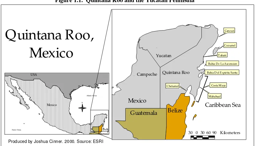
The coastal environment of the Mexican State of Quintana Roo (figure 1.1) supports considerable tourism and fishery industries, upon which many residents depend for income and/or subsistence. Quintana Roo’s diverse coastal environment is characterized by world famous tourist beaches such as Cancun and Cozumel, prolific mangroves in the Esprito Santo and Ascencion Bays, and part of the second largest coral reef system in the world, the Meso-American Barrier Reef. Though all of Quintana Roo’s coastal ecosystems are of great economic and social importance, coral reefs, in particular, are crucial because they protect the coastline against hurricane damage and beach erosion, sustain subsistence and commercial fisheries, provide sand for beaches, and create recreational opportunities such as scuba diving. The social and economic base of many communities within Quintana Roo has evolved to depend, at least in part, upon the beauty and bounty of coral reef systems.
reefs and other coastal resources is often difficult because the various ways in which people utilize their natural resources is invariably related to a multitude of social, cultural, and economic factors (Nazarea et al., 1998; Stonich, 1992; Galvez et al., 1989; White, 1994; Pauly, 1990).
Figure 1.1. Quintana Roo and the Yucatan Peninsula
USA
Bahia D el E spiritu Santu
Costa M aya
Mahahual Chetumal
30 0 30 60 90 Kilometers
N
Quintana Roo,
Mexico
Produced by Joshua Cinner. 2000. Source: ESRI
1.2 Perceptions About Resources Can Influence the Ways in Which Resources Are Used and Managed
Recent literature about natural resource management (Pollnac et al., 1997; Pollnac, 2000; Nazarea et al., 1998) highlights the importance of understanding and incorporating local perceptions into resource management initiatives. In their study of perceptions about local resources in the Philippines, Nazarea et al.(1998) noted that individuals and communities utilize their surrounding resources based on a variety of social and cultural factors that shape their perceptions of the resource. Nazarea et al. (1998) claim “such factors can determine whether something is perceived as a resource and put to extractive or sustainable use or, alternatively, dismissed and neglected-or actively exterminated- as a non-resource.”
an understanding of local populations’ own internally defined standards, many of which are qualitative, non-monetary, non-material, and long-term and which often define what makes life, society, and the environment worthwhile. These culturally defined standards may include aesthetic, emotional, moral, religious, cosmological, and even inter-generational or “bequeath” considerations having a direct bearing on resource management.
For projects that aim to promote sustainable uses of coastal resources, it is important to understand which resources a community places values on and which they do not. In a baseline assessment of two coastal communities, Pollnac (1997) states “It is essential to understand individual perceptions of factors influencing the status of coastal resources prior to attempts to involve people in community-based management efforts.” According to Pollnac (2000; p.1), resource management projects may need to “either direct outcomes at local values or somehow change these values.” Gaining an understanding of how local communities perceive natural resources can allow developers of Integrated Coastal Management (ICM)1 initiatives to adapt and refine management strategies to reflect the needs and desires of the stakeholders.
1.3 Social and Economic Factors Influence Coastal Resource Use
It is important to recognize that communities do not necessarily have a single perception regarding their natural environment. Social and economic factors can influence how people perceive their resources. Nazarea et al. (1998) state:
Different groups within local populations (e.g. rich versus poor, landed versus tenants, . . . old versus young) may have different perspectives and priorities in appraising their quality of life or their environment. In short, different categories of people view “reality” with different lenses based on their positions in the internal socioeconomic hierarchy. These different vantage points can help account for how each group or category of individuals manages the resources at its disposal to attain goals it considers important, as opposed to pursuing the goals of scientists or planners. Understanding these variations both within groups and among outsiders, can help facilitate the search for a common ground in the pursuit of broader goals such as environmental management…
Even when individuals or communities are interested in pursuing goals such as environmental management, social and economic cycles may influence their resource management decisions. In a study on how poverty can influence resource use in rural Honduras, Stonich (1992) claims that poverty often exacerbates resource abuse.
1
Stonich (1992, p. 386) states “because of economic and population pressures, governments and individuals are overexploiting the natural resources they control in order to generate income to satisfy immediate needs – whether those requirements are to generate foreign exchange at the national level or to increase current income at the level of the household.” For example, economic pressures may force poorer farmers to utilize land more intensively by cultivating higher proportions of their land and shortening fallow periods (Stonich 1992, p. 291).
As economic, social, and population pressures increase, resources may become over-utilized, stressed and less productive, which in turn forces people to further exploit their resources, creating a feedback cycle. Extreme resource degradation can disrupt local communities (White et al. 1994) and force people to migrate in search of better resources (Ruitenbeek, 1996). White (1994, p. 2) claims that as a result of coral reef degradation:
fishery catches decline, tourism suffers, coastal erosion becomes more severe, and local economies loose their resource base. Deterioration of customary resource use and tenure systems result from coral reef destruction and contributes to it. Social problems in coastal communities are made worse as people’s traditional modes of livelihood decline.
This cycle is further exacerbated by what Pauly (1990) claims is a traditional perception of the fishery being a “dump” for excess labor. Where economic opportunities are lacking, subsistence and commercial fishing can become saturated leading to over-fishing and resource degradation (Pauly, 1990; Laroche and Ramananarivo, 1995). Where unemployment prevails, it is likely that the sectors of the fishing industry that will become most exploited are those that are least capital intensive. McManus et al. (1992, p. 3) claim, “in the Caribbean, spear fishing is becoming an increasingly important economic activity as a result of socioeconomic factors related to underemployment and to the low outlay of capital equipment.” Unfortunately, spear fishing and other practices that require relatively small capital investments are often quite destructive to coral reefs (see section 7.5).
Though resource abuse can damage a community’s means of livelihood, tolerance of resource-degrading practices can be explained, in part, by Maslow’s theory of a hierarchy of needs (Maslow 1970). According to Maslow (1970), inability to meet basic needs such as food, shelter, and security can prevent people from pursuing loftier ambitions. For individuals or communities that are continually struggling to meet basic needs, many of the motives behind resource conservation (i.e. that there is an intrinsic value in nature) can seem too lofty to prioritize over their basic requirements; particularly when they require sacrifices. Despite legal sanctions, potential health threats, and the damage inflicted on coastal resources, communities may tolerate resource-degrading practices because they may be the only available livelihood option amidst chronic poverty (Galvez et al., 1989).
in which people in the community perceive and use their coastal environment. However, choosing appropriate indicators to measure socioeconomic variables, particularly wealth, can be difficult.
1.4 Measuring Wealth
Cowell (1977) defines wealth as the sum of ones assets at a particular point in time. Wealth can include land ownings, possessions (household and work related-fishing/farming gear), vehicles (boats, cars), money in the bank, the value of stocks and bonds, etc. According to Cowell (1977), wealth is an important and accurate indicator of economic and social well being because it “represents a person’s total and immediate command over resources.” Wealth can be measured on individual/household, community, national, and regional levels using a variety of indicators. However, concepts of wealth can vary considerably between cultures and communities.
Despite its cultural variations, wealth is used as an indicator of economic and social well being in a wide array of applied anthropology and development work (Kjell, 1997; Pollnac et al., 1997; Jones, 1996; Adams et al., 1997; Scoones, 1995). Examining wealth as an indicator of an individual, household, or community’s well being has been an integral participatory research technique employed by many researchers involved in rural development (Pollnac, 1989; Jones, 1996; Adams et al., 1997; Scoones, 1995; Kjell, 1997). Adams et al. (1997), citing Chambers, 1994, claims “wealth ranking has become an increasingly accepted means of assessing relative socioeconomic status in the context of applied research projects and development programs.” Measuring wealth is developing into a standard practice in rapid assessments of communities [often called Rapid Rural Assessments (RRAs) or Participatory Rural Assessments (PRAs)] which are useful because data can then be compared between communities and cultures (Adams et al. 1995; Pollnac, 1998; Jones, 1996). However, both Pollnac and Jones emphasize the importance of not transforming wealth ranking into a checklist type research that excludes local perceptions of wealth. Wealth ranking has become a popular component of community assessments because it can allow for a high degree of cultural flexibility.
Using wealth as an indicator of economic well being is an especially pertinent technique in the context of developing nations. According to Townsend (1970), in the cash economy context of many developed countries, measures such as income are relatively accurate measures of well being. Townsend claims that developed societies exhibit high monetary incomes, but low in kind incomes. In this situation, income may be an effective measure of well being as income information may be widely available and easily interpreted (Cowell, 1977). Cowell (1977) defines income as a change in a person’s command over resources over a given time period. Because income reflects only the change occurring during the arbitrary time period (day, month, year) it has the disadvantage of excluding past accumulations of wealth, except when they are income-yielding investments (such as stocks and bonds). Cash income also excludes in kind income, which may be difficult to place a dollar value on.
Townsend (1970), rural societies tend to exhibit low monetary incomes, but high in-kind incomes. For example, a household which practices farming as its main productive activity may raise and eat goats, chickens, pig, cows, and a variety of vegetables, but not have a cash income representative of the quality of their diet. Thus, while examining well being in developing nations, income is simply not an accurate measure of social status, and a more broad-based, culturally appropriate definition of wealth must be developed.
Indicators of wealth can include concepts such as material style of life (MSL) and income, which are easier to examine on a smaller scale. MSL analyzes the household possessions within a survey population and constructs a scale based on the interrelationship between these items (Pollnac et al., 1997). Households are scaled based on the presence or absence of these possessions. MSL is easily examined on an individual/household level and does not require as large a sample size as indicators such as child mortality require for accuracy. This study utilizes MSL as a wealth indicator.
Some wealth indicators such as MSL can present problems if it is necessary to convert the wealth into money terms, as market prices may not reflect the relative utility that the items offer (Cowell, 1977). However, this study does not attempt to covert MSL into money. Cowell, 1977 also claims that wealth can present problems by not accounting for non-tangible investments such as education. While some researchers (Scoones, 1995; Adams, et al., 1997) have incorporated formal education into their wealth ranking, this study will explore education as an independent indicator of well being.
Development agencies such as the UN may incorporate health, presence or absence of resources (resources can include cash, capital assets, value of employee benefits, value of public services, and in-kind income), dietary information (caloric intake and nutrients), child mortality, educational attainment, and literacy in their measures of wealth (Townsend, 1970; Adams et al. 1997). However, the accuracy of many of these figures is dependent upon a relatively large sample size. For example, in the use of child mortality as an indicator, the death of one baby can give a household a 100% child mortality rate, which may not be representative of the social conditions the family lives in. Large sample sizes could present problems for one researcher with limited resources. Some of these indicators, such as dietary information may also vary dramatically with the season (Chambers, 1983). Wet/dry seasonal variation in food production and consumption may leave a researcher conducting a rapid assessment with very skewed data (i.e. people could either be very hungry or have an abundance of food, neither of which would necessarily be representative of yearlong average conditions).
might lead to misleading interpretations.” Thus, it is critical that emic (community specific) measures of well-being are based on criteria offered by local people incorporating views and perceptions of their environment (Scoones, 1995; Nazarea et al., 1998; Adams, 1997; Jones, 1996).
Individual or household wealth can be influenced by many factors including income, education, occupation, tradition, political/social connections, ethnicity/race, remittance from abroad, and others (Townsend, 1970; Scoones, 1995; Adams et al., 1997). Adams et al. (1997) claim that in general, wealthier households demonstrate statistically significant better health, larger physical space, land ownership, have higher proportions of educational attainment, fewer dependents, among other expected findings related to wealth than poorer households. Due to the complex nature of social, cultural and economic factors that influence social stratification, there is not one effective measure of well being. Material style of life was chosen for this research because can be an emically-derived indicator of well-being that is easily measured and accurate for relatively small sample sizes and it does not exhibit proportionally large seasonal fluctuations.
1.5 Operations to Determine Socioeconomic Influences on Perceptions and Uses of Coastal Resource Uses
To find out how socioeconomic factors influence perceptions and uses of coastal resources, this thesis explores whether relationships exist between household socioeconomic variables (including education, age, migration, wealth, and coastal residency) and various perceptions and uses of coastal resources. A formal survey was used to elicit data about resource use, perceptions about resources, and household socioeconomic characteristics from the heads of households in the village of Mahahual, Quintana Roo, Mexico.
CHAPTER 2 METHODS
2.1 Data Collection
Research for this thesis was conducted in Mahahual, Quintana Roo, Mexico from May to July, 1999. The boundaries in this study range approximately 12 kilometers north and 11 kilometers south of the village. The Northern boundary of the study was Rio Indio, a small community of several houses, a couple of bungalows, and a tiny store on the side of a house (figure 3.1.1). The southern boundary of the study was the hotel El Castillo.
Methods used to collect the data for this thesis included participant observation, key informant interviews (such as governmental officials, participants in various coastal activities, and village officials), 37 surveys of the heads of households (see appendix I for the survey instrument), and collection of secondary data (such as village statistics). Before the survey instrument was developed, one month was spent in the community observing, listening, asking questions, and engaging in a variety of coastal activities (commonly called participant observation). Throughout the research, 18 days were spent at sea with local fishermen partaking in a variety of fishing and tourism practices.
Thirty-seven of sixty-five households in the community were surveyed to elicit information on socioeconomic well-being, use of coastal resources, and perceptions of coastal resources (fisheries, coral reefs, forests, tourism) and other issues relating to coastal management (migration and hopes/worries about the future). Wherever possible, survey responses were confirmed by observations. For example, several people claimed that mangroves were not utilized in the area. However, observations indicated that mangroves were in fact used for construction and other purposes.
The survey examined socioeconomic information such as the age, years of formal education, length of time in Mahahual (referred to as “migration”), amount of time per month (referred to as “residency”), and wealth of respondents. Wealth was measured using a Material Style of Life (MSL) scale. From the survey information, each household has an individual value for each socioeconomic variable. These data are the basis for the overall analysis.
resources, similar to the Thematic Apperception Tests (TATs)2 employed by Nazarea et. al (1998) and Pollnac (2000).
A local resident who spoke proficient English was hired to assist in transcribing and translating the surveys, which were conducted in Spanish. Surveys were reviewed and translated within 24 hours, so that details could be added which may not have been initially recorded. Tape recorders were not used because residents of Mahahual generally view them as intrusive.
While a random survey method was initially attempted, an opportunistic survey method was eventually adopted. Opportunistic samples can be bias. An opportunistic method was adopted because heads of households were commonly gone (fishing, farming, or at their other home) for unpredictable and often long periods of time. In the context of household survey methodology, households are typically selected at random; however, if one or more is not willing or able to participate, a default location can be selected. Given the small size of the community, the opportunistic survey method used by this research should not introduce a great deal of bias because every household was initially a primary or default survey option. In order to complete a sufficient number of surveys given the time constraints of this project, I had to survey
every household that was available and willing to participate. Every household in Mahahual was contacted and every household in the community that was willing or able to participate in the survey did.
Interviewing the heads of households is potentially gender-biased, because in this culture males are typically viewed as the heads of household. Thus, few females were interviewed. This may introduce bias in the descriptive statistics of the community (i.e. formal educational attainment may be different for males and females) and in areas of the research where males and females perceive things differently. In their Thematic Apperception Test, Nazarea et al. (1998) found several differences in the ways males versus females perceive the natural environment. Despite its gender-biased shortcomings, this methodology was adopted because it is culturally inappropriate in that region for two males (the research assistant and myself) to interview someone’s wife in private. Female focus groups would have also been inappropriate and were, thus, not adopted. For the purposes of this thesis, persons that participated in the surveys are referred to as “respondents.” Persons that participated in formal interviews (i.e. set meetings with government, university, or agency officials) or informal interviews (i.e. talks to fishermen on the beach) but may not have partaken in the survey are referred to as “key informants”.
2.2 Analysis
Because data about coastal resources were gathered by two different methods (direct questions and TAT), two types of analyses were required to determine whether significant relationships exist between the independent and dependent variables. For analysis of the direct questions, households that have similar responses to questions regarding resource use3 or perceptions were grouped together. Mean values of socioeconomic variables were then obtained for the group. The t-test was used to test statistical significance of observed differences between mean socioeconomic characteristics across groupings formed by response categories.
Responses to the five photographic stimuli (TAT) were also grouped based on their content. Respondents were given a point for each category included in their response. Only reoccurring response categories were included in the final analysis. Respondents’ socioeconomic variables were then correlated to their respective response category points using the pairwise Pearson’s correlation model. Statistically significant relationships between socioeconomic variables and the uses and perceptions of coastal resources (both open-ended and TAT responses) were then examined to determine whether general trends exist between socioeconomic characteristics and the various ways that people use and perceive coastal resources.
CHAPTER 3
MAHAHUAL AND SURROUNDING COASTAL ECOSYSTEMS
3.1 Mahahual: A Community at the Cross Roads
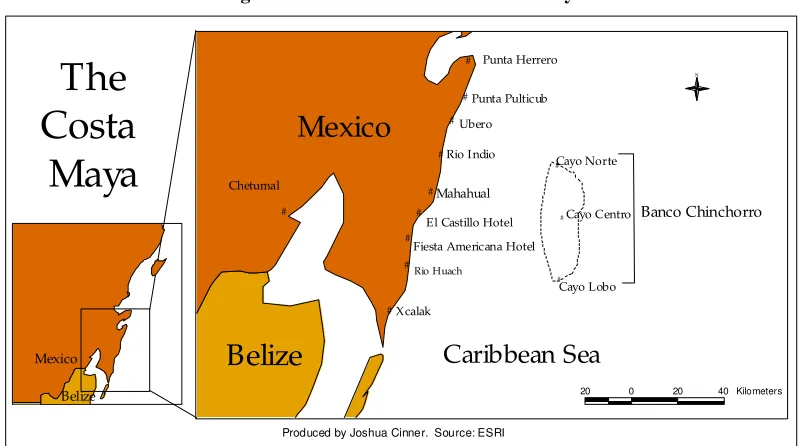
Several hours by car south of the hustle and bustle of famous Mexican tourism destinations such as Cancun, Cozumel, and Tulum, lies a vast, yet virtually untouched stretch of coastline referred to as the Costa Maya (figure 3.1). Characterized by prolific coral reefs, long beaches, and a practically impenetrable semi-arid lowland forest, local residents consider the Costa Mayaone of Mexico’s last frontiers. Along the coast, palm trees tower over beaches that are littered with seagrass, soda bottles and other plastic waste. Occasionally, a group of several parked fishing boats will indicate that a particular section of beach is used for fishing activities. About half way down the Costa Maya, the seemingly endless forest, palm trees, and mangroves that line the coast is briefly interrupted by a sleepy little fishing town called Mahahual.
Mahahual is a small Caribbean coastal community of about 300 people located 56 km to the north of Xcalak and 140 km from the city of Chetumal, in southern Quintana Roo, Mexico. Surrounded by the crystal-clear Caribbean Sea on one side and mangroves beginning no farther than 250 meters inland on the other, Mahahual seems hardly more than a strip of sand. The community is located just inland of the main fishing beach that is the social, political, and economic center of the town (figure 3.2). Almost all of the community’s social activities, including sports tournaments, evening volleyball games, boat and equipment repair, festivals, town meetings, and even political elections are conducted at the main beach. The beach is broken up by several privately owned and fenced off parcels of beach-front property.
Figure 3.1 Mahahual and the Costa Maya.
Mahahual
Produced by Joshua Cinner. Source: ESRI
Mexico
Belize
The multiple colors of the water on a calm day reflect the diversity of marine ecosystems, including seagrass beds, coral reefs, and pelagic waters. The bountiful fishery resources within these ecosystems attracted the most recent group of settlers to the coast. The majority of residents live behind a hotel, store, and three restaurants that lie across the street from the beach. The poorer households in the community have walls of vertical wooden posts (cedro, caoboa, jabin, zapote, chitramon, tzalam, and mangrove) and are roofed with a tarpaper-like substance referred to as lamina de carton. In stark contrast to these shanties, some of the wealthier residents live in two-story concrete houses. In the main area of town, the majority of buildings are on the inland side of the road. A dilapidated house on the seaward side of the road was damaged by Hurricane Mitch and attests to the necessity of building away from sea in this low-lying area.
Most residents in Mahahual make their living from the coastal environment, which provides them with a social, economic, and often spiritual connection with the coast. Productive activities include fishing, farming, hunting, black coral collection, tourism development, residential construction, wood collection, and a dive tourism industry. Some resource-use practices, particularly net and spear fishing, can cause considerable damage to coastal resources.
Fishing has long been the economic backbone of Mahahual. Currently, 65% of the 65 households in Mahahual engage in some sort of fishing activity. Fishing practices around Mahahual include gill and cast netting, spear fishing, hand and long line fishing, gleaning, and sport fishing. Fortunately, there are few reports of extremely destructive fishing techniques such as blast fishing or cyanide fishing which can devastate coral reef systems.
transportation is poor, resulting in spoilage of products and other difficulties. Recently, limited tourism has begun to provide some residents with an alternative income source.
Residents of Mahahual are caught at the crossroads of wanting to improve economic conditions by promoting tourism development, and wanting to preserve the rustic lifestyle, tranquillity, and natural beauty that the community now offers. The government and local residents are considering a fundamental shift to a tourism-based economy. Fide Caribe, a branch of government responsible for tourism development, has plans to develop the Costa Maya from Xcalak to Punta Herrero (figure 3.3). Mahahual is targeted to be the epicenter of this massive development project. Fide Caribe aims to build a cruise ship pier, airport, hotels, and increase Mahahual’s population from under 300 to over 100,000 in the next 15 to 20 years (Personal communication, Dr. F. May). New roads, a cruise ship terminal, and an airport have already been constructed. Kottak (1999) presents an in-depth and long-term (almost 40 years) ethnographic study of the socioeconomic impacts of tourism and economic development on a small coastal community in Brazil.
Though residents are interested in the opportunity for tourism-based improvements in infrastructure and material wealth, some residents are apprehensive about the environmental and social changes associated with such large-scale development. A shift to a tourism-based economy may be detrimental to members of the community who are unprepared or unwilling to accept employment in the tourism sector because traditional productive activities such as fishing will be displaced. Residents claim that tourism developments in the north such as Tulum have left a legacy of geographic relocation, economic isolation, and the privatization of once public beaches.
Punta Herrero:
10 0 10 20 30 40 Kilometers
3.2 Mangroves
Mangroves can be seen as far back as 20 km inland, though the majority of mangroves begin 50 m inland and range back approximately several hundred meters. There are four distinct species of mangroves: rojo/red (Rhizophora mangle), blanco/white (Laguncularia racemosa), botoncillo/little button (Conocarpus erectus), and negro/black (Avicennia germinans). An interesting observation was that the mangroves rarely extend to the waterline. When questioned about this, several key informants that have been there for up to 25 years mentioned that there have never been mangroves that extend to the waterline. Informants suggested that mangroves were cleared for the coconut plantations that dominated the coast before Hurricane Janet damaged the coconut industry in 1955.
Currently, local residents use mangrove wood for firewood, dye, construction of houses (roofs, posts, and walls), construction of fences, and mangrove swamps for land reclamation, sewage disposal, and as a dumping ground for garbage. The wood from mangroves is considered soft and many residents do not like to use it for construction. Activities that affect the mangroves include; dumping of trash, burning (typically for agriculture or development), development (including residential, tourism, and road construction), utilization for wood, disposal of sewage, and hurricanes.
understanding among community members that mangroves are legally protected, though observation and confirmation by several respondents indicate that harvesting, though minimal, continues despite legal protection. The only historical use of the mangroves that is not currently being practiced is hunting, the reasons for which will be discussed in section 3.4. Respondents claim that barriers to utilization of the mangrove resources stem mainly from their protected status, and the potential expense of violation. However, residents do not perceive access restrictions to the resource as a pressing issue because the use of mangroves is minimal and enforcement of environmental regulations is poor.
Perceptions about the mangroves are such that some residents do not believe there have been, will, or even can be profound changes in the mangroves. These beliefs will be important if trying to implement a more comprehensive protection strategy, because they indicate that some residents may not see the need or importance of protecting the mangroves, and sensitization about the importance of mangrove ecosystems may be a necessary step during implementation of an ICM program.
3.3 Seagrass and Coral Reefs
Seagrass beds are prolific in the coastal lagoons. Except in the few locations where there are breaks in the reef, seagrass is often too abundant to allow for swimming. Thick piles of seagrass frequently wash up on beaches. Activities occurring in the seagrass ecosystem include gleaning (mainly for conch and a small clam called “almeja”), and digging channels (sometimes with a pickax) for boats to exit the reef lagoon during high tide.
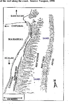
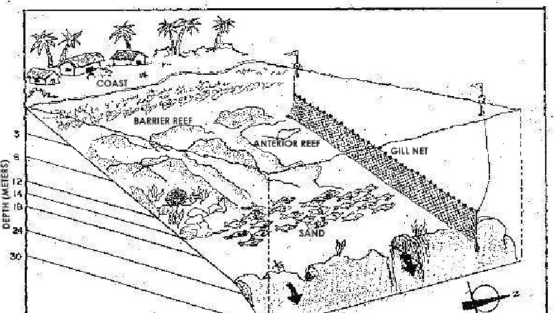
Figure 3.4. View of the reef along the coast. Source: Vasquez, 1998
Figure 3.5. Reef Profile
a) Reef profile in front of Mahahual. b) Reef profile two km south of Mahahual. Source: Perera et. al, 1994
Approximately two kilometers north of Mahahual, at a planned site for a cruise ship pier, reef formations change dramatically. The fringing reef of the south gives way to a zone where the reef and land coincide to form cliffs. This formation results in higher wave action, deeper water, and fewer corals. The direct deep-water access may be responsible for the selection of this particular location as a cruise ship terminal.
Further north around Rio Indio, the benthic topography flattens out and currents seem considerably stronger. There are coral formations on the bottom, but they are few and far between, usually appearing as a single head of lettuce or brain coral. Rio Indio is a favored site among fishermen, who claim that it is less fished and there are more desirable fish there than around Mahahual. Rio Indio may also be favored because the nets often used in fishing there may sustain less damage in this area from the lack of reef, thus cutting down repair costs and time.
lies some 45 kilometers off the coast of Mahahual. In a government effort to promote the sustainable use of the islands, Banco Chinchorro received protected area status in 1998. However, the enforcement of protected area status is negligible.. In the local fishing boats, the ride is 2-2 ½ hours and is extremely rough, even on a seemingly calm day. Based on observations and the reports of key informants, the reefs and fish populations around Chinchorro are in much better condition than nearer the mainland. The seaward sides of the atolls have a connected fringing reef that spans the entire length north to south. There are numerous shipwrecks around the atolls, which have immense tourism/diving potential, but if practices such as pillaging the wrecks for pottery and other material continue the potential will quickly diminish.
3.4 Inland Environment
The inland environment is also an important source of resources for the community of Mahahual. Informants identified a variety of resource uses in the forest, including: timber collection (caoba, cedro, geanadillo, zapote, chacte viga, and other hardwoods), guano collection (material used to make thatched roof constructions called palapas), hunting animals (wild turkey, peccary, white tailed deer, peacock, jaguar, ocelot, crocodiles, turtles), cattle ranching, agriculture (maize, cucumber, bananas, watermelon, and other fruit), collection of construction materials (residential and tourist), collection of vines for art and palapa construction, clearing for residential expansion, and creation of fire lines to prevent and control wildfires. Resources from the inland environment have traditionally been the basis of productive activities for many of the residents that live inland.4
While no permits are required for subsistence hunting (personal communication, Head Biologist, Uyumil Ceh Biological Reserve), permits are required to carry guns. Hunting is somewhat limited by the presence of soldiers and marines in the area that routinely patrol for drug trafficking and guns. It was mentioned that since many residents do not have official permits for their arms, they were less likely to go hunting because the soldiers and marines would confiscate their arms and fine them for lacking gun permits.
According to respondents, there are a number of issues that affect their ability to utilize inland resources. Problems include: resource degradation, restrictions on logging and burning, permit requirements, land ownership/tenure, lack of organizations and institutional support, and outdated laws that are not considered locally applicable. However, it was also mentioned that there are typically no problems accessing forest resources for subsistence uses.
4
According to key informants and respondents,coconut farms called “copra,” exploitation of chicle
CHAPTER 4
POPULATION AND SETTLEMENT PATTERNS
The local health clinic reported a full-time population of 261, consisting of 121 females and 140 males living in 33 households. The local (now former) Delagado (the locally elected municipal representative), reported a population of roughly 200 within the town, and 347 including K55 (see below for description of K55) and extending south a couple of kilometers. Observations indicate that there are 50 houses that are occupied by full-time residents. Contradictions in these numbers are due to a number of causes, including poorly defined geographical boundaries and a highly transient population. The average number of occupants per household can range from four to eight, depending on which population and household estimates are used. Household occupancy is highly varied because some households are occupied full-time by families and other are occupied by fishermen whose family lives somewhere else.
The central community itself is rather small, stretching back from the beach only 7 houses at its widest point. The majority of housing is clustered around the central area of Mahahual, but households are dispersed along the southern coast for 15-20 km. There are less than 80 houses within a 2-km stretch south of the central community, of which approximately 50 are occupied full-time. There is also a dispersed settlement several kilometer inland from the main village, referred to as K55 because this marks the 55th kilometer of road from the main highway (indicated by a highway marker). There are 13 additional houses with full time residents in K55, and three or four more that may be occupied part time or under construction.
CHAPTER 5 INFRASTRUCTURE
Mahahual lacks municipal services such as electricity and water. There are three stores and five restaurants, though only three of the restaurants serve food regularly. There is a three floor concrete hotel, Hotel Mahahual in the center of town, and several bungalows that tourists can rent to the south of town. Hotel Mahahual supplies generator and solar produced electricity and pumped water to several community residents, who have connections to the hotel (through employment, family, etc.). A sandy road passes along the shore through the front of the town, which was the main road to Xcalak before a newer road was completed several kilometers inland in 1998.
Since there are no rivers or streams, fresh water for bathing and household use is obtained by numerous wells that are about 6 feet deep. However, 70% of households surveyed in the community drink bottled water. The only people that reported drinking water directly from their wells were several of the farmers that live inland at K55. Some 34% of surveyed households have a pit latrine and 49% have a concrete-lined septic tank. Twelve percent of the households reported neither and claimed to use the bushes and mangroves for toilets. In all cases, sewage is not properly treated for nutrients and the system may not even remove pathogens, which could leave the high water table especially susceptible to groundwater contamination.
Mahahual has a municipal dump; however, it is about eight kilometers, away and local residents without personal transportation have no means to bring their refuse to the dump. The dump was mentioned as a solid waste disposal method in 32% of the households surveyed. Some 51% of the households burned at least a portion of their solid waste, and 24% either buried their waste or illegally dumped it in the mangroves or bushes. A further 10% composted at least a portion of their waste. Shifts in the packaging of certain products have also led to increased volumes of solid waste. For example, disposable glass soda bottles have replaced most of the traditional returnable glass soda bottles, so the community has the burden of disposing of bottles that were formerly returned.
CHAPTER 6
SOCIOECONOMIC CHARACTERISTICS 6.1 Occupations
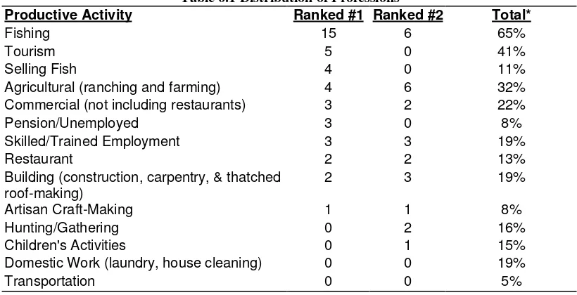
Households in Mahahual display occupational multiplicity. The sample of 37 households reported 40 distinct productive activities. Fishing is a productive activity in 65% of the households5, making fishing is the most popular activity in Mahahual (table 6.1). Other popular activities include farming and operating boat tours along the coast or to Banco Chinchorro. Diversification of productive activities allows residents to receive income when fluctuations such as seasonal variations and weather-related phenomena affect their primary productive activities. The proposed shift to a tourism economy will displace many currently practiced productive activities such as fishing and could be difficult for residents during the tourist off-season times or if tourism does not meet expected levels.
Table 6.1 Distribution of Professions
Productive Activity Ranked #1 Ranked #2 Total*
Fishing 15 6 65%
Tourism 5 0 41%
Selling Fish 4 0 11%
Agricultural (ranching and farming) 4 6 32%
Commercial (not including restaurants) 3 2 22%
Pension/Unemployed 3 0 8%
Domestic Work (laundry, house cleaning) 0 0 19%
Transportation 0 0 5%
* See footnote 5 6.2 Education
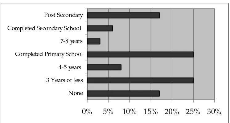
Education is widely used as an indicator of wealth and social status (Pollnac et al., 1997). Respondents were questioned about their years of formal education (figure 6.2). Respondents have an average of six years of formal education. However, it should be noted that only the heads of households are interviewed, thus this average may not be representative of the educational attainment of the entire population.
Mahahual has a primary school and a very recent (August of 1999) secondary school. In the primary school there are 40 students; seven students in first year, seven in second year, five in third year, nine in fourth year, five in fifth year, seven in sixth year. There are only two children of primary school age that do not attend. At the time of the research, the secondary school was not yet open hence there is no data for student attendance at that school.
5
Figure 6.1. Educational Attainment in Mahahual
0% 5% 10% 15% 20% 25% 30%
6.3 Migration
Of the 37 household heads interviewed, only one was born in the Mahahual area (Rio Indio). Due to the relative homogeneous migration status of respondents, analyses in chapters nine and ten regarding migration will be based on how long residents have been living in Mahahual rather than if they have migrated. The length of residency variable (referred to as simply “migration” in the analysis) is included primarily to discern whether long time residents have special concerns that could be addressed by an ICM program.
The median time that the respondents have lived in Mahahual is eight years (the mean time in Mahahual is 10 years, but this figure may be less representative than the median because it is distorted by extremes such as residents that have been there for 70 years). Many respondents also mentioned that they had only lived in Mahahual for a few years but had been coming to the area (typically for fishing) for a number of years. Many residents are originally from the State of Quintana Roo. Other common origins include the states of Vera Cruz and Yucatan.
Figure 6.2 illustrates the frequency of reasons that people moved to Mahahual. The primary reason for migration is employment opportunities in the fishery and other fields. This indicates that people moved to Mahahual primarily because of economic need, but also means that they had confidence in the natural resources of the area. Ruitenbeek (1996) states “population movement can be a useful indicator of environmental security.” Perceptions regarding the state of coastal resources will be discussed further in chapter ten. Other reasons include: quality of life, presence of family and friends, health concerns, and being displaced from fishing by the Sian Ka’an reserve to the north.
Figure 6.2. Reasons for migration to Mahahual
Mahahual is somewhat transient. Some people come to fish for a week or a weekend a month, others move to Mahahual for the lobster and conch seasons. The amount of time per month that respondents spend in Mahahual (referred to as residency in the analysis) is included to determine whether there are variations in the
0% 10% 20% 30% 40%
perceptions of full-time versus part-time residents. Information was gathered regarding the number of days per month that respondents reside in Mahahual. The average number of days per month that respondents live in Mahahual is 27. However, this average is high because many cooperative members (typically part-time residents) were either not present or busy with preparations and unavailable to interview.
6.4 Material Style of Life
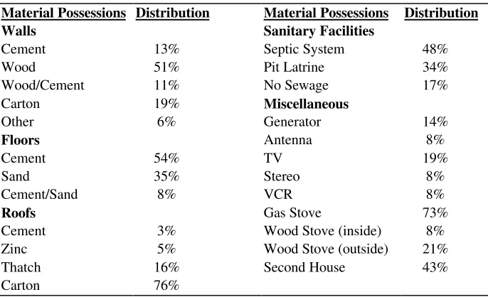
According to Pollnac et al. (1997), Material Style of Life (MSL) can be an indicator of relative wealth or social status in a community. MSL is a method of measuring wealth based on the presence or absence of household possessions. To determine culturally appropriate indicators of wealth, key informants were asked to describe the house of a rich person and the house of a poor person. A list of 24 items was developed including items such as a television, VCR, satellite antenna, gas stove, wood stove, electrical generator, vehicle, type of bathroom (septic system or pit latrine) and the type of walls, roof, and floor. Table 6.2 shows a distribution of these items within the community.
Table 6.2. Distribution of Material Wealth
Material Possessions Distribution Material Possessions Distribution
Walls Sanitary Facilities
To provide a clear picture of the distribution of material wealth within the community, a scale can be constructed based on the interrelationship between these items (Pollnac et al., 1997). These items were factor analyzed using the principal component method and varimax rotation, resulting in two material style of wealth factors that explained 45% of the variance (table 6.3). Factor 1 explained 24% of the variance and factor 2 explained 21%. Nine items did not have significant loading on either factor and were discarded from the analysis.
Table 6.3.Principal component analysis of material style of life
Item Factor 1 Factor 2 Item Factor 1 Factor 2
VCR .764 .215 Gas Stove .223 .688
Antenna .743 -.023 Second House .188 .639
Cement Floor .677 .411 Latrine -.079 -.611
Sand Floor -.617 -.225 Wood Stove -.102 -.572
Generator .521 .395 Vehicle -.202 .494
Cement Walls .467 .350 Carton Walls -.328 -.442
No Sewage -.371 -.162
bold denotes high factor loading
As indicated by table 6.3, the items that have the highest positive loading on the first component are TVs, VCRs, satellite antennas, cement floors, generators, and cement walls. Items with high negative loading on the first factor include sand floors, and the lack of sewage facilities. Thus, factor one (subsequently called “wealth factor one”) is comprised of accessories and floor structure.
Items with high positive loading on the second factor include septic systems, gas stoves, possession of a second house, and a vehicle. Items with high negative loading on the second factor include latrines, wood stoves, and carton walls. The second factor (subsequently called “wealth factor two”) is comprised of household structure, amenities, and luxury items.
The items on wealth factor one suggests that households with high loading on this factor are more settled in Mahahual. Items such as TVs, generators, VCRs, and satellite antennas could be stolen if a watchful eye were not kept on the items. Wealth factor two indicates a different type of wealth than wealth factor one. Due to the high positive loading of both a second house and vehicle, the second wealth factor represents a high degree of mobility. One would expect that a members of households with a high wealth factor two loading come to the coast to engage in productive activities and have families in another location. However, since structural and accessory items are present on both factors, distinctions between these two items are not clear cut. Thus, these wealth factors should be viewed in tandem rather than as independent wealth indicators.
A score on the component scale is calculated for each household based on the
presence or absence of items in their household. Pollnac (1997) states “the factor (or component) scores are the sum of the component coefficient times the sample
standardized value.” Thus, each item has a contribution to the factor score based on its loading in table 6.3. Items with high positive loading have a stronger contribution than those with low or negative values. Factor one scores in the community range from –1.049 to 3.053. Factor two scores range from -1.848 to 1.638. Scores are standardized, and have a mean of zero and a standard deviation of one.
6.5 Ethnicity and Religion
few constituents, ethnicity or religion is not introduced as a variable in the analyses (chapters nine and ten).
Though Spanish is the predominant language one hears in Mahahual, language abilities in the area are diverse. Thirty-eight of forty people claim to speak fluent Spanish (the other two speak a little Spanish). However, eleven also speak a Mayan language, and several speak a variety of European languages, including Catalan, English, French, and Italian.
6.6 Gender
According to the local health clinic, Mahahual consists of 54% males and 46% females. This figure may not account for the fishermen that reside in Mahahual part-time. Observations indicate a higher proportion of males in Mahahual than reported by the health clinic. Since the heads of households were males in all but a few of the households interviewed, gender is not incorporated in the analyses (chapters nine and ten).
6.7 Age
The average age of respondents was 45 years. Since only the heads of households were interviewed, this number is not representative of the population as a whole. This variable is included in later analyses.
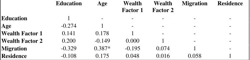
6.8 Correlation Between Socioeconomic Variables
Socioeconomic variables do not demonstrate high levels of inter-correlation. Table 6.4 indicates that length of time a resident has lived in Mahahual (referred to as migration in table 6.4) is correlated with age (p= 0.018). This suggests that Mahahual does not generally attract older migrants. People typically move to Mahahual when they are young. As discussed in section 6.3, fishing is the number one reason that people moved to Mahahual. The methods of fishing employed in Mahahual (discussed in chapter eight) are difficult and may not be actively pursued by older people in search of a new home. Other variables are not correlated and represent independent socioeconomic indicators.
Table 6.4 Correlation Matrix of Socioeconomic Variables
Education Age Wealth
Migration -0.329 0.387* -0.195 0.074 1
-Residence -0.108 0.175 0.048 0.016 0.058 1
CHAPTER 7 SOCIAL STRUCTURE
7.1 Social Stratification and Land Tenure
Mahahual, like most other communities in the world, is economically stratified. Some people have boats, vehicles, and other material possessions that others do not. However, with an increase in tourism this disparity may become greater. For example, a fisherman with a boat is occasionally able to take tourists diving on the coast and to Banco Chinchorro, earning a profit up to 1000 pesos per day (approximately $110 US dollars) compared to 200-500 pesos ($22-56) per day fishing. Tourist day trips to Chinchorro often start after the nets have been retrieved and end before deployment of nets at night, so the boat owner can generate income from both fishing and tourism. If the tourist trip is more than one day, regular crewmembers who do not go out with the tourists would not have the opportunity to fish while the boat is away. Thus, crewmembers can remain economically stagnant while the boat owners are earning increasing amounts of money.
As the disparity in the material style of life among community members increases, social problems could result. Concentration of assets, especially land, can result in augmented social differentiation and impoverishment (Stonich 1992, p. 391). Several informants mentioned that beach access has already begun to manifest itself as a pressing social issue in Mahahual. Several parcels of beachfront land (the land typically owned by residents with higher incomes) have been fenced off and marked as private property, a trend that may continue as more of the coastal land is bought up.
Several residents have also expressed concern about the availability of affordable land in Mahahual. Currently, only 25% of residents have title to their land (personal communication, Dr. F. May. 07/99) Some respondents claim that since Mahahual is targeted for tourism development the government is unwilling to relinquish possession through traditional land tenure systems that turn over title to residents that have occupied land for over five to ten years. One respondent remarked “If they don’t have the security of titles, what kind of life are they going to live? None. You aren’t going to invest in something they are going to take away. The people live here with their houses, sure, but they don’t have the security of the title.”
A representative from the governmental agency in charge of tourism development, Fide Caribe, claims that as part of the Costa Maya project, titles to land will be given to residents that are relocated to K55 (personal communication, Costa Maya representative, 07/99). However, many residents are not interested in being relocated.
7.2 Formal and Informal Associations
The most active and organized associations in Mahahual are the two fishing cooperatives: Banco Chinchorro Cooperative and Langosteros del Caribe, each of which has approximately 30 members. There is also another cooperative that fishes at Banco Chinchorro, the Cooperativa Andres Quintana Roo, but it is based in Xcalak. Many members of the Banco Chinchorro and Langosteros del Caribe cooperatives live in Chetumal and come to Mahahual only to fish.
Lobster and conch are high priced fisheries and are important sources of foreign exchange in the region (Basurto, 1996). Regulations require fishers to be members of cooperatives in order to legally capture and sell these species (Basurto, 1997). Cooperatives are given exclusive rights to fish conch and lobster, as well as exclusive rights to all fishing activities in Banco Chinchorro. Cooperatives are also one of the only avenues open for fishermen (both members and non-members) to obtain loans for the purchase of a boat and/or motor. In Chetumal, members of the Langosteros del Caribe cooperative have also formed an official tourism cooperative called the Paradiso Caribe. Though the tourism cooperative is not active at the moment, a key informant claims that members are looking into obtaining a large boat to transport tourists to Banco Chinchorro.
7.3 Sea Tenure
Cooperatives are awarded exclusive fishing rights for Banco Chinchorro and for the statewide extraction of lobster and conch. The exclusive rights that have been awarded to the cooperatives have been a point of controversy between free fishermen (fishermen not associated with cooperatives) and cooperative members, because free fishermen routinely make illegal fishing trips to Banco Chinchorro. Cooperatives extract all types of species from Banco Chinchorro, but during lobster and conch seasons, harvests are more focused on the species in season. While lobster and conch are harvested by the free fishermen that fish illegally in Chinchorro, the free fisherman’s target species are more commonly fish and shark, thus serious controversy is avoided by minimizing competition for species with exclusive rights. Despite the difference in target species, some cooperative members referred to free fishermen fishing in Chinchorro without permission as “pirates.”
During this research, there were no observations of direct conflicts regarding sea tenure, however, there are several scenarios in which conflicts could manifest. Although resources are currently abundant enough to attract people to the area, there is an overall perception that fishery resources are declining (section 10.2). Intensification of fishing and tourism pressures could lead to a scarcity of both coastal and Banco Chinchorro fishery resources. Leach, Mearns, and Scoones (1999) state “conflicts over access often intensify when the resource in question becomes scarce…” Conflicts may also be exacerbated if the Fide Caribe tourism development displaces free fishermen from their coastal fishing grounds. This may force free fishermen to frequent Banco Chinchorro more often, resulting in more opportunities for conflict.
the harvesting of lobster and conch. A cooperative member claimed that there were as many as 300 fishermen working (legally) in Banco Chinchorro during lobster season, of which only 90 were cooperative members.
7.4 Enforcement of Environmental Regulations
The Secretaria De Medio Ambiente, Recursos Naturales y Pesca (SEMARNAP) is the federal agency responsible for developing and implementing environmental regulations. A branch of SEMARNAP, Procuraduria Federal de Proteccion al Ambiente (PROFEPA), is responsible for the enforcement of environmental regulations. However, PROFEPA has resource limitations and inadequate enforcement personnel [10 rangers in the entire state of Quintana Roo, most of which are located in the northern end of the state (personal communication, SEMARNAP official, 6/99)]; thus, environmental laws are generally not well enforced around Mahahual. However, PROFEPA does have enough of a presence that residents are not blatant about breaking environmental regulations.
The continual presence of army soldiers and marines is a deterrent to some crimes such as illegal hunting and turtle collection, but other regulations go virtually unheeded. For example: some fishermen continued to capture lobster throughout the closed season (March through June). During the closed season lobster production occurs for local consumption, sale to local restaurants, and even sale to market in Chetumal. However, during closed season, capture of lobster is low key, and full-scale production is not instituted by the cooperatives. When questioned about illegal practices, informants often claimed that subsistence capture of lobsters during the closed season is tolerated. Key informants also claim that commercial lobster activities are also tolerated as long as they are not blatantly disregarding the law.
Recently a harbormaster has been placed in Mahahual. His duties include enforcing safety regulations (i.e. making sure that vessels are equipped with the required safety gear and closing the port in bad weather events), making sure that vessel operators have the required licenses, training, and registration, and keeping track of the vessels that are in port. The presence of the harbor master been perceived as a hardship among some fishermen who view him as a limitation to days at sea (by closing the port) and believe the fees, licenses, and safety regulations that he enforces are too expensive and time consuming. However, the harbormaster does provide services such as critical weather information (i.e. sea conditions and port closures) to the fishermen with radios. Unfortunately, the vast majority of fishermen do not have radios (the only radio that was observed was in a fishing camp at Cayo Centro in Banco Chinchorro).
CHAPTER 8
ACTIVITIES IN THE COASTAL ZONE
8.1 Introduction
Most residents in Mahahual depend on coastal resources for their livelihoods. Unfortunately, some means of exploiting coastal resources are not sustainable. A wide array of activities occur around Mahahual that have the potential to alter or affect coastal ecosystems. Activities include: farming, clam (almeja) gathering, black coral harvesting, fishing, tourism and tourism-associated development.
8.2 Farming
8.2.1 Significance of Farming
Farming around Mahahual consists mainly of small-scale, family-run farms and ranches set several kilometers back from the coastline. Farms are typically about 50 hectares, and several houses are on a single plot. Harvests include guano (palm thatch used to make palapa roofs), bananas, watermelon, limes, mangos, peppers, chile peppers, cucumbers, tomatoes, and lemon grass. Most farmers reside in K55, though work may be further inland.
Key informants said that despite the relative abundance of fresh water, the topsoil is relatively thin which creates unfavorable farming conditions. Farming activities are also constrained by the presence of annoying insects. Key informants explained that during June, July, and August the mosquitoes are so bad that they cannot even farm. This was confirmed by observation.
8.2.2 Environmental Impacts of Farming
Farming practices around Mahahual have the potential to adversely impact the environment. Deforestation of forest and possibly mangroves, can increase erosion. Siltation from runoff can be detrimental to coral reefs. Animal feces, agricultural chemicals, and the environmentally insensitive use of pesticides can contaminate groundwater. Fertilizers and animal feces can add excessive nutrients to the ecosystem. Nutrient loading stimulates algal growth which can smother coral reefs.
8.3 Gleaning
8.3.1 Significance of Gleaning
According to Ruddle (1996), gleaning (gathering) is the most widely practiced method of reef species exploitation worldwide. Gleaning occurs mainly on reef flats, seagrass beds, and shores and is simply the manual collection of organisms, usually invertebrates. In southern Quintana Roo, commercial gleaners target almeja, a small white clam. However, subsistence gleaners also target blue and stone crabs, urchins, lobster, and octopus, among others (Basurto, 1997) using hands, machetes, rakes, nets or screens, hooks, and extraction sticks.