UPDATING BUILDING MAPS BASED ON
OBJECT EXTRACTION AND BUILDING HEIGHT ESTIMATION
L. Zhu a, *, H. Shimamura a, K. Tachibana a
a
Research and Development Center, PASCO CORPORATION, Annex 2-8-11 Higashiyama, Meguro-ku, Tokyo
153-0043, Japan - (luihnz7801, hairdu9189, kainka9209)@pasco.co.jp
Commission VII, WG VII/5
KEY WORDS: Aerial, Building, Updating, Change Detection, Object
ABSTRACT:
This study presents a novel approach in building change detection for map updating in urban areas. Our approach is based on the integration of building object extraction and building height estimation utilizing existing 2D building maps and newly-acquired high resolution aerial orthoimages & DSMs. In our proposed scheme, the detection of newly-built buildings is carried out based on building object extraction from orthoimages and DSMs. Detection of demolished and reconstructed buildings is performed based on estimating the height of each building using existing building maps and newly-acquired DSMs. Finally the two results are integrated together for map updating. The experimental results showed that the proposed technique performed satisfactorily well in detecting newly-built buildings, demolished buildings and reconstructed buildings, and was very effective in reducing the problem of misdetection and false detection. This technique is already integrated into a practical system for building maps updating.
* Corresponding author.
1. INTRODUCTION
Automated update of building information in maps from high-resolution aerial imagery is one of the most important and challenging researches in the field of photogrammetry and remote sensing. Up-to-date building information is necessary for many practical applications such as fixed assets inventory, city planning, GIS application analysis, etc. In general, updating of building information is carried out through change detection utilizing orthoimages or both orthoimages and DSMs acquired at two different epochs. However, the orthoimages and DSMs of the previous epoch do not necessarily always exist. In many cases, only 2D building vector maps are available for comparison. Existing approaches for automated update of building information, for instance, feature-based approach or object-based approach, seem to be less accurate and less realizable especially in dense urban areas due to the complexity of urban environments, and quite a lot of challenges remain for practical applications as well. Hence, there is a great demand for development of corresponding new strategies on automated update of 2D or 3D building maps.
This study presents a novel approach in building change detection for map updating in urban areas. Our approach is based on the integration of building object extraction and building height estimation utilizing existing 2D building maps and newly-acquired aerial orthoimages & DSMs. In the proposed scheme, the detection of newly-built buildings is carried out based on building object extraction from newly-acquired orthoimages and DSMs. Detection of demolished and reconstructed buildings is performed based on estimating the height of each building using existing building maps and newly-acquired DSMs. Finally the two results are integrated together for map updating.
The experimental results showed that the proposed approach performed satisfactorily well in detecting newly-built buildings, demolished buildings and reconstructed buildings in the test area. Almost all demolished and reconstructed buildings are detected. Most of the newly-built buildings are detected except for some small ones due to the influence of vegetation surrounding the buildings. This implies the necessity for further improvement of building object extraction. Also, it is shown that the proposed approach is very effective in reducing the problem of misdetection and false detection especially for demolished and reconstructed buildings. Moreover, it is found that the proposed approach can be used to detect the misregistration of building polygons in building maps in which the positional accuracy of building polygons is worse and can be used for accuracy check of building maps. This technique has already been integrated into a practical change detection system for building maps updating in Japan (Zhu et al., 2010).
2. METHODOLOGY OF BUILDING MAP UPDATING
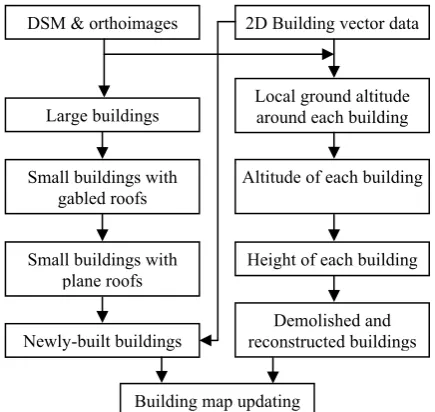
In this study, a hybrid approach is proposed to detect newly-built buildings, demolished and reconstructed buildings respectively by exploiting the information from different kinds of data. Since no orthoimages & DSMs data of the previous epoch is provided for comparison with newly-acquired data, newly-built buildings can not be extracted by using a general change detection method. An alterative way is to extract all building objects from newly-acquired orthoimages & DSMs first, and then, to separate newly-built buildings out from other ones by using an existing building map, i.e. only the building objects at the locations where there were no previous building polygons existed are retained. In contrary to detection of newly-built buildings, detection of demolished and reconstructed
International Archives of the Photogrammetry, Remote Sensing and Spatial Information Sciences, Volume XXXIX-B7, 2012 XXII ISPRS Congress, 25 August – 01 September 2012, Melbourne, Australia
buildings utilizes both the orthoimages & DSMs data of the previous epoch and existing building maps. In many previous researches, change detection is performed mainly by comparing the data of two different epochs at a feature level or object level. For example, extracting linear features like edges or lines from orthoimages and comparing them to building polygons, or extracting building objects from orthoimages & DSMs data and comparing them to building polygons based on calculating an overlapped area percentage. The main difficulty of these methods is that the performance of change detection depends on the correctness and completeness of feature extraction and object extraction, which is not that easy in a dense urban environment like many metropolises. On the other hand, the characteristics of different kinds of data, i.e. building polygon and orthoimages & DSMs can be utilized and the two data can be integrated. It should be noticed that the height of a building is very effective information in order to handle building change. If a building polygon and DSM is available, the ground altitude around the building and also the altitude inside the building polygon can be estimated. Thus, the height of the building at the present epoch can be obtained. If the building is demolished, the obtained height of the building should be very low and can be detected easily. The flow chart of the proposed approach for building map updating is shown in Figure 1.
Figure 1. Flow chart of building map updating
2.1 Detection of newly-built buildings
In this study, newly-built buildings are detected based on building object extraction from newly-acquired orthoimages & DSMs (Zhu et al., 2008). The proposed approach applies a hierarchical strategy to extract large buildings, small buildings with gabled roofs, and small buildings with plane roofs, respectively. First, a Normalized DSM (NDSM) is generated mainly by morphological processing on DSM. Then, large buildings which have large areas and high heights are extracted by simply thresholding the NDSM followed by some morphological processing. After that, small buildings with gabled roofs are extracted by a Local Surface Normal Angle Transform (LSNAT) method through the extraction of roof plane. And then, a Marker Controlled Watershed Segmentation (MCWS) method is applied to extract small buildings with
plane roofs. The final result of building object extraction is acquired by merging the results obtained from above mentioned steps. This result is compared with an existing building map, and newly-built buildings can be separated out from the other ones by retaining the building objects at the locations where there were no building polygons in the existing building map.
2.1.1 Normalized DSM Generation
Morphological operators are used to remove the objects on the ground, like buildings, trees, cars, and others since they are proved to be suitable for such shape processing of these objects. A morphological filter first performs a close operation to fill the pits in the DSM. A close operator dilates the DSM first and erodes it then. After that, the morphological filter performs an open operation to remove the objects such as buildings, trees and cars. The size of morphological element is decided by the size of the maximum object to be removed. Since removing the objects with a large scale element will cause step effects in a DTM, a low pass filter is used to smooth the DTM in order to remove step effects.
Then, the NDSM can be generated by subtracting the DTM from the DSM. The NDSM refers to the ground surface that suppresses the terrain height to an equal level. It gives the real heights of the objects on the ground and can be segmented according to a certain height threshold.
2.1.2 Building extraction using LSNAT method
Large buildings are extracted by thresholding a NDSM directly, and morphologically processed in order to separate the objects connected with each other and to remove some small areas.
From the NDSM, it is found that some buildings are quite small. If a low threshold is simply used to binary them, there will be large non-zero regions composed of several connecting buildings. On the contrary, most buildings can simply be segmented but the small ones will be lost. Therefore, a local surface normal analysis is applied for roof plane extraction in order to extract small buildings with gabled roofs.
In this study, a local quadratic surface least squares method is used to obtain local surface normal vectors. Then the NDSM can be transformed into two normal angles at each grid, which represents the normal vector by directions. Then a 2D histogram of the angles can be generated. The peaks of the 2D histogram will correspond to the directions of concentrated normal vector directions. The building roof grids with the same normal direction will generate a peak in the histogram, and so do other objects and ground grids, etc. By extracting the grids corresponding to specific peaks, the planes corresponding to certain roofs can be detected.
The 2D histogram generates approximately three main peaks. Among the three peaks, the maximum value occurs at the center. It implies that the directions of the normal vectors mostly go upward. They represent the grids of the ground and plane roofs. The other two peaks represent the grids of gabled roofs, respectively.
If a building has a gabled roof, it should show at least a pair of plane. Thus, small buildings with gabled roofs can be detected by counting the numbers of grids corresponding to the two DSM & orthoimages
International Archives of the Photogrammetry, Remote Sensing and Spatial Information Sciences, Volume XXXIX-B7, 2012 XXII ISPRS Congress, 25 August – 01 September 2012, Melbourne, Australia
peaks of the 2D histogram within a watershed region. The ones with grids greater than a certain value are regarded as a building.
2.1.3 Building extraction using MCWS method
Since some small buildings with very small areas, low heights and plane roofs are easily misdetected, the MCWS method, which is an improved method based on general watershed segmentation, is applied.
Watershed segmentation to gray level images is suitable to separate different objects from each others. But it will not give the actual boundaries of each object. The boundary between two objects by watershed segmentation just locates somewhere between them, not exactly the object contour.
Watershed segmentation to gradient image can solve this problem and give a real contour of the object. If we apply watershed segmentation to a gradient image, the catchment basins will be the dark regions of the gradient image, which should theoretically correspond to the homogeneous grey level regions. The watershed segmentation will stop at the contours of the dark objects in the gray level image.
However, in practice, this transform produces an important over-segmentation due to noise or local irregularities in the gradient image. To avoid the over-segmentation, a marker controlled watershed is introduced (Gao et al., 2001, Salembier et al., 1994). Here, the watershed segmentation is implemented to the gradient of NDSM (GNDSM). A marker is an area which is the initial of a catchment basin. By giving each object and the background a marker, and making them the catchment bases, the desired objects can be segmented from the background.
Buildings, trees, and other off-terrain objects are taken as the foreground objects and are assigned the foreground markers. A foreground marker is a spot. If it is the catchment basin for the gradient then the marker will grow to an object. There will be as many objects as foreground markers.
The foreground marker is detected by local maxima. The local maximum of an object may be a spot with certain area as a marker. For the buildings with flat roofs, all the pixels in the roofs will be detected as the local maximums in the ideal case. In practice, most pixels of the roof, especially in the center, will be detected as the marker spot. For some objects, because they have more than one obstruction in the roof, there will be several markers detected and consequently they will be segmented as several objects. This disadvantage can be avoided by merging the large regions with the foreground markers.
The ground of NDSM is taken as the background and is assigned the background marker. Because the watershed of the segmentation of the NDSM generally locates between objects, it is initially taken as the marker of the background. Sometimes the background marker crosses large regions so that these objects will grow to the background. A refined procedure is implemented to maintain these foreground markers.
2.1.4 Extraction of newly-built buildings
The final result of building object extraction can be acquired by merging the results derived by the MCWS method with that of the LSNAT method. Then, newly-built buildings can be detected by overlying the results of extracted buildings on
building map. Newly-built buildings can be detected as extracted building objects where there is no building in the building map.
2.2 Detection of demolished and reconstructed buildings
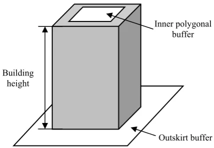
Height information is one of the most important characteristics of the objects on the ground, and shows the status of ground surface. It is also very effective information in order to handle building change, and should be utilized for building change detection. In this study, detection of demolished and reconstructed buildings is performed based on estimating the height of each building using existing building maps and newly-acquired DSMs. Figure 2 shows the illustration of building height estimation. The proposed approach is explained in a step wise procedure below.
Figure 2. Illustration of building height estimation
2.2.1 Estimation of local ground altitude
The first step for building height estimation is to acquire the local ground altitude surrounding each building. Based on the building map data, an outskirt buffer around a building polygon is generated. Then, the minimum height inside the outskirt buffer is explored to acquire the altitude of the local ground area around the building.
2.2.2 Estimation of building altitude
The altitude of each building also needs to be acquired. Considering the uncertainty involving the gap between a building polygon and DSM, and the quality of DSM data at the border of a building, etc., an inner polygonal buffer is created inside the building polygon. Then, the altitude of inner polygonal buffer is acquired by exploring the minimum height of the inner polygonal buffer. This altitude corresponds to the altitude of the building polygon.
2.2.3 Building height estimation
Next, the height of the building can be estimated directly by subtracting the altitude of the building polygon from the ground altitude surrounding the building.
2.2.4 Extraction of demolished and reconstructed buildings Finally, by comparing the building height with a pre-defined threshold, the status of the building, i.e. unchanged, demolished or reconstructed can be detected. If a building is demolished or reconstructed, the obtained building height should be very low hence can be simply detected.
Outskirt buffer Inner polygonal
buffer
Building height
International Archives of the Photogrammetry, Remote Sensing and Spatial Information Sciences, Volume XXXIX-B7, 2012 XXII ISPRS Congress, 25 August – 01 September 2012, Melbourne, Australia
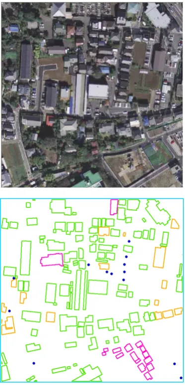
Figure 3. Image and change detection results in a test area (Blue: Newly-built, Pink: Demolished, Orange: Reconstructed)
3. RESULTS
The performance of change detection is assessed by comparing the results obtained by the proposed approach to the reference data acquired from image interpretation at a test area of Tokyo, Japan. A building map of 2004 is used in this study. The aerial images are acquired in 2008 by a multi-line digital airborne sensor ADS40. The orthoimages & DSMs data are generated by the Pixel FactoryTM system of Astrium GEO-Information Services. The resolution of DSMs is 0.5m and that of orthoimages is 0.2m. Figure 3 shows the orthoimage of the test area and change detection results of the proposed approach.
Table 1 shows the details of the change detection results for newly-built buildings, demolished and reconstructed buildings. 39 buildings are detected from 44 changed buildings, and a total detection rate is 88.6%. As for the details, 9 out of 13 newly-built buildings are detected except for some very small ones. All 16 demolished buildings, and 14 out of 15 reconstructed buildings are detected. Among 4 undetected newly-built buildings, 3 of them failed due to the influence of vegetation. This shows the necessity to further improve the ability to remove vegetation influence. On the other hand, detection of
demolished and reconstructed buildings based on building height estimation shows a high detection rate which proves the effectiveness of this method. The proposed hybrid change detection approach shows little misdetection and false-detection, and is able to distinguish reconstructed buildings which are difficult to be detected generally, and is possible to be applied for building detection in the dense urban areas. Moreover, after integrating this technique into a system for practical use, it is found that the proposed approach can be used even to detect the misregistration of building polygons in building maps in which the positional accuracy of building polygons is worse and hence can be used for accuracy check of building maps.
Detailed results
Newly-built Demolished Reconstructed
Changed Buildings 13 16 15
Detected Buildings 9 16 14
Total Accuracy (%) 88.6
Table 1. Detailed results of building change detection
4. CONCLUSIONS
This study presents a novel approach for building map updating in dense urban areas. A scheme is proposed that allows efficient integration of building object extraction and building height estimation for detection of newly-built buildings, demolished and reconstructed buildings, respectively. From the experimental results of performance assessment, the proposed approach presents wonderful results that it can detect almost all demolished and reconstructed buildings, and most newly-built buildings, and is effective to reduce the problems of misdetection and false-detection. Besides, the proposed approach can also be used to detect the misregistration of building polygons in building maps and can be used for accuracy check of building maps. This technique is already integrated into a practical system for building maps updating. Further improvement of this approach should be addressed on building object extraction, especially for very small buildings which are easily affected by surrounding vegetation.
References
Gao, H., Siu, W.C., Hou, C.H., 2001. Improved techniques for automatic image segmentation. IEEE Transactions on Circuits
and Systems for video technology, 11 (12), pp. 1273-1280.
Salembier, P., Pardas, M., 1994. Hierarchical morphological segmentation for image sequence coding. IEEE Transactions on
Image Processing, 3 (5), pp.639-651.
Zhu, L., Shimamura, H., Tachibana, K., Li, Y., Gong, P., 2008. Building change detection based on object extraction in dense urban areas. The International Archives of the Photogrammetry,
Remote Sensing and Spatial Information Sciences, Beijing,
China, Vol. XXXVII, Part 7, pp. 905-908.
Zhu, L., Shimamura, H., Tachibana, K., 2010. Development of building change detection system. Proceedings of Japan Society of Photogrammetry and Remote Sensing (JSPRS) Autumn
conference, October 14-15, Hakodate, Hokkaido, Japan.
International Archives of the Photogrammetry, Remote Sensing and Spatial Information Sciences, Volume XXXIX-B7, 2012 XXII ISPRS Congress, 25 August – 01 September 2012, Melbourne, Australia