THE EFFECT OF LAND USE AND COMMUNITY
PARTICIPATION ON FLOOD CONTROL AT NORTH ACEH
DISTRICT
Wesli
Malikussaleh University Lhokseumawe
Sirojuzilam
Regional Planning Program USU Medan
A Rahim Matondang
Regional Planning Program USU Medan
Suwardi Lubis
Regional Planning Program USU Medan
ABSTRACT
This study is intended to answer the effect of land use, community participation and their relationship to flooding. The result states that land use has a direct effect to flooding with value of about -0.323, all of the land use does not have an indirect effect, therefore the total score is -0.323. Community participation for flood control has a direct effect of about 1.640. The participation does not have an indirect effect, therefore the total effect is 1.640. Community participation has a direct effect to flooding with score of -0.416. The indirect effect is 2.322, while the total effect is 1.906. Land use for flood control has no direct effect and indirect effect. Land use has a direct effect to flood with score of a bout -0.323. It does not have an indirect effect, while the total effect is -0.323. Flood control effect on flooding has a direct effect of 1.416. It does not have indirect effect, thus the total effect is 1.416. The study reveals that the land use and community participation related to flood variables have significant effect. Moreover, flood control effort also has significant effect to reduce flooding.
Keywords: Land use, community participation, flood, flood control
ABSTRAK
Penelitian ini bertujuan untuk menjawab besarnya pengaruh tataguna lahan, partisipasi masyarakat dan hubungan keduanya terhadap banjir. Hasil penelitian menyatakan bahwa tataguna lahan terhadap banjir berpengaruh langsung -0.323, tidak ada pengaruh tak langsung, efek total -0.323, Partisipasi masyarakat terhadap pengendalian banjir berpengaruh langsung 1.640, tidak ada pengaruh tak langsung, efek total 1,640. Partisipasi masyarakat terhadap banjir berpengaruh langsung -0.416, pengaruh tak langsung 2,322, efek total 1,906. Tataguna lahan terhadap pengendalian banjir tidak berpengaruh langsung maupun tak langsung. Tataguna lahan terhadap banjir berpengaruh langsung 0.323, tidak ada pengaruh tak langsung, efek total -0,323. Pengendalian banjir terhadap banjir berpengaruh langsung 1.416, tidak ada pengaruh tak langsung, efek total 1,416. Hasil penelitian menyatakan bahwa tataguna lahan dan partisipasi masyarakat berpengaruh signifikan terhadap banjir. Pengendalian banjir berpengaruh signifikan terhadap banjir.
Kata kunci: Tataguna lahan, Partisipasi masyarakat, Banjir, Pengendalian banjir
INTRODUCTION
North Aceh district is very susceptible to flood hazard. Based on flood risk mapping
by Badan Nasional Penanggulangan
Bencana Pusat (BNPB) [2010], the area as has higher flood risk compared to other districts in Aceh Province. Krueng Keu-reuto is one of the rivers in North Aceh
172 which is currently not able to accommo-date the flowing water from the upstream. Economic losses due to the flooding in the area are estimated to about Rp 60-70 billi-on per year [Bappeda Aceh Utara, 2011]. High frequency of flooding mainly occurs in sub Matangkuli, Lhoksukon, Baktiya, Tanah Pasir and Baktiya Barat. The flood inundation are ranged from 7 -15 days and with the water level of about 60-100 cm. Changes in catchment hydrologic condi-tions also occurred in addition to high rainfall intensity. These changes are gene-rated due to uncontrolled deforestation and inappropriate land use, especially by re-garding to its function. Besides spatial planning by the local governments, there is still no regulation (Perda/Qanun) functi-oned as a legal basis for land use manage-ment. The land use changes in the study area therefore are not planned and become main contributor to the flooding.
Land use can affect flooding especially due to its function as water storage. According to Chow et al., [1988], type of land use and land cover will affect runoff coefficient. Runoff coefficient is one of the variables that affect flooding in addition to rainfall and catchment area. According to He-Fei [2006], Changes in land use, espe-cially increasing urban land use will lead to higher river flow, and makes the risk flooding is also increasing.
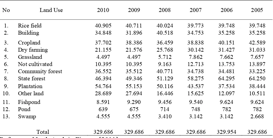
Land use of the district based on reports from North Aceh in Figures (2011) are mainly used for rice field 40.905 Ha (12.41%), building 34,848 Ha (10.57%), cropland 37,702 Ha (11.44%), dry farming area 21,155 Ha (6.42%), grassland 4,497 Ha (1.36%), Land that is not cultivated 10,395 Ha (3.15%), community forest 36,552 Ha, state forest 46,394 Ha (14.07%), plantation 54,764 Ha (16.61%), Other land use 28,689 Ha (8.70%), fish-pond 8,591 Ha (2.61%), fish-pond 639 Ha (0.-19%), and swamp 4,555 Ha (1.38%). Land use conditions in North Aceh changes from year to year, as shown in Table 1,
THE EFFECT OF LAND USE Wesli, Sirojuzilam, A Rohim Matodang, Suwardi Lubis
173 requires the responsibility of multi stake-holders for monitoring and controling through provision of facilities and infra-structures, so that negative impacts can be reduced as much as possible.
An integrated regional planning is required in solving problem related flood hazard. Regional planning that is more focused on economic development planning will go hand in hand with the implementation of community planning and participatory planning. Thus the planning is based on applications of scientific methods in ma-king public policy and attempts to link scientific and technical knowledge into actions inside the community domain to achieve higher social welfare [Sirojuzilam, 2010]. Formulation of the reseach problem in this study is based on the contradiction of the requirements for regional deve-lopment and the effort to minimize the discharge during high-intensity rainfall. To overcome this problem, land use planning optimization is required so that both of them can be linked to reduce flooding. Be-sides, an effort in community participation is necessary as one of the input to stake-holders, especially in conducting
preventi-ve measures against floods and community involvement in water resources manage-ment. The objectives of this research is to explore the effect of land use and community participation on flooding in North Aceh, and measures its effect as a flood control efforts through non-structural approach in regulating land use and to crease community participation, either in-dividually or in groups that can bring re-commendations for local governments in implementing regional development. Hypothesis of the research are:
1. Land use change has a negative impact and is significant to flooding
2. Community participation has a negative impact and is significant to flooding 3. Land use and community participation
have a negative impact and are signifi-cant to flooding
4. Community participation has a positive impact and is significant to flood control
5. Community participation and flood control have a negative impact andare significant to flood
6. Flood control has a negative impact and is significant to flooding
Table 1. Land use Changes at Aceh Utara
No Land Use 2010 2009 2008 2007 2006 2005
1. Rice field 40.905 40.711 40.024 39.773 39.748 39.748 2. Building 34.848 31.896 40.518 34.753 35.258 35.258
3. Cropland 37.702 38.386 36.459 38.838 40.151 42.589 4. Dry farming 21.155 21.576 25.768 30.142 31.427 31.033
5. Grassland 4.497 4.497 5.712 7.862 7.662 7.657
6. Not cultivated 10.395 10.395 9.163 12.713 13.753 13.897 7. Community forest 36.552 35.512 40.771 34.738 34.481 33.225 8. State forest 46.394 49.346 51.129 58.275 64.295 64.250 9. Plantation 54.764 55.153 50.116 43.537 37.534 38.444 10. Other land 28.689 27.694 16.446 15.625 12.097 10.511
11. Fishpond 8.591 9.290 9.456 9.540 9.624 9.624
12. Pond 639 675 714 748 782 782
13. Swamp 4.555 4.555 3.410 3.142 3.142 2.668
174 THE METHODS
Very complex relationship found from varius factors that generate flooding since it involves natural phenomena that often beyond human control. Various types of physical and non-physical mitigation effo-rts, either alone or combined only serves to suppress or minimize the magnitude of the flooding damage. Therefore, it can not eli-minate the problem completely or freeing floodplain from flooding absolutely. Approach to overcome flooding problem with structural mitigation are still required, but must be supported with a non-structu-ral approach in an integrated manner to reduce the impact.
This study merges two variables of land use and community participation combined with civil engineering based research using river conditions, channel and hydrology of the region to compare each variable. The variables are integrated in a formulated model, which is comprehensively counter-measures one to other. Empirical data are used to analyze the civil engineering based data, and the observed variables are inte-grated to both empirical data. The data is analyzed based on latent variables (unob-served) through questionnaire. The ana-lysis is conducted using structural equation model (SEM) in Amos software. Technical empirical data become the basis for deter-mining the extent of forest which then compared with public perception. This stu-dy aims to identify the effect of land use and community participation to flooding. The results are expected to minimize the impact of floods, which can be done by preparing a variety of strategies, especially structural approach synergized with non-structural approach. It therefore can pro-vide an opportunity to community partici-pation, so that optimal results are obtained. Based on above description, the reduction in structural approach has a tendency to-wards required high costs. It is in contrast with local government budget that are
constraints on those aspects. It therefore needs to be done through non-structural strategies involving community approach by relying on the concept of social capital which focusing on trust, networking and social institutions.
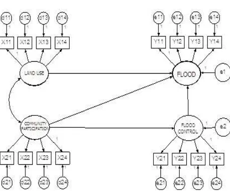
This study uses latent variables (unobser-ved) consists of latent exogenous variables as independent variables and endogenous latent variables as dependent variable. The independent variables are namely land use and community participation. Each varia-ble is measured through indicators mani-fest with the notation x. Endogenous latent variables as the dependent variable are na-mely floods and flood control. Each varia-bles measured through indicators manifest variables y. The conceptual framework can be described as shown in Figure 1, where x11 is the land area, x12 is land conversion,
x13 is land regulation (Qanun), x14 is illegal
logging, x21 is participation of maintained
infrastructure, x22 is money participation,
x23 is participation in planning, x24 is
participation in the implementation, y11 is
water level inundation, y12 is duration of
flood, y13 is coverage of flood, y14 is loss
rate, y21 is floodplain management, y22 is
institution coordination, y23 is disaster
flooding and y24 is infrastructure
mainte-nance.
THE EFFECT OF LAND USE Wesli, Sirojuzilam, A Rohim Matodang, Suwardi Lubis
175 government officials involved in flood management problem (Bappeda, Dinas Pengairan, and Badan Penanggulangan Bencana Daerah/BPBD). Ten people were selected for each institution so the number is 30 samples. Information from the insti-tution will be used as additional informa-tion on instituinforma-tion perceptual aspects. Hydrologic data used are rainfall, river hydraulic, climatology and land use. An analysis of the ability of rivers and cha-nnels to flow the water is also conducted. The analysis results are later used as a comparison against the questionnaire analysis.
Necessary technical data, public percep-tion both individually and in community institutions, perceptions of government officials who have responsibility for the management of water resources were used as informants. The data is required in accordance with the characteristics of the data:
a. Primary data, data collection was done by field observations, through ques-tionnaires and searched documentation b. Secondary data, data collection was
done through compilation of relevant agencies in accordance with the requirements of data
Figure 1. Conceptual Framework Research
176 appropriately. Relationships among the model outlined in the structural equation model and measurement model. Variables in Structural Equation Modeling consist of latent variables as an abstract concept that can only be observed indirectly and imper-fectly through its effect on the observed variables. Latent variables distinguished the exogenous and endogenous variables. Exogenous variables equivalent to the independent variable, while the equivalent endogenous variables with the dependent variable. Observed variables or measured variable is the variable that can be obser-ved or measured empirically and is often referred as an indicator. This variable is a measure of the effects or latent variables. RESULT AND DISCUSSION
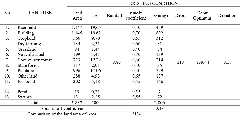
According to Chow et al., [1988] land use is directly proportional to flooding. Land use is converted through runoff coefficient whose magnitude depends on the type of land use. The result of the calculation indicates that the existing land use produce flood discharge 1686.16 m3/sec based on rational methods, while the capacity of the river catchment and drainage based on the hydraulic channel is 946.74 m3/sec. This case illustrates that the Krueng Keureuto
River in this condition is no longer able to drain so that the flood will occur. Discharge runoff of 139.42 m3/sec is shown in Table 2.
To get a balanced condition between land use 42% of the area is required. Table 3 illustrates the condition that the discharge will be balanced.
Goodness of Fit Test
Conformance testing of the used to test how well the level of goodness of fit of the research model. Based on the test results shown in Table 4, it can be seen that all of the existing criteria are in good condition. It can be said that the overall research model has a good level of goodness of fit. Measurement result of goodness-of-fit test indicates that the model proposed in this study can be accepted. It can be seen from the Chi Square and probability value of 112.882 and 0.161 respectively. The value explains that the overall fit of the model can be said to be moderate. However, the analysis can still be conducted, because the size of a model is not only seen from the probability value, but also seen from other fitting criteria, for example GFI, AGFI, CFI, TLI, and RMSEA [Kusnendi, 2008].
Table 2. Comparison of Land Area Against Discharge Runoff
No LAND USE
EXISTING CONDITION
Land
Area % Rainfall
runoff
coefficient Avarage Debit
Debit
Optimum Deviation
1. Rice field 1.147 19,65
8,80
0,40 459
118 109,44 8,17
2. Building 1.145 19,62 0,70 802
3. Cropland 566 9,70 0,55 312
4. Dry farming 135 2,31 0,60 81
5. Grassland 84 1,44 0,40 34
6. Not cultivated 199 3,41 0,70 139
7. Community forest 713 12,22 0,30 214
8. State forest 117 2,01 0,30 35
9. Plantation 996 17,06 0,30 299
10. Other land 288 4,93 0,65 187
11. Fishpond 302 5,18 0,55 166
12. Pond 13 0,21 0,55 7
13. Swamp 131 2,25 0,55 72
Total 5.837 100 2.806
Area runoff coefficient 0,48
THE EFFECT OF LAND USE Wesli, Sirojuzilam, A Rohim Matodang, Suwardi Lubis
177
Table 3. Comparison of Land Area Ballance Condition
No LAND USE
BALLANCE CONDITION Land
Area % Rainfall
runoff
coefficient Avarage Debit
Debit
Optimum Deviation
1. Rice field 1.147 19,65
Normed Chi-square (CMIN/DF) used to measure the suitable indices for relative parsimony goodness-of-fit model. Mo-reover, the coefficients estimated amount is expected to reach the level of con-formance. Value of CMIN/DF in this model is 1.140, indicates that the model fulfilled both the criteria. Goodness-of-Fit Index (GFI), which indicates the level of overall model, was calculated from predicted squared residuals compared to the actual data. Value close to 1 implies that tested model has good agreement. With the acceptance of the recommended level> 0.9, it can be concluded that the research model has a good level of compliance with GFI of 0.962.
Adjusted Goodness-of-Fit Index (AGFI) is
the GFI that is adjusted by the ratio
between the degree of freedom of the proposed model and the degree of freedom of the null models. AGFI value in our model is 0.948, indicates that the model is considered good. Tucker Lewis Index (TLI) is an index that compares the incremental conformance tested model with baseline model. TLI is a suitability index model that is less affected by sample size, with recommended value > 0.9. It can be concluded that the proposed model shows a good level of compliance with TLI value of 0.973. Comparative Fit Index
(CFI) is an index that compares the incremental model with null tested model. The scale of this index ranges from 0 to 1. A value close to 1 indicates that the model has a good level of fitness. This index is highly recommended to use since the index is relatively insensitive to sample size and less effectd by the complexity of the model. Regarding to the recommended resultof > 0.9, the CFI of 0.978 indicates that the model had a good agreement. The Root Mean Square Error of Approximation (RMSEA) is an index used to compensate the value of Chi-Square in a larger sample. Acceptance of the recommended value is < 0.08, RMSEA of 0.020 in this model showed a good level of fitness. Thus it can be said that the overall research model has good goodness-of-fit, so it can be used as an accurate model.
Table 4. Good of Fit Test Criteria
178
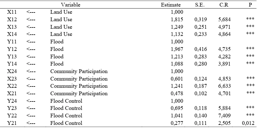
Table 5.Weights Regression on Factors
Variable Estimate S.E. C.R P
X11 <--- Land Use 1,000
X12 <--- Land Use 1,815 0,319 5,684 ***
X13 <--- Land Use 1,249 0,251 4,971 ***
X14 <--- Land Use 1,132 0,233 4,864 ***
Y11 <--- Flood 1,000
Y12 <--- Flood 1,967 0,416 4,735 ***
Y13 <--- Flood 1,213 0,283 4,282 ***
Y14 <--- Flood 1,088 0,280 3,891 ***
X24 <--- Community Participation 1,000
X23 <--- Community Participation 0,601 0,124 4,853 ***
X22 <--- Community Participation 1,241 0,187 6,633 ***
X21 <--- Community Participation 0,478 0,102 4,701 ***
Y24 <--- Flood Control 1,000
Y23 <--- Flood Control 0,695 0,118 5,884 ***
Y22 <--- Flood Control 1,041 0,140 7,409 ***
Y21 <--- Flood Control 0,277 0,111 2,505 0,012
Table 6. Causality test models
Variable Estimate S.E C.R P
Flood Control <--- Community Participation 3,108 1,083 2,870 0,004
Flood <--- Land Use -0,259 0,120 2,169 0,030
Flood <--- Community Participation -0,435 0,216 2,011 0,044
Flood <--- Flood Control -0,782 0,222 3,519 ***
Convergent validity test
Based on the measurement results of Table 5, the regression weights for all indicators critical ratio is greater than two times standard errors. That means all points in the research studies are applicable to each variable.
Causality test models
Regression weights from causality test result or effect between variables can be analyzed and calculated through AMOS statistical program. In addition to the degree of freedom (df), the value of t or cr can also be known, based on the significance of t with probability value (p) = 0.05
Further explanation of regression weights evaluation analysis can be described and explained as follows:
a. Community participation variables sig-nificantly affect flood control because of the significance is 0.004, less than the probability value of 0.05.
b. Variables significantly affect land use variables with significance of 0,030, smaller than the 0.05 probability.
c. Variables significantly affect partici-pation because the significance of 0.044 is smaller than the 0.05 probability. d. Variables significantly affect flood
control variables with significance of 0.00, smaller than smaller than the 0.05 probability.
Hypothesis Testing
THE EFFECT OF LAND USE Wesli, Sirojuzilam, A Rohim Matodang, Suwardi Lubis
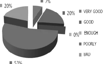
179 made by the increasing to selling price of land, especially for agricultural area loca-ted on the roadside. The change of runoff coefficient and reducing water infiltration into the soil is one of the factors that caus-ing floodcaus-ing. Buildcaus-ing permit (IMB) rules implementation related to the conversion from rice fields to houses or shops illustra-tes that 20% is not good, 53% is poor, 0% is quite good, 20% good and only 7% very good as shown in Figure 2. This informa-tion is in line with the results of the hypo-thesis testing that the conversion of rice fields into residential or shop/commercial is common in North Aceh.
Figure 2. Graph of Building Permit (IMB) Forest land that is not reaching the optimal ratio in North Aceh occurred because of many illegal logging. Based on the results of the questionnaire, 19% is stated that many illegal logging occurred, 41% stated a lot of them are going on, 38% stated they were quite a lot going on and only 2% statetd that they were less. Incidence of illegal logging according to the respon-dents in North Aceh is shown in Figure 3. The regulation of the district as of local regulations in theAceh province is called Qanun. It regulate in detail about the land use including planning permissions that are not disturbing the development. In line with the study by He-Fei [2006] in Shen-zhen, China, there is a real relationship between the impact of changes in land use policies against the risk of flooding to some extent. It stated that changes in land use, particularly the use of urban land,
causing an increase in river flow which makes the risk of flooding increases. Other research by Wesli [2007], states that the flood is stronglyeffected by rainfall and land use regulation. In this study, land use variables have a direct effect of -0.323 to flooding and not have an indirect effect to the flood variables, therefore the total effects is -0.323. Ability of ground water buffer area (community forests, state forests and plantations) indicates that the ratio of the buffer in the existing condition is 31%. Thus it will generate 118 m3/sec temporary discharge, while the river's capacity and drainage water flow is only 109.44 m3/sec. This shows that the capacity of the river is not able to drain flood which still going at 8.17m3/sec. To obtain the equilibrium flow rate based on of rainfall at or near capacity and river draining the ratio of ground water buffer lands (private forests, state forests and plantations) it must have an area appro-ximately 42% of the total area. Based on the above calculation, it can be stated that the ability of forest land as a water buffer, the ratio of land use, regulations governing land use, and indicator of illegal logging contribute in influencing the flood occu-rrence of 0.259, while the rest is affected by other variables
180 involved were excluded. Community parti-cipation in maintaining flood infrastruc-tures causing ignorance of the people, which assume that the task of keeping the flood infrastructures is government's duty. Community involvement in the mainte-nance of flood infrastructures in North Aceh based on respondent data is shown in Figure 4.
Figure 3. Illegal logging in North Aceh Based on respondents
Figure 4. Involvement of communities in flood infrastructure maintenance Community participation is one of the factors lacked by stakeholders. The role of the government is still very dominant. Co-mmunity participation in the pre-disaster phase is very small, especially in the process and policy implementation. The participation rate is only in the level of consultation. In some activities, there are still at the level of information in which the civil society still as objects. In this study, it stated that community partici-pation has a direct effect of -0.416 and
indirect effect of 2.322 to flooding, so the total effect is 1.906. Based on this condi-tion, the community involvement to main-tain flood infrastructure, such as by not throwing waste into the river or channel, cleaning channels, community involve-ment in flood manageinvolve-ment planning, co-mmunity involvement in overseeing the implementation on such infrastructure de-velopment contributes to 0.435, while the rest is affected by other variables.
THE EFFECT OF LAND USE Wesli, Sirojuzilam, A Rohim Matodang, Suwardi Lubis
181 above description it can be stated that the ability of forest land as a water buffer, the ratio of land use, regulations governing land use, and the occurrence of illegal together with community involvement in maintaining the flood infrastructures. Co-mmunity involvement by not throwing waste into the river or canal, community involvement in implementing river clean-ing, community involvement in planning or anticipation of flood mitigation, and public involvement in the implementation of development such as overseeing the construction of flood indrastructure contri-bute to influencing the flood occurrence of floods by 0.020, while the remaining are affected by other variables.
Hypothesis that participation affect flood control is significant and gives positive effect was given by critical ratio (cr) 2.870 which is greater than t table value 1.96 and a P value 0.004 or less 0.05. It can be said that hypothesis acceptable. Loading factor participation to flood control is 3.108, so it can be interpreted that any addition or increase in the value of the participation variable of one unit will increase the value of flood control variable from 3.108. Co-mmunity involvement in maintaining flood infrastructure need to be given sufficient space, especially in the flood control program, such as floodplain management as well as in preventing floods by using communal work (gotong royong), keeping the environment and so forth. Besides, people also need to be involved in the pla-nning and implementation of development related to flood control. In this study, the community participation variables have a direct effect 1.640 and did not have an indirect effect on flood control variable, so the total effect is 1.640. Community in-volvement in maintaining the flood infra-structure by not throwing waste into the river or canal, the involvement of the co-mmunity in providing assistance to per-form mutual cooperation, community in-volvement in the planning or anticipation of flood mitigation, public involvement in
the implementation of development such as overseeing the infrastucture deve-lopment will affect flood control.
182 involvement in providing assistance through mutual aid duct cleaning, co-mmunity involvement in planning or anti-cipation of flood mitigation, public in-volvement in the implementation of deve-lopment such as overseeing the construc-tion of flood infrastructure along with variable water level, duration of inunda-tion, widespread inundation and loss con-tribute to affect flood control at 3.065, while the rest is affected by other variables.
Hypothesis that flood control and flood has a significant positive effect was given by critical ratio value (cr) of 3.519, greater than t table of 1.96. The Probability (P) is 0.000, smaller than 0.05, so the hypothesis can be accepted. Loading factor flood for flood control is -0.782. Based on the research by Tsinda et al., [2010] in the city of Kigali (Rwanda), the result indicates that the city of Kigali is effectd by multiple disasters that caused some damage. From Kigali case, it is implied that the ongoing disaster mitigation is hindered by a se-parate policy and disfunction among sta-keholders involved in disaster manage-ment. The government must make prac-tical policy regarding to flood control as in land-use planning, thus it can prevent the encroachment of the land vulnerable to flooding. This can not be done if people are not empowered with knowledge related to flood, because the community partici-pation in the planning stage by positioning the community as beneficiaries is some-times limited. In the context of Kigali, in-terests of grassroots communities should be given a key role in the planning and implementation together with public institutions. From the results of a study by Motoyoshi [2006], research on the issue of community participation in flood risk management methods using questionnaires
and SEM analysis (structural equaition
model) indicates that the flood control is not related to the community participation and society. Society is basically has a greater desire to participate in
community-based activities such as disaster prepa-redness when they given space to get involved in it. In this study, flood control variables have a direct effect to flood variable of 1.416 and did not have an indirect effect for flood variable. Thus it has a total effect -1.416. Based on the description, it is stated that the importance of an integrated flood control by involving all stakeholders in anticipation of flooding either on pre-disaster, disaster and post-di-saster conditions must conducted through flood plains management (flood manage-ment).
Novelty
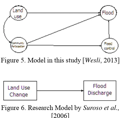
Research and study of flooding has been done by many researchers, but mostly oriented towards technical studies based on empirical data using manifest variables such as rainfall, river cross section (chann-el), land use and other technical variables. Research related to community participa-tion as one of the flood variables in this study illustrate that there is a relationship and effect of each variable to flooding. A finding of the novelty in this study is the model used, that combine two independent variables as land use variables and co-mmunity participation variable for flood control. All of the variables together were analyzed related to flooding as dependent variable. In addition, this study is the first study in North Aceh and Aceh Province which intended to answer the effects of the non-structural efforts in flood control. The model used in this study as shown in Figure 5.
THE EFFECT OF LAND USE Wesli, Sirojuzilam, A Rohim Matodang, Suwardi Lubis
183 Figure 5. Model in this study [Wesli, 2013]
Figure 6. Research Model by Suroso et al., [2006]
In the above model, land-use variable is independent variable and flood discharge variable is the dependent variable. Other studies related to the conclusion is that the change of land use from wetlands to resi-dential and industrial area in Kaligarang cactment area causing increasing discharge and sedimentation, flooding, lower crop area and agricultural production in the lower reaches of the cactment area [Kurnia et al., 2006]. The land use change variables as independent variables and the flood discharge as the dependent variable to the model as shown in Figure 7.
Figure 7. Research Model by Kurnia et. al. [2006]
Other studies of community participation to flooding in the Semarang Lama city re-lated to the conclusion is that the presence of community participation in the financ-ing of operations and maintenance acti-vities at the implementation of the flood control program can be resolved if the implementation can give maximum benefit and impact on economic growth, which is not only in the region but around the area of the Semarang city [Yudho, 2002]. Research using one dependent variable and one independent variable in which
community participation as an independent variable is a latent variable. It is measured by manifest variables, namely participation in maintenance, dues and participation in giving force participation. Flood control as the dependent variable is a latent variable that is measured by manifest variables including flooding duration and frequency of floods. Difference of this study is related to the number of independent variables used, which is only one variable as the participation variable alone. The research model is shown in Figure 8
Figure 8. Research Model by Yudho et. al. [2002]
Another novelty in this research is the use of latent variables that can not be mea-sured directly but through a dimension of indicator variable [Kusnendi, 2008]. In this study, land use variables become inde-pendent variables as latent variable that is measured with manifesting variable, x11,
x12, x13 and x14 and community
parti-cipation variable taken as latent variable, measured by manifesting variables x21, x22,
x23 and x24. Floods and flood control as the
dependent variavel is a latent variable that is measured by manifesting variable y11,
y12, y13 and y14 for flooding, and y21, y22,
y23 and y24 for flood control. Previous
184 regarding flood prevention models in North Aceh district is that it can later be replicated in other areas, as well in the Aceh Province or in Indonesia, or even in other areas where flood control efforts are required in a comprehensive manner thro-ugh structural and non-structural approach. CONCLUSION
Government of the district should make local regulation (Qanun) which regulates the land use and its derivatives as well as the rules governing the use of land, includ-ing rules on land use change and water buffer, planting efforts through community forestry program in order to expand the area of forest, and close monitoring of the illegal logging through firmly law enfo-rcement. In the preparation, it should pay attention to forest area as a water buffer system which is important as an effort to reduce runoff. By maintaining sufficient forest area, it does not necessarily eli-minate flooding, but at least it can reduce the water that becomes runoff
To reduce flood through non-structural approach, community participation both in maintaining the function of flood infra-structure, involved in the planning, and implementation of development in the field flooded is indispensable. To maxi-mize the efforts of non-structural appro-ach, North Aceh District Government must proactively engage the community, espe-cially by considering the communities as subjects and not as objects in flood infra-structure maintenance, flood mitigation planning, implementation of infrastructure, and promotion of the integrated mana-gement. Those actions are important in facing floods, so that they feel owning the infrastructure and wants to maintain it. Non-structural effort by the communities is including setting up disaster aware co-mmunity by forming groups in every vi-llage and conduct training simulations in disaster preparedness. Given the regular floods every year, local authority is
expected to build an early warning infrastructure which is important to reduce the impact of flood, especially casualty losses, evacuation of the casualties, and material losses.
Flood prevention programs through non-structural activities involving the co-mmunity and regulate the land use to re-duce flooding. Government of the district should prepare ‘Qanun’ regulation go-verning the use of land and to prevent the occurrence of illegal logging. This is su-pported with the involvement of the community together to supervise and facilitate in maintaining the infrastructure. This is possibly conductd by not throwing waste into the river or channels, comm-unity involvement in providing assistance such as cleaning rivers and channels. Be-sides, people should be given a space to engage in planning or mitigation of floods and public involvement in the imple-mentation of development such as oversee-ing flood infrastructure construction. To prevent flooding, the government should make land use regulations, which covering prevention of land conversion, especially water buffer areas such as forests, gardens, fields and other.
In addition to the structural measures, the district government should make non-structural efforts through community pro-grams that are more extensive, involving civil society organizations (NGOs), and universities. Involvement in flood control efforts must cover the pre-flood conditi-ons, floods, and the aftermath. The combi-nations of structural and non-structural efforts have been started due to its efficiency.
THE EFFECT OF LAND USE Wesli, Sirojuzilam, A Rohim Matodang, Suwardi Lubis
185 involves stakeholders including commu-nity involvement, both individually and institutionally.
Local government should immediately develop effective floodplain management and applicable strategy, and routine ma-intenance to flood infrastructures. Manage-ment by strengthening inter sectoral
co-ordination in accordance with their respective is also required. Badan Pe-nanggulangan Bencana Daerah (BPBD) should be pointed as proactive coordinator partnering with various parties. Besides BPBD must keep records and evaluate any disasters, including losses due to disasters in order to become a powerful database to resolve problems in the future disasters. REFERENCES
Regional Disaster Management Agency Nort Aceh (2011), Disaster Reports Nort Aceh District, BPBD, Aceh Utara.
National Disaster Management Agency (2010), National Disaster Manage-ment Plan 2010-2014, BNPB, Jakarta.
Regional Planning Board (2011), North Aceh in Figures, The Government of Aceh Utara, Aceh Utara.
Chow, V.T., Maidment, D.R, and Mays, L. W. (1988), Applied Hydrology, Mc Graw Hill Book Company, New York.
He-Fei (2006), Effect of Land Policy Change on Flood Risk in Shenzhen Special Economic Region, College of Resources Science and Techno-logy, Beijing Normal University.
Kodoatie, R. J. (2002), Applied Hydrau-lics, Flow in Open Channels and Pipes, Andi, Yogyakarta.
Kurnia U. et al., (2006), Influence of Land Use Change on Discharge and Flooding in the Downstream Catchment Area Kaligarang, Pusat Penelitian dan Pengembangan Ta-nah dan Agroklimat, Bogor.
Kusnendi, M.S. (2008), Structural Equa-tion Models the Multigroup Model
Samples with Lisrel, Alfabeta, Ba-ndung.
Motoyoshi T. (2006), Public Perception of Flood Risk and Community-based Disaster Preparedness, Journal Terrapub and Nied.
Murase, M., Tyagi-Avinash, C., Saalmu-eller J., and Nagata, T. (2010), Organizing Community Partici-pation for Integrated Flood
Mana-gement, Associated Programme on
Flood Management, Climate and Water Department, World Meteo-rological Organization, Geneva. Murdiono, B. (2007), Public Participation
in Management Planning Resource Damage Water Resources, Sema-rang, Universitas Diponegoro, Pro-gram Pascasarjana Teknik Sipil. Sirojuzilam and Mahali, K. (2010).
Regio-nal: Development, Planning and Economic, USU Press, Medan.
Suroso dan Susanto, H. A. (2006), Effects of Changes in Land Use to Discha-rge Banjaran Watershed Flood, Jurnal Teknik Sipil, 3(2): 75 – 80.
186 Wesli (2007), The relationship Rain and
Runoff to Discharge
Determinati-on, Proceedings the 3rd
Interna-tional Conference on Development
of Aceh (ICDA-3), ISBN:
979-1372-37-4 Malikusaleh University.
Wesli (2008), Urban drainage, Graha Ilmu, Yogyakarta.
Howard, W., and Edward, E. (2009), Land Use Water Management and Future Flood Risk. www.elsevier. com/locate/landusepol.
Toni, W. (2009), Analisis Structural Equation Modeling with Amos, Universitas Atmajaya, Yogyakarta. Yuliarthana, Y. (2002), Public