RE
TI
RE
D
Open Geospatial Consortium, Inc.
OpenGIS® Implementation Specification:
Grid Coverage
Revision 1.00
OpenGIS Project Document 01-004
Release Date: 12 January 2001
Copyright © Open Geospatial Consortium, Inc (2005)
License Agreement
Permission is hereby granted by the Open Geospatial Consortium, ("Licensor"), free of charge and subject to the terms set forth below, to any person obtaining a copy of this Intellectual Property and any associated documentation, to deal in the Intellectual Property without restriction (except as set forth below), including without limitation the rights to implement, use, copy, modify, merge, publish, distribute, and/or sublicense copies of the Intellectual Property, and to permit persons to whom the Intellectual Property is furnished to do so, provided that all copyright notices on the intellectual property are retained intact and that each person to whom the Intellectual Property is furnished agrees to the terms of this Agreement.
If you modify the Intellectual Property, all copies of the modified Intellectual Property must include, in addition to the above copyright notice, a notice that the Intellectual Property includes modifications that have not been approved or adopted by LICENSOR.
THIS LICENSE IS A COPYRIGHT LICENSE ONLY, AND DOES NOT CONVEY ANY RIGHTS UNDER ANY PATENTS THAT MAY BE IN FORCE ANYWHERE IN THE WORLD.
THE INTELLECTUAL PROPERTY IS PROVIDED "AS IS", WITHOUT WARRANTY OF ANY KIND, EXPRESS OR IMPLIED, INCLUDING BUT NOT LIMITED TO THE WARRANTIES OF MERCHANTABILITY, FITNESS FOR A PARTICULAR PURPOSE, AND NONINFRINGEMENT OF THIRD PARTY RIGHTS. THE COPYRIGHT HOLDER OR HOLDERS INCLUDED IN THIS NOTICE DO NOT WARRANT THAT THE FUNCTIONS CONTAINED IN THE INTELLECTUAL PROPERTY WILL MEET YOUR REQUIREMENTS OR THAT THE OPERATION OF THE INTELLECTUAL PROPERTY WILL BE UNINTERRUPTED OR ERROR FREE. ANY USE OF THE INTELLECTUAL PROPERTY SHALL BE MADE ENTIRELY AT THE USER’S OWN RISK. IN NO EVENT SHALL THE COPYRIGHT HOLDER OR ANY CONTRIBUTOR OF INTELLECTUAL PROPERTY RIGHTS TO THE INTELLECTUAL PROPERTY BE LIABLE FOR ANY CLAIM, OR ANY DIRECT, SPECIAL, INDIRECT OR CONSEQUENTIAL DAMAGES, OR ANY DAMAGES WHATSOEVER RESULTING FROM ANY ALLEGED INFRINGEMENT OR ANY LOSS OF USE, DATA OR PROFITS, WHETHER IN AN ACTION OF CONTRACT, NEGLIGENCE OR UNDER ANY OTHER LEGAL THEORY, ARISING OUT OF OR IN CONNECTION WITH THE IMPLEMENTATION, USE, COMMERCIALIZATION OR PERFORMANCE OF THIS INTELLECTUAL PROPERTY.
This license is effective until terminated. You may terminate it at any time by destroying the Intellectual Property together with all copies in any form. The license will also terminate if you fail to comply with any term or condition of this Agreement. Except as provided in the following sentence, no such termination of this license shall require the termination of any third party end-user sublicense to the Intellectual Property which is in force as of the date of notice of such termination. In addition, should the Intellectual Property, or the operation of the Intellectual Property, infringe, or in LICENSOR’s sole opinion be likely to infringe, any patent, copyright, trademark or other right of a third party, you agree that LICENSOR, in its sole discretion, may terminate this license without any compensation or liability to you, your licensees or any other party. You agree upon termination of any kind to destroy or cause to be destroyed the Intellectual Property together with all copies in any form, whether held by you or by any third party.
Except as contained in this notice, the name of LICENSOR or of any other holder of a copyright in all or part of the Intellectual Property shall not be used in advertising or otherwise to promote the sale, use or other dealings in this Intellectual Property without prior written authorization of LICENSOR or such copyright holder. LICENSOR is and shall at all times be the sole entity that may authorize you or any third party to use certification marks, trademarks or other special designations to indicate compliance with any LICENSOR standards or specifications.
This Agreement is governed by the laws of the Commonwealth of Massachusetts. The application to this Agreement of the United Nations Convention on Contracts for the International Sale of Goods is hereby expressly excluded. In the event any provision of this Agreement shall be deemed unenforceable, void or invalid, such provision shall be modified so as to make it valid and enforceable, and as so modified the entire Agreement shall remain in full force and effect. No decision, action or inaction by LICENSOR shall be construed to be a waiver of any rights or remedies available to it.
RE
TI
RE
D
TABLE OF CONTENTS
TABLE OF CONTENTS _____________________________________________________________ 3 TABLE OF FIGURES _______________________________________________________________ 8
0.0 PREFACE _______________________________________________________________ 9
0.1 SUBMITTING COMPANIES ____________________________________________________ 9 0.2 SUBMISSION CONTACT POINTS ______________________________________________ 9 0.3 DOCUMENT CONVENTIONS __________________________________________________ 9 0.4 REVISION HISTORY _________________________________________________________ 10 0.5 EDITORIAL NOTES__________________________________________________________ 10 0.6 CHANGES TO THE ABSTRACT SPECIFICATION _______________________________ 10 0.7 DEPENDENCIES ON OTHER OGC SPECIFICATIONS ___________________________ 10
1 SPECIFICATION
OVERVIEW_______________________________________________ 10
2
ARCHITECTURE _________________________________________________________ 11
2.1 Grid Coverages _______________________________________________________________ 11 2.1.1 Grid Coverage Characteristics_______________________________________________________ 11 2.1.2 Grid Coordinate System____________________________________________________________ 12 2.1.3 Grid Coverage Tiling ______________________________________________________________ 12 2.1.4 Color Palettes_____________________________________________________________________ 12 2.1.5 Interoperability___________________________________________________________________ 12 2.2 CV_Coverage ________________________________________________________________ 13 2.3 GC_GridCoverage ____________________________________________________________ 14 2.4 GC_CoverageExchange ________________________________________________________ 15 2.5 GP_GridAnalysis (optional) ____________________________________________________ 16 2.6 GP_GridCoverageProcessor (optional) ___________________________________________ 17 2.7 Interfaces Supporting Coverage (CV) Package _____________________________________ 18 2.7.1 CV_SampleDimension _____________________________________________________________ 18 2.8 Interfaces/Datatypes Supporting Grid Coverage (GC) Package_______________________ 18 2.8.1 GC_GridPacking__________________________________________________________________ 18 2.8.2 GC_GridGeometry________________________________________________________________ 18 2.8.3 GC_GridRange___________________________________________________________________ 18 2.8.4 GC_ParameterInfo________________________________________________________________ 18 2.8.5 GC_Parameter____________________________________________________________________ 18 2.8.6 GC_Format______________________________________________________________________ 18 2.9 Interfaces Supporting Grid Coverage Processing (GP) Package ______________________ 18 2.9.1 GP_Operation____________________________________________________________________ 18
3 COMPONENT SERVICES ____________________________________________________ 19
RE
TI
RE
D
RE
TI
RE
D
RE
TI
RE
D
3.1.8.1.1 Attributes ____________________________________________________________________ 49 3.1.8.1.1.1 +name : CharacterString ______________________________________________________ 49 3.1.8.1.1.2 +description : CharacterString__________________________________________________ 49 3.1.8.1.1.3 +vendor : CharacterString _____________________________________________________ 49 3.1.8.1.1.4 +docURL : String ___________________________________________________________ 49 3.1.8.1.1.5 +version : String ____________________________________________________________ 49 3.1.8.1.1.6 +numSources : Integer _______________________________________________________ 49 3.1.8.1.1.7 +numParameters : Integer _____________________________________________________ 50 3.1.8.1.2 getParameterInfo______________________________________________________________ 50 3.2 Well-known Binary Representations _____________________________________________ 50
3.2.1 WKBGeoTIFF____________________________________________________________________ 50
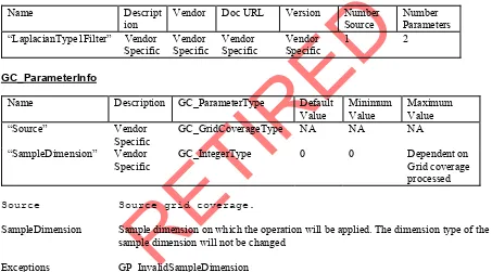
3.3 GP_GridCoverageProcessor Operations __________________________________________ 51 3.3.1 Gray Scale Threshold _________________________________________________________________ 52 3.3.2 Image Enhancements__________________________________________________________________ 52 3.3.2.1 Linear Enhancement_______________________________________________________________ 53 3.3.2.2 Root Enhancement ________________________________________________________________ 53 3.3.2.3 Equalization Enhancement__________________________________________________________ 54 3.3.2.4 Infrequency Enhancement__________________________________________________________ 55 3.3.3 Interpolate___________________________________________________________________________ 55 3.3.4 Band Ratioing________________________________________________________________________ 56 3.3.5 Spatial Filtering______________________________________________________________________ 57 3.3.5.1 Mean Filter ______________________________________________________________________ 57 3.3.5.2 Mode Filter ______________________________________________________________________ 58 3.3.5.3 Median Filter_____________________________________________________________________ 59 3.3.5.4 Gausian Filter____________________________________________________________________ 60 3.3.5.5 LaplacianType 1 Filter_____________________________________________________________ 61 3.3.5.6 Laplacian Type 2 Filter_____________________________________________________________ 61 3.3.6 Select Sample Dimensions______________________________________________________________ 62 3.3.7 Resample____________________________________________________________________________ 63 3.3.8 Sequence____________________________________________________________________________ 64 3.3.9 Density Slice_________________________________________________________________________ 65
4 REFERENCES ____________________________________________________________ 65
APPENDICES ________________________________________________________________ 66
A.1 GLOSSARY OF TERMS ______________________________________________________ 66 A.2 SUPPORTING WELL-KNOWN VALUES________________________________________ 66 A.3 EXCEPTIONS, ERRORS AND ERROR CODES __________________________________ 67 Specific Exceptions___________________________________________________________________ 67 A.4 CONVERSION RULES FOR GRID VALUES TO SPECIFIC DATA TYPES __________ 67 Conversion of Value to Boolean _________________________________________________________ 67 Conversion of Value to 2 bit integer ______________________________________________________ 67 Conversion of Value to 4 bit integer ______________________________________________________ 67 Conversion of Value to Unsigned Character (0 to 255) _______________________________________ 68 Conversion of Value to Signed Character (-128 to 127) _______________________________________ 68 A.5 COM IDL SPECIFICATION ___________________________________________________ 68 A.6 CORBA IDL SPECIFICATION _________________________________________________ 69 A.7 SPECIFICATION SEQUENCE DIAGRAMS _____________________________________ 69
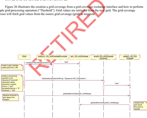
A.7.1 SIMPLE GRID COVERAGE CREATION EXAMPLE__________________________________ 69
RE
TI
RE
D
A.8 VISUAL BASIC SAMPLE CODE _______________________________________________ 70
RE
TI
RE
D
TABLE OF FIGURES
RE
TI
RE
D
0.0 PREFACE
This implementation specification refers to The Open GIS Abstract Specification Topic 6: The Coverage Type and it’s Subtypes, the project document 99-106.
0.1 SUBMITTING COMPANIES
The following companies submitted this implementation specification, in response to the OGC Request Number 5 Core Task Force Working Group A Request For Proposals: Access to Open GIS Coverages, OpenGIS Project Document Number 98-007r1.
• Computer Aided Development Corporation Ltd (Cadcorp)
• Environmental Systems Research Institute (ESRI)
• Intergraph Corporation
• Laser-Scan, Ltd.
• Oracle
• PCI Geomatics Inc
0.2 SUBMISSION CONTACT POINTS
All questions regarding this submission should be directed to:
Louis Burry PCI Geomatics
490 St. Joseph Blvd., Suite 400 Hull, Quebec, Canada, J8Y 3Y7 [email protected]
Adam Gawne-Cain Cadcorp Ltd 4 Fitzroy Square London, UK W1P 5AH [email protected]
John Herring Oracle Corporation 196 vanBuren Street Herndon, Virginia 20170 [email protected]
0.3 DOCUMENT CONVENTIONS
This submission adheres to OGC conventions for UML modeling and CORBA IDL. The COM IDL has followed the Microsoft guidelines for naming conventions since applications will mix OGC/Non-OGC interfaces. The main difference between the OGC and Microsoft conventions is OGC uses a lower case for the first letter for attributes and operations while Microsoft uses upper case.
RE
TI
RE
D
Prefix Package
CV Coverage
GC Grid Coverage
GP Grid Coverage Processing
0.4 REVISION HISTORY 0.5 EDITORIAL NOTES
This specification focuses on grid coverages but effort has been made to ensure generic interfaces and components have been specified at the coverage level for future extensions to other coverage types.
The Essential Model for Grid Coverages lists seven varieties of simple pixel modifications. This submission addresses a subset of these. Radiometric Correction Services and Noise Removal Services have a range of complexities and should be addressed by Image Exploitation SIG
0.6 CHANGES TO THE ABSTRACT SPECIFICATION
To allow for other georeferencing methods, the GridMatrixValue class was modified. The members of the class which described the georeferencing of the grid, were moved into another class. This change from the abstract specification allows for support of non- orthorectified grids.
The sequential enumeration methods for accessing grid matrix values were limited to row dominant, column dominant and band order. Morton order and pyramid sequences were not addressed. Pyramid sequence was perceived to be an association of lower resolution grid coverages to the grid coverage. This is addressed as overviews in the submission.
0.7 DEPENDENCIES ON OTHER OGC SPECIFICATIONS
The specification uses interfaces from the Open GIS Coordinate Transformation specification.
The following packages are used:
Prefix Package
PT Positioning
CS Coordinate Systems
CT Coordinate Transforms
Components from the CT and CS package provide the georeferencing information for the grid coverage. The georeferencing include the projection and the mapping of grid to projection coordinate for the grid..
1 SPECIFICATION OVERVIEW
This implementation specification was drafted with the following goals:
• Allow for a range of implementations. This will allow for relatively quick and easy implementations of the specification to more comprehensive ones.
RE
TI
RE
D
• This specification is written as a general specification with COM and CORBA implementations in mind. This specification could later be extended to include other Distributed Computing Platforms (DCPs) such as JAVA.
• Any implementations of this specification should support creation of coverages from a GeoTIFF raster. GeoTIFF is becoming an industry standard and this is meant to allow for standard test datasets to ensure implementations conform to the specification.
• The specification must allow for efficient access to very large datasets. Datasets can be up to several gigabytes in size.
• Support N dimensions even though most implementations of the specification will be 2 D.
• Extensible framework for image processing and analysis.
• Be able to handle a wide range of grid data from raw to thematically classified grid coverages.
• Support a variety of color models.
2 ARCHITECTURE
The architecture of the grid coverage specification is composed of three packages as shown in Figure 1. The specification includes a package for the general coverage specification (CV), a package specifically for grid coverages (GC) and a package for grid coverage processing (GP). The GP package is optional and not required for an OGC compliant implementation.
CV + CV_ColorInt erpretation + CV_Palet teInterpre tation + CV_SampleDimensionTyp e
Figure 1: Specification Packages
2.1 Grid Coverages
2.1.1 Grid Coverage Characteristics
This Grid Coverage Implementation specification can accommodate grid coverages with the following characteristics:
• Variable number of bits per grid value (bits per pixel).
1, 2, 4 unsigned integer
8, 16, 32 signed, unsigned integer
32, 64 Real
• 1 to N number of bands
• 1 to N dimensions
• For grids with multiple bands, band values can be ordered by dimension. For example, a 2 D grid coverage can be ordered row, column, band (pixel interleaved), row, band, column (line interleaved) or band, row, column (band sequential).
• Support for a variable number of “no data values”
RE
TI
RE
D
• Support of overviews or pyramids (reduced resolution data sets).
2.1.2 Grid Coordinate System
A grid coverage has a grid coordinate system which allows for addressing individual cells in the grid. Individual cells are centered on the grid points. A grid has an ordering of cell values with the first cell in this ordering having a grid coordinate of 0, 0. A two dimensional grid coverage with 512 rows and 512 columns would have grid coordinates with a range from 0 to 511 rows and 0 to 511 columns.
The gridRange attribute in the GC_GridGeometry structure defines the grid coordinate range.
The number of cells in a dimension of the grid can be calculated as grid range maximum – minimum
2.1.3 Grid Coverage Tiling
This implementation specification has no explicit interfaces to retrieve data values from a grid coverage in tiles. It is expected that the implementation will efficiently retrieve data values when the client implementation retrieves data values on tile boundaries. The optimal size to access a dimension can be determined from the GC_GridCoverage optimumDataBlockSizes attribute
2.1.4 Color Palettes
A coverage can have a color palette. A color palette is valid for only coverages which are integer values (usually bytes). Color palettes supported include gray scale, RGB, HSL and CMYK. The coverage dimension information maps the grid sample dimensions to a color palette or to color model components. For example 8-bit pseudo color TIFF image would be represented as a grid with one sample dimension and a color palette with 256 RGB entries. A 24-bit RGB TIFF file would be represented as a grid with three bands and no color palette. The dimension information would indicate which bands to use for the RGB color components. The following illustrates example values for different color components:
Gray Scale Vector contains one entry which a shade of gray. 0 is black and 255 is white.
RGB Vector contains three values: Red Green Blue. Each value ranges from 0 to 255 where 0 is no intensity and 255 is maximum intensity.
RGBA Vector contains four values RGBA: Red Green Blue Alpha. The alpha value is the level of transparency of the color. Alpha of 0 is transparent and 255 is opaque
HSL Vector contains three values: Hue Saturation Lightness. Hue is a value from 0 to 360. Saturation is a value from 0 to 100 where 0 is no color intensity and 100 is full color intensity. Lightness is a value from 0 to 100 where 0 is no lightness and 100 is full lightness.
CMYK Vector contains four values: Cyan Magenta Yellow Black. Each value ranges from 0 to 255 where 0 is no intensity and 255 is maximum intensity.
2.1.5 Interoperability
RE
TI
RE
D
In particular, the following interfaces are assumed to be backed by immutable objects:
CV_SampleDimension, GC_Format, GC_GridCoverageExchange, GP_Operation, GP_GridAnalysis, GP_GridCoverageProcessor
In a GC_GridCoverage, only the cell values may change. The size, geometry, interpolation, sequencing etc should never change. However, clients should be aware that the Grid Coverage object behind the GC_GridCoverage interface may be adapted from other GC_GridCoverage interfaces, so changing the grid point (pixel) values through one GC_GridCoverage could change the grid point values in others. To allow client applications to anticipate adapted Grid Coverages being changed indirectly, the source Grid Geometry object(s) for adapted Grid Geometry objects can be traced.
2.2 CV_Coverage
Abstract interface providing access to an OpenGIS coverage.
The essential property of coverage is to be able to generate a value for any point within its domain. How coverage is represented internally is not a concern. For example consider the following different internal representations of coverage:
1. A coverage may be represented by a set of polygons which exhaustively tile a plane (that is each point on the plane falls in precisely one polygon). The value returned by the coverage for a point is the value of an attribute of the polygon that contains the point.
2. A coverage may be represented by a grid of values. The value returned by the coverage for a point is that of the grid value whose location is nearest the point.
3. Coverage may be represented by a mathematical function. The value returned by the coverage for a point is just the return value of the function when supplied the coordinates of the point as arguments.
4. Coverage may be represented by combination of these. For example, coverage may be represented by a combination of mathematical functions valid over a set of polynomials.
RE
TI
RE
D
CV_SampleDimension + categoryNames : Sequence<CharacterString> + colorInterpretation : CV_ColorInterpretation + description : CharacterString + minimumValue : Number + maximumValue : Number + nodataValue : Sequence<Number> + paletteInterpretation : CV_PaletteInterpretation + palette : Sequence2D<Integer>
+ sampleDimensionType : CV_SampleDimensionType + units : CS_Unit
+ valueOffset : Double + valueScale : Double
+ metadataNames : Sequence<CharacterString> + getMetadataValue(name : CharacterString) : CharacterString
<<Interface>> CV_Coverage
+ numSampleDimensions : Integer + dimensionNames : Sequence<CharacterString> + numSources : Integer
+ coordinateSystem : CS_CoordinateSystem + envelope : PT_Envelope
+ getSampleDimension(index : Integer) : CV_SampleDimension + getSource(index : Integer) : CV_Coverage
+ metadataNames : Sequence<CharacterString>
+ getMetadataValue(name : CharacterString) : CharacterString + evaluate(pt : PT_CoordinatePoint) : Sequence<Number> + evaluateAsBoolean(pt : PT_CoordinatePoint) : Sequence<Boolean> + evaluateAsByte(pt : PT_CoordinatePoint) : Sequence<byte> + evaluateAsInteger(pt : PT_CoordinatePoint) : Sequence<Integer> + evaluateAsDouble(pt : PT_CoordinatePoint) : Sequence<Double>
<<Interface>> + CV_16BIT_U : Integer = 5 + CV_16BIT_S : Integer = 6 + CV_32BIT_U : Integer = 7 + CV_32BIT_S : Integer = 8 + CV_32BIT_REAL : Integer = 9 + CV_64BIT_REAL : Integer = 10
<<CodeList>>
+ CV_Undefined : Integer = 0 + CV_GrayIndex : Integer = 1 + CV_PaletteIndex : Integer = 2 + CV_RedBand : Integer = 3 + CV_GreenBand : Integer = 4 + CV_BlueBand : Integer = 5 + CV_AlphaBand : Integer = 6 + CV_HueBand : Integer = 7 + CV_SaturationBand : Integer = 8 + CV_LightnessBand : Integer = 9 + CV_CyanBand : Integer = 10 + CV_MagentaBand : Integer = 11 + CV_YellowBand : Integer = 12 + CV_BlackBand : Integer = 13
<<CodeList>>
Figure 2: CV_Coverage Package.
2.3 GC_GridCoverage
RE
TI
RE
D
GC_GridCoverageExchange + numFormats : Integer
+ metadataNames : Sequence<CharacterString> + getMetadataValue(name : CharacterString) :
+ createFromName(name : CharacterString) : GC_GridCoverage + listSubNames(name : CharacterString) : Sequence<CharacterString>
+ createFromSubName(name : CharacterString, subName : CharacterString) : GC_GridCoverage + getFormat(index : Integer) : GC_Format
+ exportTo(gridCoverage : GC_GridCoverage, format : CharacterString, name : CharacterString, parameters : Sequence<GC_Parameter>) : void + move(gridCoverage : GC_GridCoverage, coordsys : CS_CoordinateSystem, gridToCoordinateSystem : CT_MathTransform) : GC_GridCoverage
<<Interface>>
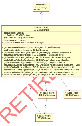
GC_GridCoverage + dataEditable : Boolean
+ gridPacking : GC_GridPacking + gridGeometry : GC_GridGeometry + numOverviews : Integer
+ optimumDataBlockSizes : Sequence<Integer>
+ getOverviewGridGeometry(index : Integer) : GC_GridGeometry + getOverview(index : Integer) : GC_GridCoverage
+ getDataBlockAsBoolean(gridRange : GC_GridRange) : Sequence<Boolean> + getDataBlockAsByte(gridRange : GC_GridRange) : Sequence<byte> + getDataBlockAsInteger(gridRange : GC_GridRange) : Sequence<Integer> + getDataBlockAsDouble(gridRange : GC_GridRange) : Sequence<Double> + getPackedDataBlock(gridRange : GC_GridRange) : Sequence<byte>
+ setDataBlockAsBoolean(gridRange : GC_GridRange, val : Sequence<Boolean>) : void + setDataBlockAsByte(gridRange : GC_GridRange, val : Sequence<byte>) : void + setDataBlockAsInteger(gridRange : GC_GridRange, val : Sequence<Integer>) : void + setDataBlockAsDouble(gridRange : GC_GridRange, val : Sequence<Double>) : void + setPackedDataBlock(gridRange : GC_GridRange, val : Sequence<byte>) : void
<<Interface>> GC_Format
+ name : CharacterString + description : CharacterString + vendor : CharacterString + docURL : CharacterString + version : CharacterString + numParameters : Integer
+ getParameterInfo(index : Integer) : GC_ParameterInfo <<Interface>>
GC_ParameterInfo + name : CharacterString + description : CharacterString + defaultValue : Number + minimumValue : Number + maximumValue : Number
<<Data Type>>
GC_Parameter + name : CharacterString + value : Number
<<Data Type>>
GC_GridRange + lo : Sequence<Integer> + hi : Sequence<Integer>
<<Data Type>>
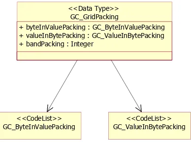
GC_GridPacking
+ byteInValuePacking : GC_ByteInValuePacking + valueInBytePacking : GC_ValueInBytePacking + bandPacking : Integer
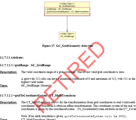
<<Data Type>> GC_GridGeometry
+ gridRange : GC_GridRange
+ gridToCoordinateSystem : CT_MathTransform <<Data Type>>
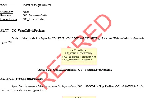
GC_ValueInBytePacking + GC_LoBitFirst : Integer = 0 + GC_HiBitFirst : Integer = 1
<<CodeList>> GC_ByteInValuePacking
+ GC_wkbXDR : Integer = 0 + GC_wkbNDR : Integer = 1
<<CodeList>>
Figure 3: GC_GridCoverage Package.
2.4 GC_CoverageExchange
RE
TI
RE
D
GC_GridCoverageExchange + numFormats : Integer
+ metadataNames : Sequence<CharacterString>
+ getMetadataValue(name : CharacterString) : CharacterString + createFromName(name : CharacterString) : GC_GridCoverage + listSubNames(name : CharacterString) : Sequence<CharacterString>
+ createFromSubName(name : CharacterString, subName : CharacterString) : GC_GridCoverage + getFormat(index : Integer) : GC_Format
+ exportTo(gridCoverage : GC_GridCoverage, format : CharacterString, name : CharacterString, parameters : Sequence<GC_Parameter>) : void + move(gridCoverage : GC_GridCoverage, coordsys : CS_CoordinateSystem, gridToCoordinateSystem : CT_MathTransform) : GC_GridCoverage
<<Interface>>
Figure 4: GC_GridCoverageExchange Interface and its relationships
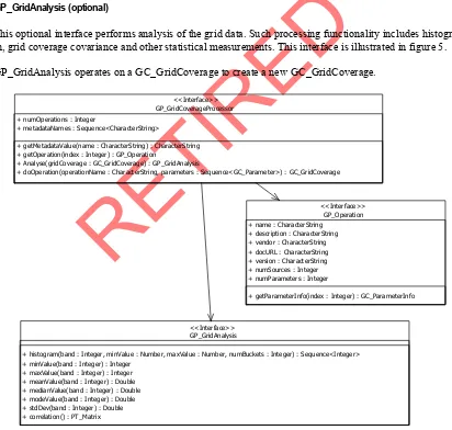
2.5 GP_GridAnalysis (optional)
This optional interface performs analysis of the grid data. Such processing functionality includes histogram calculation, grid coverage covariance and other statistical measurements. This interface is illustrated in figure 5.
GP_GridAnalysis operates on a GC_GridCoverage to create a new GC_GridCoverage.
GP_Operation + name : CharacterString
+ description : CharacterString + vendor : CharacterString + docURL : CharacterString + version : CharacterString + numSources : Integer + numParameters : Integer
+ getParameterInfo(index : Integer) : GC_ParameterInfo <<Interface>>
GP_GridCoverageProcessor + numOperations : Integer
+ metadataNames : Sequence<CharacterString>
+ getMetadataValue(name : CharacterString) : CharacterString + getOperation(index : Integer) : GP_Operation
+ Analyse(gridCoverage : GC_GridCoverage) : GP_GridAnalysis
+ doOperation(operationName : CharacterString, parameters : Sequence<GC_Parameter>) : GC_GridCoverage <<Interface>>
GP_GridAnalysis
+ histogram(band : Integer, minValue : Number, maxValue : Number, numBuckets : Integer) : Sequence<Integer> + minValue(band : Integer) : Integer
+ maxValue(band : Integer) : Integer + meanValue(band : Integer) : Double + medianValue(band : Integer) : Double + modeValue(band : Integer) : Double + stdDev(band : Integer) : Double + correlation() : PT_Matrix
<<Interface>>
RE
TI
RE
D
2.6 GP_GridCoverageProcessor (optional)
This optional interface provides operations for different ways of accessing the grid coverage values as well as image processing functionality. The list of available processing operations is implementation dependent. The interface has a discovery mechanism to determine the available processing operations. This is shown in figure 6.
GP_GridCoverageProcessor + numOperations : Integer
+ metadataNames : Sequence<CharacterString>
+ getMetadataValue(name : CharacterString) : CharacterString + getOperation(index : Integer) : GP_Operation
+ Analyse(gridCoverage : GC_GridCoverage) : GP_GridAnalysis
+ doOperation(operationName : CharacterString, parameters : Sequence<GC_Parameter>) : GC_GridCoverage <<Interface>>
GP_Operation <<Interface>> GP_GridAnalysis
<<Interface>> GC_GridCoverage
(from GC) <<Interface>>
GC_Parameter (from GC)
<<Data Type>>
Figure 6: GP_GridCoverageProcessor Interface discovery mechanism.
These processing operations will transform values within a single sample dimension, and leave the values in other sample dimensions unaffected. The modified sample dimension may also change its type (e.g. from CV_4BIT to CV_1BIT). The actual underlying grid data remains unchanged.
The interface has been designed to allow the adaptations to be done in a “pipe-lined” manner. The interface operates on GC_GridCoverage to create new a GC_GridCoverage. The interface does not need to make a copy of the source grid data. Instead, it can return a grid coverage object which applies the adaptations on the original grid coverage whenever a block of data is requested. In this way, a pipeline of several grid coverages can be constructed cheaply.
This interface can perform any of the following:
Change the number of bands being accessed.
Change the value sequencing in which the grid values are retrieved.
Allow re-sampling of the grid coverage for a different geometry. Creating a new GC_GridCoverage with different grid geometry allows for reprojecting the grid coverage to another projection and another georeferencing type, resampling to another cell resolution and subsetting the grid coverage. Modify the way the grid values are accessed (filtered, classified…).
Change the interpolation method used when evaluating points which fall between grid cells. Filtering
RE
TI
RE
D
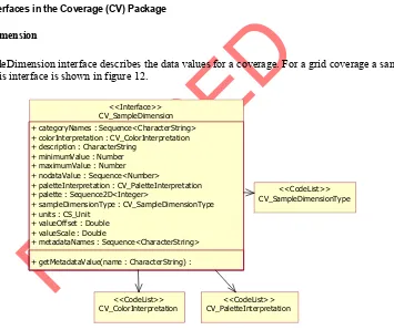
2.7 Interfaces Supporting Coverage (CV) Package 2.7.1 CV_SampleDimension
This interface contains information for an individual sample dimension of coverage. This interface is applicable to any coverage type. For grid coverages, the sample dimension refers to an individual band.
2.8 Interfaces/Datatypes Supporting Grid Coverage (GC) Package 2.8.1 GC_GridPacking
This datatype describes the packing of data values within grid coverages. It includes the packing scheme of data values with less then 8 bits per value within a byte, byte packing (Little Endian / Big Endian) for values with more than 8 bits and the packing of the values within the dimensions.
2.8.2 GC_GridGeometry
This datatype describes the geometry and georeferencing information of the grid coverage. The grid range attribute determines the valid grid coordinates and allows for calculation of grid size. See 2.1.2 Grid Coordinate System for more details. A grid coverage may or may not have georeferencing.
2.8.3 GC_GridRange
This datatype specifies the range of valid coordinates for each dimension of the coverage.
2.8.4 GC_ParameterInfo
This datatype provides information for the parameters required for grid coverage processing operations and grid exchange. This information includes such information as the name of the parameter, parameter description, parameter type etc.
2.8.5 GC_Parameter
This datatype for a parameter required for grid coverage processing operations and grid exchange. The parameter contains the parameter keyword and it’s value.
2.8.6 GC_Format
This interface is a discovery mechanism to determine the formats supported by a GC_GridCoverageExchange implementation. A GC_GridCoverageExchange implementation can support a number of file format or resources.
2.9 Interfaces Supporting Grid Coverage Processing (GP) Package 2.9.1 GP_Operation
RE
TI
RE
D
3 COMPONENT SERVICES
3.1 GRID CONPONENTS CLASSES AND INTERFACES 3.1.1 CV_Coverage
This interface is common to all coverage types. Other coverage types are subtypes of coverage. This interface is shown in figure 7.
CV_Coverage + numSampleDimensions : Integer
+ dimensionNames : Sequence<CharacterString> + numSources : Integer
+ coordinateSystem : CS_CoordinateSystem + envelope : PT_Envelope
+ getSampleDimension(index : Integer) : CV_SampleDimension + getSource(index : Integer) : CV_Coverage
+ getMetadataValue(name : CharacterString) :
+ evaluate(pt : PT_CoordinatePoint) : Sequence<Number> + evaluateAsBoolean(pt : PT_CoordinatePoint) : Sequence<Boolean> + evaluateAsByte(pt : PT_CoordinatePoint) : Sequence<byte> + evaluateAsInteger(pt : PT_CoordinatePoint) : Sequence<Integer> + evaluateAsDouble(pt : PT_CoordinatePoint) : Sequence<Double>
<<Interface>>
GC_GridCoverage (from GC)
<<Interface>> +metaDataNames : Sequence<CharacterString>
Figure 7: CV_Coverage interface for generic coverages.
3.1.1.1 Attributes
3.1.1.1.1 +numSampleDimensions : Integer
Description: The number of sample dimensions in the coverage. For grid coverages, a sample dimension
is a band.
Type: Integer {frozen}
3.1.1.1.2 +dimensionNames : Sequence<CharacterString>
Description: The names of each dimension in the coverage. Typically these names are “x”, “y”, “z” and
“t”. The number of items in the sequence is the number of dimensions in the coverage. Grid coverages are typically 2D (x, y) while other coverages may be 3D (x, y, z) or 4D (x, y, z, t). The number of dimensions of the coverage is the number of entries in the list of dimension names.
RE
TI
RE
D
3.1.1.1.3 +numSource : Integer
Description: Number of grid coverages which the grid coverage was derived from. This implementation
specification does not include interfaces for creating collections of coverages therefore this value will usually be one indicating an adapted grid coverage, or zero indicating a raw grid coverage.
Type: Integer {frozen}
3.1.1.1.4 +metadataNames : Sequence <CharacterString>
Description: List of metadata keywords for a coverage. If no metadata is available, the sequence will be
empty.
Type: Sequence<CharacterString> {frozen}
3.1.1.1.5 +coordinateSystem : CS_CoordinateSystem
Description: This specifies the coordinate system used when accessing a coverage or grid coverage with
the “evaluate” methods. It is also the coordinate system of the coordinates used with the math transform (see GC_GridGeometry attribute - gridToCoordinateSystem:
CT_MathTransform). This coordinate system is usually different than the grid coordinate system of the grid. A grid coverage can be accessed (re-projected) with new coordinate system with the GP_GridCoverageProcessor component. In this case, a new instance of a grid coverage is created.
Note: If a coverage does not have an associated coordinate system, coordinateSystem will be NULL. The gridToCoordinateSystem attribute for GC_GridGeometry should also be NULL if coordinateSystem is NULL.
Type: CS_CoordinateSystem {frozen}
3.1.1.1.6 +envelope : PT_Envelope
Description: The bounding box for the coverage domain in coordinate system coordinates
For grid coverages, the grid cells are centered on each grid coordinate. The envelope for a 2-D grid coverage includes the following corner positions.
(Minimum row - 0.5, Minimum column - 0.5) for the minimum coordinates (Maximum row - 0.5, Maximum column - 0.5) for the maximum coordinates
Note: If a grid coverage does not have any associated coordinate system, the minimum and maximum coordinate points for the envelope will be empty sequences.
Type: PT_Envelope {frozen}
3.1.1.2 getSampleDimension
Prototype: getSampleDimension(index : Integer) : CV_SampleDimension
Class: CV_Coverage
Description: Retrieve Sample dimension information for the coverage. For a grid coverage, a sample dimension is
RE
TI
RE
D
(bit, byte, integer…), the no data values, minimum and maximum values and a color table if one is associated with the dimension. A coverage must have at least one sample dimension.
Inputs:
index Index for sample dimension to retrieve. Indices are numbered 0 to (n-1).
OutPuts: None
Returns: CV_SampleDimension
Exceptions: CV_InvalidIndex
3.1.1.3 getSource
Prototype: getSource(sourceDataIndex : Integer) : GC_GridCoverage
Class: CV_Coverage
Description: Returns the source data for a grid coverage. . If the GC_GridCoverage was produced from an
underlying dataset (by createFromName() or createFromSubName for instance) the NumSource property should be zero, and this method should not be called. If the GC_GridCoverage was
produced using GP_GridCoverageProcessor then it should return the source grid coverage of the one used as input to GP_GridCoverageProcessor. In general the source() method is intended to return the original GC_GridCoverage on which it depends. This is intended to allow applications to establish what GC_GridCoverages will be affected when others are updated, as well as to trace back to the "raw data".
Inputs:
sourceDataIndex Source grid coverage index. Indexes start at 0.
OutPuts: None
Returns: GC_GridCoverage
Exceptions: CV_InvalidIndex
3.1.1.4 getMetadataValue
Prototype: getMetadataValue(name : CharacterString) : CharacterString
Class: CV_Coverage
Description: Retrieve the metadata value for a given metadata name.
Inputs:
name Metadata keyword for which to retrieve metadata.
OutPuts: None
Returns: CharacterString
Exceptions: CV_MetadataNameNotFound
3.1.1.5 evaluate
Prototype: evaluate(point : PT_CoordinatePoint) : Vector
Class: CV_Coverage
Description: Return the value vector for a given point in the coverage. A value for each sample dimension is
RE
TI
RE
D
Inputs:
point Point at which to find the grid values.
OutPuts: None
Returns: Vector
Exceptions: CV_PointOutsideCoverage
3.1.1.6 evaluateAsBoolean
Prototype: evaluateAsBoolean(point : PT_CoordinatePoint) : Sequence<Boolean>
Class: CV_Coverage
Description: Return a sequence of Boolean values for a given point in the coverage. A value for each sample
dimension is included in the sequence. The default interpolation type used when accessing grid values for points which fall between grid cells is nearest neighbor. . The coordinate system of the point is the same as the grid coverage coordinate system.
For converting a value to Boolean, see APPENDICE 5 CONVERSION RULES FOR VALUES TO LANGUAGE SPECIFIC DATA TYPES.
Parameters
point Point at which to find the coverage values.
OutPuts: None
Returns: Sequence<Boolean>
Exceptions: CV_PointOutsideCoverage
3.1.1.7 evaluateAsByte
Prototype: evaluateAsByte(point : PT_CoordinatePoint) : Sequence<Byte>
Class: CV_Coverage
Description: Return a sequence of unsigned byte values for a given point in the coverage. A value for each sample
dimension is included in the sequence. The default interpolation type used when accessing grid values for points which fall between grid cells is nearest neighbor. . The coordinate system of the point is the same as the grid coverage coordinate system.
For converting a value to Byte, see APPENDICE 5 CONVERSION RULES FOR VALUES TO LANGUAGE SPECIFIC DATA TYPES.
For integral values which have less than 8 bits, values are padded to 8 bits.
Inputs:
point Point at which to find the coverage values.
OutPuts: None
Returns: Sequence<Byte>
Exceptions CV_PointOutsideCoverage
3.1.1.8 evaluateAsInteger
RE
TI
RE
D
Class: CV_Coverage
Description: Return a sequence of integer values for a given point in the coverage. A value for each sample
dimension is included in the sequence. The default interpolation type used when accessing grid values for points which fall between grid cells is nearest neighbor. . The coordinate system of the point is the same as the grid coverage coordinate system.
For converting a value to Integer, see APPENDICE 5 CONVERSION RULES FOR VALUES TO LANGUAGE SPECIFIC DATA TYPES.
For integral values which have less than 32 bits, values are padded to 32 bits.
Inputs:
point Point at which to find the grid values.
OutPuts: None
Returns: Sequence<Integer>
Exceptions: CV_PointOutsideCoverage
3.1.1.9 evaluateAsDouble
Prototype: evaluateAsDouble(point : PT_CoordinatePoint) : Sequence<Double>
Class: CV_Coverage
Description: Return an sequence of double values for a given point in the coverage. A value for each sample
dimension is included in the sequence. The default interpolation type used when accessing grid values for points which fall between grid cells is nearest neighbor. . The coordinate system of the point is the same as the grid coverage coordinate system.
For converting a value (v) to double (d), see APPENDICE 5 CONVERSION RULES FOR GRID VALUES TO LANGUAGE SPECIFIC DATA TYPES.
Inputs:
point Point at which to find the grid values.
OutPuts: None
Returns: Sequence<Double>
Exceptions: CV_PointOutsideCoverage
3.1.2 GC_GridCoverage
RE
TI
RE
D
GC_GridCoverage + dataEditable : Boolean
+ gridPacking : GC_GridPacking + gridGeome try : GC_Grid Geome try + numOverviews : Intege r
+ opt imumDataBlockSizes : Se quence< Integer>
+ get Overview GridGe omet ry(index : Integer) : GC_GridGeometry + get Overview (inde x : Intege r) : GC_GridCoverage
+ get DataBloc kAsBoo lean(grid Range : GC_GridRang e) : Sequence<Boo lean> + get DataBloc kAsByte(gridRange : GC_GridRange) : Sequenc e<byte> + get DataBloc kAsInteger(gridRange : GC_GridRange) : Sequenc e<Inte ger> + get DataBloc kAsDoub le( gridRan ge : GC_GridRange) : Sequ ence<Double> + get PackedDataBloc k(gridRange : GC_GridRange) : Sequenc e<b yte>
+ setDataBlockAsBoolean(gridRange : GC_GridRange, val : Sequence <Bo olean>) : void + setDataBlockAsByte( gridRan ge : GC_GridRange, val : Sequenc e<byte>) : void + setDataBlockAsInte ger( gridRang e : GC_Grid Range, val : Sequenc e<Integer> ) : void + setDataBlockAsDo uble(gridRange : GC_GridRange , val : Seq uence<Double>) : void + setPac kedDataBlock(gridRange : GC_Grid Range, val : Sequenc e<byte> ) : void
<<Interface>>
GC_GridPacking <<Dat a Type>> GC_GridGeometry
<<Data Type>>
GC_GridRange <<Dat a Type>> CV_Coverage (from C V)
<<Interfac e>>
Figure 8: GC_GridCoverage interface providing access to grid data values.
3.1.2.1 Attributes
3.1.2.1.1 +dataEditable : Boolean
Description: True if grid data can be edited.
RE
TI
RE
D
3.1.2.1.2 +gridPacking : GC_GridPacking
Description: Information for the packing of grid coverage values.
Type: GC_GridPacking {frozen}
3.1.2.1.3 +gridGeometry : GC_GridGeometry
Description: Information for the grid coverage geometry. Grid geometry includes the valid range of grid
coordinates and the georeferencing.
Type: GC_GridGeometry {frozen}
3.1.2.1.4 +numOverviews : Integer
Description: Number of predetermined overviews for the grid.
Type: Integer {frozen}
3.1.2.1.5 +optimalDataBlockSizes : Sequence<Integer>
Description: Optimal size to use for each dimension when accessing grid values. These values together give the
optimal block size to use when retrieving grid coverage values. For example, a client application can achieve better performance for a 2-D grid coverage by reading blocks of 128 by 128 if the grid is “tiled” into blocks of this size. The sequence is ordered by dimension.
Note: If the implementation does not have optimal sizes the sequence will be empty.
Type: Sequence<Integer> {frozen}
3.1.2.2 getOverviewGridGeometry
Prototype: getOverviewGridGeometry(overviewIndex : Integer) : GC_GridGeometry
Class: GC_GridCoverage
Description: Return the grid geometry for an overview.
Inputs:
overviewIndex Overview index for which to retrieve grid geometry. Indices start at 0.
OutPuts: None
Returns: GC_GridGeometry
Exceptions: GC_InvalidIndex
3.1.2.3 getOverview
Prototype: getOverview(overviewIndex : Integer) : GC_GridCoverage
Class: GC_GridCoverage
Description: Returns a pre-calculated overview for a grid coverage. The overview indices are numbered from 0 to
RE
TI
RE
D
The overviews are ordered from highest (index 0) to lowest (numberOverviews – 1) resolution. Overview grid coverages will have overviews which are the overviews for the grid coverage with lower resolution than the overview.
For example:
A 1 meter grid coverage with 3, 9, and 27 meter overviews will be ordered as follows:
Index resolution
0 3 1 9 2 27
The 3 meter overview will have 2 overviews as follows:
Index resolution 0 9 1 27
overviewIndex Index of grid coverage overview to retrieve. Indexes start at 0.
OutPuts: None
Returns: GC_GridCoverage
Exceptions GC_InvalidIndex
3.1.2.4 getDataBlockAsXXX
Prototype: getDataBlockAsBoolean(gridRange : GC_GridRange) : Sequence<Boolean>
getDataBlockAsByte(gridRange : GC_GridRange) : Sequence<Byte>
getDataBlockAsInteger(gridRange : GC_GridRange) : Sequence<Integer> getValueBlockAsDouble(gridRange : GC_GridRange) : Sequence<Double>
Class: GC_GridCoverage
Description: Return a sequence of strongly typed values for a block. A value for each sample dimension will be
returned.
For CORBA, the sequencing order of the values in the sequence will follow the rules defined in bandPacking GC_GridPacking.
For COM, the return value is an N + 1 dimensional safe-array, with dimensions (sample dimension, dimension n, dimension n-1, … dimension 1). For 2 dimensional grid coverages, this safe array will be
accessed as (sample dimension, column, row). The index values will be based from 0. The indices in the returned N Dimensional safe array will need to be offset by gridRange minimum coordinates to get equivalent grid coordinates.
The requested grid range must satisfy the following rules for each dimension of the grid coverage:
Min grid coordinate <= grid range mimimun <= grid range maximum <= maximum grid coordinate
The number of values returned will equal:
(Max1 – Min1 + 1) * (Max2 – Min2 + 1)… * (Maxn – Minn + 1) * numberSampleDimensions
RE
TI
RE
D
N is the number of dimensions in the grid coverage
Inputs:
gridRange Grid range for block of data to be accessed.
OutPuts: None
Returns: Sequence<XXX>
Exceptions: GC_InvalidRange
3.1.2.5 getPackedDataBlock
Prototype: getPackedDataBlock(gridRange : GC_GridRange) : Sequence<Byte>
Class: GC_GridCoverage
Description: Return a block of grid coverage data for all sample dimensions. A value for each sample dimension
will be returned. This operation provides efficient access of the grid values. The sequencing order of the values in the sequence will follow the rules given by valueInBytePacking and bandPacking defined in GC_GridPacking.
The requested grid range must satisfy the following rules for each dimension of the grid coverage:
Min grid coordinate <= grid range minimum <= grid range maximum <= maximum grid coordinate
The sequence of bytes returned will match the data type of the dimension. For example, a grid with one 16 bit unsigned (CV_16BIT_U) sample dimension will return 2 bytes for every cell in the block.
Byte padding Rules for grid values of less than 8 bits
For 2 D grid coverages, padding is to the nearest byte for the following cases
For PixelInterleaved For grids with multiple sample dimensions, padding occurs between pixels for each change in dimension type.
For LineInterleaved Padding occurs at the end of each row or column (depending on the valueSequence of the grid).
For BandSequencial Padding occurs at the end of every sample dimension.
For grid values smaller than 8 bits, their order within each byte is given by the valueInBytePacking defined in GC_GridPacking.
For grid values bigger than 8 bits, the order of their bytes is given by the byteInValuePacking defined in GC_GridPacking.
Inputs:
gridRange Grid range for block of data to be accessed.
OutPuts: None
Returns: Sequence<Byte>
RE
TI
RE
D
3.1.2.6 setDataBlockAsXXX
Prototype: setDataBlockAsBoolean(gridRange : GC_GridRange, values :
Sequence<Boolean>): Null
setDataBlockAsByte(gridRange : GC_GridRange, values : Sequence<Byte>): Null
setDataBlockAsInteger(gridRange : GC_GridRange, values : Sequence<Integer>) : Null
setDataBlockAsDouble(gridRange : GC_GridRange, values : Sequence<Double>) : Null
Class: GC_GridCoverage
Description: Set a block of strongly typed values for all sample dimensions.
The requested grid range must satisfy the following rules for each dimension of the grid coverage:
Min grid coordinate <= grid range minimum <= grid range maximum <= maximum grid coordinate
The number of values must equal:
(Max1 – Min1 + 1) * (Max2 – Min2 + 1)… * (Maxn – Minn + 1) * numberSampleDimensions
Where Min is the mimium ordinate in the grid range Max is the maximum ordinate in the grid range N is the number of dimensions in the grid coverage
Inputs:
gridRange Grid range for block of data to be accessed.
values Sequence of grid values for the given region.
OutPuts: None
Returns: Null
Exceptions: GC_InvalidRange
GC_GridNotEditable
3.1.2.7 setPackedDataBlock
Prototype: setPackedDataBlock(gridRange : GC_GridRange, values :
Sequence<Byte>) : Null
Class: GC_GridCoverage
Description: Set a block of grid coverage data for all sample dimensions. See GetDataBlock for details on how to
pack the values.
The requested grid range must satisfy the following rules for each dimension of the grid coverage:
Min grid coordinate <= grid range minimum <= grid range maximum <= maximum grid coordinate
For byte padding rules see getDataBlock.
Inputs:
RE
TI
RE
D
values Sequence of grid values for the given region.
OutPuts: None
Returns: None
Exceptions: GC_InvalidRange
GC_GridNotEditable
3.1.3 GC_GridCoverageExchange
The GC_GridCoverageExchange creates instances of grid coverages and can export grid coverage to persistent file formats. This interface is illustrated in figure 9.
GC_GridCoverageExchange + numFormats : Integer
+ metadataNames : Sequence<CharacterString>
+ getMetadataValue(name : CharacterString) : CharacterString + createFromName(name : CharacterString) : GC_GridCoverage + listSubNames(name : CharacterString) : Sequence<CharacterString>
+ createFromSubName(name : CharacterString, subName : CharacterString) : GC_GridCoverage + getFormat(index : Integer) : GC_Format
+ exportTo(gridCoverage : GC_GridCoverage, format : CharacterString, name : CharacterString, parameters : Sequence<GC_Parameter>) : void + move(gridCoverage : GC_GridCoverage, coordsys : CS_CoordinateSystem, gridToCoordinateSystem : CT_MathTransform) : GC_GridCoverage
<<Interface>>
GC_GridCoverage <<Interface>> GC_Format
<<Interface>>
GC_Parameter <<Data Type>>
Figure 9: GC_GridCoverageExchange Interface.
3.1.3.1 Attributes
3.1.3.1.1 +numFormats : Integer
Description: The number of formats supported by the GC_GridCoverageExchange.
Type: Integer {frozen}
3.1.3.1.2 +metadataNames : Sequence<CharacterString>
Description: List of metadata keywords for the interface. If no metadata is available, the sequnce will be empty.
Type: Sequence<CharacterString> {frozen}
3.1.3.2 getFormat
Prototype: getFormat(index : integer) : GC_Format
Class: GC_GridCoverageExchange
Description: Retrieve information on file formats or resources available with the GC_GridCoverageExchange
implementation. Indices start at zero.
Inputs:
RE
TI
RE
D
OutPuts: None
Returns: GC_Format
Exceptions: GC_InvalidIndex
3.1.3.3 getMetadataValue
Prototype: getMetadataValue(name : CharacterString) : CharacterString
Class: GC_GridCoverageExchange
Description: Retrieve the metadata value for a given metadata name.
Inputs:
name Metadata keyword for which to retrieve metadata.
OutPuts: None
Returns: CharacterString
Exceptions GC_MetadataNameNotFound
3.1.3.4 createFromName
Prototype: createFromName(name : CharacterString) : GC_GridCoverage
Class: GC_GridCoverageExchange
Description: Create a new GC_GridCoverage from a grid coverage file. This method is meant to allow
implementations to create a GC_GridCoverage from any file format. A implementation can support nay number of formats which is determined from the GC_Format interface.
Inputs:
name File name (including path) from which to create a grid coverage interface.. This file name can be any valid file name within the underlying operating system of the server or a valid string, such as a URL which specifics a grid coverage. Each implementation must determine if file name is valid for it’s own use.
OutPuts: None
Returns: GC_GridCoverage
Exceptions: GC_CannotCreateGridCoverage
3.1.3.5 listSubNames
Prototype: listSubNames(name : CharacterString) : Sequence<CharacterString>
Class: GC_GridCoverageExchange
Description: Retrieve the list of grid coverages contained within the given file or resource. Each grid can have a
different coordinate system, number of dimensions and grid geometry.
For example, a HDF-EOS file (GRID.HDF) contains 6 grid coverages each having a different projection.
GRID.HDF:____ UTM
RE
TI
RE
D
Note: An empty sequence will be returned if no sub names exist.
Inputs:
name File name (including path) from which to retrieve the grid coverage names .. This file name can be any valid file name within the underlying operating system of the server or a valid string, such as a URL which specifics a grid coverage. Each implementation must determine if file name is valid for it’s own use. Implementations can support many different of file formats
OutPuts: None
Returns: Sequence<CharacterString>
Exceptions: None
3.1.3.6 createFromSubName
Prototype: createFromSubName(name : CharacterString, subName : CharacterString)
: GC_GridCoverage
Class: GC_GridCoverageExchange
Description: Create a new GC_GridCoverage from a file where the file contains many grid coverages. This
method is meant to allow implementations to create a GC_GridCoverage from any file format which contains many grid coverages. An example of such a format is HDF-EOS format.
Inputs:
name File name (including path) from which to create a grid coverage interface.. This file name can be any valid file name within the underlying operating system of the server or a valid string, such as a URL which specifics a grid coverage. Each implementation must determine if name is valid for it’s own use.
subName Name of grid coverage contained in file name or resource.
OutPuts: None
Returns: GC_GridCoverage
Exceptions: GC_CannotCreateGridCoverage
3.1.3.7 exportTo
Prototype: exportTo(gridCoverage : GC_GridCoverage, fileFormat :
CharacterString, fileName : CharacterString, creationOptions : Sequence<GC_Parameter>) : Null
Class: GC_GridCoverageExchange
Description: Export a grid coverage to a persistent file format.
Inputs:
gridCoverage Source grid coverage.
fileFormat String which indicates exported file format. The file format types are implementation specific. The file format name is determined from the GC_Format interface.
Sample file formats include:
“GeoTIFF” - GeoTIFF
“PIX” - PCI Geomatics PIX
“HDF-EOS” - NASA HDF-EOS
“NITF” - National Image Transfer Format
RE
TI
RE
D
Other file format names are implementation dependent.
fileName File name to store grid coverage. This file name can be any valid file name within the underlying operating system of the server.
createOptions Options to use for creating the file. These options are implementation specific are the valid options is determined from the GC_Format interface.
OutPuts: None
Returns: Null
Exceptions: GC_FileFormatNotCompatiableWithGridCoverage
GC_ErrorExportingGridCoverage GC_InvalidParameterName GC_InvalidParameterValue
3.1.3.8 move
Prototype: move(gridCoverage : GC_GridCoverage, coordsys : CS_CoordinateSystem,
gridToCoordinateSystem : CT_MathTransform) : GC_GridCoverage
Class: GC_GridCoverageExchange
Description: Create a new coverage with a different coordinate reference system.
Inputs:
gridCoverage Source grid coverage.
coordsys Coordinate system of the new grid coverage.
gridToCoordinateSystem Math transform to assign to grid coverage.
OutPuts: None
Returns: GC_GridCoverage
Exceptions: None
3.1.4 GP_GridAnalysis
The GP_GridAnalysis interface performs various analysis operations on a grid coverage. This interface is shown in figure 10.
GP_GridAnalysis
+ histogram(band : Integer, minValue : Number, maxValue : Number, numBuckets : Integer) : Sequence<Integer> + minValue(band : Integer) : Integer
+ maxValue(band : Integer) : Integer + meanValue(band : Integer) : Double + medianValue(band : Integer) : Double + modeValue(band : Integer) : Double + stdDev(band : Integer) : Double + correlation() : PT_Matrix
<<Interface>>
RE
TI
RE
D
3.1.4.1 histrogram
Prototype: histogram(sampleDimension : Integer, minimumEntryValue : Number,
maximumEntryValue : Number, numberEntries : Integer) : Sequence<Integer>
Class: GP_GridAnalysis
Description: Determine the histogram of the grid values for a sample dimension.
Inputs:
sampleDimension Index of sample dimension to be histogrammed..
miniumEntryValue Minimum value stored in the first histogram entry.
maximumEntryValue Maximum value stored in the last histogram entry.
numberEntries Number of entries in the histogram.
OutPuts: None
Returns: Sequence<Integer>
Exceptions: GP_InvalidSampleDimension
3.1.4.2 minValue
Prototype: minValue(sampleDimension : Integer) : Number
Class: GP_GridAnalysis
Description: Determine the minimum grid value for a sample dimension.
Inputs:
sampleDimension Index of sample dimension.
OutPuts: None
Returns: Number
Exceptions: GP_InvalidSampleDimension
3.1.4.3 maxValue
Prototype: maxValue(sampleDimension : Integer) : Number
Class: GP_GridAnalysis
Description: Determine the maximum grid value for a sample dimension.
Inputs:
sampleDimension Index of sample dimension.
OutPuts: None
Returns: Number
RE
TI
RE
D
3.1.4.4 meanValue
Prototype: meanValue(sampleDimension : Integer) : Double
Class: GP_GridAnalysis
Description: Determine the mean grid value for a sample dimension.
Inputs:
sampleDimension Index of sample dimension.
OutPuts: None
Returns: Double
Exceptions: GP_InvalidSampleDimension
3.1.4.5 medianValue
Prototype: medianValue(sampleDimension : Integer) : Number
Class: GP_GridAnalysis
Description: Determine the median grid value for a sample dimension.
Inputs:
sampleDimension Index of sample dimension.
OutPuts: None
Returns: Number
Exceptions: GP_InvalidSampleDimension
3.1.4.6 modeValue
Prototype: modeValue(sampleDimension : Integer) : Number
Class: GP_GridAnalysis
Description: Determine the mode grid value for a sample dimension.
Inputs:
sampleDimension Index of sample dimension.
OutPuts: None
Returns: Number
Exceptions: GP_InvalidSampleDimension
3.1.4.7 stdDev
Prototype: stdDev(sampleDimension : Integer) : Double
Class: GP_GridAnalysis
Description: Determine the standard deviation from the mean of the grid values for a sample dimension.
Inputs:
sampleDimension Index of sample dimension.
OutPuts: None
Returns: Double
RE
TI
RE
D
3.1.4.8 correlation
Prototype: correlation() : PT_Matrix
Class: GP_GridAnalysis
Description: Determine the correlation between sample dimensions in the grid.
Inputs:
None
OutPuts: None
Returns: PT_Matrix
Exceptions: GP_GridCoverageHasOnlyOneSampleDimension
3.1.5 GP_GridCoverageProcessor
The GP_GridCoverageProcessor allows for different ways of accessing the grid coverage values. This interface is shown in figure 11.
GP_GridCoverageProcessor
+ numOperations : Integer
+ metadataNames : Sequence<CharacterString>
+ getMetadataValue(name : CharacterString) : CharacterString + getOperation(index : Integer) : GP_Operation
+ Analyse(gridCoverage : GC_GridCoverage) : GP_GridAnalysis
+ doOperation(operationName : CharacterString, parameters : Sequence<GC_Parameter>) : GC_GridCoverage <<Interface>>
GP_Operation <<Interface>> GP_GridAnalysis
<<Interface>> GC_GridCoverage
(from GC) <<Interface>>
GC_Parameter (from GC)
<<Data Type>>
Figure 11: GP_GridCoverageProcessor for performing operations in grid coverages.
Using one of these operations to change the way the grid is being accessed will not affect the state of the grid coverage controlled by another operations. For example, changing the interpolation method should not affect the number of sample dimensions currently being accessed or value sequence.
3.1.5.1 Attributes
3.1.5.1.1 +metadataNames : Sequence<CharacterString>
Description: Retrieve the list of metadata keywords for the interface. An empty list will returned if no metadata is
available.
RE
TI
RE
D
3.1.5.1.2 +numOperations : Integer
Description: The number of operations supported by the GP_GridCoverageProcessor.
Type: Integer {frozen}
3.1.5.2 getMetadataValue
Prototype: getMetadataValue(name : CharacterString) : CharacterString
Class: GP_GridCoverageProcessor
Description: Retrieve the metadata value for a given metadata name.
Inputs:
name Metadata keyword for which to retrieve metadata.
OutPuts: None
Returns: CharacterString
Exceptions: GP_MetadataNameNotFound
3.1.5.3 getOperation
Prototype: getOperation(index : Integer) : GP_Operation
Class: GP_GridCoverageProcessor
Description: Retrieve a grid processing operation information. The operation information will contain the name of
the operation as well as a list of its parameters.
Inputs:
Index Index for which to retrieve the operation information.
OutPuts: None
Returns: GP_Operation
Exceptions: GP_InvalidIndex
3.1.5.4 Analyze
Prototype: Analyze(gridCoverage: GC_GridCoverage) : GP_GridAnalysis
Class: GP_GridCoverageProcessor
Description: Creates a GP_GridAnalysis interface from a grid coverage.. This allows grid analysis functions to be
performed on a grid coverage
Inputs:
gridCoverage Grid coverage on which the analysis will be performed.
OutPuts: None
Returns: GP_GridAnalysis
Exceptions: None
3.1.5.5 doOperation
Prototype: doOperation(operationName : String, parameters :