CR-Form-v3
CHANGE REQUEST
WCS
CR ?
rev-
Currentversion:
1.1.2
For
HELP
on using this form, see bottom of this page or look at the pop-up text over the symbols.Proposed change affects: AS Impl Stand X Best Practices Paper Other
Title: WCS change request - Clarify "none" interpolation
Source: Arliss Whiteside, WCS 1.2 SWG
Work item code: Date: 2008-02-12 5-27
Category: F (Add needed information) Use one of the following categories:
F (Critical correction)
A (corresponds to a correction in an earlier release) B (Addition of feature),
C (Functional modification of feature) D (Editorial modification)
Reason for change: WCS 1.1 defines “none” as an allowed value of the interpolation method type. However, it is not clear what this means and when it should be used.
Summary of change: Modify the specification of the “none” allowed value of the interpolation method type to clarify its meaning and when it should be used.
Consequences if not approved:
Continued WCS confusion on how to use the “none” allowed value of the interpolation method type
Clauses affected: 10.2.1.1, 10.2.1.2, H.3.1
Other specs Other core specifications
Affected: Abstract specifications Best Practices Papers
Supporting Doc.
Other comments: This change request is to the current draft WCS version 1.1.2 (1.1 corrigendum 2) [OGC 07-067r3067r5]. I think this suggested change is backwards compatible with versions 1.1.0 and 1.1.1.
Status
Edit Tables 24 and 26 in Subclause 10.2.1 of the WCS specification as
follows:
Table 1 — Parts of Output data structure
Names a Definition Data type Multiplicity and use
gridCRS GridCRS
Definition of Coordinate Reference System in which GetCoverage operation response shall be expressed
GridCRS data structure, see Annex F
Zero or one (optional) Include unless requesting
ImageCRS or GridCRS of offered coverage d
format Format
Identifier of format in which GetCoverage
operation response shall be encoded CharacterString type b One (mandatory)
store store
”True” value asks server to store all components of the response coverage in a Web-accessible location, referenced by URL(s) in the GetCoverage response. “False” value asks server to return all
components of the response coverage synchronously, bundled with the GetCoverage response.
Boolean type Zero or one (optional) Default is falsec
a See Table 1 of [OGC 06-121r3] for UML and XML naming conventions.
b The format identifier value shall be among those listed under supportedFormats in the DescribeCoverage XML response. c This parameter should be included only when this parameter is supported by this server, as encoded in the OperationsMetadata section of the Capabilities document.
d When this GridCRS is not included, the output coverage shall use the gml:ImageCRS or wcs:GridCRS of the offered coverage, normally with the origin at a different grid point. The client may omit this GridCRS in order to explicitly request no interpolation.
When included, this wcs:GridCRS specifies the desired grid for the output coverage, including the desired grid spacings, one of many possible origin locations, optional rotation, and optional skewing (angle between the axes) in a base CRS. This However, this
wcs:GridCRS is NOT required or expected to specify the actual position of the origin in the GetCoverage operation output, so it shall not be interpreted as being different than the origin directly or indirectly specified by the BoundingBox in the DomainSubset.
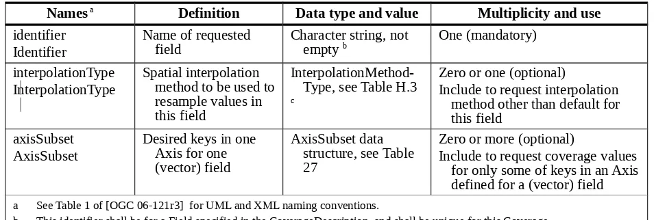
Table 2 — Parts of FieldSubset data structure
Names a Definition Data type and value Multiplicity and use
identifier Identifier
Name of requested
field Character string, not empty b One (mandatory)
interpolationType InterpolationType
Spatial interpolation method to be used to resample values in this field
InterpolationMethod-Type, see Table H.3
c
Zero or one (optional)
Include to request interpolation method other than default for this field
axisSubset AxisSubset
Desired keys in one Axis for one (vector) field
AxisSubset data structure, see Table 27
Zero or more (optional)
Include to request coverage values for only some of keys in an Axis defined for a (vector) field a See Table 1 of [OGC 06-121r3] for UML and XML naming conventions.
b This identifier shall be for a Field specified in the CoverageDescription, and shall be unique for this Coverage.
c This interpolation method type shall be one that is identified for this Field in the CoverageDescription. When this parameter is omitted, the interpolation type used shall be the default interpolation method specified for this Field, if any.
Add text and table at end of Subclause 10.2.1 (after Table 26) of the
WCS specification as follows:
As specified in footnote d of Table 24, when the GridCRS is not included in the Output data
structure, the output coverage shall use the gml:ImageCRS or wcs:GridCRS of the offered
coverage. Omitting this GridCRS thus requires output of exactly the offered coverage range
values, at (some of) the offered grid points, so no interpolation is required to be performed by
the WCS server in this case.
This implies that a client should omit the GridCRS in the Output data structure to explicitly
request no interpolation (use cases 1-5). In this case, the identified or default
InterpolationType shall be “none” for each Field included in the RangeSubset. If the
RangeSubset is not included (meaning
that all range fields shall be output)
, the default
InterpolationType shall be “none” for each Field in the coverage Range.
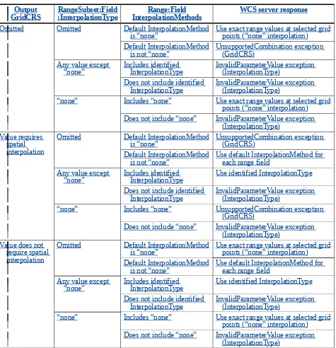
A WCS server shall respond as specified in Table 2X for the listed combinations of
Output:GridCRS, RangeSubset:Field:InterpolationType, and
Range:Field:InterpolationMethods. In particular, any value for the effective (specified or
default) InterpolationType of a RangeSubset:Field that is different from “none” shall be
detected as an error when that GridCRS is omitted. Notice that the
Table 2X — Field InterpolationType server responses
Output
GridCRS RangeSubset:Field:InterpolationType InterpolationMethodsRange:Field WCS server response
Omitted Omitted Default InterpolationMethod
is “none” Use exact range values at selected gridpoints (“none” interpolation) Default InterpolationMethod
is not “none” UnsupportedCombination exception (GridCRS) Any value except
“none” Includes identified InterpolationType InvalidParameterValue exception (InterpolationType) Does not include identified
InterpolationType InvalidParameterValue exception (InterpolationType) “none” Includes “none” Use exact range values at selected grid
points (“none” interpolation) Does not include “none” InvalidParameterValue exception
(InterpolationType) Value requires
spatial interpolation
Omitted Default InterpolationMethod
is “none” UnsupportedCombination exception (GridCRS) Default InterpolationMethod
is not “none” Use default InterpolationMethod for each range field Any value except
“none” Includes identified InterpolationType Use identified InterpolationType Does not include identified
InterpolationType InvalidParameterValue exception (InterpolationType) “none” Includes “none” UnsupportedCombination exception
(GridCRS)
Does not include “none” InvalidParameterValue exception (InterpolationType)
Value does not require spatial interpolation
Omitted Default InterpolationMethod
is “none” Use exact range values at selected gridpoints (“none” interpolation) Default InterpolationMethod
is not “none” Use default InterpolationMethod for each range field Any value except
“none” Includes identified InterpolationType Use identified InterpolationType Does not include identified
InterpolationType InvalidParameterValue exception (InterpolationType) “none” Includes “none” Use exact range values at selected grid
points (“none” interpolation) Does not include “none” InvalidParameterValue exception
(InterpolationType)
Edit Table 29 in Subclause 10.3.2 of the WCS specification as follows:
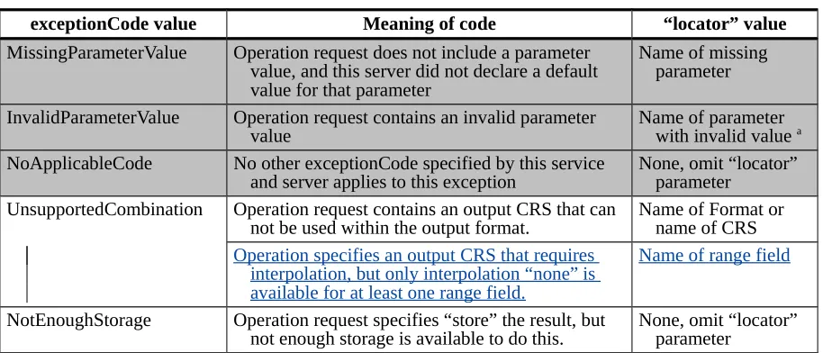
Table 3 — Exception codes for GetCoverage operation
exceptionCode value Meaning of code “locator” value
MissingParameterValue Operation request does not include a parameter value, and this server did not declare a default value for that parameter
Name of missing parameter
InvalidParameterValue Operation request contains an invalid parameter
value Name of parameter with invalid value a
NoApplicableCode No other exceptionCode specified by this service
and server applies to this exception None, omit “locator” parameter UnsupportedCombination Operation request contains an output CRS that can
not be used within the output format. Name of Format or name of CRS
Operation specifies an output CRS that requires interpolation, but only interpolation “none” is available for at least one range field.
Name of range field
NotEnoughStorage Operation request specifies “store” the result, but
not enough storage is available to do this. None, omit “locator” parameter a The Coverage parameter is not valid when the operation request identifies a Coverage that is not offered by this server. The Format parameter is not valid when the operation request identifies a Format not offered for this coverage by this server.
Edit Subclause H.3.1 of the WCS specification as follows:
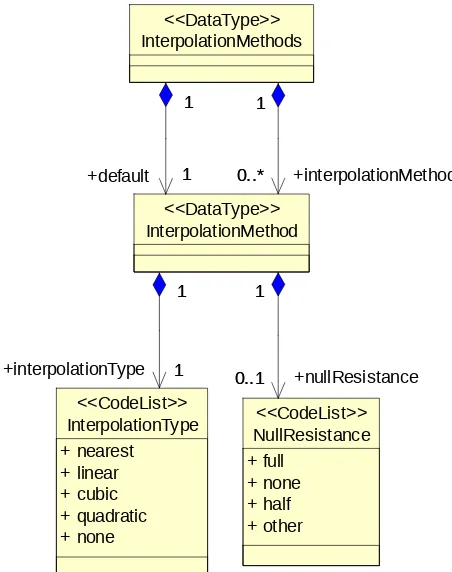
H.3.1 Interpolation methods contents
The InterpolationMethods data structure lists one or more spatial interpolation methods,
which can each be used for interpolation of a range record field in a continuous grid
+interpolationMethod
Figure H.2 — Interpolation Methods class diagram
Table H.1 — Parts of the InterpolationMethods data structure
Names a Definition Data type Multiplicity and use
default Default
Spatial interpolation method used for this range field when client doesn’t specify one b
InterpolationMethod data
structure, see Table H.6 One (mandatory)
interpolationMethod InterpolationMethod
Another spatial Interpolation method that server can apply to this range field
InterpolationMethod data
structure, see Table H.6 Zero or more (optional)Include for each other method supported c
a See Table 1 of [OGC 06-121r3] for UML and XML naming conventions.
b This default interpolation method should be the recommended or normal method for this coverage range field.
c When the default interpolation method is “none”, no other methods should be listed.
InterpolationMethods
has a mandatory
Default
parameter that identifies the spatial
interpolation method
to be
used
for when
GetCoverage requests
that
don’t specify one.
InterpolationMethods
may
also
have has
zero or more
InterpolationMethod
parameters
whose values identify other spatial interpolation methods that the server
can may
use for this
coverage range field.
However, when the default interpolation method is “none”, no other
methods should be listed. When the only listed (default) interpolation method is “none”,
clients may only retrieve subsets of this
offered
coverage in its
offered
CRS and with its
offered
resolution and grid positions. That is, the requested output grid points shall lie
exactly at some offered grid points. In this case, no interpolation is required to be performed
by a WCS server. Alternately, the “nearest” interpolation method type may be applied, to
output grid points which are always at the same locations as offered grid points.
Table H.2 — Parts of the InterpolationMethod data structure
Names a Definition Data type and value Multiplicity and use
Interpolation Met hodType
(anonymous)
Identifier of spatial interpolation
method. CodeList typeOne of the strings defined in Table H.3
One (mandatory)
nullResistance nullResistance
How server handles null values when spatially interpolating values in this field
CodeList type
One of the strings listed in Table H.4.
Zero or one (optional) Include when known
a See Table 1 of [OGC 06-121r3] for UML and XML naming conventions.
For a continuous grid coverage, the normal spatial interpolation types are listed in Table
H.3 and in the attached default InterpolationMethods.xml dictionary. Compared to ISO
19123, WCS does not distinguish linear from bilinear, quadratic from biquadratic, and
cubic from bicubic interpolation. For WCS, the linear, quadratic, and cubic interpolation
methods shall be applicable to coverages of any number of spatial dimensions. Servers
may implement and list other interpolation methods, defined in dictionaries other than the
default.
NOTE 1 The interpolation methods "lost area" and "barycentric" are not applicable to grid coverages, hence
they are not included in this version of WCS.
Table H.3 — Normal spatial interpolation types
Interpolation type
identifier Interpolationmethod Description
nearest nearest neighbour
These are defined in ISO 19123 (Schema for Coverage Geometry and Functions), Annex B.
linear
bilinear
aquadratic
biquadratic
acubic
bicubic
anone none No spatial interpolation is availablewill be done for this range field; requests must be for some exact grid point locations that are among the original domain grid point locations.
a ISO 19123 specifies two-dimensional bilinear, biquadratic, and bicubic interpolation types. When also interpolating in the elevation dimension of a 3D CRS, the 3D extensions of these interpolation types shall be used.
The Interpolation Method type “none” is special in that it prohibits execution of any
interpolation for this Field during execution of the GetCoverage operation. When the only
listed (default) interpolation method is “none”, clients may only retrieve subsets of this
offered coverage in its offered CRS and with its offered resolution and grid positions. That is,
the requested output grid points shall lie exactly at some offered grid points. This should be
requested by omitting the GridCRS in the Output part of a GetCoverage request.
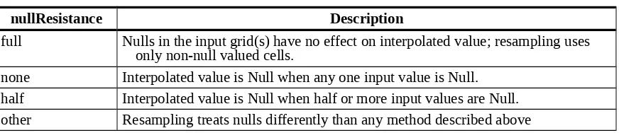
NOTE 23 These nullResistance values are sent from a server to a client, to summarize how the server treats null-valued points. These nullResistance values are NOT sent from a client to a server (to indicate how the client wants null-valued points treated).
Table H.4 — Effect of null values in spatial interpolation
nullResistance Description
full Nulls in the input grid(s) have no effect on interpolated value; resampling uses only non-null valued cells.
none Interpolated value is Null when any one input value is Null. half Interpolated value is Null when half or more input values are Null. other Resampling treats nulls differently than any method described above