Open Geospatial Consortium
Date: 2011-1-17
Reference number of this OGC® project document: OGC 08-139r3
Version:1.1
Category: OGC® Best Practice
Editor: George Demmy, Carl Reed
PDF Georegistration Encoding Best Practice Version 2.2
Copyright 2008, 2009, 2010, 2011: See Statement Next Page
Warning
This document defines an OGC Best Practice on a particular technology or approach related to an OGC standard. This document is not an OGC Standard and may not be referred to as an OGC Standard. It is subject to change without notice. However, this document is an official position of the OGC membership on this particular technology topic.
Document type: OGC® Publicly Available Best Practice Document subtype: Best Practice
OGC 08-139r3
TerraGo Technologies, Inc
ii Copyright © 2012 Open Geospatial Consortium
License Agreement
Permission is hereby granted by the Open Geospatial Consortium, ("Licensor"), free of charge and subject to the terms set forth below, to any person obtaining a copy of this Intellectual Property and any associated documentation, to deal in the Intellectual Property without restriction (except as set forth below), including without limitation the rights to implement, use, copy, modify, merge, publish, distribute, and/or sublicense copies of the Intellectual Property, and to permit persons to whom the Intellectual Property is furnished to do so, provided that all copyright notices on the intellectual property are retained intact and that each person to whom the Intellectual Property is furnished agrees to the terms of this Agreement.
If you modify the Intellectual Property, all copies of the modified Intellectual Property must include, in addition to the above copyright notice, a notice that the Intellectual Property includes modifications that have not been approved or adopted by LICENSOR.
THIS LICENSE IS A COPYRIGHT LICENSE ONLY, AND DOES NOT CONVEY ANY RIGHTS UNDER ANY PATENTS THAT MAY BE IN FORCE ANYWHERE IN THE WORLD.
THE INTELLECTUAL PROPERTY IS PROVIDED "AS IS", WITHOUT WARRANTY OF ANY KIND, EXPRESS OR IMPLIED, INCLUDING BUT NOT LIMITED TO THE WARRANTIES OF MERCHANTABILITY, FITNESS FOR A PARTICULAR PURPOSE, AND NONINFRINGEMENT OF THIRD PARTY RIGHTS. THE COPYRIGHT HOLDER OR HOLDERS INCLUDED IN THIS NOTICE DO NOT WARRANT THAT THE FUNCTIONS CONTAINED IN THE INTELLECTUAL PROPERTY WILL MEET YOUR REQUIREMENTS OR THAT THE OPERATION OF THE INTELLECTUAL PROPERTY WILL BE UNINTERRUPTED OR ERROR FREE. ANY USE OF THE INTELLECTUAL PROPERTY SHALL BE MADE ENTIRELY AT THE USER’S OWN RISK. IN NO EVENT SHALL THE COPYRIGHT HOLDER OR ANY CONTRIBUTOR OF INTELLECTUAL PROPERTY RIGHTS TO THE INTELLECTUAL PROPERTY BE LIABLE FOR ANY CLAIM, OR ANY DIRECT, SPECIAL, INDIRECT OR CONSEQUENTIAL DAMAGES, OR ANY DAMAGES WHATSOEVER RESULTING FROM ANY ALLEGED INFRINGEMENT OR ANY LOSS OF USE, DATA OR PROFITS, WHETHER IN AN ACTION OF CONTRACT, NEGLIGENCE OR UNDER ANY OTHER LEGAL THEORY, ARISING OUT OF OR IN CONNECTION WITH THE IMPLEMENTATION, USE, COMMERCIALIZATION OR PERFORMANCE OF THIS INTELLECTUAL PROPERTY.
This license is effective until terminated. You may terminate it at any time by destroying the Intellectual Property together with all copies in any form. The license will also terminate if you fail to comply with any term or condition of this Agreement. Except as provided in the following sentence, no such termination of this license shall require the termination of any third party end-user sublicense to the Intellectual Property which is in force as of the date of notice of such termination. In addition, should the Intellectual Property, or the operation of the Intellectual Property, infringe, or in LICENSOR’s sole opinion be likely to infringe, any patent, copyright, trademark or other right of a third party, you agree that LICENSOR, in its sole discretion, may terminate this license without any compensation or liability to you, your licensees or any other party. You agree upon termination of any kind to destroy or cause to be destroyed the Intellectual Property together with all copies in any form, whether held by you or by any third party.
Except as contained in this notice, the name of LICENSOR or of any other holder of a copyright in all or part of the Intellectual Property shall not be used in advertising or otherwise to promote the sale, use or other dealings in this Intellectual Property without prior written authorization of LICENSOR or such copyright holder. LICENSOR is and shall at all times be the sole entity that may authorize you or any third party to use certification marks, trademarks or other special designations to indicate compliance with any LICENSOR standards or specifications.
This Agreement is governed by the laws of the Commonwealth of Massachusetts. The application to this Agreement of the United Nations Convention on Contracts for the International Sale of Goods is hereby expressly excluded. In the event any provision of this Agreement shall be deemed unenforceable, void or invalid, such provision shall be modified so as to make it valid and enforceable, and as so modified the entire Agreement shall remain in full force and effect. No decision, action or inaction by LICENSOR shall be construed to be a waiver of any rights or remedies available to it.
OGC 08-139r3
Contents
i. Preface ... iv
ii. Submitting organizations ...v
iii. Submission contact points ...v
iv. Revision history ...v
v. Changes to the OGC® Abstract Specification ... vi
Foreword ... vii
Introduction ... viii
1 Scope...1
2 Conformance ...1
3 Normative references ...1
4 Terms and definitions ...2
5 Conventions ...3
5.1 Symbols (and abbreviated terms) ...3
5.2 UML Notation ...4
6 Overview ...4
6.1 Map Frames ...5
6.2 Projection and Display Dictionaries ...6
6.3 Datum Definitions ...9
6.4 Ellipsoid Definitions ...10
6.5 Shift Definitions ...10
7.0 Examples ...11
Annex A: Predefined Datums (Informative) ...14
Annex B: Predefined Projections (Informative) ...22
Annex C: Ellipsoids...26
Annex D...29
iv Copyright © 2007-2011 Open Geospatial Consortium
i.
Preface
This document contains the specification for the patented PDF geo-registration technique pioneered by TerraGo Technologies1. The intent of this specification is to codify existing practice and to insure that there is an official, stable best practice instance of PDF geo-registration that documents the format used in millions of existing GeoPDF® files (legacy protection). The intent is NOT to make this specification an OGC standard. Further, a Best Practice should not even be referred to as a standard. Any future work on PDF geo-registration in the OGC will be harmonized with the OGC and ISO standards baseline. An OGC Best Practice is defined as:
"A best practice is a technique or methodology that, through experience and research, has proven to reliably lead to a desired result. A commitment to using the best practices in any field is a commitment to using all the knowledge and technology at one's disposal to ensure success."2
This document is not intended to contain an explanation of the mathematical formulas that a developer might need to implement software that is capable of performing coordinate system transformations.
Comments were received during the OGC review and voting process document that PDF geo-registration 2.2 is not completely aligned with the OGC Abstract Specification Topic 2 (ISO 19101) – Spatial Referencing By Coordinates. This means that PDF
registration 2.2 is not harmonized with the OGC Standards Baseline. However, PDF geo-registration 2.2 documents an existing, widely used storage format. Changing how CRS is specified would “break” compatibility of this document and the actual storage format and metadata in the existing PDF geo-registration 2.2. Future work activities for PDF geo-registration do include harmonization with the OGC Baseline.
Finally, the OGC recognizes that the specification of the datum, ellipsoid, and CRS codes as used in this document do not conform to the EPSG database, the current de-facto normative reference for CRS metadata. As this BP documents current existing practice, harmonizing with the EPSG codes is viewed as future work.
1 Submitted to the OGC on a royalty free, non-discriminatory basis (RAND-RF)
OGC 08-139r3
ii.
Submitting organizations
The following organizations submitted this Best Practice to the Open Geospatial Consortium Inc.:
a.) TerraGo Technologies Inc.
iii.
Submission contact points
All questions regarding this submission should be directed to the editor or the submitters:
CONTACT COMPANY
George Demmy TerraGo
Victor Minor Blue Marble Geographics
iv.
Revision history
Date Release Author Paragraph modified Description
8/19/08 0.1.0 Carl Reed Not applicable First version in OGC template format
11/18/08 0.1.1 Victor Minor Not applicable Updated language to more closely match Topic 2.
1/23/09 0.1.2 Carl Reed Various Incorporate comments from Doug
Nebert, Steven Keenes and others
7/26/2010 George
Demmy and Carl Reed
Various Insert proper language as to PDF
vi Copyright © 2007-2011 Open Geospatial Consortium
v.
Changes to the OGC
®Abstract Specification
The OGC® Abstract Specification does not require changes to accommodate this OGC® standard.
vi.
Patent Information
The general technique of PDF geo-registration was patented by TerraGo technologies in the course of developing software to produce and leverage GeoPDF products. GeoPDF is a registered trademark of TerraGo Technologies and may only be applied to products created under license from TerraGo. GeoPDF products use the PDF geo-registration technique as described by this specification, but also may use other geo-registration encoding techniques, optimizations, and methods beyond the scope of this specification.
In general, creating a PDF file with a geo-registration that conforms to this specification does not create a GeoPDF product. Conformance to this specification conveys no rights for trademark usage, license to TerraGo software, or any other rights or license not specifically listed in this document.
OGC 08-139r3
Foreword
Attention is drawn to the possibility that some of the elements of this document may be the subject of patent rights (see above patent statement). Open Geospatial Consortium Inc. shall not be held responsible for identifying any or all such patent rights. However, to date, no such rights have been claimed or identified.
Recipients of this document are requested to submit, with their comments, notification of any relevant patent claims or other intellectual property rights of which they may be aware that might be infringed by any implementation of the Best Practice set forth in this
viii Copyright © 2007-2011 Open Geospatial Consortium
Introduction
The PDF geo-registration encoding specified by this document is an extension to the Adobe® Portable Document Format, as described in PDF Reference (see the Bibliography). PDF geo-registration 2.2 allows association of an arbitrary coordinate reference system to a PDF illustration. Supporting software can then perform bidirectional coordinate conversions between the coordinate reference system and the PDF coordinate system.
These illustrations are frequently maps, representations of an area on the surface of the earth. Maps are frequently constructed to be more than aesthetically pleasing. They are made to allow tasks such as retrieving coordinates or compass bearings and measuring distances or areas. However, because a map is a two-dimensional representation of a three-dimensional sphere – surface of the earth – there is inherent distortion in making a map. There is also the problem that the earth is not a perfect sphere. To be useful for such tasks the map must be created so as to minimize distortion and make what distortion cannot be avoided
predictable. There is both art and science to this. The science is composed of standardized mathematical methods, mapprojections, and idealized models of the earth, ellipsoidal coordinate system. A map projection is a mechanism for rigorously converting from an ellipsoidal coordinate system to a two-dimensional plane, or projected coordinate reference system. Every map projection’s preservations and distortions make it more useful for some tasks and less for others. For each coordinate reference system, a datum is selected that best aligns with the portion of the earth’s surface to be mapped. To learn more, see Map Projections – A Working Manual (in the Bibliography).
To fully support maps, PDF geo-registration 2.2 provides for up to three coordinate systems. These will generally be referred to as: PDF, projected and geodetic. The geodetic coordinate system is a fully defined ellipsoidal coordinate system based on the geodetic datum used to create the map. Coordinate tuples for the geodetic system are commonly expressed as geodetic longitude and latitude. The projected coordinate system is a complete projected coordinate reference system derived from the PDF geo-registration 2.2's two-dimensional geodetic coordinate reference system by the application of a fully defined map projection. The coordinate tuples for this reference system may be expressed in any linear unit, but common units are feet, meters, miles and kilometers. The PDF coordinate system is the result of scaling, translating and rotating the projected coordinate tuples to make them fit on a reasonably sized PDF page in a desired orientation. The native PDF unit is points. PDF georegistration 2.2 preserves enough information so that software can freely translate
OpenGIS® Best Practice OGC –8-139r3
GeoPDF Encoding Best Practice
1 Scope
The intended audience of this document is a developer of software for creating and consuming geo=registered PDF documents that conform to PDF geo-registration 2.2. It specifies how to create the necessary PDF objects that identify a region of the PDF page as a map and describe the map’s coordinate systems. Map creation and rendering to a PDF page are not addressed. The underlying PDF file format is not addressed. The file format is specified in PDF Reference[1] .
The reader will need knowledge of PDF objects and document structure. An understanding of cartographic projections and datums will also be helpful. Information about these can be found in Map Projections – A Working Manual[2] .
Though written with the PDF 1.7 file format in mind, this Best Practice is believed to be valid for all versions of the PDF file specification prior to PDF 1.7.
.
2 Conformance
Not required.
3 Normative references
The following normative documents contain provisions that, through reference in this text, constitute provisions of this OGC Best Practice. For dated references, subsequent amendments to, or revisions of, any of these publications do not apply. However, parties to agreements based on this part of OGC document 08-139 are encouraged to investigate the possibility of applying the most recent editions of the normative documents indicated below. For undated references, the latest edition of the normative document referred to applies.
Information about map projections:
Map Projections – A Working Manual
John P. Snyder
United States Government Printing Office, Washington, DC, 1987
2 Copyright © 2007-2011 Open Geospatial Consortium PDF Reference, sixth edition: Adobe Portable Document Format, Version 1.7
2006
Adobe Systems Incorporated
http://www.adobe.com/devnet/acrobat/pdfs/pdf_reference.pdf
IEEE Standard for Binary Floating-Point Arithmetic (IEEE 754-1985)
1985
Institute of Electrical and Electronics Engineers http://grouper.ieee.org/groups/754/
4 Terms and definitions
For the purposes of this document, the following terms and definitions apply. These terms are further extended in ISO 19111[3] and ISO 19112[4].
4.1
coordinate
one of a sequence of n numbers designating the position of a point in n-dimensional space.
Note In a coordinate reference system, the coordinate numbers are qualified by units.
4.2
coordinate reference system
coordinate system that is related to an object by a datum
4.3
coordinate set
Collection of coordinate tuples related to the same coordinate reference system.
4.4
coordinate tuple
tuple composed of a sequence of coordinates
4.5
datum
parameter or set of parameters that define the position of the origin, the scale, and the orientation of a coordinate system
4.6
coordinate conversion
OGC 08-139r3
EXAMPLE Conversion from an ellipsoidal coordinate system to projected coordinate reference system is accomplished by applying a map projection.
NOTE A coordinate conversion uses parameters which have specified values that are not determined empirically.
4.7
map projection
coordinate conversion from an ellipsoidal coordinate system to a plane
4.8
ellipsoid
surface formed by the rotation of an ellipse about a main axis
NOTE In this International Standard, ellipsoids are always oblate, meaning that the axis of rotation is always the minor axis.
4.9
ellipsoidal coordinate system geodetic coordinate system
coordinate system in which position is specified by geodetic latitude, geodetic longitude and (in the three-dimensional case) ellipsoidal height
4.10
map frame
a section of the PDF geo-registration 2.2 document that is defined by a specific neatline, and a specific coordinate reference system.
4.11
neatline
A series of PDF points defining the boundary of the map frame, in clockwise order.
5 Conventions
5.1 Symbols (and abbreviated terms)
API Application Program Interface CAD Computer Aided Design
COTS Commercial Off The Shelf
4 Copyright © 2007-2011 Open Geospatial Consortium LGI Layton Graphics Inc.
OGC Open Geospatial Consortium PDF Portable Document Format UML Unified Modeling Language
XML eXtensible Markup Language
1D One Dimensional
2D Two Dimensional
3D Three Dimensional
5.2 UML Notation Not Applicable
6 Overview
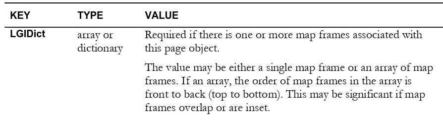
Conceptually, PDF geo-registration 2.2 specifies map frames associated with a PDF page. A minimal map frame describes a coordinate reference system that is associated with the entire document page. This association provides a collection of tuples that map the page (PDF) coordinate system to the known coordinate reference system. Optionally a neatline specifies the geometric region of the page that is associated with the foreign coordinate system. There may be multiple map frames on a given page. Map frames may overlap or be inset. The coordinate reference system of a map frame is independent of any other map frame. Map frames are associated with their parent PDF page object. Table 1 describes PDF geo-registration 2.2 additions to the standard PDF page object.
Table 1 details the entries the PDF geo-registration 2.2 Best Practice adds to a PDF page object.
TABLE 1 PDF geo-registration 2.2 entries in a page object
KEY TYPE VALUE
LGIDict array or
dictionary
Required if there is one or more map frames associated with this page object.
OGC 08-139r3
6.1 Map Frames
The map frame describes the relationship between a coordinate reference system and an area on the PDF page. Three types of coordinate reference systems are supported: geodetic, projected and unregistered Cartesian (Engineering). In each case, the coordinate reference system is transformed into the PDF coordinate system with a coordinate
transformation matrix as discussed in section 4.2.3 of PDF Reference[1]. The map frame contains PDF dictionary entries that describe the coordinate transformation matrix, all parameters required for a map projection (if used), the reference ellipsoid and geodetic datum. More than one map frame may be present on a single PDF page.
For simplicity, the map frame follows certain conventions. All angular values are in degrees. When angular coordinates are needed in a context where Cartesian x and y coordinate values would normally be expected, use the longitudinal values as x values and the latitudinal values as y values.
Due to limitations in Acrobat® internal numeric representations, PDF geo-registration 2.2
allows an alternate representation of numbers. Any number within a map frame may be expressed as a PDF string. The value of the string is a printed representation of the number. MAP2PDF® performs coordinate transformations using IEEE double-precision
floating-point numbers as described in IEEE Standard for Binary Floating-Point Arithmetic (see the Bibliography). Acrobat® 6, 7 and 8 use IEEE single-precision floating-point numbers. Earlier
versions used a 32-bit fixed-point numbers. Use of string representation for projection parameter values and transformation matrix members is highly recommended. Numbers not expressed as a PDF string will be subject to the limitations of Acrobat numeric
representations.
Table 2 details the content of a map frame.
TABLE 2 Entries in a map frame
KEY TYPE VALUE
Type name (Required) The type of object that this dictionary describes;
must be LGIDict for a map frame.
6 Copyright © 2007-2011 Open Geospatial Consortium
CTM array (Required if registration points are not present) The Coordinate
Transformation Matrix mapping from the PDF coordinate system to the projected or geodetic coordinate system. A transformation matrix takes precedence over registration points when both are present.
This array follows the same convention as the array parameter to the PDF coordinate transformation operator, cm, with the exception of allowing string representations.
Registration array (Required if a transformation matrix is not present) A series of
registration point pairs.
A transformation matrix takes precedence over registration points when both are present.
Each point pair is given as an array of four values: a PDF x
value, a PDF y value, a map x value, and a map y value.
Projection dictionary (Required if a geodetic or projected coordinate system) A projection dictionary (see “Projection and Display Dictionaries,” below).
Display dictionary (Optional) A display dictionary (see “Projection and Display
Dictionaries,” below).
Neatline array (Required if multiple map frames are present; otherwise optional) A series of PDF points defining the boundary of the map frame, in clockwise order.
The values in this array are interpreted as x and y values specifying PDF page points. The minimum number of points is two, which will be interpreted as a diagonal describing a rectangular bounding box.
Note: If Projection is not present, the value is assumed to be NONE (see Appendix B).
6.2 Projection and Display Dictionaries
The projection dictionary describes the algorithm and parameters required to define the coordinate reference system used in each map frame of the PDF geo-registration 2.2 document. Each map projection algorithm has a series of required parameters (see Appendix B). The parameter values vary with the geographic center and possibly the range of the data to be projected. The geodetic datum and map projection parameters are preserved in the projection dictionary. Supported geodetic datums and their associated PDF geo-registration 2.2 codes are listed in Appendix A. Supported map projections and associated PDF geo-registration 2.2 codes are listed in Appendix B. Appendix B includes the parameters required by and notes pertinent to each projection.
OGC 08-139r3
Note: The PDF geo-registration 2.2 notion of projection is more general than the typical cartographic usage. It includes some grid systems, such as Universal Transverse
Mercator, which combine a projection algorithm with a system of standardized projection parameters.
Projection parameters are of a number of types. Most are either linear or angular. Linear values should always be expressed in meters, regardless of the native linear unit of the projection coordinate reference system. Angular values should always be given in degrees. Most angular values are either used in to define specific geodetic longitude or latitude values. Longitude values are relative to the Greenwich prime meridian, positive values being to the east and negative to the west. The supported range for longitudes is -180° to -180°. Latitude values are relative to the equator, positive values being to the north and negative values to the south. The supported range is -90° to 90°. Latitude and
longitude are typically represented in PDF geo-registration 2.2 as decimal degrees. However, PDF geo-registration 2.2 files have been created using degrees decimal-minutes and degrees, decimal-minutes, and decimal-seconds. Consuming applications should be prepared to read such files.
A display dictionary is used to specify the coordinate system a consuming application should use to display non-PDF coordinate reference values.
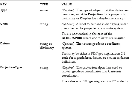
Table 2 details the contents of a projection or display dictionary.
TABLE 2 Entries in a projection or display dictionary
KEY TYPE VALUE
Type name (Required) The type of object that this dictionary
describes; must be Projection for a projection dictionary or Display for a display dictionary.
Units string (Optional) A label to be used in displaying linear
measures in the projected coordinate system. This is nonsensical in the case of the
GEOGRAPHIC where coordinates are angular.
Datum string or
dictionary
(Optional) The source geodetic coordinate system.
This may be either a PDF geo-registration 2.2 code for a predefined datum, or a custom datum definition.
ProjectionType string (Required) The projection algorithm used to
project geodetic coordinates into Cartesian coordinates.
8 Copyright © 2007-2011 Open Geospatial Consortium
a predefined projection.
CentralMeridian number (Optional) A projection parameter.
This is a longitude value.
FalseEasting number (Optional) A projection parameter. This is a linear value.
FalseNorthing number (Optional) A projection parameter.
This is a linear value.
Height number (Optional) A projection parameter (see Appendix B).
This is a linear value.
Hemisphere string (Optional) A projection parameter.
Supported values are N or S, indicating the northern or southern hemisphere.
LatitudeOne number (Optional) A projection parameter.
This is a latitude value.
LatitudeTwo number (Optional) A projection parameter. This is a latitude value.
LatitudeOfTrueScale number (Optional) A projection parameter.
This is a latitude value.
LongitudeOne number (Optional) A projection parameter. This is a longitude value.
LongitudeTwo number (Optional) A projection parameter.
This is a longitude value.
LongitudeDownFromPole number (Optional) A projection parameter. This is a longitude value.
Orientation number (Optional) A projection parameter.
This is an angular offset.
OriginHeight number (Optional) A projection parameter.
This is a linear value.
OriginLatitude number (Optional) A projection parameter. This is a longitude value.
OGC 08-139r3
This is a longitude value.
ScaleFactor number (Optional) A projection parameter.
This is a scalar value.
StandardParallel number (Optional) A projection parameter. This is a latitude value.
StandardParallelOne number (Optional) A projection parameter.
This is a latitude value.
StandardParallelTwo number (Optional) A projection parameter. This is a latitude value.
Zone number (Optional) A projection parameter.
This is an integral value. The supported values are dependent on ProjectionType.
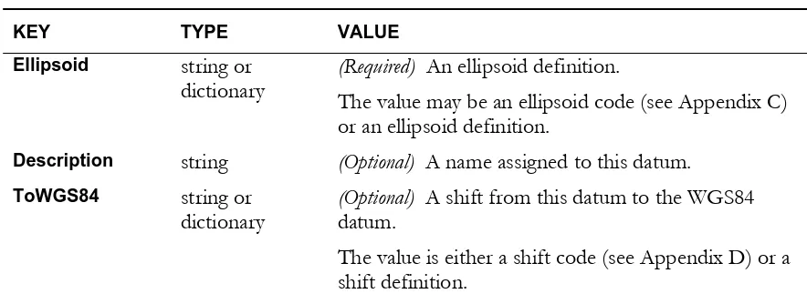
6.3 Datum Definitions
In addition to predefined geodetic datum codes, PDF geo-registration 2.2 supports custom geodetic datum definitions. A geodetic datum is comprised of an ellipsoid, a known origin point, and a prime meridian. In the case of PDF geo-registration 2.2 documents, a
Greenwich prime meridian is assumed. Additionally, the dictionary description for a custom geodetic datum can contain a shift, a mathematical operation that converts (at least
approximately) the geodetic datum’s coordinates to the widely-used World Geodetic System 1984 geodetic datum (WGS84).
Table 3 details the contents of a custom datum definition.
TABLE 3 Entries in a custom geodetic datum definition
KEY TYPE VALUE
Ellipsoid string or
dictionary
(Required) An ellipsoid definition.
The value may be an ellipsoid code (see Appendix C) or an ellipsoid definition.
Description string (Optional) A name assigned to this datum.
ToWGS84 string or
dictionary
(Optional) A shift from this datum to the WGS84 datum.
10 Copyright © 2007-2011 Open Geospatial Consortium 6.4 Ellipsoid Definitions
An ellipsoid is a surface formed by the rotation of an ellipse about a main axis. Along with a defined center point and prime meridian, it can be used as a model that approximates the surface of the earth. It is described by a semi-major axis and either a semi-minor axis or an inverse flattening. Table 4 details the contents of an ellipsoid definition.
TABLE 4 Entries in a custom ellipsoid definition
KEY TYPE VALUE
SemiMajorAxis number (Required) The length of the ellipsoid semi-major axis,
i.e. the radius of the earth at its equator.
InvFlattening number (Required if semi-minoraxis is not specified) 1/f, where f = (a-b)/a, and a is the semi-major axis and b is the semi-minor axis.
SemiMinorAxis number (Required if inverse flattening is not specified) The length of the ellipsoid semi-minor axis, i.e. half the distance from the north pole to the south pole.
Description string (Optional) A name assigned to this ellipsoid.
6.5 Shift Definitions
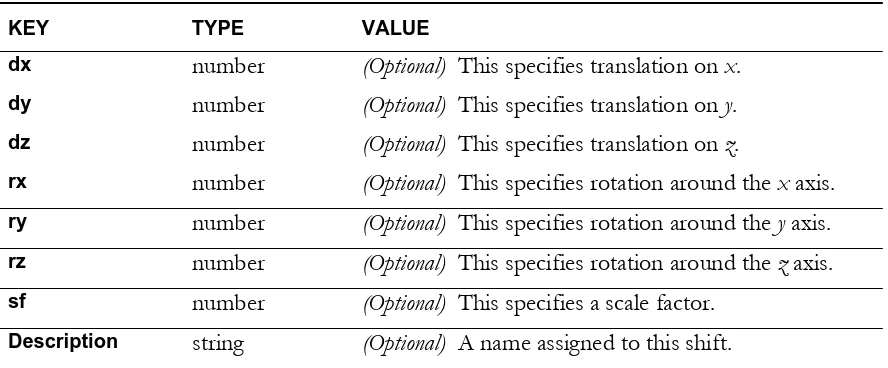
A shift definition specifies how to convert a map frames geodetic datum’s coordinate values to equivalent ellipsoidal coordinates on a WGS84 geodetic datum. Table 5 details the content of a shift definition.
TABLE 5 Entries in a shift definition
KEY TYPE VALUE
dx number (Optional) This specifies translation on x.
dy number (Optional) This specifies translation on y.
dz number (Optional) This specifies translation on z.
rx number (Optional) This specifies rotation around the x axis. ry number (Optional) This specifies rotation around the y axis. rz number (Optional) This specifies rotation around the z axis. sf number (Optional) This specifies a scale factor.
OGC 08-139r3
7.0 Examples
Example 1: The following example illustrates a single map frame associated with a PDF page. The map frame has a projected coordinate reference system that uses an Albers Equal Area Conic map projection.
105 0 obj <<
/Type /Page
/LGIDict 104 0 R
% remainder of the PDF Page dictionary not reproduced in this example
(3524.5004673001) (0.0000000000)
(0.0000000000) (3524.5004673001)
/StandardParallelOne (20.00000)
/StandardParallelTwo (60.00000)
/FalseNorthing (0.00000)
/Datum (NAR)
/OriginLatitude (40.00000)
/CentralMeridian (-96.00000) /FalseEasting (0.00000)
>>
/Display <<
/Type /Projection
/ProjectionType (AC)
/StandardParallelOne (20.00000)
/StandardParallelTwo (60.00000)
/FalseNorthing (0.00000)
/OriginLatitude (40.00000)
/CentralMeridian (-96.00000)
/Units (M)
/FalseEasting (0.00000)
/Datum (NAR)
>>
/Description (Southwestern United States)
/Registration % two points, describing a rectangle
[[
(53.5103998492) (124.5528002880) % PDF
(-2304773.0647479948) (-1099101.2766873206) % map
]
[
(725.0183996828) (560.4984001800) % PDF
(61957.1944612906) (437389.1938494640) % map
]]
/Neatline % must be in PDF coordinate system [
12 Copyright © 2007-2011 Open Geospatial Consortium
(53.5103998492) (560.4984001800)
(725.0183996828) (560.4984001800)
(725.0183996828)(124.5528002880) ]
>> endobj
Example 2: The next example illustrates two map frames associated with a single PDF page. The first map frame has a geodetic coordinate reference system and the second an arbitrary Cartesian (Engineering) coordinate reference system.
187 0 obj <<
/Type /Page
/LGIDict [ 188 0 R 189 0 R ]
% remainder of the PDF Page dictionary not reproduced in this example
(0.5367729901) (-0.3099060303)
(0.3099060303) (0.5367729901)
(-1134.6947857129) (346.9822048049)
]
/Description (Map 1) /Display
<<
/Type /Projection
/ProjectionType (GEODETIC)
/Datum (WE) /Neatline
>>
/Neatline [
(1513.0683996836) (64.1739002400)
(1513.0683996836) (834.8877001440)
(2213.0683995964) (834.8877001440)
(2213.0683995964) (64.1739002400)
]
/Projection <<
/Type /Projection
/ProjectionType (GEOGRAPHIC)
/Datum (WE)
>> >>
OGC 08-139r3
189 0 obj
<<
/Type /LGIDict
/Version (2.1)
/CTM [
(0.0900555640) (-0.0519936041)
(0.0519936041) (0.0900555640)
(-62.2728952159) (-0.9403414838)
]
/Description (Map 2) /Neatline
[
(351.4285240577) (64.1739002400)
(351.4285240577) (834.8877001440)
(1051.4284747903) (834.8877001440)
(1051.4284747903) (64.1739002400)
]
/Projection
<<
/Type /Projection
/ProjectionType (NONE)
>> >>
14 Copyright © 2007-2011 Open Geospatial Consortium
Annex A: Predefined Datums
(Informative)
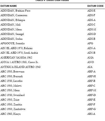
Table 6 below lists the predefined datums supported in PDF geo-registration 2.2 at the time of publication of this Best Practice. Datum names are those used by the U.S. National Geospatial-Intelligence Agency’s GEOTRANS software (see the Bibliography).
TABLE 6 Datum Code Values
DATUM NAME DATUM CODE
ADINDAN, Burkina Faso ADI-E
ADINDAN, Cameroon ADI-F
ADINDAN, Ethiopia ADI-A
ADINDAN, Mali ADI-C
ADINDAN, Mean ADI-M
ADINDAN, Senegal ADI-D
ADINDAN, Sudan ADI-B
AFGOOYE, Somalia AFG
AIN EL ABD 1970, Bahrain AIN-A AIN EL ABD 1970, Saudi Arabia AIN-B
AMERICAN SAMOA 1962 AMA
ANNA 1 ASTRO 1965, Cocos Is. ANO ANTIGUA ISLAND ASTRO 1943 AIA
ARC 1950, Botswana ARF-A
ARC 1950, Burundi ARF-H
ARC 1950, Lesotho ARF-B
ARC 1950, Malawi ARF-C
ARC 1950, Mean ARF-M
ARC 1950, Swaziland ARF-D
ARC 1950, Zaire ARF-E
ARC 1950, Zambia ARF-F
ARC 1950, Zimbabwe ARF-G
OGC 08-139r3
ARC 1960, Kenya & Tanzania ARS-M
ARC 1960, Tanzania ARS-B
ASCENSION ISLAND 1958 ASC
ASTRO BEACON E 1945, Iwo Jima ATF ASTRO DOS 71/4, St. Helena Is. SHB ASTRO STATION 1952, Marcus Is. ASQ ASTRO TERN ISLAND (FRIG) 1961 TRN AUSTRALIAN GEODETIC 1966 AUA AUSTRALIAN GEODETIC 1984 AUG AYABELLE LIGHTHOUSE, Djibouti PHA BELLEVUE (IGN), Efate Is. IBE BERMUDA 1957, Bermuda Islands BER
BISSAU, Guinea-Bissau BID
BOGOTA OBSERVATORY, Columbia BOO BUKIT RIMPAH, Banka & Belitung BUR CAMP AREA ASTRO, Camp McMurdo CAZ CAMPO INCHAUSPE 1969, Arg. CAI CANTON ASTRO 1966, Phoenix Is. CAO CAPE CANAVERAL, Fla & Bahamas CAC
CAPE, South Africa CAP
CARTHAGE, Tunisia CGE
CHATHAM ISLAND ASTRO 1971, NZ CHI
CHUA ASTRO, Paraguay CHU
CORREGO ALEGRE, Brazil COA
DABOLA, Guinea DAL
DECEPTION ISLAND DID
DJAKARTA, INDONESIA BAT
DOS 1968, Gizo Island GIZ
EASTER ISLAND 1967 EAS
ESTONIA, 1937 EST
EUROPEAN 1950, Cyprus EUR-E
EUROPEAN 1950, Egypt EUR-F
16 Copyright © 2007-2011 Open Geospatial Consortium
EUROPEAN 1950, England, Ireland EUR-K
EUROPEAN 1950, Greece EUR-B
EUROPEAN 1950, Iran EUR-H
EUROPEAN 1950, Iraq, Israel EUR-S
EUROPEAN 1950, Malta EUR-L
EUROPEAN 1950, Mean (3 Param) EUR-M EUROPEAN 1950, Mean (7 Param) EUR-7 EUROPEAN 1950, Norway & Finland EUR-C EUROPEAN 1950, Portugal & Spain EUR-D EUROPEAN 1950, Sardinia(Italy) EUR-I EUROPEAN 1950, Sicily(Italy) EUR-J EUROPEAN 1950, Tunisia EUR-T EUROPEAN 1950, Western Europe EUR-A
EUROPEAN 1979 EUS
FORT THOMAS 1955, Leeward Is. FOT GAN 1970, Rep. of Maldives GAA Geocentric Datum of Australia GDS
GEODETIC DATUM 1949, NZ GEO
GRACIOSA BASE SW 1948, Azores GRA
GUAM 1963 GUA
GUNUNG SEGARA, Indonesia GSE GUX 1 ASTRO, Guadalcanal Is. DOB HERAT NORTH, Afghanistan HEN HERMANNSKOGEL, old Yugoslavia HER
HJORSEY 1955, Iceland HJO
HONG KONG 1963 HKD
HR1901G Croatia (Helmert) HRG-7
HU-TZU-SHAN, Taiwan HTN
INDIAN 1954, Thailand INF-A
INDIAN 1960, Con Son Island ING-B INDIAN 1960, Vietnam 16N ING-A
INDIAN 1975, Thailand INH-A
OGC 08-139r3
INDIAN, Bangladesh IND-B
INDIAN, India & Nepal IND-I
INDIAN, Pakistan IND-P
INDONESIAN 1974 IDN
IRELAND 1965 IRL
ISTS 061 ASTRO 1968, S Georgia ISG ISTS 073 ASTRO 1969, Diego Garc IST
JOHNSTON ISLAND 1961 JOH
KANDAWALA, Sri Lanka KAN
KERGUELEN ISLAND 1949 KEG
KERTAU 1948, W Malaysia & Sing. KEA KOREAN GEO DATUM 1995, S Korea KGS KUSAIE ASTRO 1951, Caroline Is. KUS L.C. 5 ASTRO 1961, Cayman Brac LCF
LEIGON, Ghana LEH
LIBERIA 1964 LIB
LUZON, Mindanao Island LUZ-B
LUZON, Phillipines LUZ-A
MAHE 1971, Mahe Is. MIK
MASSAWA, Ethiopia MAS
MERCHICH, Morocco MER
MIDWAY ASTRO 1961, Midway Is. MID
MINNA, Cameroon MIN-A
MINNA, Nigeria MIN-B
MONTSERRAT ISLAND ASTRO 1958 ASM
M'PORALOKO, Gabon MPO
NAHRWAN, Masirah Island (Oman) NAH-A
NAHRWAN, Saudi Arabia NAH-C
18 Copyright © 2007-2011 Open Geospatial Consortium
NORTH AMERICAN 1927, Aleutian W NAS-W NORTH AMERICAN 1927, Bahamas NAS-Q NORTH AMERICAN 1927, C. America NAS-N NORTH AMERICAN 1927, Canada NAS-E NORTH AMERICAN 1927, Canal Zone NAS-O NORTH AMERICAN 1927, Caribbean NAS-P NORTH AMERICAN 1927, CONUS NAS-C NORTH AMERICAN 1927, Cuba NAS-T NORTH AMERICAN 1927, E. Canada NAS-G NORTH AMERICAN 1927, Eastern US NAS-A NORTH AMERICAN 1927, Greenland NAS-U NORTH AMERICAN 1927, Man/Ont NAS-H NORTH AMERICAN 1927, Mexico NAS-L NORTH AMERICAN 1927, Michigan NAS-M NORTH AMERICAN 1927, NW Terr. NAS-I NORTH AMERICAN 1927, San Salv. NAS-R NORTH AMERICAN 1927, Western US NAS-B NORTH AMERICAN 1927, Yukon NAS-J NORTH AMERICAN 1983, Alaska NAR-A NORTH AMERICAN 1983, Aleutian NAR-E NORTH AMERICAN 1983, Canada NAR-B NORTH AMERICAN 1983, CONUS NAR-C NORTH AMERICAN 1983, Hawaii NAR-H NORTH AMERICAN 1983, Mexico NAR-D NORTH SAHARA 1959, Algeria NSD OBSERVATORIO MET. 1939, Flores FLO
OLD EGYPTIAN 1907 OEG
OGC 08-139r3
OLD HAWAIIAN (IN), Kauai OHI-B OLD HAWAIIAN (IN), Maui OHI-C OLD HAWAIIAN (IN), Mean OHI-M OLD HAWAIIAN (IN), Oahu OHI-D
OMAN FAH ORDNANCE GB 1936, Eng., Wales OGB-B
ORDNANCE GB 1936, England OGB-A ORDNANCE GB 1936, Mean (3 Para) OGB-M ORDNANCE GB 1936, Mean (7 Para) OGB-7 ORDNANCE GB 1936, Scotland OGB-C ORDNANCE GB 1936, Wales OGB-D PICO DE LAS NIEVES, Canary Is. PLN
PITCAIRN ASTRO 1967 PIT
POINT 58, Burkina Faso & Niger PTB
POINT NOIRE 1948, Congo PTN
PORTO SANTO 1936, Madeira Is. POS PROV. S AMERICAN 1956, Bolivia PRP-A PROV. S AMERICAN 1956, Colombia PRP-D PROV. S AMERICAN 1956, Ecuador PRP-E PROV. S AMERICAN 1956, Guyana PRP-F PROV. S AMERICAN 1956, Mean PRP-M PROV. S AMERICAN 1956, N Chile PRP-B PROV. S AMERICAN 1956, Peru PRP-G PROV. S AMERICAN 1956, S Chile PRP-C PROV. S AMERICAN 1956, Venez PRP-H PROVISIONAL SOUTH CHILEAN 1963 HIT PUERTO RICO & Virgin Is. PUR
PULKOVO 1942, Russia PUK
QATAR NATIONAL QAT
QORNOQ, South Greenland QUO
REUNION, Mascarene Is. REU
ROME 1940, Sardinia MOD
20 Copyright © 2007-2011 Open Geospatial Consortium
S-42 (PK42) Former Czechoslov. SPK-C S-42 (PULKOVO 1942), Albania SPK-F S-42 (PULKOVO 1942), Hungary SPK-A S-42 (PULKOVO 1942), Latvia SPK-D S-42 (PULKOVO 1942), Poland SPK-B S-42 (PULKOVO 1942), Romania SPK-G
SANTO (DOS) 1965 SAE
SAO BRAZ, Santa Maria Is. SAO SAPPER HILL 1943, E Falkland Is SAP
SCHWARZECK, Namibia SCK
SELVAGEM GRANDE 1938, Salvage Is SGM
SIERRA LEONE 1960 SRL
SIRGAS, South America SIR
S-JTSK, Czech Republic CCD
SOUTH AMERICAN 1969, Argentina SAN-A SOUTH AMERICAN 1969, Baltra SAN-J SOUTH AMERICAN 1969, Bolivia SAN-B SOUTH AMERICAN 1969, Brazil SAN-C SOUTH AMERICAN 1969, Chile SAN-D SOUTH AMERICAN 1969, Colombia SAN-E SOUTH AMERICAN 1969, Ecuador SAN-F SOUTH AMERICAN 1969, Guyana SAN-G SOUTH AMERICAN 1969, Mean SAN-M SOUTH AMERICAN 1969, Paraguay SAN-H SOUTH AMERICAN 1969, Peru SAN-I SOUTH AMERICAN 1969, Trinidad SAN-K SOUTH AMERICAN 1969, Venezuela SAN-L
SOUTH ASIA, Singapore SOA
TANANARIVE OBSERVATORY 1925 TAN TIMBALAI 1948, Brunei & E Malay TIL
TOKYO, Japan TOY-A
TOKYO, Mean TOY-M
OGC 08-139r3
TOKYO, South Korea TOY-B
TOKYO, South Korea TOY-B1
TRISTAN ASTRO 1968 TDC
VITI LEVU 1916, Viti Levu Is. MVS
VOIROL 1874, Algeria VOI
VOIROL 1960, Algeria VOR
WAKE ISLAND ASTRO 1952 WAK
WAKE-ENIWETOK 1960 ENW
YACARE, Uruguay YAC
22 Copyright © 2007-2011 Open Geospatial Consortium
Annex B: Predefined Projections
(Informative)
This Annex lists the predefined coordinate reference systems supported by PDF georegistration 2.2 at the time of publication of this Best Practice. Also included are the names of required projection parameters and pertinent notes. The table shows three coordinate reference system cases, an arbitrary Cartesian (Engineering) system (NONE), a geodetic (ellipsoidal) system (GEODETIC), and various projected systems.
Projection, Codes and Parameters
PROJECTION
Geodetic GEODETIC Direct geodetic to Cartesian mapping. For use only in projection dictionaries.
Geographic GEOGRAPHIC For use only in display dictionaries. Signifies display of geodetic coordinates. Local Cartesian LOCAL
CARTESIAN
OGC 08-139r3
Zone is the Federal Information Processing Standards (FIPS) code. State Plane 1983 SPCS Zone The value expected for
Zone is the FIPS code.
Bonne BF OriginLatitude CentralMeridian
FalseEasting FalseNorthing
Cassini CS OriginLatitude CentralMeridian Eckert IV* EF CentralMeridian
FalseEasting FalseNorthing Eckert VI* ED CentralMeridian
FalseEasting Gnomonic* GN OriginLatitude
CentralMeridian FalseEasting FalseNorthing
24 Copyright © 2007-2011 Open Geospatial Consortium
Mercator MC OriginLatitude CentralMeridian
Mollweide* MP CentralMeridian FalseEasting Orthographic* OD OriginLatitude
CentralMeridian
Polyconic PH OriginLatitude CentralMeridian
OGC 08-139r3
Sinusoidal SA CentralMeridian FalseEasting
FalseNorthing Stereographic SD OriginLatitude
CentralMeridian FalseEasting FalseNorthing Transverse
Mercator
TC OriginLatitude CentralMeridian
ScaleFactor FalseEasting FalseNorthing Transverse
Cylindrical Equal Area
TX OriginLatitude CentralMeridian
ScaleFactor FalseEasting FalseNorthing Van der Grinten VA CentralMeridian
FalseEasting FalseNorthing
26 Copyright © 2007-2011 Open Geospatial Consortium
Annex C: Ellipsoids
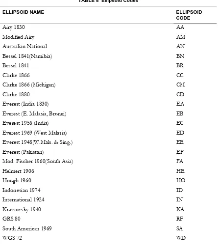
Table 8 below lists the predefined ellipsoids supported by PDF geo-registration 2.2 at the time of publication of this Best Practice. Ellipsoid names are those used by the U.S. National Geospatial-Intelligence Agency’s GEOTRANS software (see the Bibliography).
TABLE 8 Ellipsoid Codes
ELLIPSOID NAME ELLIPSOID
CODE
OGC 08-139r3
OGC 08-139r3
Annex D
30 Copyright © 2007-2011 Open Geospatial Consortium
Bibliography
[1] PDFREFERENCE, SIXTH EDITION:ADOBE PORTABLE DOCUMENT FORMAT,VERSION
1.7,2006,ADOBE SYSTEMS INCORPORATED,
(HTTP://WWW.ADOBE.COM/DEVNET/ACROBAT/PDFS/PDF_REFERENCE.PDF)
[2] SNYDER,JOHN P. Map Projections: A Working Manual, USGS Professional Paper
1395, 1987
[3] ISO 19111, Geographic Information - Spatial referencing by coordinates
[4] ISO 19112, Geographic information — Spatial referencing by geographic
identifiers
[3] ISO 31 (all parts), Quantities and units.
[4] IEC 60027 (all parts), Letter symbols to be used in electrical technology. [5] ISO 1000, SI units and recommendations for the use of their multiples and of
certain other units.
[6] Bufkin, Michael P., George G. Demmy, and D. Alan Stewart. 2009. Methods and