SRTM DEM-AIDED DEM EXTRACTION METHOD FOR ISLAND AND REEF
X. W. Chen a,b *, C. Zhao a, H. T. Guo a, Y. Z. Lin a, D. H. Yu a
a Zhengzhou Institute of Surveying and Mapping, Zhengzhou, China - [email protected] b Faculty of Geosciences and Environmental Engineering, Southwest Jiaotong University, Chengdu, China
Commission II, WG II/2
KEY WORDS: DEM Extraction, Island and Reef Image, SRTM DEM, Rational Function Model, Least Square Matching
ABSTRACT:
An SRTM DEM-aided DEM extraction method for island and reef is proposed to solve the problem of island and reef DEM extraction based on satellite imagery. The SRTM DEM is fully integrated into this method, namely, it is used to provide initial elevation for DEM and also to mark the sea area points in order to avoid the adverse effect of sea area image on DEM extraction. When determining elevations of grid points, only the valid land area points (VLPs) are taken into account. On the basis of initial elevation, the image coordinates of VLPs in multi-view images are determined and precise coordinates of conjugate points are obtained based on least square matching, then ground coordinates of VLPs are acquired by forward intersection. Finally, the elevations of VLPs are determined based on these object space points through data interpolation, and the sea area points are set as a uniform value. Experimental results show that the method can effectively solve the problem of island and reef DEM extraction. It can effectively extract DEM from island and reef satellite images regardless of the land area proportion, and island and reef can be completely extracted. Accuracy of the extracted DEM would improve with the increase of DEM resolution; when the resolution is relative high, the accuracy is consistent with SRTM DEM. The computational efficiency depends on the land area proportion and DEM resolution.
* Corresponding author
1. INTRODUCTION
As outpost of national defence and important base of marine resources development, island and reef have attracted more and more attention. Their precise basic geographic information acquired through surveying and mapping, such as terrain and geomorphology, plays a pivotal role in defence construction, island and reef development and utilization as well as marine economic development.
Due to the fact that island and reef are widely distributed and far from mainland, the traditional full field mapping approach has the disadvantages of great risk, high cost and low efficiency. The means of aerospace remote sensing could overcome the limitation of natural conditions, and can rapidly and efficiently obtain geographic information of island and reef. In addition, for the surveying and mapping of island and reef which distribute in open sea, disputed or illegally occupied by other countries, space-borne sensors can carry on continuous observation, and space remote sensing is the most ideal means of surveying and mapping.
DEM is one of the most important mapping products. Extracting DEM through photogrammetry always need image matching and obtain precise conjugate points, and then determining the ground coordinates in object space. However, large or small sea areas in island and reef images, which have the characteristics of repeated textures, are not conducive to matching. It may cause a large number of gross errors in the extracted DEM, and even lead to the failure of DEM extraction. At present, DEM extraction is mostly based on aerial images and their high-precision exterior orientation elements, but DEM extraction for island and reef regions based on satellite images is rarely reported.
Mapping satellite-1, also known as TianHui-1 (TH-1), is the first generation of Chinese high-resolution transmission stereo mapping satellite. Its engineering objective is to achieve the geolocation accuracy required for 1:50 000 topographic mapping without ground control points (GCPs) (Wang et al. 2013). The images used for stereo mapping are obtained by line-matrix CCD camera which consists of four matrix CCD cameras point toward the nadir and a three-line array CCD (TLC) camera pointing forward, nadir and backward respectively. The ground sampling distance (GSD) of TLC image is 5m.
Therefore, this paper focuses on island and reef DEM extraction based on TH-1 imagery and proposes an SRTM DEM-aided DEM extraction method. The widely used and with high-precision SRTM DEM, which could provide initial elevation for the target DEM and be used to eliminate the sea area to effectively avoid the adverse effect of sea area image on DEM extraction, is selected as auxiliary data. The organization of this paper is as follows. Section 2 provides information about SRTM DEM. In Section 3, the proposed DEM extraction method is introduced. Experimental results and analysis are presented in Section 4. The general conclusions are given in Section 5.
2. SRTM DEM
SRTM DEM V4.1 (http://srtm.csi.cgiar.org), the latest version of SRTM DEM, was produced by International Centre for Tropical Agriculture (CIAT) based on interpolation method (Reuter et al. 2007), which used SRTM 30 and other auxiliary DEMs to fill data voids in SRTM V3. Its absolute vertical and planimetric accuracy are 16 m and 20 m, respectively, at the 90% confidence level. The dataset features a resolution of 3 ISPRS Annals of the Photogrammetry, Remote Sensing and Spatial Information Sciences, Volume IV-2/W4, 2017
arc-seconds (90 m near the equator) and spans 60° N to 56° S. Its horizontal coordinate datum and height datum arethe World Geodetic System 84 (WGS84) ellipsoid and the Earth Gravitational Model 96 (EGM96) geoid model, respectively. It has attracted extensive attentions from researchers since distribution, and the accuracy evaluation results from both official and researchers have shown that its accuracy is higher than ASTER GDEM by far (Rodríguez et al. 2006; Satge et al. 2015). Therefore, SRTM DEM V4.1 is chosen as reference data in this paper.
SRTM DEM is of high elevation accuracy and sea area elevation is set as a unified and invalid value. Therefore, on one hand, high-precision initial elevation for the target DEM could be obtained. On the other hand, we can effectively distinguish between sea area grid points and land area grid points of the target DEM, and only need to consider land area grid points elevation determination. Thus, the negative impact of the texture repetitive sea area image could be overcome effectively. The elevation of SRTM DEM need to convert to geodetic height before application, and the elevation mentioned later is geodetic height.
3. METHODOLOGY
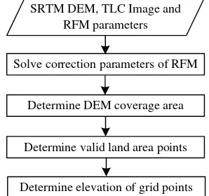
This method introduces SRTM DEM into the DEM extraction process, and makes full use of its high-precision. The principle of the method is as follows. Firstly, system errors in rational function model (RFM) parameters are compensated. Then, DEM coverage area is determined according to the RFM parameters, sea area points (SPs) and extraterritorial points are removed when determining the initial elevation of grid points based on SRTM DEM through data interpolation. Only land area points within the image coverage, namely valid land area points (VLPs), are used in the subsequent process. Next, VLPs are projected to corresponding TLC images to acquire the imagery is the main data source of this paper, we represent the extracted DEM by TH-DEM.
Figure 1. Flowchart of the proposed method
3.1 RFM Parameters Bias Correction
At present, the star sensors of TH-1 is of relative low accuracy, thus the geolocation accuracy of forward intersection without block adjustment or GCPs, especially the vertical accuracy,
cannot meet its engineering objective. Under such a condition, errors in image orientation parameters should be corrected before DEM extraction.
RFM, well known and widely used in the distribution and processing of satellite imagery, has been proved to be very simple, fast, and stable. Therefore, this paper discusses the geolocation accuracy and error compensation model based on RFM, and its general form is given in
power of each component or the sum of the power is not more than 3 (Fraser
et al
.
2006)There is no real physical meaning for RFM parameters, thus the bias correction is usually in the way of offset compensation, namely, a polynomial model of image coordinates is used to represent the system errors of RFM (Grodecki and Dial, 2003). And the most common and stable model is the affine x, y= the observations of image coordinates
e0, e1, e2, f0, f1, f2 = the affine transformation parameters
Due to the low geolocation accuracy of TH-1 imagery, bundle block adjustment (Wang et al. 2013) and method assisted by existing orthoimage, local DEM or other geocoded data(Reinartz et al. 2011; Kim and Jeong, 2011; Schneider et al. 2012; Chen et al. 2016) are effective strategies to improve geometric accuracy. However, bundle block adjustment without GCPs is restricted by region size and is of high computational complexity, and the main limitation of the latter strategy is auxiliary data of the same area is not always available.
In recent years, global public DEMs, such as SRTM DEM, have been released gradually, which could be regarded as perfect reference data support for improving accuracy and realizing high-precision global mapping (Chen et al. 2016).
In this paper, we adopt an SRTM DEM assisted geolocation method based on island and reef image without GCPs to correct the errors in RFM parameters, which can effectively compensate the relative and absolute error in TLC image and obtain high and stable geolocation accuracy. A coarse-to-fine scheme is employed in the method, that’s to say, the method consists of coarse and accurate positioning stages. In the first stage, sample points are selected to acquire elevation search range for elevation determination in order to guarantee high efficiency. Then, the multi-view vertical line locus method is applied to extract DEM, and the geolocation accuracy could be improved to a relatively high level by matching with the SRTM DEM. In this process, free network adjustment is used to improve the geometric consistency of the TLC image, which is of weak convergence geometry. In the latter stage, a certain number of tie points are obtained, which are not only used to compensate the relative error of the TLC image in free network adjustment, but also for a finer DEM extraction. Then, the absolute error is further compensated by DEM matching to ISPRS Annals of the Photogrammetry, Remote Sensing and Spatial Information Sciences, Volume IV-2/W4, 2017
achieve precise geolocation. Its detail principle is described in another paper.
3.2 DEM Coverage Area Determination
There are regularization parameters for image coordinates and ground coordinates in RFM parameters, rounding error caused by excessive orders of magnitude difference in calculation can be avoided by parameters regularization. Therefore, we can roughly determine the coverage area of each view image according to these parameters. And then, the circumscribed rectangle of the union set of coverage areas for the multi-view images is determined as the coverage area of TH-DEM.
3.3 VLPs Determination
After setting TH-DEM resolution R, the horizontal coordinates of each grid point can be determined, and then their initial elevations can be obtained from SRTM DEM through data interpolation. However, not all the grid points in the rectangular DEM coverage area are within the coverage of the image, such as the points near the four corners, called extraterritorial points (EPs). In addition, there are points distributed in the sea area, named as sea area points (SPs). Therefore, we mark EPs and SPs firstly, and these points are not used in the following calculation, that is, in subsequent process, only VLPs are employed. By adopting the strategy, we can effectively avoid the adverse effect of sea area image on DEM extraction. The details of determining EPs and SPs are as follow. Since the elevation of the sea area in SRTM DEM is a uniform and invalid value, when interpolating the initial elevation of grid points from SRTM DEM, we can easily distinguish the SPs using elevations of the four grid points of SRTM DEM around each point. If there are more than one grid points of the four points have invalid elevation, the grid point in target DEM is regarded as an SP. Then, calculating the image coordinates in nadir view image for each land area point according to the horizontal coordinates, initial elevation and RFM parameters of nadir view image, and points distributed outside the nadir view image boundary are regarded as EPs.
3.4 Grid Points Elevation Determination
After the previous steps, VLPs and their initial elevations are obtained. Then, determining approximate image coordinates of VLPs in TLC image based on RFM parameters and their correction parameters of each view image. As these image coordinates are determined by initial elevation, the image points may be inaccurate conjugate points. Therefore, we should correct the bias in these image coordinates and obtain accurate conjugate points. Here, we adopt LSM method to improve the accuracy of conjugate points which can achieve sub-pixel level matching precision. In matching process, nadir view image is regarded as reference image and matched with forward and backward view image respectively. Then, the corresponding ground coordinates of conjugate points are determined by forward intersection based on RFM and its correction model. All image coordinates of conjugate points may change to a certain degree except the coordinates in nadir view image after LSM. Therefore, the ground coordinates obtained by intersection would change accordingly, namely, these points in object space may be irregular grid distributed. Finally, the elevation of VLPs is determined based on these object space points through data interpolation, and a uniform value is set for all SPs.
4. EXPERIMENT
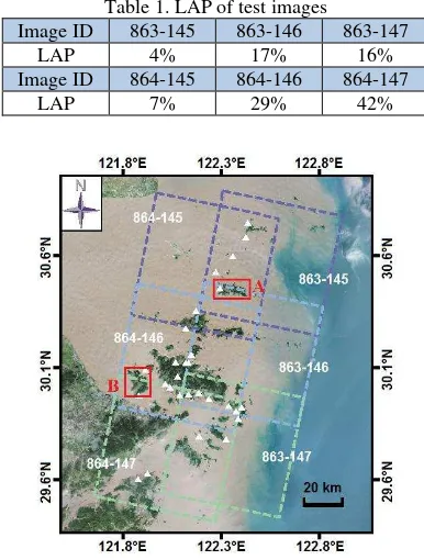
The performance of the proposed DEM extraction method is analysed using imagery data in ZhouShan area, which is located in Zhejiang province, in the east coast of China, around longitude 121.645°E to 122.921°E and latitude 29.411°N to 30.893°N, with the elevation ranging between 0m and 800m. There are six island and reef TLC images with different land area proportion (LAP), namely, the ratio of land area to image coverage area. Their LAPs are ranging from 4% to 42%, and as shown in Table 1. All test images were provided with RFM parameters. There are 29 independent checkpoints in study area, of which planimetric and vertical accuracy are superior to 0.1m and 0.2m, respectively. The ground coverage of test images and distribution of checkpoints are shown in Figure 2.
Table 1. LAP of test images
Image ID 863-145 863-146 863-147
LAP 4% 17% 16%
Image ID 864-145 864-146 864-147
LAP 7% 29% 42%
Figure 2 Distribution of experimental images and checkpoints
4.1 Feasibility Validation
The DEM extraction results of the test images with minimum and maximum LAP are shown in Figure 3.
As shown in Figure 3, this method can effectively extract DEM, regardless of the proportion of sea area in the image coverage, which indicates that it can avoid the adverse effect of the repeated texture of sea area image on image matching and DEM extraction. Therefore, the method can effectively solve the problem of island and reef DEM extraction.
4.2 Quantitative Analysis
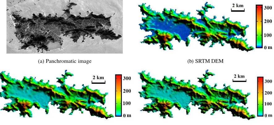
In order to analyse and compare the extracted DEM in detail, we select two islands in red box, as shown in Figure 2. Their panchromatic image, SRTM DEM and DEMs with two resolutions extracted by this method are shown in Figure 4 and Figure 5, respectively.
(a)863-145 (b)864-147
Figure 3. DEM extraction results of the test images with minimum and maximum LAP
(a) Panchromatic image (b) SRTM DEM
(c) TH-DEM (R=0.0009°) (d) TH-DEM (R=0.0005°)
Figure 4. Image and various DEMs of Island A
(a) Panchromatic image (b) SRTM DEM (c) TH-DEM (R=0.0009°) (d) TH-DEM (R=0.0005°)
Figure 5. Image and various DEMs of Island B
As shown in Figure 4 and Figure 5, this method can extract the island and reef completely, and the extracted DEMs are of good consistency with SRTM DEM in different terrain regions. For the two TH-DEMs, the TH-DEM with lower resolution (R=0.0009°) is close to SRTM DEM (R=0.00083°), which has less terrain detail information; the TH-DEM with higher resolution (R=0.0005°) includes more terrain details and is capable of expressing the surface more precisely.
4.3 DEM Accuracy Evaluation
In this section, the accuracy of the extracted TH-DEMs are quantitatively evaluated, and are compared with SRTM DEM, the evaluation results are shown in Figure 6.
Figure 6. Comparison of DEM accuracy
As shown in Figure 6, the elevation accuracy of the TH-DEMs with resolution close to SRTM DEM is slightly lower than the latter. In addition, the accuracy of TH-DEMs extracted from images with larger LAP is higher than that of with lower LAP. As for the TH-DEMs with higher resolution than SRTM DEM, the accuracy of each TH-DEM is consistent, part of TH-DEMs have higher accuracy than SRTM DEM and are all superior to 5.4m. It also suggests that the higher resolution TH-DEMs can better express the surface.
4.4 DEM Extraction Efficiency
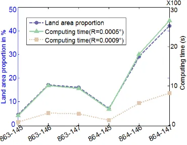
Figure 7 shows the DEM extraction computation time of the above two resolutions. All experiments were performed with the hardware and software environment of Intel i7-4720HQ 2.60GHz, 16GB RAM and Matlab R2014a.
Figure 7. Influence of land area proportion and DEM resolution on computational efficiency
Figure 7 shows that computational efficiency has a strong linear correlation with LAP, and the greater the LAP, the longer the computing time needed. In addition, the higher the resolution of TH-DEM, the longer the time required.
5. CONCLUSION
This paper proposes an SRTM DEM-aided DEM extraction method for island and reef based on TH-1 satellite image, which can effectively solve the problem of island and reef DEM extraction. The method can effectively avoid the adverse effect of the repeated texture of sea area image and can extract DEM from island and reef images regardless of the LAP. The extracted DEMs have rich terrain detail information and can precisely express the surface. The accuracy of extracted DEM
will be improved with higher resolution. When the resolution is relative high, the accuracy of the extracted DEMs is consistent with SRTM DEM and parts of them are even better than SRTM DEM. The computational efficiency depends on the DEM resolution and LAP, the higher the resolution or the larger the LAP, the longer the time needed.
ACKNOWLEDGEMENTS
This work was sponsored by the National Natural Science Foundation of China under Grant No. 41601507 and the Open Research Foundation of State Key Laboratory of Geo-information Engineering under Grant No. SKLGIE2015-M-3-3. The SRTM DEM data sets were provided by the International Centre for Tropical Agriculture (CIAT): http://srtm.csi.cgiar.org.
REFERENCES
Chen, X. W., B. M. Zhang, T. G. Zhang, H. T. Guo, and M. Y. Cen, 2016. Public DEM-assisted positioning method for Chinese satellite imagery without ground control points. Acta Geodaetica Cartograph. Sin., 45(11), pp. 1361-1370,1383.
Fraser, C. S., G. Dial, and J. Grodecki, 2006. Sensor orientation via RPCs. ISPRS J. Photogramm. Remote Sens., 60(3), pp. 182– 194.
Grodecki, J. and G. Dial, 2003. Block adjustment of high-resolution satellite images described by rational functions. Photogramm. Eng. Remote Sens., 69(1), pp. 59–68.
Kim, T. and J. Jeong, 2011. DEM matching for bias compensation of rigorous pushbroom sensor models. ISPRS J. Photogramm. Remote Sens., 66(5), pp. 692-699.
Reinartz, P., R. Müller , P. Schwind, S. Suri, and R. Bamler, 2011. Orthorectification of VHR optical satellite data exploiting the geometric accuracy of TerraSAR-X Data. ISPRS J. Photogramm. Remote Sens., 66(1), pp. 124-132.
Reuter, H. I., A. Nelson, and A. Jarvis, 2007. An evaluation of void filling interpolation methods for SRTM data. International Journal of Geographic Information Science, 21(9), pp. 983-1008.
Rodríguez, E., C. S. Morris, and Belz, J. E., 2006. A global assessment of the SRTM performance. Photogramm. Eng. Remote Sens., 72(3), pp. 249-260.
Satge, F., M. P. Bonnet, F. Timouk, S. Calmant, R. Pillco, J. Molina, W. L. Casimiro, A. Arsen, J. F. Cretaux, and J. Garnier, 2015. Accuracy assessment of SRTM v4 and ASTER GDEM v2 over the Altiplano watershed using ICESat/GLAS data. Int. J. Remote Sens., 36(2), pp. 465-488.
Schneider, M., S. Suri, M. Lehner, and P. Reinartz, 2012. Matching of high-resolution optical data to a shaded DEM. International Journal of Image and Data Fusion, 3(2), pp.111-127.
Wang, R. X., X. Hu, and J. R. Wang, 2013. Photogrammetry of Mapping Satellite-1 without ground control points. Acta Geodaetica Cartograph. Sin., 42(1), pp.1-5.