VOLUNTEERED GEOGRAPHIC INFORMATION (VGI) AND ENVIRONMENTAL
MONITORING, A NEW APPROACH IN DEVELOPING COUNTRIES
Mohsen Manouchehri a, *, Majid Kiavarz Moghaddam b
a Dept. of Urban and Regional Planning, College of Fine Arts, University of Tehran, Tehran, Iran - [email protected] b Dept. of Geomatics Engineering, Faculty of Engineering, University of Tehran, Tehran, Iran - [email protected]
KEY WORDS: Volunteered Geographic Information (VGI), Environmental Monitoring, Citizens’ Participation, Information Communication Technology (ICT), Facilitated VGI (F-VGI)
ABSTRACT:
Increasing world population and unprecedented expansion of urbanization in the world has caused many environmental problems. The relationship between man and the environment is bidirectional one that have great short-term and long-term impacts on the cities and regions. The best way to deal with it is the participation of the people themselves. The use of new technologies has now become one of the most important methods for monitoring the environment that can increase the participation of citizens, improving environmental problems to provide the cheapest and the most accessible form. Developing countries such as Iran, which faces enormous environmental problems are suitable for the development of technological methods of monitoring. Large population and citizens’ participation feasibility using VGI can have a positive effect on developing countries. Finally, by using F-VGI that ensures the validity and accuracy of data we can access an appropriate platform that leads us to suitable model for environment monitoring in the form of the application.
1. INTRODUCTION
Cities are strong units emphasis on knowledge innovation and cultural diversity. However, cities are sensitive at the same time according to basic input dependency on outside elements, such as food, water and energy. Natural or man-made disasters in city environments has negative influences on urban health. So, risk and resilience management has been a focus from academic and governmental sectors. Cities' liveability improve if people and governments pay more attention to pervasive range of man-made and natural environment pollutions based on geospatial databases and technologies (Bettencourt & West, 2010).
Modern cities are complicated systems and engines for the increasing of society development. At the same time, cities are consuming resources from nature and producing wastes to environments at a much higher rate than other lifestyles (Council, 2007). And because of this fast urbanization process in such a global scale, there is a severe need in academic research and practical fields for smart management and planning in the cities (Tao, 2013).
VGI is one of the newest topics in the GIS field. there are lots of opportunities for this field of research such as environmental protection, disaster management, etc. That shows VGI is maturing absolutely (Mooney, Sun, & Yan, 2011). There are many people will participate in the VGI contribution and formation. The mobile devices are a great parts of data collection because of diversity of multiple platforms (Song & Sun, 2010). In developed countries, VGI has been playing a key role in many application and important fields such as emergency management (Zook, Graham, Shelton, & Gorman, 2010), environmental monitoring, spatial planning (Poser & Dransch, 2010), crisis management (Stephane Roche, Propeck-Zimmermann, & Mericskay, 2013), and also collaborative procedure within Citizen Science initiatives (Haklay, 2013).
* Corresponding author
2. VGI AND PARTICIPATION
VGI could be considered as the spatial case of User generated content (UGC). UGC is the phenomenon where users generate content and information using Web 2.0 tools such as blogs, social networking, iterative media, collaborative projects, etc. Such has been the societal impact of UGC there is now a growing consensus to recognize the role that VGI has to play in areas such as: LBS, crisis and disaster management, environmental monitoring, and public participation in government (Mooney et al., 2011).
Nowadays, by new development of Web 2.0 technology, many governments are working on how they can better establish linkages with and accept citizen input online, specially through the gathering and use of volunteered geographic information (VGI). Two reasons drive the gathering and utilization of VGI by governments and government offices. To start with is the potential for natives, regardless of whether they reside inside or outside an offered jurisdiction, to act as sensors of their environment. Citizens as reference is questionable hold a valuable local knowledge of place, and considering that pride of place is a prime motivator of citizens who contribute geospatial data, they will probably volunteer that data in computerized shape. Citizen volunteer endeavours can be consolidated into a government procedure as a method for saving both the government money and utilizing the knowledge of citizens to support decision-making and management (Johnson & Sieber, 2013).
In terms of Volunteered Geographic Information(VGI) We are as of now confronting a quick increase in available data sources. We are seeing an expanding ability of individuals to contribute effectively on their own observations and comments in particular applications for a dedicated usage context, which can be subsumed under the broad term 'People as Sensors' (Sagl, Resch, Hawelka, & Beinat, 2012).
VGI can be profitable to governments as a form of citizen participation. Instead of the to the citizens-as-sensors view, this The International Archives of the Photogrammetry, Remote Sensing and Spatial Information Sciences, Volume XLII-4/W4, 2017
treats the process of VGI usage as an opportunity for citizens-as-partners to co-produce social, economic, and ecological objectives, with the mission of fortifying common society. For governments, an expanded concentrate on the procedure of VGI accumulation and two-way correspondence, as opposed to the unidirectional sensor relationship, can support essential participatory components of democratic governance Public participation is a vital part of collaborative environmental planning (Randolph, 2004). The popularity of global-positioning system (GPS) works in electronic gadgets drastically engages citizens to audit or transfer close-by geospatially particular environmental data (Tang & Liu, 2016).
3. VGI AND ENVIRONMENTAL MONITORING
Without other fast change identification and monitoring, which perpetually is postponed by days or even weeks, VGI turn out to be particularly critical. VGI is likewise turned out to be traditional sources of fundamental spatial information does not exist or not publicly accessible (Song & Sun, 2010). For VGI, and the bigger zone of citizen environmental monitoring, to wind up “mainstream and accepted " an urgent need for research to give systems to "limit information validity issues". A huge extent of developments happens outside of the authoritative or improvement control system. Therefore, the informal settlements increase the risk of man-made and natural disasters. There is awareness that local people must be engaged in the monitoring of growth and change. There is mindfulness that neighborhood individuals must be engaged with the monitoring of growth and change (Gouveia & Fonseca, 2008).
As new minimal effort sensors wind up noticeably accessible to quantify environmental factors, for example, climatic temperature, air quality, and soil moisture, VGI can possibly assume a significant part in natural checking and the collection of in-situ information (Fonte et al., 2015). Late advancements in information and communication technologies (ICT), for example, the social web and the scaling down of sensors, have made new chances to advance citizen participation in environmental monitoring. Open support in environmental monitoring has likewise profit by developments occurring in information and communication technologies (Gouveia & Fonseca, 2008).
Volunteers are one of the best assets for implementing environmental laws and controls. There is a developing enthusiasm to inspire volunteers and increment the productivity and social effect of observing. The internet, sensor technology and smart phones have mentioned it simple to record objective facts with stamps on position and time, and the correspondence with information has turned out to be brisk and simple. Volunteers need have some additional motive and if they don’t, we have seen that volunteers easily grow tired of observing. All monitoring systems and the citizen science in them have special cycle in their own life (Capineri et al., 2016).
Citizens can submit new informal settlements and illegal improvements, pollution incidents, traffic congestion hot spots, and crimes in a convenient way. Computerized and human sensors have as of now significantly enhanced capacities of environmental monitoring. It will increase the knowledge on the state of the environment at the same time it promotes citizens’ involvement in environmental protection. Using mobile cloud computing can facilitate data storage, investigation and dispersal. Particularly mobile cloud computing can deal with the big block data, like, images, sounds and videos in association with spatial information. People create and gather a large number of media substance for supporting diverse activities.
VGI can be considered as another chance of systems and sensors for monitoring urban and local environments. Especially in urban
conditions, the scope is great, on the grounds that numerous
2. Pollution of surface and ground water 3. Relief deformation
4. Soil degradation 5. Devastation of vegetation 6. Devastation in wild life 7. Pollution of seas and oceans
POLLUTION OF THE MAN-MADE (URBAN-INDUSTRIAL) ENVIRONMENT
1. Noise, vibrations, radiation
2. Garbage and municipal sewage (detergents) 3. Obnoxious odours
4. Post-production wastes (post-industrial wasteland) 5. Discarded durable objects (containers)
6. Ionizing radiation (radioactive substances and wastes)
SUBSTANDARD LIVING CONDITIONS
1. Substandard dwelling conditions 2. Substandard work conditions
Table 1: Environmental Pollutions and Degradations (Leszczycki, 1976)
4. FACILITATED VGI (F-VGI)
This variant of VGI, facilitated-VGI (f-VGI), is characterized by the use of online mapping interfaces that allow the public to individually or collaboratively contribute information to be located on a map. This information might be contributed in response to a predefined set of criteria, such as an explicitly defined question, or limited to an established geographic extent (Seeger, 2008).
VGI and Web 2.0 technologies have also been incorporated into a scope of environmental monitoring projects, which expressed that the purpose of monitoring should be to test from the earlier hypotheses and not just to create a progression of perceptions that can be utilized to produce post hoc hypotheses. Others have agreed that monitoring should be hypothesis driven and that monitoring ought to be seen as a systematic program that is set up to assist in the evaluation of the effects of a given human activity or set of activities on the environment or on a particular ecosystem. Surveillance monitoring programs are relatively simple and modest to set up and have the potential to generate large quantities of VGI (and may additionally provide highly tangible benefits in the form of public education and awareness). For VGI to generate large sample sizes and cover a wide geographic scope. Survey protocols can be developed and shared online. Advocates of VGI emphasize that its quality lies in people giving data on locations that are personally important. From an experimental perspective then, it can be difficult to set up observations in "treatment" and "control" areas because there may be little top-down control of how the data are gathered Facilitated VGI observation monitoring. One of the greatest benefits of VGI is the potential for an expansive number of perceptions to be generated, so there might be adequate replication to detect significant trends (Wiersma, 2010). The International Archives of the Photogrammetry, Remote Sensing and Spatial Information Sciences, Volume XLII-4/W4, 2017
5. HOW VGI AND ICT CAN HELP ENVIRONMENTAL MONITORING?
Subjects are changed from consumers of data into makers of data (prosumers) this new type of support and volunteer generation of nearby learning through ICT, despite the fact that it remains exclusionary because of its dependence on ICT access. Because of the high level of unpredictability of urban issues, information and communication technologies (ICTs) have for some time been
utilized to encourage researchers and professionals to deal with the urban foundations and enhance the proficiency of many working systems (Tao, 2013). This development is closely related to technological developments, enabling vast harvesting of volunteered information. Goodchild lists a number of features which are crucial in enabling a new era of VGI: access to GPS technologies, geo-referencing and tagging, dynamic graphics and broadband communication (Goodchild, 2008).
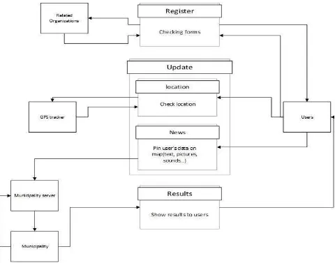
Figure 1: Conceptual framework for F-VGI based environmental monitoring
Examples of this spatial data concept are environmental monitoring carried out by citizens equipped with sensors. The appropriated way of VGI can possibly together articulate issues and perspectives on the urban condition, by tapping in on citizens’ own spatial data (Knudsen & Kahila, 2012). There are a few cases of VGI and "humans as sensors" in the Indian context. Fixourcity.org encourages volunteers in reporting problems with their respective geographic location and forwards the report to the nearby authority (Pfeffer, Martinez, Baud, & Sridharan, 2011).
In response to these mechanical advancements and merging’s, local governments have been additionally receiving ICTs for different urban improvement ventures (Shin & Shin, 2012). 21st-century digital world requires all knowledge (sounds, images, texts . . .) to be formalized ‘in a code of just two symbols, 0 and 1’. (Stéphane Roche, 2014) VGI can appear as tags, content, video, images or audio that is connected to a
spatial reference and contributed inside an openly available online environment (Ricker, Johnson, & Sieber, 2013). Tagging is a simple way to get data from clients concerning urban phenoma of a city. Individuals as sensors like the labelling approach, clients have the likelihood to present their own impression of a circumstance. If the user wants to be instantly informed about the measurements, the gathered datasets need to pre-processed, orchestrated and checked continuously (Zeile et al., 2015).
A simple to-utilize instrument, fast to get to and not connected to specific imperatives is important to guarantee a powerful commitment. On the platform, the local publication staff proposes themes of dialog by distributing particular articles; citizens are welcome to report about particular cases of scenes, with pictures, literary remarks and geolocalization on maps. No specialization is required to benefactors That is to state, web 2.0 is made of users. This perspective is more effective in the event that we consider that client's commitments may be The International Archives of the Photogrammetry, Remote Sensing and Spatial Information Sciences, Volume XLII-4/W4, 2017
content as well as mixed media data, or in the field of topographical information, geological contributes web 2.0 will develop and that this advancement must be joined by the utilization of new innovations and the entire utilization of all channels to convey data and to offer web services (Garnero, Corrias, Manigas, & Zedda, 2013). Using the Geoweb was threefold. To start with, we requested reactions in regards to environmental changes and tourism impacts. Besides, we concentrated on how non-specialists utilized a particular Geoweb device to report the effects. Through cooperation with the Geoweb during this exploration, the members were welcome to specifically enter their perceptions and information into an online interactive map. Thirdly, these members figured out how to utilize another product that is accessible for nothing out of pocket on the web, and can be repurposed to an assortment of tasks (Ricker et al., 2013).
6. F-VGI AND ENVIRONMENTAL MONITORING:
USING ICT
Involving citizens and empowering citizens in environmental and policy-makers is viewed as progressively critical by researchers and approach creators, expecting to enhance our chances to watch, comprehend and take associative activities to secure the earth. In any case, there is no agreement on the most proficient method to build up this idea in view of the resident's immediate commitments, nor is there any accord on what a Natives' Observatory is and what comes about it ought to produce. It ended up plainly workable for the normal citizen to decide position precisely, without the expert ability that had previously been limited to trained surveyors. VGI might be delivered a great deal more rapidly, and may catch changes in the landscape nearly as quick as they happen. The normal citizen is equipped with powers of observation, and is currently enabled with the capacity to georegister those observations, to transmit them through the internet, and to synthesize them into promptly comprehended maps and status reports (Goodchild & Glennon, 2010).
Informing applications retrieves information from the surrounding environment, which it then displays to the citizens with a specific end goal to help them in their everyday activities. This classification is divided into two subtypes: prepopulated apps and reporting apps. In the second subtype, reporting apps, citizens monitor the states of the earth and transfer photographs into the application. The geo- user input is used by the organization managing the app for undertaking operational tasks, for instance fixing broken things Citizens moving around the city detect and create data with the help of sensors in their mobile devices, mostly GPS positioning and cameras. These data are caught, stored in the app and transmitted to the cities’ internal back-end systems, where service needs are registered and solved. These applications additionally enable citizens to track the advance of their postings empower governments to know 'what is occurring on the ground'. These applications can give down to earth data, which governments can use in service delivery, on the off chance that they are eager and prepared to investigate and utilize the data (Ertiö, 2015).
7. CONCLUSION
By Using F-VGI capabilities and advantages that can greatly meet the accuracy and credibility of data we can get the application structure that is drawn. The drawn structure asks for user’s required information during the registration. Information’s such as name, postal code etc. and the information’s received from registry office or relevant
organization and the entrance permission issues for user to enter the main part and user by using his/her smart phone ables to document the specific location and environmental disaster by using images, text and … and register the exact location by pinning it on the map and sends it to the municipality or any organizations that is responsible for and the following results will inform the user.
However, there will be some problems in the accuracy and credibility of VGI data that can be minimize with few techniques. Increase the motivation of citizens to participate can increase that associated by which false data participation will be corrected itself (Zook et al., 2010). The other method is first offer users to fill a registration form in which they can register their information (Composto et al.; Wiersma, 2010). Such as postal code, name etc. or we can obtain further information from organs such as Registration. The other challenge that we encounter with is how we can motivate older people to use the application that of course can improved by necessary trainings.
ACKNOWLEDGEMENTS
Special thanks to The University of Tehran Science and Technology Park for supports.
REFERENCES
Bettencourt, L., & West, G. (2010). A unified theory of urban living. Nature, 467(7318), 912-913.
Capineri, C., Haklay, M., Huang, H., Antoniou, V., Kettunen, J., Ostermann, F., & Purves, R. (2016). European Handbook of Crowdsourced Geographic Information: Ubiquity Press: London, UK. Composto, S., Ingensand, J., Nappez, M., Ertz, O., Rappo, D.,
Bovard, R., . . . Joost, S. How to recruit and motivate users to utilize VGI-systems?
Council, N. R. (2007). Successful response starts with a map: improving geospatial support for disaster management: National Academies Press.
Ertiö, T.-P. (2015). Participatory apps for urban planning— space for improvement. Planning Practice & Research, 30(3), 303-321.
Fonte, C., Bastin, L., Foody, G., Kellenberger, T., Kerle, N., Mooney, P., . . . See, L. (2015). VGI quality control. ISPRS Geospatial week 2015, 317-324.
Garnero, G., Corrias, A., Manigas, L., & Zedda, S. V. (2013). VGI, augmented reality and smart web application: projects of development in the territory of the Sardinia region. Paper presented at the International Conference on Computational Science and Its Applications.
Goodchild, M. F. (2008). Commentary: whither VGI? GeoJournal, 72(3), 239-244.
Goodchild, M. F., & Glennon, J. A. (2010). Crowdsourcing geographic information for disaster response: a research frontier. International Journal of Digital Earth, 3(3), 231-241.
Gouveia, C., & Fonseca, A. (2008). New approaches to environmental monitoring: the use of ICT to explore volunteered geographic information. GeoJournal, 72(3-4), 185-197.
Haklay, M. (2013). Citizen science and volunteered geographic information: Overview and typology of participation Crowdsourcing geographic knowledge (pp. 105-122): Springer.
Johnson, P. A., & Sieber, R. E. (2013). Situating the adoption of VGI by government Crowdsourcing geographic knowledge (pp. 65-81): Springer.
Knudsen, A.-M. S., & Kahila, M. (2012). The role of Volunteered Geographic Information in participatory planning. Examples from Denmark and Finland. Geoforum Perspektiv, 11(21). Leszczycki, S. (1076). Environment Maps. Geographica
Polonica nr 33, pp 19-25.
Mooney, P., Sun, H., & Yan, L. (2011). VGI as a dynamically updating data source in location-based services in urban environments. Paper presented at the Proceedings of the 2nd international workshop on Ubiquitous crowdsouring.
Pfeffer, K., Martinez, J., Baud, I., & Sridharan, N. (2011). Knowledge production in urban governance systems through qualitative geographical information systems (GIS). Environment and Urbanization Asia, 2(2), 235-250.
Poser, K., & Dransch, D. (2010). Volunteered geographic information for disaster management with application to rapid flood damage estimation. Geomatica, 64(1), 89-98.
Randolph, J. (2004). Environmental land use planning and management: Island Press.
Ricker, B. A., Johnson, P. A., & Sieber, R. E. (2013). Tourism and environmental change in Barbados: gathering citizen perspectives with volunteered geographic information (VGI). Journal of Sustainable Tourism, 21(2), 212-228.
Roche, S. (2014). Geographic Information Science I Why does a smart city need to be spatially enabled? Progress in Human Geography, 38(5), 703-711.
Roche, S., Propeck-Zimmermann, E., & Mericskay, B. (2013). GeoWeb and crisis management: Issues and perspectives of volunteered geographic information. GeoJournal, 78(1), 21-40.
Sagl, G., Resch, B., Hawelka, B., & Beinat, E. (2012). From social sensor data to collective human behaviour patterns: Analysing and visualising spatio-temporal dynamics in urban environments. Paper presented at the Proceedings of the GI-Forum.
Seeger, C. J. (2008). The role of facilitated volunteered geographic information in the landscape planning and site design process. GeoJournal, 72(3-4), 199-213.
Shin, Y., & Shin, D.-H. (2012). Community informatics and the new urbanism: Incorporating information and communication technologies into planning integrated urban communities. Journal of Urban Technology, 19(1), 23-42.
Song, W., & Sun, G. (2010). The role of mobile volunteered geographic information in urban management. Paper presented at the Geoinformatics, 2010 18th International Conference on.
Tang, Z., & Liu, T. (2016). Evaluating Internet-based public participation GIS (PPGIS) and volunteered geographic information (VGI) in environmental planning and management. Journal of Environmental Planning and Management, 59(6), 1073-1090.
Tao, W. (2013). Interdisciplinary urban GIS for smart cities: advancements and opportunities. Geo-spatial Information Science, 16(1), 25-34.
Wiersma, Y. (2010). Birding 2.0: citizen science and effective monitoring in the Web 2.0 world. Avian Conservation and Ecology, 5(2).
Zeile, P., Resch, B., Dörrzapf, L., Exner, J.-P., Sagl, G., Summa, A., & Sudmanns, M. (2015). Urban Emotions–tools of integrating people’s perception into urban planning. Paper presented at the REAL CORP 2015. PLAN TOGETHER–RIGHT NOW– OVERALL. From Vision to Reality for Vibrant Cities and Regions. Proceedings of 20th International Conference on Urban Planning, Regional Development and Information Society. Zook, M., Graham, M., Shelton, T., & Gorman, S. (2010).
Volunteered geographic information and crowdsourcing disaster relief: a case study of the Haitian earthquake. World Medical & Health Policy, 2(2), 7-33.