RELATIONSHIP BETWEEN THE ELLISVILLE PLUTON AND CHOPAWAMSIC FAULT: ESTABLISHMENT OF SIGNIFICANT
LATE ORDOVICIAN FAULTING IN THE APPALACHIAN PIEDMONT OF VIRGINIA
K. STEPHEN HUGHES*,†, JAMES P. HIBBARD*, and BRENT V. MILLER**
ABSTRACT. The Chopawamsic fault is the most significant boundary in the western Piedmont of north central Virginia; it separates the metaclastic Early Ordovician or older Potomac terrane of Laurentian affinity from the dominantly metavolcanic Middle to Late Ordovician Chopawamsic terrane of unknown cratonic heritage. On regional maps, the Ellisville pluton had previously been depicted as stitching the Chopawamsic fault, although this relationship has never been documented. It has been hypothesized that the Chopawamsic fault marks the suture of the early Paleozoic Iapetus Ocean, which once separated Laurentian and Gondwanan crustal elements. Consequently, it is important to examine the stitching relationship in detail in order to place timing constraints on motion along this fault. We integrate detailed field mapping, kinematic analysis, petrography, major-oxide, trace, and rare earth element geochemistry, and U-Pb zircon geochronology in order to deduce the relationships between the Ellisville pluton, the Chopawamsic fault, and thus, the Potomac and Chopawamsic terranes in central Virginia.
Our study reveals local textural and minor geochronologic variations in the Ellisville pluton, whereas composition and geochemistry are mostly homogenous throughout the body. These data, along with 1:24,000 scale mapping, collectively confirm that the Ellisville pluton stitches the Potomac and Chopawamsic terranes across the Chopawamsic fault. New U-Pb zircon geochronological analyses yield ages ofca.444 Ma andca.437 Ma, and indicate that the latest significant movement of the fault occurred before a 443.7ⴞ3.3 Ma main phase of magmatism present throughout the Ellisville pluton. These dates, with previously determined crystallization ages from the Chopawamsic terrane, constrain significant movement on the Chopawamsic fault to aca.10 million year interval in the Late Ordovician between ca.453 to 444 Ma. Whether the accretion of the Chopawamsic terrane involved the closing of either a back-arc seaway or a global ocean has yet to be determined; however, based on its timing and kinematic nature, we suggest that the development of the Chopawamsic fault may be related to the Late Ordovician to Early Silurian Cherokee orogeny.
Key words: Appalachian Piedmont, stitching pluton, Chopawamsic fault, Ellisville pluton
introduction
The Chopawamsic fault separates the two principal crustal components within the western Piedmont of north central Virginia (fig. 1), including the Potomac terrane to the west and the Chopawamsic terrane to the east (for example: Pavlides, 1989, 1990; Horton and others, 1989; VDMR, 1993; Pavlides and others, 1994; Pavlides, 1995; Mixon and others, 2000; Mixon and others, 2005; Hibbard and others, 2013). It has been hypothesized that this significant fault could represent the main Iapetan suture in the southern Appalachians because it separates the metaclastic Potomac terrane, commonly interpreted to be an accretionary complex of Laurentian affinity from the
* Department of Marine, Earth, and Atmospheric Sciences, North Carolina State University, Raleigh, North Carolina 27695-8208, USA; jphibbar@ncsu.edu
** Department of Geology and Geophysics, Texas A&M University, College Station, Texas 77843-3115, USA; bvmiller@geo.tamu.edu
†Corresponding author: kshughes@ncsu.edu; kstephenhughes@gmail.com
[American Journal of Science, Vol.313, June,2013, P.584 – 612, DOI 10.2475/06.2013.03]
Chopawamsic terrane, a magmatic arc of unknown, but potentially peri-Gondwanan origin (Hibbard and others, 2007, 2013).
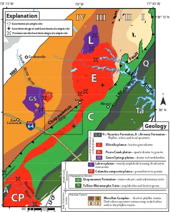
Regional studies depict the Ellisville granodiorite as a stitching pluton across the Chopawamsic fault near Louisa, Virginia (fig. 2), (Glover, 1989; Pavlides, 1989; Horton and others, 1991; VDMR, 1993; Sinha and others, 2012) although no previous detailed mapping has been undertaken to substantiate such interpretations. Evaluation of this purported cross-cutting relationship is the main focus of this study. If the Ellisville pluton cross-cuts the Chopawamsic fault, its crystallization age can be used to constrain the timing of latest movement along this regionally significant structure. To assess the stitching nature of the Ellisville pluton, the tail of the pluton was mapped in detail in the area where reconnaissance maps have previously shown it to cross the Chopawam-sic fault. We use our mapping, along with new petrographic, geochemical, and modern thermal ionization mass spectrometry (TIMS) geochronological analyses, and data from previous studies to assess the potential stitching nature of the Ellisville pluton.
In addition to constraining fault timing, our detailed mapping in the vicinity of the pluton tail enables us to evaluate sparsely exposed kinematic indicators along the Chopawamsic fault. Considering that the Chopawamsic fault separates the Laurentian Potomac terrane from the Chopawamsic terrane of unknown crustal affinity, constrain-ing the timconstrain-ing and kinematics of the fault is a critical and necessary first step towards clarifying the tectonic history of the region and evaluating whether the fault represents the main Iapetan suture or merely structural telescoping of a Laurentian arc system.
regional setting
The Chopawamsic fault trends northeasterly for more than 100 km through central Virginia (figs. 1 and 2), where it has generally been depicted as a thrust on the basis of seismic data and limited field observations (Harris and others, 1982, 1986; Pavlides, 1989, 1990, 1995; Horton and others, 1989; Pavlides and others, 1994; Mixon and others, 2000, 2005). Available seismic data (I-64 line: Harris and others, 1982, 1986; Keller and others, 1985; and Pratt and others, 1988) indicate that the fault dips steeply to the southeast at the surface and more shallowly at depth, placing the Chopawamsic terrane structurally above the Potomac terrane. It is unclear if the
R
Virginia Western Piedmont
SRA M
C P
Valley and Ridge
Mesozoic Culpeper and Danville Basins and related rocks (Tr).
Ordovician to Early Silurian intrusive bodies. Red = felsic. Purple = mafic.
Ordovician rocks of the Chopawamsic Terrane (C) and Milton Terrane (M).
Cambrian to Ordovician rocks of the Potomac Terrane (P) and Smith River Allocthon (SRA).
Co astal Plain
Appalachian Plateau E.
Piedmon t Blue Ridge
Tr
Tr
Area of
Figure 2
Bsz Cf
OP
Geology modified from Hibbard and others, 2006. R = Richmond, Bsz = Brookneal Shear zone, Cf = Chopawamsic fault, OP = Occoquan pluton.
Fig. 1. Regional geology of the western Piedmont of Virginia.
585
attitude of the fault represents an original geometry or is a result of subsequent deformation (Pavlides, 1989, 2000). Seismic data to the west of Louisa, VA, (PR-3 line: Lampshire and others, 1994) lack any indication of the Chopawamsic fault; thus, the
LFCF
Latest Ordovician to Early Silurian
Columbia composite pluton-- granodiorite to granite
Ellisville pluton-- biotite granodiorite
Q = Quantico Formation, A = Arvonia
Formation--Phyllite, schist, and local quartzite
Mine Run Complex-- block in phyllite matrix. Dark inliers represent various map scale bodies within the phyllite matrix.
Chopawamsic Formation-- meta-volcanic and sedimentary rocks
Ta River Metamorphic Suite-- amphibolite and biotite gneiss
Ta
GS Green Springs pluton-- diorite to hornblendite
Poore Creek pluton-- quartz diorite to granite
L Lahore pluton-- mostly amphibole-bearing shoshonitic
monzonite
Geology
Chopawamsic Terrane Geochemical sample site
Geochronological and Geochemical sample site
Previous works Geochronological sample site
Fig. 2. Simplified geologic map of the Ellisville pluton and vicinity. Geochemical and geochronological sample sites in Ellisville pluton and Columbia pluton are shown. Rectangle south of Louisa outlines the north half of the Ferncliff 7.5⬘quadrangle. Abbreviations not explained in the legend are: LBF⫽Long Branch Fault, LFCF⫽ Little Fork Church fault, MRF⫽ Mountain Run fault. Geology modified after Hopkins, ms, 1960; Smith and others, 1964; Glover and Tucker, 1979; Duke, ms, 1983; Pavlides, 1989; Rossman, 1991; VDMR, 1993; Pavlides and others, 1994; Mixon and others, 2000; Spears and Bailey, 2002; Bailey and others, 2005; Hughes, 2011; and our own reconnaissance. Zircons from previous geochronologi-cal sample sites for the Lahore, Ellisville, and Green Springs/Poore Creek bodies were combined to obtain an age for each body (Pavlides and others, 1994; Wilson, ms, 2001; Sinha and others, 2012).
fault must lie at or to the east of this locale. South of the Appomattox River, the fault may have been multiply reactivated as part of the Alleghanian Brookneal ductile shear zone (fig. 1) (Gates, ms, 1986, 1997; Bailey and others, 2004). The presence of the Chopawamsic fault remains unclear to the north of the Occoquan River, but it is inferred to separate the Early-Middle Ordovician Occoquan granite (fig. 1), which intrudes the Potomac terrane, from the Chopawamsic terrane (Heimgartner, ms, 1995; Horton and others, 2010).
The metaclastic Potomac terrane (Drake, 1989; Horton and others, 1989) in north-central Virginia is comprised chiefly of the mainly metaclastic Mine Run Complex (Pavlides, 1989) that has been divided into four zones on the basis of geophysical characteristics and exotic block content, and is numbered from east to west as units I through IV (fig. 2). The complex has been thought to be correlative with the Hardware metagraywacke and Shores me´lange at the James River (Pavlides, 1979; Evans, ms, 1984; Brown, 1986; Hibbard and others, 2013), and the Lunga Reservoir and Sykesville meta-diamictite formations in northern Virginia and Maryland (Pav-lides, 1989). Age constraints for the Potomac terrane are derived from U-Pb geochrono-logical analyses of cross-cutting plutonic bodies, regional correlation, assumed age relationships of metavolcanic blocks within the Mine Run Complex, and detrital zircon analyses. The oldest documented intrusion into the Mine Run Complex is theca.456 Ma Goldvein pluton (Aleinikoff and others, 2002), indicating that the complex is Late Ordovician or older. Rocks of the Lunga Reservoir metadiamictite, interpreted to be correlative to the Mine Run Complex, are intruded by theca.472 Ma Occoquan pluton (Aleinikoff and others, 2002), indicating that the Potomac terrane in northernmost Virginia is Early Ordovician or older. Pavlides (1989) interpreted volcanic blocks in the Mine Run Complex to be derived of the Chopawamsic Formation to the east, which suggests that the Mine Run Complex is either younger or coeval with some Middle– Late Ordovician rocks of the Chopawamsic Formation. In contrast, Horton and others (2010) found that the Sykesville Formation, a correlative of the Mine Run Complex, included an abundant population of Mesoproterozoic zircons, but lacked any Ordovi-cian detrital zircons potentially derived from the Chopawamsic Formation. Thus, it seems the correlation of blocks in the Mine Run Complex to the Chopawamsic Formation, although geographically convenient, may be inappropriate. Rocks of the Potomac terrane and their correlatives are interpreted to be of Laurentian affinity on the basis of spatial relations with Laurentian rocks immediately to the west (Drake, 1989; Pavlides, 1989), depositional inter-fingering with known Laurentian strata (Evans, ms, 1984), and detrital zircon data from equivalent rocks in south-central Virginia (Carter and others, 2006; Bailey and others, 2008) and Maryland (Horton and others, 2010). On the basis of existing information, the Potomac terrane has been interpreted to represent an early Paleozoic accretionary complex that formed between the Chopawamsic volcanic arc terrane and Laurentia (Drake, 1989; Pavlides, 1989; Horton and others, 1989; Hibbard and others, 2013).
The Chopawamsic terrane (Williams and Hatcher, 1982, 1983; Horton and others, 1989), also referred to as a portion of the central Virginia volcanic and plutonic belt (Pavlides, 1981), consists of greenschist facies metavolcanic and metavolcaniclastic rocks of the Chopawamsic Formation (Southwick and others, 1971) as well as higher grade amphibolite and gneiss of the coeval Ta River Metamorphic Suite (Pavlides, 1981). Rocks of the Chopawamsic Formation in central Virginia have previously been referred to as the Cohasset volcanics (Brown, 1976; Bland, ms, 1978; Bland and Blackburn, 1980) although this name has fallen out of use. The Chopawamsic Formation extends for more than 150 km along strike and has been mapped as far south as the Appomattox River (Marr, 1980a, 1980b). Recognition of the formation throughout the western Piedmont has been based on compositional similarities and 587
geophysical characteristics (Pavlides and others, 1974). Metavolcanic rocks of the Chopawamsic Formation in central Virginia are dated at 471.4⫾1.3 Ma (U-Pb zircon, Coler and others, 2000) and in northern Virginia, a volcanic unit interpreted to be near the top of the Chopawamsic Formation yields an age of 453⫾4 Ma (U-Pb zircon, Horton and others, 2010). The apparent range in Chopawamsic volcanic ages indi-cates either a 15 to 20 Ma duration of volcanism, or perhaps at least two discrete phases of Chopawamsic volcanism (Horton and others, 2010; Sinha and others, 2012; Hib-bard and others, 2013). The Chopawamsic terrane has been interpreted to represent a suprasubduction magmatic island arc that developed over some form of Mesoprotero-zoic continental crust (Pavlides, 1981; Coler and others, 2000). The paleogeographic affinity of the Chopawamsic terrane has not been identified and the probable presence of Mesoproterozoic basement to the Chopawamsic terrane (Coler and others, 2000) is ambiguous in terms of provenance; however, two arguments may indicate a peri-Gondwanan origin (Hibbard and others, 2007). First, the Chopawamsic arc is overlain by black slate and phyllite of the Latest Ordovician–Silurian Arvonia and Quantico successor basins, a common feature of the peri-Gondwanan Iapetan arcs in the northern Appalachians (Williams and others, 1988). Secondly, Pb isotopic composi-tions of volcanic-hosted massive sulfide deposits in the Chopawamsic terrane are relatively radiogenic (Pavlides and others, 1982a; Swinden and others, 1988) and identical to those of peri-Gondwanan volcanic-hosted massive sulfide deposits of the northern Appalachians. In addition, unpublished detrital zircon data from one sample suggest that the successor basins, in some places interpreted to be interlayered with the Chopawamsic Formation (Southwick and others, 1971; Horton and others, 2010), have a Gondwanan provenance (Bailey and others, 2008). However, these data are not sufficient to rule out the possibility of Laurentian provenance, and the origin of the Chopawamsic terrane remains suspect (Hibbard and others, 2013).
Both the Potomac and Chopawamsic terranes are intruded by various Ordovician-Early Silurian plutons (for example: Wilson, 2001; Aleinikoff and others, 2002; Horton and others, 2010; Sinha and others, 2012) that can be divided into three broad classes (Hibbard and others, 2013). A collection of peraluminous granites mostly intrudes the Potomac terrane in northern Virginia while an assortment of arc-related granite-tonalite intrudes only the Chopawamsic terrane. Theca.444 Ma (U-Pb zircon, this study) Ellisville granodiorite, has been assigned to a third set—the gabbroic-granitic complexes— based upon its spatial and temporal relationship with the ca.
451/446 Ma (Wilson, ms, 2001; Sinha and others, 2012) shoshonitic Lahore monzo-nite (fig. 2). The nearby Green Springs diorite and Poore Creek Gramonzo-nite (Hopkins, ms, 1960; Rossman, 1991; fig. 2), which have a combined age of 448⫾3 Ma (Wilson, ms, 2001) and/or 432⫾7 Ma (Sinha and others, 2012), are part of this gabbroic-granitic group as well.
The southern portion of the Chopawamsic fault lies within an area of intermittent moderate earthquake activity known as the Central Virginia Seismic Zone (for ex-ample: Bollinger and Sibol, 1985; Kim and Chapman, 2005; Tarr and Wheeler, 2006). Rupture of the Mw5.8, August 23, 2011 Mineral, Virginia earthquake occurred along a structure that cuts through the Chopawamsic terrane (Bailey and Owens, 2012; Horton and others, 2012a, 2012b; Pratt, 2012; Spears, 2012; Spears and Gilmer, 2012). This structure does not correspond to the Chopawamsic fault, but may have been facilitated by relict Paleozoic features internal to the Chopawamsic terrane (Hughes and Hibbard, 2012a, 2012b).
previous work
In the past, geologists have mapped the Potomac-Chopawamsic terrane boundary as a non-faulted contact (for example: Lonsdale, 1927; Hopkins, ms, 1960; Southwick and others, 1971; Conley and Johnson, 1975; Seiders and others, 1975; Pavlides, 1976,
1981; Conley and Marr, 1980; Marr, 1980a, 1980b; Seiders and Mixon, 1981; Pavlides and others, 1982a). However, the presence of the Chopawamsic fault has been supported by the following evidence: aeromagnetic and aeroradioactive data (Neuschel, 1970), seismic profiles (Harris and others, 1982, 1986; Keller and others, 1985; Pratt and others, 1988), reported shear fabric at multiple locations along the contact (Brown, 1979; Pavlides, 1989, 2000), regional mapping (Duke, ms, 1983; Evans, ms, 1984; Wehr and Glover, 1985; Brown, 1986; Glover, 1989; Marr, 1990), disparate detrital zircon suites from the terranes astride the fault (Hughes and others, 2012a), and the juxtaposition of compositionally and structurally distinct lithotectonic masses of rock. Most workers who have depicted the interface as a fault generally infer that it is a thrust, although this interpretation has not been confirmed by kinematic studies.
The Ellisville pluton (Hopkins, ms, 1960) outcrops over an area of⬃210 km2and consists mostly of medium-grained biotite-granodiorite which commonly retains a primary porphyritic texture with euhedral orthoclase and microcline feldspar crystals up to 3 cm long. The main body is semi-tabular in three dimensions, and lies mostly within rocks of the Mine Run Complex, although a contact metamorphosed thermal aureole of biotite, muscovite, margarite, chloritoid, staurolite, kyanite, and fibrolite reportedly extends eastward across the Chopawamsic fault and into the Chopawamsic Formation (Pavlides, 1989; Pavlides and others, 1994). Until this study, the report of contact metamorphism across the Chopawamsic fault provided the strongest support-ing evidence for the stitchsupport-ing nature of the Ellisville pluton. Pavlides and Cranford (1982) recognized that the main body of the Ellisville pluton is a compositionally homogenous yet texturally composite (variations in crystal size) intrusion composed of two pulses of magmatism including: (1) a dominant, main phase of medium-grained, porphyritic biotite granodiorite, and (2) a subsidiary, younger fine-grained biotite granodiorite. The younger phase has only been observed at outcrop scale and thus, has not been depicted upon previous regional or local maps. The porphyritic phase of the pluton makes up the vast majority of the pluton. Both phases of the intrusion are heterogeneously deformed, ranging from massive to moderately foliated. No system-atic distribution of deformation has been recognized or reported in the pluton. Geochemical analyses from the main body indicate that the pluton is calc-alkaline and weakly peraluminous (Pavlides and others, 1994). Previous geochronological data for the main body of the pluton include dates of 444⫾6 Ma (U-Pb zircon, Wilson, ms, 2001), 441⫾3 Ma (U-Pb zircon, Sinha and others, 2012), 438⫾10 Ma (Pb-Pb multiple zircon populations, Pavlides and others, 1994) and 441⫾ 8 Ma (Rb-Sr whole rock, Pavlides and others, 1982b), but it is unclear how these dates relate to the two observed magmatic phases of the pluton. Seven strontium isotope analyses from the Ellisville pluton reported by Pavlides and others (1994) have an average initial87Sr/86Sr value of .70613 when calculated at 444 Ma. This ratio is similar to the87Sr/86Sr value of .70614 for the nearby Poore Creek granite (at 448 Ma; Wilson, ms, 2001); both values indicate some evolved crustal material was included in the magma for each body. The Ellisville pluton has been estimated to have been emplaced at 0.6 to 0.45 GPa, a depth of 18 to 13 km (Pavlides and others, 1994).
At regional scale, the southern tail of the Elllisville pluton has been interpreted to cross-cut the Chopawamsic fault near Louisa, Virginia (Pavlides, 1979; Duke, ms, 1983; Evans, ms, 1984; Pavlides, 1989; Horton and others, 1991; VDMR, 1993; Pavlides and others, 1994; Sinha and others, 2012). The two-dimensional map pattern of the Ellisville pluton may at first resemble some macro-porphyroclast feature, however, the noticeable magnetic and gravity trace of the pluton tail continues northward into the main body, suggesting that the tail of the pluton may represent a feeder dike to the sheet like main body of the pluton (Pavlides and others, 1994). The only other specific references to SW-NE trending tail are by Hopkins (ms, 1960) as more “gneissic” than 589
the main body and by Duke (ms, 1983) as the “southern sill” portion of the Ellisville granodiorite. Specific to the tail of the pluton, Hopkins (ms, 1960) mapped small bodies of hornblende meta-gabbro at and near the eastern margin of the tail of the pluton; due to their position within the tail, these small bodies may be the result of localized assimilation of mafic schists from the adjacent Chopawamsic Formation country rock.
Many geologists have linked the tail of the Ellisville pluton to the nearby Columbia composite pluton (fig. 2). Multiple configurations of the Ellisville-Columbia relation-ship have been proposed, including the following: (1) connection of the two bodies via the Ellisville tail (VDMR, 1963; Good and others, 1977; Duke, ms, 1983; Spears and Bailey, 2002); (2) referring to parts of the Columbia pluton as the Ellisville pluton (Conley and Johnson, 1975; Conley, 1978; Duke, ms, 1983); and (3) mapping a northern extension of the Columbia pluton towards the tail of the Ellisville pluton (Taber, 1913; Jonas, 1932; Smith and others, 1964; Bailey and others, 2005). The northwestern porphyritic granodiorite phase of the Columbia pluton (Goodman and others, 2001; Koteas and others, 2002; Bailey and others, 2005), formerly called the Carysbrook pluton and mapped by some geologists to be independent from the Columbia pluton (Stose and Stose, 1948; VDMR, 1993), is compositionally similar to the bulk of the Ellisville pluton. The Columbia pluton, dated at 457⫾7 Ma at its type locality (U-Pb zircon, Wilson, ms, 2001), intrudes the Chopawamsic terrane (Bourland and Glover, 1979; Goodman and others, 2001; Bailey and others, 2005). The northwest-ern (Carysbrook) phase of the pluton has a poorly constrained age of 444⫾ 11 Ma (U-Pb zircon, Sinha and others, 2012) and may indicate that this area crystallized coevally with the Ellisville pluton. The probable link between the Columbia pluton (intrusive to the Chopawamsic terrane) and the Ellisville pluton provides further support for the terrane-stitching nature of the Ellisville granodiorite.
At the outset of our study, the relationship between the Chopawamsic fault and the Ellisville pluton required assessment through detailed investigation. Only after this relationship is evaluated can the age of the Ellisville body be used to obtain timing constraints for this important terrane boundary within the western Piedmont of Virginia. Furthermore, kinematics along the Chopawamsic fault and the possible connection between the Ellisville pluton and the Columbia pluton remained little-explored issues.
ellisville pluton
Geologic Field Mapping: Ellisville Pluton Tail
In order to assess the relationship of the Ellisville pluton to the Chopawamsic fault, we undertook detailed mapping along the southern tail of the pluton in the Ferncliff, VA 7.5⬘USGS quadrangle, where it has previously been shown to intersect the Chopawamsic fault (Pavlides, 1989; VDMR, 1993). Our mapping and investigation into this area complement work already conducted on the main body of the Ellisville pluton to the north (Pavlides and others, 1994).
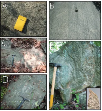
Our mapping verifies the presence of the ⬃1.5 km wide southern tail of the Ellisville pluton (Hughes, 2011). Ample outcrop exists along the Ellisville tail and it is continuous northward into the main body of the intrusion, north of 38° N latitude. The granodiorite is more resistant to weathering than the surrounding metasedimen-tary and metavolcanic rock, and thus outcrops more abundantly. The common porphyritic texture throughout the granodiorite (fig. 3A) further facilitates mapping in areas lacking direct exposure because the resultant saprolite and regolith retain a distinct coarse, rubbly texture.
The tail of the pluton is mainly medium-grained biotite granodiorite that consists primarily of quartz, plagioclase feldspar, microcline, and biotite. Commonly it is
porphyritic with feldspar crystals up to 1 cm long. Locally, near its margins, are small xenoliths of gray, fine-grained metasandstone and small areas of massive pegmatite. Granodiorite in the tail almost universally has a weak foliation; similar weak foliations elsewhere in the pluton have been identified as magmatic flow foliations (fig. 3B; Pavlides and others, 1994) as they are defined by unmodified, euhedral feldspar crystals. Granodiorite within the Ellisville main body is mineralogically uniform relative Fig. 3. The Ellisville pluton. (A) Biotite-granodiorite representative of the main phase of the pluton. Field notebook is 12 cm wide. Location in Mineral quadrangle, 38.03596 N, 77.97637 W. (B) Example of magmatic flow foliation seen in the Ellisville pluton. Compass is 7 cm wide. Location in Lahore quadrangle, 38.1405 N, 77.8895 W. (C) Intrusive contact of a dike of the finer grained c. 437 Ma phase into the medium-grained c. 444 Ma phase in the tail of the Ellisville pluton. Location in Ferncliff quadrangle, 37.96548 N, 78.03728 W. (D) Wisp-like assimilation of the medium-grained granodiorite phase into the younger finer-grained phase in the tail of the Ellisville pluton. Assimilated material directly above the hammer. Location in Ferncliff quadrangle, 37.95390 N, 78.04521 W. (E) Intrusive contact zone between the Ellisville pluton tail and surrounding Chopawamsic Formation country rock. Photo taken of a loose boulder. Similar, although less photogenic, in-place outcrop exists⬃2 meters away. Inset: A slabbed surface from the upper right portion of the boulder in figure 3E. Location in Ferncliff quadrangle, 37.9955 N, 78.0197 W.
591
to that of the Ellisville tail; however, the porphyritic texture is more developed (larger K-feldspar crystals up to 3 cm) in some places in the main body. Similar to observations made in the main body of the pluton (Pavlides and Cranford, 1982), we have also observed small areas of the younger, finer grained biotite granodiorite phase at outcrop scale that cannot be accurately resolved during mapping due to its limited distribution in addition to the lack of outcrop. This finer grained phase of biotite granodiorite appears to intrude the dominant medium-grained, commonly porphy-ritic biotite granodiorite phase of the pluton (figs. 3C and 3D).
At the present depth of exposure, the tail of the pluton lies wholly within metavolcanic and metavolcaniclastic rocks of the Chopawamsic Formation. This interpretation is based upon the direct observation of the intrusive contact of the Ellisville pluton into the Chopawamsic Formation (fig. 3E), the consistent distribution of Chopawamsic Formation rocks around the tail, and the presence of small mafic zones (Hopkins, ms, 1960) that may reflect assimilation of mafic Chopawamsic Formation country rock. Our interpretation contradicts previous depictions (Pavlides, 1989; VDMR, 1993), which show the Ellisville tail to be intrusive into rocks of both the Mine Run Complex and Chopawamsic Formation, across a tightly folded Chopawam-sic fault; this geometry of the fault may be a mapping artifact created by the compilation of regional maps that met at 38° N latitude.
Observations of: (1) continuous outcrop from the tail to the main body, (2) the intrusive relationship between the Ellisville tail and the Chopawamsic Formation (fig. 3E), (3) previous observations of the main body being intrusive into the Mine Run Complex (Pavlides and others, 1994), and (4) the presence of the Ellisville thermal aureole into both the Mine Run Complex and the Chopawamsic Formation (Pavlides, 1989; Pavlides and others, 1994), collectively support the deduction that the Ellisville pluton intruded across the terrane-bounding Chopawamsic fault. The available map-ping data indicate that the Ellisville pluton cross-cuts the Chopawamsic fault just north of 38° N latitude near or in Louisa, Virginia. Outcrop in this vicinity is sparse and no contact between the intrusive Ellisville pluton and fabrics related to the Chopawamsic fault has been discovered. The most thorough previous local mapping (Hopkins, ms, 1960) and aeromagnetic data (for example: Neuschel, 1970; VDMR, 1971; Snyder, 2005) reinforce the conclusion that the tail lies within and truncates features within the Chopawamsic Formation: the aeromagnetic signature of an iron-rich layer in the Chopawamsic formation is present to each side of the Ellisville pluton tail, but the magnetic signature is absent where the tail has been mapped and Duke (ms, 1983) also interpreted the iron-rich layer in addition to surrounding rocks of the Chopawamsic Formation to be “sharply crosscut by the Ellisville granodiorite.”
In reconnaissance mapping, we have encountered rock similar to the Ellisville tail granodiorite in the approximately 15 km between the Ferncliff quadrangle and the northern extension of the Columbia pluton mapped by Smith and others (1964) and Bailey and others (2005). In light of our collective field observations, we subscribe to the previously established mapping interpretation that the Ellisville pluton and at least some part of the Columbia pluton form a continuous body linked through the Ellisville tail (VDMR, 1963; Smith and others, 1964; Duke, ms, 1983; Spears and Bailey, 2002).
Petrography
Mineralogy throughout the pluton includes quartz, plagioclase feldspar, micro-cline, and biotite. Subordinate minerals include muscovite, zircon, and epidote, as well as rare myrmekite intergrowths. Microcline crystals range up to 3 cm long and in some places show oscillatory zonation. Petrographically, this mineral composition is homog-enous throughout the Ellisville main body and tail.
Some of the epidote in the Ellisville pluton main body has been interpreted as magmatic (rather than metamorphic) in origin (Pavlides and others, 1994). Attributes
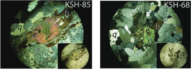
of magmatic epidote include euhedral crystals that have sharp crystal faces in contact with biotite crystals and/or contain cores of primary igneous minerals such as allanite (Zen and Hammarstrom, 1984; Schmidt and Poli, 2004). On the basis of the estab-lished criteria, we have identified examples of magmatic epidote in both the main body as well as the tail of the pluton, where it has not been previously recognized (fig. 4). Furthermore, we find magmatic epidote to exist in samples from both textural phases of the pluton. Analysis of a cored, magmatic epidote crystal in the Ellisville tail (sample KSH-85 in table 1), using an ARL-SEMQ electron microprobe yields a composition with a Pistacite (Ps) value of Ps28[Ps value calculated as: (Fe
⫹3/(Fe⫹3⫹Al))
ⴱ100],
when calculated on the basis of 13 anions. Values from magmatic epidote in the main body of the pluton (Pavlides and others, 1994) have similar values of Ps27-31 when re-calculated on the basis of 13 anions.
Among several early Paleozoic intrusions in the region, the only other plutons that reportedly display this feature are the Late Ordovician–Early Silurian Leatherwood pluton, and the Early–Middle Ordovician Lake Jackson pluton (Hibbard and others, 2013). Thus, the recognition of magmatic epidote is not common in early Paleozoic intrusive bodies and serves to provide an additional petrogenetic link between not only the tail and main body of the Ellisville pluton, but also between both textural phases of the pluton—an observation that indicates they were emplaced under similar thermody-namic and barometric conditions in the crust. These links are further supported by the nearly identical composition of the magmatic epidote, on the basis of Pistacite values, analyzed throughout the pluton. The presence of magmatic epidote, which may crystallize at 0.7 to 0.3 GPa in intermediate composition melts (Schmidt and Poli, 2004), in the Ellisville granodiorite is compatible with previous geobarometric esti-mates of 0.6 to 0.45 GPa for the intrusive body (Pavlides and others, 1994).
We have not observed magmatic epidote in petrographic analysis of the Columbia pluton, although fewer samples from this body were collected. Epidote has been noted as an accessory mineral in the Columbia pluton (for example: Smith and others, 1964; Bailey and others, 2005), but is not reported as a primary igneous mineral.
Geochemistry
Samples.—In order to support our field and petrographic interpretations that the
Ellisville main body and tail are comagmatic and constitute a single body that intruded the Chopawamsic fault, we selected nine samples from the tail and five samples from Fig. 4. Examples of magmatic epidote in the Ellisville pluton. Sample numbers correspond to samples and locations listed in table 1. Sample KSH-85 is from the tail of the pluton. Sample KSH-68 is from the main body of the pluton. Each large figure is in cross polarized light and includes an inset figure of the same location in plane light. Diameter of field of view in each photo measures⬃2.5 mm. Abbreviations are b⫽ biotite, e⫽epidote, f⫽feldspar, and q⫽quartz.
593
Table1
XRF major oxide data and locations of geochemical samples
Sample Pluton/Area Quad Lat Lon SiO2 Al2O3 Fe2O3T MgO CaO Na2O K2O TiO2 P2O5 MnO LOI
KSH-18 Ellivsille Tail Ferncliff 37.97844 -78.02503 61.44 17.00 3.96 3.20 4.01 3.56 2.85 0.48 0.18 0.06 1.04 KSH-47 Ellivsille Tail Ferncliff 37.94540 -78.05957 57.23 16.16 4.99 3.37 5.24 3.31 1.73 0.64 0.23 0.07 0.76 KSH-66 Ellivsille Tail Ferncliff 37.98951 -78.01913 69.04 18.56 3.33 2.66 3.89 4.16 2.26 0.46 0.07 0.04 0.73 KSH-68 Ellisville Main Body Mineral 38.07267 -77.92471 65.24 15.96 2.88 1.41 3.06 3.18 3.52 0.37 0.12 0.05 0.44 KSH-85 Ellivsille Tail Ferncliff 37.97021 -78.03252 58.16 17.27 3.76 2.66 3.16 3.50 3.02 0.45 0.16 0.05 1.10 KSH-86 Ellivsille Tail Ferncliff 37.96328 -78.02464 70.09 17.52 3.10 2.07 3.71 4.03 2.85 0.38 0.15 0.05 0.85 KSH-94 Ellivsille Tail Ferncliff 37.96671 -78.04382 56.57 17.82 5.16 3.95 4.15 3.24 3.02 0.59 0.20 0.07 1.28 KSH-96 Ellisville Main Body Louisa 38.08479 -78.00499 65.09 16.48 2.96 1.66 3.46 3.30 3.42 0.42 0.17 0.05 0.64 KSH-102 Columbia Palmyra 37.75769 -78.25643 60.56 16.45 3.67 2.18 3.85 3.59 2.76 0.44 0.16 0.06 1.14 KSH-103 Ellisville Main Body Mineral 38.09769 -77.97620 71.40 16.76 1.98 1.01 2.64 3.47 3.69 0.28 0.10 0.04 0.71 KSH-104 Ellisville Main Body Mineral 38.06391 -77.97611 60.52 16.68 3.09 1.53 2.87 2.99 3.16 0.45 0.20 0.05 1.25 KSH-105 Ellisville Main Body Mineral 38.00970 -77.99222 57.49 13.59 3.86 2.55 3.31 2.74 3.20 0.44 0.16 0.06 0.51
KSH-115 Ellisville Tail Ferncliff 37.94918 -78.06857 - - - - - - - 0.62
KSH-116 Columbia Columbia 37.86904 -78.18857 63.09 17.07 4.08 2.81 1.35 3.73 3.29 0.45 0.13 0.06 1.80 KSH-117 Columbia Columbia 37.80935 -78.20415 53.00 17.34 4.25 2.38 4.26 2.79 2.65 0.53 0.17 0.08 4.44 KSH-126 Columbia Columbia 37.82180 -78.24885 61.31 16.34 3.62 2.57 3.00 3.01 3.93 0.44 0.14 0.07 1.10 KSH-127 Ellisville Tail Ferncliff 37.95590 -78.05381 65.07 17.54 1.96 0.71 2.08 4.15 3.92 0.23 0.08 0.03 0.73 KSH-128 Ellisville Tail Ferncliff 37.90317 -78.12001 62.02 16.35 4.12 3.22 4.14 3.21 3.78 0.53 0.16 0.07 0.82
594
K.
S.
Hughes
and
others—Relationship
between
the
Ellisville
Table2
XRF data of trace elements in ppm
Sample S Cl Sc V Cr Ni Cu Zn Ga As Rb Sr Y Zr Nb Ba Ce Pb Th U KSH-18 249.45 400.50 <LD 71.68 32.88 9.94 7.45 13.14 17.61 15.64 76.86 546.87 6.82 132.17 10.58 1126.29 93.59 18.97 9.92 <LD KSH-47 141.62 196.87 10.06 103.31 28.65 13.40 9.38 16.36 18.01 <LD 65.76 600.99 10.89 164.67 12.65 757.35 68.44 13.69 <LD <LD KSH-66 131.63 267.82 12.54 71.29 24.00 5.58 13.80 3.95 18.89 <LD 63.90 503.18 4.95 174.17 9.97 516.82 <LD 19.23 6.29 <LD KSH-68 198.13 97.78 <LD 40.31 6.88 <LD 10.98 10.28 17.50 <LD 105.10 358.38 3.86 191.51 10.83 1097.21 127.92 20.19 15.69 4.99 KSH-85 146.41 264.97 <LD 70.07 28.31 6.94 <LD 11.90 16.99 <LD 72.39 573.64 6.49 120.04 9.58 1405.78 93.04 11.03 8.95 <LD KSH-86 133.82 154.40 9.36 61.14 20.47 8.09 <LD <LD 17.63 16.74 87.97 458.02 10.77 122.10 15.19 812.44 68.83 15.74 12.00 <LD KSH-94 178.98 297.12 <LD 96.96 45.11 13.36 12.68 21.32 21.23 <LD 92.75 536.71 7.48 157.13 10.81 899.72 118.70 17.00 9.00 <LD KSH-96 125.89 75.43 7.86 51.86 19.34 <LD 7.59 4.51 17.05 <LD 102.76 453.22 8.10 139.91 13.57 944.30 101.09 22.32 13.68 <LD KSH-102 133.82 90.17 <LD 66.81 37.35 8.40 5.42 5.65 16.83 <LD 86.40 455.53 9.29 126.35 13.61 1005.42 <LD 16.69 11.17 <LD KSH-103 128.08 67.15 <LD 36.26 10.77 <LD 32.39 <LD 16.29 19.20 115.40 352.11 4.54 111.19 13.27 576.26 <LD 26.25 11.88 5.37 KSH-104 177.20 99.63 <LD 52.55 43.46 <LD 8.17 9.56 18.46 <LD 104.34 403.98 5.40 155.48 13.12 932.14 134.06 20.92 17.30 <LD KSH-105 268.46 99.67 <LD 61.22 33.52 10.27 9.72 11.11 16.63 <LD 96.19 504.13 6.11 162.74 10.80 992.87 124.39 19.09 11.78 <LD KSH-115 133.69 108.68 <LD 19.02 9.65 <LD <LD 3.29 21.74 <LD 155.15 221.51 8.82 125.04 17.21 680.29 81.09 26.97 11.36 <LD KSH-116 129.72 57.97 11.47 70.21 34.66 9.06 16.85 11.92 17.76 <LD 73.95 247.17 7.77 113.64 12.82 923.17 62.57 7.02 8.97 <LD KSH-117 339.21 81.67 14.50 88.30 22.30 9.66 <LD 13.62 17.52 <LD 88.53 258.86 14.31 134.41 18.39 828.89 46.53 16.86 12.80 <LD KSH-126 119.87 30.09 <LD 56.09 32.64 10.49 5.98 10.50 15.87 <LD 107.84 428.32 9.16 107.52 14.87 999.28 87.01 23.21 13.39 4.73 KSH-127 138.47 47.74 <LD 26.05 <LD <LD <LD 6.63 19.79 <LD 154.73 239.06 9.26 123.89 15.31 758.13 69.46 27.37 13.79 6.84 KSH-128 139.70 247.24 <LD 79.25 40.95 9.27 <LD 7.31 19.09 <LD 92.77 442.68 8.83 109.02 13.63 801.03 96.92 19.10 11.06 <LD Detection
Limit (LD)
17.45 33.25 8.18 6.47 7.32 4.34 4.09 2.19 3.43 15.14 0.83 1.40 0.74 1.35 0.84 22.14 42.09 4.56 3.74 4.35
595
establishment
of
significant
Late
Ordovician
faulting
in
the
Appalachian
the main body for geochemical analyses. These samples collected are mostly from the main, medium-grained phase of the pluton. We also collected four samples from the northwestern phase of the nearby Columbia composite pluton to compare with the data from the Ellisville pluton. Samples with xenoliths were avoided and no unusual mineral assemblages or compositions were found in hand specimen or in thin section analysis. Geochemical analytical techniques are outlined in Appendix 1 and the results are shown in tables 1, 2 and 3.
Results.—Chemical alteration and element mobility over geologic time can hinder
attempts at interpreting geochemical data. Because the Ellisville pluton is an early Paleozoic body and situated near areas of known mineralization within the Chopawam-sic terrane (for example: Good and others, 1977; Gair, 1978; Sweet, 1980; Pavlides and others, 1982a; Duke, ms, 1983; Spears and Upchurch, 1997), several efforts have been made to assess the degree of geochemical alteration within our samples. After normalizing major oxide concentrations to an anhydrous 100 percent, all samples contain 60 to 70 percent SiO2, indicating that only minimal, if any, hydrothermal silica loss or gain has occurred in these rocks of granodiorite composition. Our entire sample set falls within the igneous spectrum of Hughes (1973), suggesting that regional metamorphism has not affected the bulk concentrations of the easily mobi-lized elements of Na and K (fig. 5A). Furthermore, in all of our samples, Na2O shows no significant sign of loss or alteration when compared to Al2O3(fig. 5A). The results from these measures of alteration indicate that the geochemical data can be used and interpreted as the original igneous composition for each sample.
The rocks of the Ellisville pluton can be chemically classified as calc-alkaline using both the A-F-M ternary diagram of Irvine and Baragar (1971) and the SiO2vs K2O plot of Pecerillo and Taylor (1976) (fig. 5B). These rocks also mostly plot within the granodiorite field of both the Ab-An-Or (after Barker, 1979) and Q-A-P (after Streck-eisen, 1974) ternary diagrams (fig. 5B). All samples plot in the I-type magma field of Chappell and White’s (1974, 2001) Na2O vs SiO2diagram (fig. 5B).
Primitive mantle-normalized (Sun and McDonough, 1989) trace element compo-sitions are similar across all analyzed samples (fig. 5C). All eighteen of our samples show consistent patterns with prominent Nb anomalies, commonly interpreted to indicate a subduction-related origin (for example: Pearce, 1982; Baier and others, 2008). Trace element discrimination diagrams of Yb vs Ta and Y⫹Nb vs Rb (Pearce and others, 1984) suggest that the samples analyzed are representative of syn-collisional to volcanic-arc type granitoids (fig. 5C).
Chondrite-normalized (Sun and McDonough, 1989) REE data show enrichment in the light REE and relative depletion in the heavy REE (fig. 5C). As with major oxides and trace elements, the REE signatures are quite similar for all Ellisville pluton samples analyzed and display no systematic or obvious variations. Furthermore, our results correlate well with REE data obtained by Pavlides and others (1994) for the main body of the pluton.
The composition of all samples from the Ellisville pluton analyzed suggests it was emplaced as a result of subduction-related arc magmatism. This data is consistent with previous interpretations of the tectonic setting during the timing of Ellisville intrusion and support the model that the Ellisville pluton was emplaced when the oceanic crust outboard of the Chopawamsic arc subducted westward (modern geographic orienta-tion) beneath the modified Laurentian margin. The geochemical similarities through-out the Ellisville pluton indicate that the geochemical composition of granodiorite is consistent throughout the two major textural phases observed in the pluton. Most important to this study, the geochemical correlation of granodiorite throughout the Ellisville pluton on each side of the Chopawamsic fault supports the deduction that the
Table3
ICPMS data for trace and rare earth elements in ppm
Sample Y Zr Nb Ba La Ce Pr Nd Sm Eu Gd(160) Tb Dy Ho Er Tm Yb Lu Hf Ta Th
KSH-18 7.24 192.16 7.94 1140.65 38.57 62.14 7.21 24.93 3.61 0.90 1.99 0.29 1.52 0.28 0.74 0.11 0.58 0.09 4.11 1.19 11.12 KSH-47 10.79 184.40 10.13 677.87 26.52 54.54 6.16 22.71 3.79 1.03 2.58 0.41 2.23 0.42 1.18 0.17 1.10 0.16 3.48 1.21 6.74 KSH-66 4.65 162.44 6.98 456.13 11.58 22.69 2.40 8.42 1.43 0.64 0.96 0.16 0.95 0.18 0.56 0.08 0.45 0.09 3.46 1.06 5.25 KSH-68 3.81 189.63 8.03 1086.68 47.42 82.42 8.38 28.08 3.84 0.76 1.58 0.20 0.94 0.16 0.41 0.06 0.48 0.07 3.95 1.00 14.30 KSH-85 7.58 174.87 8.51 1155.57 25.41 54.56 5.50 19.20 3.38 0.89 2.21 0.34 1.73 0.31 0.76 0.10 0.66 0.09 3.79 1.09 8.44 KSH-86 10.73 174.21 11.15 964.15 30.67 53.23 6.23 21.50 3.26 0.45 2.14 0.34 2.04 0.41 1.11 0.16 1.10 0.17 3.96 2.52 12.93 KSH-94 8.60 185.81 10.28 775.88 33.92 58.63 7.03 24.30 3.76 0.95 2.31 0.35 1.99 0.33 0.92 0.12 0.82 0.10 3.97 0.88 12.81 KSH-96 8.02 144.37 10.07 966.37 24.33 60.39 5.42 18.78 3.22 0.78 1.98 0.34 1.82 0.32 0.78 0.12 0.80 0.12 3.25 1.27 11.71 KSH-102 9.79 139.27 11.53 1056.55 25.17 38.80 5.53 19.45 2.97 0.81 2.03 0.32 1.85 0.39 1.08 0.17 1.07 0.15 3.08 1.39 15.38 KSH-103 4.54 151.32 9.21 674.75 13.92 31.22 3.28 11.69 2.05 0.55 1.14 0.18 1.07 0.20 0.52 0.09 0.61 0.09 3.73 1.79 10.00 KSH-104 5.20 197.94 9.26 1024.25 29.28 63.56 6.37 21.74 3.43 0.84 1.51 0.24 1.32 0.22 0.58 0.08 0.60 0.08 4.45 1.03 15.50 KSH-105 7.09 215.70 9.41 1103.98 37.79 67.08 7.20 24.29 3.68 0.85 1.78 0.30 1.54 0.27 0.71 0.11 0.75 0.09 4.61 1.11 13.08 KSH-115 9.70 149.25 13.73 691.51 37.48 65.75 7.02 23.51 3.74 0.73 2.06 0.40 2.05 0.34 0.91 0.14 0.89 0.13 3.71 1.87 18.09 KSH-116 7.57 117.74 9.54 795.94 31.55 50.47 5.72 19.80 3.01 0.67 1.59 0.28 1.57 0.27 0.81 0.11 0.81 0.11 2.78 1.20 10.60 KSH-117 14.27 184.51 15.77 830.35 31.64 61.45 6.94 25.58 4.39 1.00 2.89 0.47 3.03 0.57 1.72 0.24 1.50 0.23 4.21 1.25 13.40 KSH-126 12.65 159.95 14.70 913.06 31.84 56.39 6.73 24.59 4.14 0.89 2.65 0.41 2.35 0.44 1.36 0.21 1.45 0.19 3.97 1.42 18.34 KSH-127 8.62 131.66 11.02 844.74 15.51 37.26 3.03 10.56 2.02 0.56 1.44 0.25 1.60 0.33 0.88 0.15 1.06 0.13 3.32 1.55 12.25 KSH-128 8.67 152.01 10.05 863.55 29.31 58.75 5.95 21.02 3.38 0.80 1.99 0.33 1.90 0.33 0.97 0.15 0.99 0.14 3.60 1.64 12.35 Detection
Limit
0.051 0.299 0.221 1.368 0.061 0.055 0.045 0.778 0.371 0.136 0.150 0.059 0.165 0.044 0.264 0.048 0.293 0.029 0.402 0.345 0.041
597
establishment
of
significant
Late
Ordovician
faulting
in
the
Appalachian
Igneous
Ellisville main body Ellisville tail Columbia pluton
Solid symbols represent our data. Hollow symbols represent data from previous work (Pavlides et al, 1994; Wilson, 2001).
n=18 n=10 n=7
Fig. 5. Geochemical diagrams. Explanation shown at bottom-right of figure. (A) Tests for element mobility. All data plot inside of the Igneous Spectrum of Hughes (1973). When comparing Na2O to
Al2O3/Na2O, no analyzed samples show indications of sodium loss or alteration. (B) Major oxide
geochem-istry. Q-A-P (Streckeisen, 1974) and Ab-An-Or (Barker, 1979) ternary diagrams show the majority of samples plot in the granodiorite field. A-F-M (K2O⫹Na2O⫺FeO⫹Fe2O3⫺MgO) (Irvine and Baragar, 1971) and
SiO2vs K2O (Pecerillo and Taylor, 1976) diagrams show that the samples analyzed are calc-alkaline in
nature. All samples also plot in the I-type field of the K2O vs Na2O diagram of Chappell and White (1974).
(C) Rare earth and trace element plots. When normalized to primitive mantle values of Sun and McDonough (1989), trace element data show similar patterns for all samples analyzed. Also, rare earth element data display consistent arrays when normalized to chondrite values (Sun and McDonough, 1989). The gray field in the rare earth element plot represents data from the Ellisville pluton determined by Pavlides and others (1994). Trace element discrimination diagrams of Pearce and others (1984) indicate that the Ellisville pluton has a volcanic-arc to syn-collisional signature.
pluton stitches the Chopawamsic fault and can be used as a reliable timing constraint for latest motion upon the structure.
Geochronology
Samples.—In order to constrain the timing of motion on the Chopawamsic fault,
we dated two samples of the cross-cutting Ellisville pluton by U-Pb thermal ionization mass spectrometry (TIMS). We wrestled a sample from the previously undated tail of the pluton (sample KSH-86 in table 1) from an outcrop along the South Anna River in southern Louisa County; this rock represents the medium-grained, commonly porphy-ritic biotite granodiorite main phase of magmatism. We sampled the main body of the pluton (sample KSH-68 in table 1) from the same quarry in Louisa County that previously yielded samples with calculated ages of 444 ⫾6 Ma (U-Pb zircon, Wilson, ms, 2001), 438 ⫾ 10 Ma (Pb-Pb multiple zircon populations, Pavlides and others, 1994), and 441⫾8 Ma (Rb-Sr whole rock, Pavlides and others, 1982b); our sample was taken from the subsidiary fine-grained biotite granodiorite phase of the pluton. Re-sampling the main body of the pluton allows us to compare ages throughout the pluton and by dating two new samples simultaneously, we effectively minimize inter-laboratory and methodological biases that may mask the resolution of any, potentially small, age difference between any two areas or textural phases within the pluton. We took care to avoid any xenoliths and found no unusual or heterogeneous compositions of our samples in hand sample or thin section. Geochronological analytical techniques are outlined in Appendix 2. All errors are both plotted on diagrams and reported in tables at the 2confidence level.
Results.—Seven fractions from medium-grained sample KSH-86, consisting of five
single zircon grains and two pairs of grains, yield an upper intercept age of 443.7⫾4.4 Ma with a mean square of weighted deviates (MSWD) value of 2.1 (fig. 6). One relatively imprecise analysis with a large proportion of common Pb fell off the regression line, likely due to slight inaccuracies in the common Pb correction (dashed in fig. 6). Seven fractions, consisting of six single zircon grains and one pair of two small zircon grains were analyzed from fine-grained sample KSH-68 and yield an upper-intercept zircon age of 436.8 ⫾ 4.2 Ma with MSWD ⫽ 1.08 (fig. 6). One single-grain analysis yielded a nearly concordant age of 1090 Ma and is interpreted to indicate the presence of Mesoproterozoic inheritance or melt source contribution to the magma. All values from TIMS analyses are reported in table 4. Photographs of all zircons dissolved and analyzed are shown in figure 6. The lower intercept value for each regression was within error of the origin.
We interpret the upper intercept ages to reflect the times of crystallization of magmatic zircons from each sample. Our data are consistent with previously deter-mined ages for the Ellisville pluton (Pavlides and others, 1994; Wilson, ms, 2001; Sinha and others, 2012) as well as a regionally extensive suite of Late Ordovician to Early Silurian magmatism recorded in the western Piedmont of Virginia (for example: Wilson, ms, 2001; Aleinikoff and others, 2002; Horton and others, 2010; Sinha and others, 2012; Hibbard and others, 2013). However, our analyses were conducted by the same analytical methods, in the same laboratory, under the same operating conditions; they therefore provide a consistent basis for comparison of the two phases of granodio-rite present in the Ellisville pluton. Furthermore, the above stated age-errors include uncertainties in the U decay constant, which must be considered when comparing with other geochronologic methods, but cancel out when comparing U-Pb ages. By excluding U decay constants as a source of uncertainty, age-errors are reduced to 436.8⫾1.9 Ma (fine-grained phase, KSH-68) and 443.7⫾3.3 Ma (medium-grained phase, KSH-86), rendering resolvable the age difference of the two samples. These data support field observations, which indicate that the fine-grained phase of the pluton represents a younger portion of the intrusive body. In light of these new 599
geochronological data, field observations, geochemical data, and previous work (Pav-lides and Cranford, 1982; Pav(Pav-lides and others, 1994; Wilson, ms, 2001) we interpret the Ellisville pluton to consist of two mineralogically and chemically indistinguishable, yet texturally distinct pulses of magma (potentially created by dissimilar cooling rates), which were emplaced atca.444 Ma andca.437 Ma.
Theca.444 Ma age represents the best estimate for the crystallization age of the Ellisville pluton as a whole because it is the most volumetrically significant phase Fig. 6. Geochronology of the Ellisville pluton. A fine-grained granodiorite sample (light gray ellipses— sample KSH-68) from the main body of the pluton yields an upper intercept zircon age of 437⫾4 Ma. Errors include Uranium decay constant errors (shown as the band along the concordia curve). A medium-grained granodiorite sample (dark gray ellipses—sample KSH-86) from the tail of the pluton yields an upper intercept zircon age of 444 ⫾ 4 Ma. Error ellipses are displayed at the 2-sigma confidence interval. Photographs show images of zircons dissolved and analyzed. (A and B) are from sample KSH-68. (C and D) are from sample KSH-86. The “Z” numbers correspond to analyses listed in table 4. One of the zircons in fraction Z12 was lost during sample preparation; therefore the data for this sample only reflect the dissolution of one of the crystals shown in the photograph.
Table4
Geochronological data for the Ellisville pluton
Compositional Parameters Radiogenic Isotope Ratios Isotopic Ages
Sample Mass
Ellisville Pluton "body" (KSH68), N38.07267, W77.92470
(a) (b) (c) (c) (d) (e) (e) (e) (e) (f) (g) (g) (h) (g) (h) (g) (h) (i) (h) (i) (h) (i) (h) (Z37) medium equant (1) (0.003 0.98 72.0 0.520 2.8364 99.69% 101 0.71 6061 0.164 0.055661 0.139 0.535152 0.203 0.069731 0.127 0.738 438.87 3.09 435.22 0.72 434.53 0.53 (Z38) large prism (1) 0.003 0.61 116.1 0.377 4.6849 99.71% 104 1.11 6406 0.114 0.075649 0.150 1.920183 0.221 0.184094 0.132 0.751 1085.79 3.01 1088.13 1.48 1089.30 1.32
Ellisville Pluton "tail" (KSH86), N37.96328, W78.02464
(Z5) very large prism (1) 0.014 11.67 883.5 0.598 34.3512 99.93% 475 1.86 27947 0.188 0.055857 0.049 0.543757 0.169 0.070603 0.148 0.961 446.69 1.09 440.90 0.60 439.79 0.63 (Z6) very large rhomb (1) 0.013 9.11 679.3 0.555 26.6382 99.85% 211 3.20 12593 0.174 0.055678 0.322 0.538345 0.367 0.070125 0.194 0.481 439.56 7.17 437.33 1.30 436.91 0.82
0.003 5.80 435.1 0.573 16.9879 99.87% 234 1.86 13837 0.180 0.055778 0.216 0.539786 0.250 0.070187 0.125 0.508 443.55 4.79 438.28 0.89 437.28 0.53
(Z39) acicular prism (1) 0.003 1.11 85.1 0.622 3.2706 99.77% 138 0.61 8084 0.196 0.055842 0.110 0.544642 0.150 0.070737 0.073 0.719 446.10 2.45 441.48 0.54 440.59 0.31 (Z40) equant prism (1) 0.004 2.46 188.2 0.629 7.2430 99.85% 209 0.90 12203 0.198 0.055791 0.074 0.543746 0.124 0.070686 0.073 0.838 444.05 1.65 440.89 0.44 440.29 0.31 (Z41) acicular prism (1) 0.004 1.66 131.2 0.739 4.8857 99.68% 101 1.29 5753 0.232 0.055789 0.162 0.543569 0.196 0.070665 0.087 0.582 443.97 3.60 440.78 0.70 440.16 0.37
(a) Zircon fraction description and label, number of grains in parentheses; all fractions annealed and chemically abraded after Mattinson (2005). (b) Zircon mass estimated from photomicrograph grain dimensions prior to chemical abrasion.
(c) Elemental mass of U and total Pb after chemical abrasion; concentrations not given due to unknown proportion of sample mass loss during chemical abrasion.
(d) Model Th/U ratio calculated from radiogenic208Pb/206Pb ratio and207Pb/235U age.
(e) Pb* and Pbc represent radiogenic and common Pb, respectively; mol %206Pb* with respect to radiogenic, blank and initial common Pb.
(f) Measured ratio corrected for spike and fractionation only. All Pb analyses were by secondary electron multiplier using mass bias of 0.18%/AMU based on repeat analyses of NBS-981.
(g) Corrected for fractionation, spike, and common Pb; all Pb was assumed to be procedural blank:206Pb/204Pb⫽18.66⫾0.8%;207Pb/204Pb⫽15.55⫾0.3%;
208Pb/204Pb⫽37.62⫾0.7%.
(h) Errors are 2-sigma, propagated using the algorithms of Schmitz and Schoene (2007) and Crowley and others (2007).
(i) Calculations are based on the decay constants of Jaffey and others (1971) and238U/235U⫽137.88.
throughout the pluton. Pavlides and others (1994) found40Ar/39Ar ages of amphi-boles within the surrounding Mine Run Complex to have cooling ages of 435⫾ 2, 437⫾2, and 438⫾2 Ma, which were interpreted to be reset due to the intrusion of the Ellisville pluton. These data appear to reflect cooling after a culminating thermal imprint upon the surrounding country rock, and indicate that there has been no significant thermal event to affect the rocks in the vicinity of the Ellisville pluton after theca.444 Ma andca.437 Ma emplacement of the Ellisville biotite granodiorite.
chopawamsic fault: mapping and kinematics
In the vicinity of the Ellisville pluton, distinct differences in rock type, magnetic character, and structural features between rocks of the Potomac and Chopawamsic terranes allow for the delineation of the surface trace of the Chopawamsic fault (Duke, ms, 1983; Pavlides, 1989; Pavlides and others, 1994; Mixon and others, 2000; Hughes, 2011).
The Mine Run Complex consists of phyllite and interbedded metasandstone lenses with very little variation outside of a few areas interpreted to be exotic blocks within the metaclastic assemblage. In contrast, Chopawamsic Formation rocks are more compositionally variable and include local areas of interlayered dark, biotite-chlorite schists on the order of 1 cm to 1 m thick (fig. 7A)—a feature previously interpreted to be the remnants of fine-grained volcanic and/or re-worked volcanic mafic to intermediate strata within the greater Chopawamsic pile (Pavlides and others, 1994). In this area, such strata are unique to the Chopawamsic Formation and do not exist in any units of the Mine Run Complex.
Metaclastic rocks of Mine Run Complex unit III, which borders the Chopawamsic fault in our study area (fig. 2), contain abundant magnetite, a defining characteristic of that unit (Pavlides, 1989). This abundance contributes to one of the most pronounced aeromagnetic anomalies in the Virginia Piedmont (for example: Neuschel, 1970; VDMR, 1971; Zietz and others, 1977; Snyder, 2005) and has been referred to as the Shores magnetic lineament (Brown, 1986). Chopawamsic Formation rocks, which exist to the east of the Chopawamsic fault, typically contain far less magnetite.
There also exists a structural discontinuity along the trace of the Chopawamsic fault. Rocks of the Mine Run Complex to the west of the Chopawamsic fault locally display two foliations (fig. 7B) and they are also commonly isoclinally folded at outcrop and microstructural scale (figs. 7B, 7C, and 7D). These folds are interpreted to be related to map-scale folds in the Mine Run Complex that pre-date development of the Chopawamsic fault (Hughes, 2010; Hughes, 2011). Rocks of the Chopawamsic Forma-tion in this area have only one foliaForma-tion, which is commonly parallel to composiForma-tional layering, and lack common outcrop scale folding (fig. 7A).
Although these aforementioned compositional and structural differences alone do not require the presence of a fault between the Potomac and Chopawamsic terranes, strong evidence of the Chopawamsic fault in the vicinity of the Ellisville pluton tail exists in the seismic line along Interstate Highway 64 (Harris and others, 1982, 1986; Pratt and others, 1988). This reflection profile shows the Chopawamsic fault as one of many thrust faults across the Virginia Blue Ridge and Piedmont. Contrasting suites of detrital zircon data from the terranes astride the fault also support and highlight the significance of the Chopawamsic fault (Hughes and others, 2012a).
Until now, the Chopawamsic fault has not been validated by kinematic investiga-tion other than the meninvestiga-tion of strongly sheared rocks in the Chopawamsic Formainvestiga-tion at the James River (Brown, 1979) and an inexplicit reference to steeply dipping mylonite along the fault (Pavlides, 1989, 2000). In the vicinity of the Ellisville pluton, the search for fault-related kinematic indicators is hampered by a deficiency in bedrock outcrop and generally fine-grained mineral assemblages in rocks on each side
of the fault. Recognizing mylonite zones requires an observance of dynamic grain size reduction from equivalent rocks outside of a shear zone. Thus, rocks that are fine-grained in their undeformed state will be macroscopically difficult to segregate from those that have been sheared. Considering these limitations, the amount of data Fig. 7. Features that help delineate the Chopawamsic fault. (A) Compositional layering observed in Chopawamsic Formation. For scale, the thickest mafic bed is⬃1 m thick. Location in Ferncliff quadrangle, 37.94007 N, 78.00709 W. (B) Scanned image of a thin section from unit III of the Mine Run Complex. A folded quartz vein (dashed line) that is parallel to an early foliation is cut by a second foliation (dotted line). Inset shows same image without drawn lines. For scale, the thin section is 4.5 cm long. Location in Ferncliff quadrangle, 37.98818 N, 78.08003 W. (C and D) Typical outcrop scale folding seen in rocks of the Mine Run Complex. Such folding in the study area is restricted to only the Mine Run Complex and is interpreted to pre-date the Chopawamsic fault. Locations in Ferncliff quadrangle at 37.98286 N, 78.09202 W and 37.98711 N, 78.09213 W. (E and F) Sinistral shear preserved on sigma-type winged feldspar clasts in the Chopawamsic Formation near the Chopawamsic fault. Polycrystalline feature in the lower portion of E is a lenticular quartz clast, not a vein. Photos are looking down dip of foliation with S⫽218°, D⫽75°NW. For scale, long axis of clast in E measures 2.1 mm; long axis of clast in F measures 1.25 mm. Location in Ferncliff quadrangle, 37.97766 N, 78.06585 W.
603
collected in this area is sparse, but must be considered. We have discovered kinematic confirmation that supplements the existing body of evidence that has identified the Potomac-Chopawamsic terrane boundary as a major early Paleozoic fault. We observe some rocks of the Chopawamsic Formation along the trace of the Chopawamsic fault retain steep, down dip clast and mineral lineations which are consistent with the inferred thrust component along the fault (for example: Harris and others, 1982; Duke, ms, 1983; Harris and others, 1986; Pavlides, 1989; Horton and others, 1989; Pavlides, 1990; Horton and others, 1991; Pavlides and others, 1994; Pavlides, 1995; Mixon and others, 2000; and Mixon and others, 2005). In addition to these linear indicators, some epiclastic rocks of the Chopawamsic Formation near the unexposed trace of the fault exhibit sigma-type winged feldspar porphyroclasts on sub-horizontal surfaces that indicate sinistral shear in map view (figs. 7E and 7F).
The co-existence of sub-horizontal shear sense indicators along with complemen-tary vertical stretching lineations has been observed in other geologic settings and interpreted to have formed in a transpressional deformational setting (for example: Hudleston and others, 1988; Tikoff and Greene, 1997; Williams and Vernon, 2001). From the existing body of evidence, we propose that the Chopawamsic fault is a manifestation of a probable transpressional system resulting from sinistral conver-gence along the Potomac-Chopawamsic terrane boundary. We have observed similar kinematic indicators along strike to the north in the vicinity of the Rappahannock River (Hughes and others, 2012b), and to the south at the James River, but these are beyond the extent of the current study.
discussion
This study was undertaken to assess the previously depicted, yet unsubstantiated interpretation of a stitching relationship between the Ellisville pluton and Chopawam-sic fault that was largely predicated on simple, anecdotal regional supposition. Our results, based on detailed mapping, petrography, geochemistry, and geochronology confirm that the pluton stitches the Potomac and Chopawamsic terranes across the Chopawamsic fault. Documentation of this relationship is critical in order to under-stand the tectonic history of the region.
Considering all data, the Ellisville biotite granodiorite main body and tail repre-sent a coherent, magmatic epidote-bearing, calc-alkaline pluton that intruded the Potomac and Chopawamsic terranes in a main pulse atca.444 Ma, effectively stitching rocks across the Chopawamsic fault, which formed as the Chopawamsic terrane was accreted to Laurentia. This interpretation is further supported by both earlier regional mapping (Hopkins, ms, 1960; Pavlides and Cranford, 1982; Duke, ms, 1983) and the report that a thermal aureole around the main body of the Ellisville pluton overprints rocks on each side of the Chopawamsic fault (Pavlides and others, 1994).
Crystallization ages for the main phase of the pluton provide a date ofca.444 Ma for latest movement on the Chopawamsic fault. Amphibole cooling ages from olisto-liths in the surrounding Mine Run Complex range from 438 to 435 Ma (Pavlides and others, 1994) and show that these rocks near the Chopawamsic fault have experienced no significant regional metamorphism after the terminal phase of Ellisville magmatism atca.437 Ma.
Recognition of the Chopawamsic fault as latest Ordovician or older is important in order to distinguish it from thrust faults in the region that are either associated with the late Paleozoic amalgamation of Pangea or reactivated as Mesozoic listric normal faults (for example: Spears and Bailey, 2002; Bailey and others, 2004; Spears and others, 2004; Spears, 2010; Spears and Gilmer, 2012). On the basis of the timing constraint provided by the Ellisville pluton, we interpret nearby kinematic indicators along the Chopawamsic fault to be representative of motion along the fault prior toca.
444 Ma. Earliest motion along the Chopawamsic fault is constrained by theca.453 Ma
volcanic age from the hanging wall Chopawamsic Formation (Horton and others, 2010). We interpret this 453 Ma age to be representative of the youngest volcanism for the entire Chopawamsic Formation, a cohesive fragment of volcanogenic crust that appears to record volcanism fromca.471 to 453 Ma. In light of these relationships and our kinematic observations, we interpret the Chopawamsic fault to be a sinistral thrust fault with motion limited to some period in the Late Ordovician, betweenca.453 to 444 Ma.
The relationship of the Ellisville pluton to the Columbia composite pluton remains uncertain. The coincidence of rock type and crystallization ages for the Ellisville main body (444 Ma; Wilson, ms, 2001), Ellisville tail (444 Ma; this study), and northwest phase of the Columbia pluton (444 Ma; Sinha and others, 2012) suggest that part of the Columbia pluton may represent magmatism related to the Ellisville pluton rather than the eastern Columbia phase, dated atca.457/459 Ma (Wilson, ms, 2001; Sinha and others, 2012). Our reconnaissance mapping, geochemical analyses, and previous geologic maps (Hopkins, ms, 1960; Smith and others, 1964; Duke, ms, 1983; Bailey and others, 2005) suggest that both plutonic bodies are linked via the Ellisville pluton tail. Limited geochemical data from the northwestern porphyritic granodiorite phase of the Columbia pluton suggest that it is indistinguishable from the Ellisville pluton—the relationship between the Ellisville and Columbia plutons seems likely, but verification of this connection warrants further investigation.
Timing along the Chopawamsic fault does not directly address the issue of provenance for the Chopawamsic arc. The origin of this volcanogenic fragment of crust remains suspect, but the conclusions presented here are important to understand-ing the timunderstand-ing of tectonic development durunderstand-ing the time of Chopawamsic accretion. Future work will be targeted on identifying the source craton for the Chopawamsic arc. With the present dataset, the Chopawamsic fault remains a viable candidate for the main Iapetan suture but also remains equally viable as a structure that telescoped a peri-Laurentian arc system in the Late Ordovician.
Our new timing constraints and kinematic observations along the Chopawamsic fault allow for its comparison with other regional structures. The Chopawamsic fault is temporally and kinematically similar to the Gold Hill shear zone (GHSZ) of central North Carolina (Hibbard and others, 2012b) as they both record Late Ordovician sinistral transpression; however, the Chopawamsic fault borders the Laurentian Po-tomac terrane, while the GHSZ is internal to the peri-Gondwanan crustal block of Carolinia (Hibbard and others, 2012a). The GHSZ has been interpreted to represent the kinematics of the Cherokee orogeny—the event responsible for the Late Ordovi-cian–Early Silurian accretion of Carolinia to Laurentia (Hibbard, 2000; Hibbard and others, 2007; Hibbard and others, 2010). Consequently, we suggest that, regardless of the crustal affinity of the Chopawamsic terrane, development of the Chopawamsic fault is also a manifestation of this event. Temporal and kinematic correlation of these structures is significant because it indicates that Laurentia and Carolinia were both undergoing sinistral shortening during the Cherokee orogeny, thus tectonically link-ing the Laurentian (Chopawamsic fault) and peri-Gondwanan (GHSZ) realms in the Late Ordovician.
summary
Field mapping, petrography, geochemical analyses, and geochronological analy-ses indicate that the Ellisville granodiorite, composed of 2 phaanaly-ses of biotite granodio-rite, intruded both the Potomac and Chopawamsic terranes. Verification of the stitching nature of the Ellisville pluton, in addition to new and existing U-Pb zircon crystallization ages, provides a latest age for the juxtaposition of the Ordovician or older Potomac terrane accretionary prism and Middle to Late Ordovician Chopawam-sic terrane volcanic arc. Limited geochemical data, geochronological data, and field 605
observations hint that at least one phase of the Columbia composite pluton may be comagmatic with, and linked to the Ellisville pluton via the Ellisville tail; this hypothesis requires further substantiation. Geochronological data show that the temporal phase representing the bulk of the Ellisville pluton crystallized at ca. 444 Ma. This age determination dates the latest possible significant motion along the terrane-bounding Chopawamsic fault in this area. Late Ordovician motion on the Chopawamsic fault suggests that it is related to the tectonic system at work during the Cherokee orogeny, which culminated with the accretion of Carolinia to Laurentia. Future work will expand and may clarify currently ambiguous data as they apply to the Proterozoic affinity of the Chopawamsic volcanic arc(s) and will lead toward a greater understand-ing of the Late Ordovician Iapetan system outboard of southeast Laurentia.
acknowledgments
This work was partially supported by funding from the following: the USGS EDMAP program (G10AC00265), the Geological Society of America graduate student grant program, and National Science Foundation grants to JPH (EAR-1048476) and BVM (EAR-1048472). We thank David Spears, Matt Heller, Lorrie Coiner, Amy Gilmer, and the rest of the Virginia Division of Geology and Mineral Resources for their sponsorship, support, and discussion of the EDMAP work. Reviews by John Aleinikoff, Arthur Merschat, Brendan Murphy, and Jeff Pollock improved the content, organiza-tion, and message of this manuscript. Thanks to Ron Fodor for use of his electron microprobe to analyze a magmatic epidote crystal. The first author thanks Dillon Conner for his assistance during field mapping. We also thank several land-owners of Louisa County, most notably the Hopkins family, for access to their properties.
Appendices
appendix 1
Geochemical Analytical Techniques
Eighteen samples were pulverized and analyzed at the Earth Resources Research and Analysis Facility at Memorial University in St. John’s, Newfoundland. Major element oxides and various trace elemental abundances were determined by pressed powder pellet X-ray fluorescence (XRF) spectrometry. Analytical procedures, precision, accuracy and limits of detection are described by Longerich (1995). Rare earth and some additional trace elemental abundances were determined by sodium peroxide sinter dissolution and subsequent inductively coupled plasma mass-spectrometry (ICP-MS) following the methods of Longerich and others (1990).
By using two analytical methods, some elemental abundances (including Y, Nb, Ba, and Th) are measured by both techniques; this approach provides four independent tests for the complete dissolution of pulverized sample powders analyzed by the ICP-MS and gives validity to the resulting data yielded by each procedure. Ideally, measurements from both instruments would be identical; when testing for this compat-ibility of data, duplicate data from the XRF analysis and ICP-MS would have a correlation factor of 1. Any sign of incomplete dissolution could be recognized by significant deviations off of this value. Our data indicate that dissolution was satisfactory with regressed correlation values of 1.01 (Y), 0.82 (Nb), 0.80 (Ba), and 0.75 (Th). For elemental abundances determined by both methods, the values used in geochemical figures and analysis were those obtained from the ICP-MS.
Data from the 18 analyzed samples are reported in tables 1, 2 and 3. Sample locations are listed in table 1 and shown in figure 2. Published major oxide and rare earth element (REE) geochemical data from 15 samples of the Ellisville main body (Pavlides and others, 1994), and major oxide data from 3 samples of the Columbia pluton (Wilson, ms, 2001; Sinha and others, 2012) are incorporated with our data for a total of 36 geochemical analyses considered here.
appendix 2
Geochronological Analytical Techniques
Sample preparation protocols have changed since details of our techniques were last published (Miller and others, 2006). For the current study, approximately 10 to 50 kg of rock were crushed in a jaw crusher,