Land data assimilation with satellite measurements for
the estimation of surface energy balance components
and surface control on evaporation
Giorgio Boni
Centro di Ricerca in Monitoraggio Ambientale, Savona, Italy
Dara Entekhabi
Department of Civil and Environmental Engineering, Massachusetts Institute of Technology Cambridge, Massachusetts
Fabio Castelli
Dipartimento di Ingegneria Civile, Universita` degli Studi di Firenze, Florence, Italy
Abstract.
A variational land data assimilation system is used to estimate latent heat flux
and surface control on evaporation. The dynamic equation for surface temperature with
energy balance is used as a constraint on the estimation using the adjoint technique.
Measurements of land surface temperature from satellite remote sensing are assimilated
over two subregions within the Southern Great Plains 1997 hydrology field experiment.
The performance of the estimation is linked to the timing of the satellite overpass. During
days when the measurements close to the time of peak ground temperature are available,
the estimation is adequate. The approach shows that satellite remote sensing of land
temperature may be used to provide estimates of components of the surface energy
balance and land surface control on evaporation. The latter parameter is related to
surface soil moisture, and here they are compared with independent values derived from
ground measurements.
1.
Introduction
Satellite platforms provide valuable source of remotely sensed data for land surface hydrology principally because of their spatial coverage. The introduction of these data require a reformulation of both conceptual frameworks and operational models in hydrology [Entekhabi et al., 1999]. The goal is to devise and implement retrieval techniques that derive infor-mation on land surface hydrology states and parameters based on measurements of radiation intensity in several narrow spec-tral ranges.
Since the remote sensing measurements are not direct ob-servations of land surface hydrologic states and parameters, the retrieval is often an under-determined inverse problem. An emerging approach to solving such problems is data assimila-tion that can take advantage of the synergy of multisensor/ multiplatform (satellites as well as in situ) observations. Fur-thermore, they can effectively impose dynamical constraints by using a model of the system as part of the statistical estimation. In this paper a land data assimilation system is introduced that includes a system model constraint and a measurement component. Neither components are perfect, therefore noise and structured error are ascribed to each. The system is di-rected towards providing statistically optimal estimates of land surface turbulent flux (latent and sensible heat) and an index of land surface (moisture) control on evaporation based on merg-ing the data assimilation components. Satellite remote sensmerg-ing
data from two low Earth orbit platforms are used as the mea-surements. The system is applied to a hydrology field experi-ment (the Southern Great Plains 1997 or SGP 97; see below) where validation data on surface fluxes and near-surface soil moisture are available.
Data assimilation has a long heritage in meteorology, ocean-ography, and geophysics [Bennett, 1992]. There is also exten-sive application of this approach in subsurface hydrology [McLaughlin, 1995]. A review of applications in surface hydrol-ogy using remote sensing data is presented in section 2. In section 3 the construct of the land data assimilation is pre-sented, and in section 4 the testing and validation data for a field experiment site are described. The results of the land data assimilation system application with measurements from two operational satellites are presented in section 5. Finally, sec-tion 6 contains a summary of the study.
2.
Land Data Assimilation
A land data assimilation system is composed of a dynamic system (hereafter “forward model”) and a measurement sys-tem. The forward model is used to restrict the estimation procedure by providing dynamical constraints. It further serves to link estimates at various times which allow information content of sequential observations to be extracted.
In data assimilation systems it is assumed that neither the forward model nor the measurements are perfect descriptors of the system states and parameters. Therefore the chief char-acteristic of data assimilation systems is the estimation of er-rors associated with each of these components. A land data assimilation system must include both a propagation (based on Copyright 2001 by the American Geophysical Union.
Paper number 2001WR900020. 0043-1397/01/2001WR900020$09.00
the forward model) and an update (based on the measurement system) component. The error structure of each of these com-ponents, frameworks for the propagation of errors, and their estimation constitute an assimilation system. Finally, the esti-mation scheme is ideally designed to be statistically optimal, for example in terms of minimizing sums of squared errors (L2-norm). There are various alternatives to formulating an
estimation system that have all these characteristics.
An example is the sequential estimation technique that marches states and associated measures of errors structures (e.g., variance) forward in time. The Kalman-Bucy filter (here-after Kalman filter) is a one such sequential estimation tech-nique that is statistically optimal for linear problems. A key requirement of the Kalman filter is that the model forecasts result from the linearized forward model. R. D. Reichle et al. (Hydrologic data assimilation with the ensemble Kalman filter, submitted toMonthly Weather Review, 2000) recently applied an ensemble Kalman filter to land data assimilation that alle-viates the constraints associated with model forecast error co-variance propagation in the presence of strong nonlinearity. They also demonstrate that ensemble Kalman filters are capa-ble of incorporating a wider range of uncertainty characteriza-tions for the forward model. For linear and extended Kalman filters, errors are assumed Gaussian; therefore the forecast states are also expected to be Gaussian distributed. The update step for all Kalman filter use covariances of the forecast errors and the covariance of measurement errors to form a weighted estimate of the expectation of states or parameters conditioned on past observations. For Gaussian systems the use of second moments for the update results in statistically optimal esti-mates. For systems with nonlinear forward models the linear-ization of the problem renders the system slightly suboptimal. Furthermore, Kalman filter approaches are generally computa-tionally demanding for distributed systems. Examples of Kalman filter applications in land data assimilation for soil moisture and/or surface energy balance are Entekhabi et al. [1994] and
Galantowicz et al. [1998] for state estimation and Katul et al. [1993] for parameter estimation.
There are other estimation approaches for data assimilation that do not require reliance on using a linearized system for developing model forecasts. Variational approaches and spe-cifically adjoint techniques (where the forward model is ad-joined to a quadratic objective function minimizing squared retrieval errors) are key among these techniques. A key re-quirement of the adjoint technique is the tangent-linear form of the forward model for use in estimating the adjoint variable. The derivation of the tangent-linear form is sometimes an involved step especially if the forward model contains switches or discontinuities. An important advantage of variational tech-niques is that they are batch estimators in that they use all the measurements in the assimilation period to estimate the states and parameters. In this respect, they are often superior to sequential approaches such as the Kalman filter where only the measurement up to the update time are used. If the system is linear, the variational approach and the Kalman filter should yield identical results at the time of the last measurement. Both variational and Kalman filter approaches assume Gaussian er-rors in model and measurements. As mentioned earlier the Kalman filter is a statistically optimal estimator of the condi-tional expectation for linear problems (it is suboptimal for nonlinear problems). The variational approach optimality is with respect to a slightly different criterion. The variational approach estimates the conditional mode of the posteriori
probability density function. Only for linear problems do the two estimates converge exactly and obey the same optimality criterion. Examples of application of variational approaches to soil moisture and/or surface energy balance areReichle et al. [2000], R. D. Reichle et al. (Downscaling of radiobrightness measurements for soil moisture estimation: A four-dimen-sional variation data assimilation approach, submitted toWater Resources Research, 2000), andCastelli et al. [1999]. Variational approaches with adjoints require the formulation of the tan-gent-linear model for the forward model but the nonlinear system equation is used to estimate the model prediction of states. This approach is statistically optimal, computationally efficient, and effective in extracting the information content of both observations and sequences of observations.
Other approaches to merging model predictions and obser-vations include statistically suboptimal techniques such as di-rect insertion (where model states predicted by the forward model are replaced by observations when available) and nudg-ing techniques (where predicted states are relaxed toward ob-servations) [Houser et al., 1998].
In this paper a variational approach to land data assimilation is presented that is based on adjoint-state formulation. The land heat equation and surface energy balance constitute the forward model to predict ground temperature. Here ground temperature refers to the effective land surface temperature that is the implicit variable in surface energy balance that includes the turbulent heat flux and radiative losses. Measure-ments of ground temperature derived from satellite observa-tions are assimilated and land surface control on evaporation and components of the surface energy balance are estimated. Data from the Southern Great Plains 1997 hydrologic field experiment are applied and in situ observations that are with-held from the land data assimilation system are used for vali-dation. Additionally, the dimensionless measure of land con-trol on evaporation is compared with independent in situ estimates of surface soil moisture. Micrometeorological forc-ing (air temperature, humidity, and wind speed) are used in the forward model. The satellite data are derived from passes of the five-channel (visible to infrared) Advanced Very High Res-olution Radiometers (AVHRR) on board the NOAA 12 and 14 low-Earth orbit satellites.
3.
Formulation of the Land Data Assimilation
System
3.1. Surface Energy Balance Model
Since land surface temperature estimates from satellite re-mote sensing are assimilated, the relevant system equation is the heat diffusion equation at the surface and subsurface
rCs
is the deep ground temperature,ksis the soil thermal conduc-tivity, andrsCsis the soil volumetric heat capacity given by the
heat flux or heat flux across the surface isG(0, t) (positive upward).
The system (1)–(2) may be approximated by a single ordi-nary differential equation, provided that the soil thermal prop-erties are nearly constant with depth and that the surface forcing termG(t) has a strong single-frequency (e.g., diurnal) component with period (vp)21
. This approximation is known as the force-restore equation [Deardorff, 1977;Hu and Islam, 1995]. Using the nondimensional variables,
t 52pvt u 5T
which can be written as simply
du
dt511u 2cG, (4)
wheresis the Stefan-Boltzmann constant andP5 =rsCsks
is the thermal inertia [Castelli et al., 1999].
The normalized ground heat flux termGincludes the com-ponents of the surface energy balance
G~a, u!5R@~u 2 ua!1L~qg2qa!#1u42b, (5)
whereRis the dimensionless ratio of radiative to aerodynamic resistances,Lis the dimensionless ratio of specific latent heat of vaporization to specific heat capacity of air at constant pressure and multiplied by the reference temperatureT#. The variable b is the available surface radiation, normalized by surface grey-body thermal radiation at reference temperature. It does not include the outgoing thermal radiation which hasu
dependence and is modeled using the Stefan-Boltzmann rela-tionship in (5). The surface latent heat flux is proportional to the difference between ground and air specific humidityqg2
qa. Similarly, the surface sensible heat flux is proportional to
the difference between normalized ground and air tempera-tures u 2 ua 5 (T/T#) 2 (Ta/T#). In both cases of surface
turbulent flux a similar aerodynamic resistance formulation is used to establish the flux rates.
The aerodynamic resistance is based on a log-linear wind profile in the surface atmospheric layer with an aerodynamic roughness length scale z0. This parameterization is valid for
near-neutral conditions. Assumption of near-neutral condi-tions is convenient for the estimation scheme because it re-duces the places where there is ground temperature depen-dence in the equations. When minimizing the objective function, fewer terms have ground temperature dependence. There are no obstacles to including stability correction except for the effort. The near-neutral assumption probably causes a damping of the diurnal cycle of turbulent flux efficiencies in dissipating the surface available energy that translate to slight degradation of the data assimilation system performance.
In the latent heat flux formulation, followingCastelli et al. [1999], the specific humidity at the ground surface,qg, is esti-mated by reducing the temperature-dependent saturation spe-cific humidity (q*(u)) through a multiplicative and dimen-sionless index (a), which represents soil control on evaporation
qg5aq* ~u!. (6) Latent heat flux is proportional to the difference between this value of specific humidity and that in the air,qa, at
refer-ence height. The land data assimilation system is directed to-ward estimating the time-varying parameteraand ground tem-peratureT. The land control on evaporation is contained in the dynamic parameteraand it is effective for both the entire soil and vegetation continuum. All the land resistances to moisture flux are effectively captured byawithout component-by-component distinction. Onceaand ground temperature are known, the terms in the land surface energy balance, including latent and sensible heat flux partitioning of available energy, may be estimated.
3.2. Adjoint State Formulation
The measurement component is composed ofMdiscrete (in time) observations of normalized ground temperature with zero-mean errors«i:
uiobs5ui1 «i i51, . . . , M. (7)
The surface or soil control on evaporation has the true (unknown) valuea(t) in time and it can only be estimated with zero-mean errorm(t) such that the best estimatea9(t) is
a9~t!5a~t!1m~t! (8)
The error covariances of«iandm(t) are positive-symmetric
functionsK3
21
andK2
21
. The errors«iandm(t) are assumed to
be Gaussian, and they are therefore fully characterized by their mean values and covariances.
An objective functionJ(u, a) for the estimation problem over the period [0,t1] has the following individual termsBoni et al. [2001]:
1. Squared measurement error ¥jM51 ¥ i51
M
«iK2i,j«j over the entire period (separately include the value at terminal time
t1asK2M,M«
2
(t1)).
2. Squared estimation error of the parametera over the entire assimilation period [0, t1] as in *0t1 *t01 m(t)K3(t,
t9)m(t9) dt9 dt.
3. The forward model (4) constraint that is adjoined using a Lagrange multiplierl(t) as in 2*0t1l[(du/dt)211u1cG]dt.
It is important to note that the uncertainty in the forward model is contained in the a(t) component in this choice of formulation.
Taking the first variation ofJ(u,a), using the symmetry of
K2 and K3, applying integration by-parts, and grouping the
independent variations results in Euler-Lagrange equations that need to be integrated in time forward and backward [ Cas-telli et al., 1999;Boni et al., 2001]. These equations are
dl
When there are sparsely sampled measurements (in time), the full covariance of the prediction and estimation errors is important [Boni et al., 2001]. In such a case a suitable covari-ance function must be defined that takes into account both temporal decorrelation and periodic diurnal cycle effects. Such a function is defined by
K3
21~
t, t0!512@11 cos~ut 2 t0u!#e2ut2t0u
t0 , (12)
The data assimilation scheme iteratively improves estimates of a starting from an initial guess a9. In this iteration the forward model (4) is integrated in time with the initial guessa9. The predicted values of normalized ground temperatureu(t) are used to integrate (9) backward in time starting with the end condition (10). The forcing for the dynamic equation for the Lagrange multiplier (9) is the prediction misfit (u 2 uobs)ti whenever measurements are made (denoted by the delta func-tiond(t 2 tj) at times of observationj 5 1, z z z, M). The Lagrange multiplierl(t) is then used to update the estimate of
ausing (11). The iteration continues until a desirable level of convergence is reached.
4.
Data
The assimilation scheme is tested using data from the South-ern Great Plains 1997 (SGP 97) hydrology field experiment (available at http://hydrolab.arsusda.gov/sgp97/). SGP 97 ex-periment includes in situ, airborne, and space-borne data col-lection. The field experiment area covered;10,000 km2
across northeastern Oklahoma. Two intensive data collection sub-fields (Central Facility and El Reno) that contained surface flux stations are used in this study.
The forcing of the data assimilation system is taken from micrometeorological stations and aggregated to nominal 30 min time steps covering a 29 days period in June and July of 1997. The variables include air relative humidity, air pressure, and air temperature at reference height (1.5 m), wind speed at 10 m, and incident solar radiation.
In the first assimilation example (the reference case for comparisons), in situ soil temperature measurements at differ-ent depths (5 and 10 cm under bare soil, 5, 10, and 30 cm under natural sod cover) are used. Soil temperature observations at different depths (5 and 10 cm under bare soil, 5, 10, and 30 cm under natural sod cover) are used to estimate ground surface temperature to be assimilated. The method used inBoni et al. [2001] is applied to inferring surface ground temperature. It is based on a solution to the heat diffusion equation with periodic boundary condition:
T~z, t!5T~l, t!1ATez
/lsin~vt2z/l!, (13)
wherelis the e-folding depth of diurnal heat waves. The length scale l can be estimated from the phase shift between time series of soil temperature at two different depths. Soil temper-ature at the e-folding depthT(l, t) is approximated to be the mean value of the observed diurnal cycle. The amplitude of the surface ground temperatureATcan be simply evaluated from
the available time series once l and T(l, t) are known. The method has been successfully tested using the field experiment measurement at the USDA Beltsville Agricultural Research Center (BARC) conducted during 1994, where three different depths of observations and radiometric surface ground obser-vations were simultaneously available. The root-mean-squared error (RMSE) of reconstructed ground surface temperature at half-hour resolution was found to be of the order of 18C over a 16 days period.
The second assimilation case is provided with land surface temperatures from satellite remote sensing instead. These measurements are estimated from NOAA 12 and 14 low Earth orbit satellites. Overpasses occur at 0730 and 19306 ;1 hour for NOAA 12 and at 0230 and 1430 p.m.6 ;1 hour for NOAA 14, all in local time. The AVHRR instrument on board these
platforms makes measurements in discrete visible to infrared spectral bands. The nominal spatial resolution of the satellite measurements are 1.1 km at nadir.
To calculate ground temperature from satellite brightness temperatures (Tb) a split-window algorithm for multichannel
infrared data has been applied [Wan and Dozier, 1996]. This particular method relates ground temperature to AVHRR brightness temperature measurements in channels 4 and 5 (Tb4 and Tb5). Satellite brightness temperature
measure-ments are averaged over an 11 km2 area. In both cases the
estimated ground temperature values are related to ground truth with less than 18C RMSE. Averaged brightness temper-ature values that are contaminated by cloud cover are dis-carded. The criterion for detecting clouds is based on 50% or more pixels brightness temperature colder than 108C indicat-ing cloud tops rather than the surface as the emittindicat-ing body.
For validation half-hourly latent and sensible heat flux (QE
obs
and QHobs) from eddy-correlation systems are used.
Ground-truth values ofa may also be estimated for validation from these measurements. This may be done by inverting the resis-tance expression for latent heat flux fora. However, using the definition of evaporative fractionEF
EF; QE
allows for inverting sensible and latent heat fluxes simulta-neously so that the estimates of observed a oraobs do not directly depend on specification of an aerodynamic resistance
ra. With the definition 14, solving foragives
aobs5
qa~12EF!1
S
u 2 uaL
D
EFq*~T!~12EF! . (15)
In assimilation experiments besides the value of surface aerodynamic roughnessz0, solar albedo, surface thermal
emis-sivity, and deep ground temperatureT# also need to be speci-fied. Here an aerodynamic roughness length equal to 331024
m is used. This is consistent with the observed latent and sensible heat fluxes. The solar albedo and surface thermal emissivity are estimated from the radiative flux measurements at the Central Facility site. Also, the deep ground temperature
T# is set to the mean of daily ground temperature at 0.1 m below the surface over the simulation period.
Finally, daily estimates of surface (within top 0.06 m) volu-metric moisture content at three sites (one at the Central Facility and two at the El Reno fields) are used for comparison with the estimated values ofawhich represent the land surface control on evaporation. The daily estimates of soil moisture have been derived by impedance point measurements on a regularly spaced grid around each site [Famiglietti et al., 1999].
5.
Results
experienced major rain events. The Central Facility site also in a flat region with silty loam soils. The regional land cover is principally cultivated winter wheat.
Only ground surface temperature (in the first assimilation case only), deep ground temperatures, and surface air mi-crometeorology (air temperature, humidity, and wind speed)
are provided to the data assimilation system. The remainder of observations such as precipitation, measured latent and sensi-ble heat fluxes, and soil moisture are withheld for validation. The entire period of the SGP 97 experiment (amounting to a total of 29 days) is the window for the assimilation system.
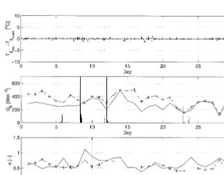
Two cases are studied at each site. In the first case half-Figure 1a. Time series of in situ measured ground temperature for the SGP97 experiment period at the El
Reno site (line). Estimates derived from NOAA 12 and NOAA 14 satellite overpasses based on AVHRR instrument are represented as symbols. The closed symbols are those satellite estimates that fall within the three hours period around the time of the maximum ground temperature occurrence.
hourly in situ observations of ground temperature are used as the measurements for the data assimilation in a nearly ideal, albeit rarely available configuration. Such a configuration is similar to the one considered in the study of Castelli et al.
[1999] where validation was performed with data from First International Satellite Land Surface Climatology Project (ISLSCP) Field Experiment (FIFE). The quality of FIFE val-idation data is likely to be superior to SGP 97 because several Figure 2a. Data assimilation results at the El Reno site. In this case the half-hourly in situ ground
temper-ature measurements are assimilated. (top) Time series of half-hourly errors in the estimation of ground temperature. (middle) Measurement (dashed line) and assimilation (solid line) estimates of surface latent heat flux. Also included in this panel are the trace records of precipitation. (bottom) Estimates ofabased on measuredEF (dashed line) and assimilation (solid line) are shown. The dailyaand latent heat values are averages over six hours around noon. Missing values in the measuredEFsequence correspond to days when the measured fluxes yieldedavalues far outside of the expected [0, 1] range.
surface flux measurement stations were used to form area averages. The data assimilation system performed with an RMSE of ;30 W m22
for daily latent heat flux estimation, which may be considered to be on the same order as the
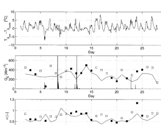
turbulent flux measurement uncertainty. In SGP 97 the avail-ability of surface heat flux stations is considerably more lim-ited. For this reason we take the assumption that data assim-ilation with half-hourly in situ measured ground temperature Figure 3a. The assimilation with half-hourly in situ ground temperature measurements at El Reno are used
for comparison with assimilation with satellite data only: (top) Time series of half-hourly errors in the estimation of ground temperature; (middle) Base case (solid line) and assimilation with satellite data esti-mates of surface latent heat flux. Also included are the trace records of precipitation. (bottom) Estiesti-mates of
abased on the base case assimilation (solid line) and assimilation with satellite data alone are shown. The dailyaand latent heat values are averages over 6 hours around noon. The solid symbols are those satellite estimates that fall within the 3 hours period around the time of the maximum ground temperature occurrence (as in Figures 1a and 1b).
provides a reasonable reconstruction of ground-truth for SGP 97. This reconstruction is therefore used as the base case for comparison of data assimilation with infrequently sampled sat-ellite data.
Figure 1a for El Reno and Figure 1b for Central Facility show the time series of in situ measured ground temperature. The symbols represent estimates made based on the satellite brightness temperatures measurements through theWan and Dozier [1996] algorithm. Estimates from those satellite mea-surements that fall within a 3-hour window of the time of peak daily ground temperature (NOAA 14 1430 LT overpass) are solid symbols. This distinction will prove to be important when the satellite data are assimilated, and it will be discussed later in this section.
The application of the data assimilation system with half-hourly ground temperature in situ observations as measure-ments is shown in Figure 2a (El Reno) and Figure 2b (Central Facility). Figures 2a and 2b (top) shows the error in the esti-mation of ground temperature which is the state of the system (4). The errors are plotted for each half hour of the 29 days. In both cases the errors are small (RMSE values are 0.648C at the El Reno and 0.258C at the Central Facility sites). The surface heat balance is reconstructed closely in the case of assimilation with half-hourly ground temperature observations. Figures 2a and 2b (middle) show the performance of the system in terms of latent heat flux. The estimation values are averaged over the 6 hours centered around noon (solid lines). The values derived from observations are represented by the dashed lines and rainfall events are included as bars. At the El Reno site (Figure 2a) the data assimilation and observed values of surface latent heat flux have day-to-day fluctuations that track closely but the values based on the EBBR system at the site are consistently above the data assimilation results with peaks reaching 600 W m22.
In order to assess whether there are possible biases in the turbulent heat flux measurements at each site, we make some scale comparisons with the possibly more reliable pyranometer measurements. The half-hourly measured peak net radiation observed at the El Reno is 730 W m22
. At the time of this peak the ground heat flux is changing sign and it is therefore near zero. With 730 W m22
of peak net radiation a half-hour peak surface latent flux measurement at El Reno of 760 W m22may
indicate positive bias and/or noise in the surface flux measuring system at this site. At Central Facility the peak net radiation experienced during the SGP 97 period was 650 W m22
, which is close to the observed peak latent heat flux of 625 W m22.
The Central Facility latent heat flux estimation is also biased (but less than in the case of El Reno). Nonetheless, the co-variability between the data assimilation and measurements show close tracking in Figure 2b (middle). The third panels in Figures 2a and 2b contain the daily values ofaaveraged for the 6 hours centered at noon in the diurnal cycle. Again the results based on measurements are denoted by dashed lines; they are estimated using (15). The values resulting from data assimila-tion are represented by solid lines. Because of inconsistencies and errors in observations of latent and sensible heat flux and surface micrometeorology, some of the values ofaobsfall out-side of the expected [0, 1] range. Biases in the turbulent heat flux measurements may cause other, largely unknown, errors in the estimation ofaobs. These errors can truly only be
charac-terized using a synthetic case study where the true condition is better known.
The values ofafrom the data assimilation of half-hourly in
situ measured ground temperature are closer to the available observation estimates for the Central Facility site (Figure 2b) when compared with the El Reno site (Figure 2a). This is consistent with the performances when surface latent heat flux is compared. Notably, in the case of Central Facility the day-to-day fluctuations, especially increases in the values ofa fol-lowing surface wetting by rain events, are captured well in the data assimilation results.
Use of low-Earth orbit satellite measurements in data as-similation is constrained by the temporal sampling problem. The AVHRR instrument on board the NOAA 12 and 14 satellite platforms are used here to provide the measurements in data assimilation. No other source of ground temperature observations are used. Figure 3a and 3b show the results of the data assimilation. The symbols represent the results of the data assimilation with measurements provided by AVHRR only. Again, the solid symbols are used to indicate those satellite ground temperature estimates that are made with available NOAA 14 1430 LT pass measurements. Figures 3a and 3b (top) contain the time series of errors in the estimation of half-hourly ground temperature with respect to the base case. The RMSE in the case of El Reno is 2.78C and in the case of Central Facility 2.48C. There also appears to be a slight bias during the period when midday satellite observations are sparse, but over the entire assimilation period the bias is small. The values are larger than the case in Figures 2a and 2b (even when compared to in situ measurements) mostly due to inad-equate sampling of the diurnal cycle in ground temperature. Figures 3a and 3b (middle) show the daytime surface latent heat flux. In both cases (El Reno in Figure 3a and Central Facility in Figure 3b) on days when the satellite overpass near the time of the peak daily ground temperature is available (identified by solid squares) the data assimilation estimates of surface latent heat flux are close to the base case. On days when no NOAA 14 1430 overpass measurements are available (identified by open squares), the performance is considerably worse. This indicates the importance of satellite sampling times for land data assimilation [Boni et al., 2001]. The maxi-mum surface ground temperature results from cumulative heating and hence it is sensitive to the partitioning of available energy into sensible and latent turbulent heat fluxes during the day. For this reason it is particularly important to have mea-surements near the time of maximum ground temperature (early afternoon) for land data assimilation of hydrologic vari-ables such asa.Boni et al. [2001] showed how the assimilation performance rapidly degrades when temperature sampling is done outside a three hours window around the time of diurnal peak. Some of the shortcomings in the estimation ofais also related to the error model used for it. We have assumed that errors in a are Gaussian distributed. The parameter a is bounded between zero and unity, and such an error model is convenient but can certainly pose some problems when errors are large. Furthermore we make comparisons with midday values ofaobsbecause during this period the turbulent fluxes
are strong and their measurement errors are a smaller fraction of the signal. Furthermore, during this period radiation is often not the limiting factor for surface evaporation, and therefore the day-to-day land control is more clearly evident.
for the sites (near 0.45) in order to estimate relative soil sat-uration in the normalized range [0, 1]. The standard deviation associated with the daily mean values reported byFamiglietti et al. [1999] refer to spatial variability at the data collection sites in El Reno and Central Facility. In order to compare the a
index of soil water to these in situ measurements the param-eterization ofNoilhan and Planton[1989] is used to transform
ainto relative soil saturation. The parameterization is a simple empirical model of relative humidity at the ground surface related to the surficial soil moisture [Noilhan and Planton, 1989, equation (28)]. It is only an approximation in order to translate theavalues into a reasonable expected surficial soil moisture. Figures 4a and 4b show the plot of estimated relative soil saturation (based on the data assimilation system with satellite measurements of ground temperature) and those measured at the El Reno and Central Facility sites, respec-tively. Again the open symbols are used to indicate days during which NOAA 14 1430 LT measurements are not available. Solid symbols represent estimated values during days when the available satellite data falls within the 3-hours window around the peak of diurnal ground temperature. Plot-scale spatial vari-ability of in situ soil moisture measurements are denoted by the one standard deviation error whiskers around the mean values in Figures 4a and 4b. The value estimated by data assimilation corresponds to the effective value within the ground resolution of the satellite measurements. Nonetheless, in both Figures 4a and 4b it is evident that estimates during days when the satellite data for ground temperature near the time of diurnal peak is available, the correspondence of
assim-ilation estimate of surface relative soil saturation and in situ measurements are superior to days when such data are missing.
6.
Summary
A statistically optimal land data assimilation system to min-imize the error of estimation when both model and measure-ments contain uncertainty is applied to two sites within the Southern Great Plains 1997 hydrology field experiment in northeast Oklahoma. The model consists of ground heat flow with surface energy balance at the land surface. It is used to provide dynamically consistent constraints on the estimation. Two case studies are considered, each with a different input stream of measurements. In the first and ideal case that also serves as the reference for subsequent comparisons, half-hourly in situ ground temperature observations are the mea-surements in the data assimilation. In the second case, satellite data from two low-Earth orbit satellite are the only source of measurements for ground temperature. Data from surface flux measuring stations and in situ soil moisture observations are used to validate the estimation results with ground-truth. It is shown that the data assimilation system performs well in cap-turing the day-to-day variations in the components of surface energy balance, ground temperature, and soil moisture or sur-face control on evaporation. Even though the precipitation data are withheld from the assimilation system, the wetting and drydown events are estimated and their effects on land control on evaporation are captured. On days when satellite data are available close to the time of peak diurnal ground temperature, the estimation is considerably improved over days when the cumulative daily heating is unknown.
Use of remotely sensed land surface temperature in a data assimilation framework to estimate fields of energy balance components and surface control on evaporation is feasible but considerably more refinements need to be made. The advan-tage of using land surface temperature data for this application in hydrology is that the satellite remote sensing of this variable Figure 4a. Comparison of soil moisture based on estimatea
and application of the model ofNoilhan and Planton[1989] at El Reno site. The ordinate is soil moisture observed in situ together with spatial standard deviation [Famiglietti et al., 1999]. Data assimilation with satellite data are stratified ac-cording to whether there are available satellite data near the peak of the diurnal ground temperature (closed circles for available measurements near the peak and open circles for lack of measurements near the peak). A characteristic soil porosity of 0.45 is used to compare relative soil saturation values.
has a long heritage, and it is possible to construct long-period data sets based on past and current sensors and platforms. The areas where the assimilation system can be improved include the following: (1) revised formulation of the uncertainty in the forward model and incorporation of more suitable character-ization of errors for the bounded parametera, (2) extensions to spatial fields so that the spatial covariance in the forcing and parameter fields can effectively condition the estimation, and (3) use of the synergy provided by multiple satellite platforms in order to better characterize the diurnal cycle of land tem-peratures.
Acknowledgments. This study was supported by NASA grant NAG8-1524, the MIT-CNR cooperative agreement, and sabbatical leave granted by MIT.
References
Bennett, A. F.,Inverse Methods in Physical Oceanography, Cambridge Univ. Press, New York, 1992.
Boni, G., F. Castelli, and D. Entekhabi, Sampling strategies and as-similation of ground temperature for the estimation of surface en-ergy balance components,IEEE Trans. Geosci. Remote Sens.,39(1), 165–172, 2001.
Castelli, F., D. Entekhabi, and E. Caporali, Estimation of surface heat flux and an index of soil moisture using adjoint-state surface energy balance,Water Resour. Res.,35(10), 3115–3126, 1999.
Deardorff, J. W., Efficient prediction of ground surface temperature and moisture with inclusion of a layer of vegetation,J. Geophys. Res.,
83, 1889 –1903, 1977.
Entekhabi, D., H. Nakamura, and E. G. Njoku, Solving the inverse-problem for soil moisture and temperature profiles by sequential assimilation of multifrequency remotely sensed observations,IEEE Trans. Geosci. Remote Sens.,32(2), 438 – 448, 1994.
Entekhabi, D., et al., An agenda for land-surface hydrology research and a call for the second International Hydrological Decade,Bull. Am. Meteorol. Soc.,80(10), 2043–2058, 1999.
Famiglietti, J. S., J. A. Deveraux, C. A. Laymon, T. Tsegaye, P. R. Houser, T. J. Jackson, S. T. Graham, M. Rodell, and P. J. van Oevelen, Ground-based investigation of soil moisture variability within remote sensing footprints during the Southern Great Plains
1997 (SGP97) Hydrology Experiment, Water Resour. Res., 35(6), 1839 –1851, 1999.
Galantowicz, J. F., D. Entekhabi, and E. G. Njoku, Tests of sequential data assimilation for retrieving profile soil moisture and tempera-ture from observed L band radiobrightness, IEEE Trans. Geosci. Remote Sens.,37(4), 1860 –1870, 1998.
Houser, P. R., W. J. Shuttleworth, J. S. Famiglietti, H. V. Gupta, K. H. Syed, and D. C. Goodrich, Integration of soil moisture remote sens-ing and hydrological modelsens-ing ussens-ing data assimilation,Water Resour. Res.,34(12), 3405–3420, 1998.
Hu, Z., and S. Islam, Prediction of ground temperature and soil mois-ture content by the force-restore method,Water Resour. Res.,31(10), 2531–2540, 1995.
Katul, G. G., O. B. Wendroth, M. B. Parlange, C. E. Puente, and D. R. Nielsen, Estimation of in situ hydraulic conductivity function from nonlinear filtering theory, Water Resour. Res., 29(4), 1063–1070, 1993.
McLaughlin, D. B., Recent developments in hydrologic data assimila-tion, U.S. Natl. Rep. Int. Union Geod. Geophys. 1991–1994, Rev. Geophys.,33, 995–1003, 1995.
Noilhan, J., and S. Planton, A simple parameterization of land surface processes for meteorological models,Mon. Weather Rev.,117, 536 – 549, 1989.
Reichle, R., D. B. McLaughlin, and D. Entekhabi, Variational data assimilation of microwave radiobrightness observations for land sur-face hydrologic applications,IEEE Trans. Geosci. Remote Sens., in press, 2000a.
Reichle, R., D. B. McLaughlin, and D. Entekhabi, Hydrologic data assimilation with the ensemble Kalman Filter,Mon. Weather Rev., in press, 2000b.
Wan, Z., and J. Dozier, A generalized split-window algorithm for retrieving land-surface temperature from space,IEEE Trans. Geosci. Remote Sens.,34(4), 892–905, 1996.
G. Boni, Centro di Ricerca in Monitoraggio Ambientale, Savona, Italy ([email protected])
F. Castelli, Dipartimento di Ingegneria Civile, Universita` degli Studi di Firenze, Florence, Italy.
D. Entekhabi, Department of Civil and Environmental Engineering, Massachusetts Institute of Technology, 48-331 Ralph M. Parsons Lab-oratory, Cambridge, MA 02139. ([email protected])

![Figure 4a.Comparison of soil moisture based on estimate1999]. Data assimilation with satellite data are stratified ac-cording to whether there are available satellite data near thepeak of the diurnal ground temperature (closed circles foravailable measureme](https://thumb-ap.123doks.com/thumbv2/123dok/3282233.1746499/9.612.284.544.45.284/comparison-assimilation-satellite-stratied-available-temperature-foravailable-measureme.webp)
