EXPERIMENTAL RESEARCH ON
ACCURACY OF AEROTRIANGULATION FOR UAV IMAGERY
LI Ling a, *, LI Ying-Cheng a, DING Xiao-Bo a
a
China academy of surveying and mapping, Beijing ,China- ([email protected], [email protected], [email protected])
Commission VII WGVII/6
KEY WORDS: UAV imagery, Aerotriangulation, Geolord-AT, PixelGrid, Photo-control Points Distribution
ABSTRACT:
In this paper, the experimental research utilized UAV imageries of two areas, assessed the accuracy of aerial triangulation on the basis of different photo-control points distributions using two kinds of software (Geolord-AT and PixelGrid). The experimental results show that the accuracy of aerotriangulation of UAV imagery can be satifactory to the accuracy of 1:500 scale topographic maps in the intensive control conditions. The experimental processing steps and results provide experience and reference for production.
* Corresponding author. This is useful to know for communication with the appropriate person in cases with more than one author. 1. INTRODUCTION
The UAV photography has the unique advantages of fast getting, low cost, low altitude and high resolution, which can effectively solve the acquisition problem of aerial image in numerous small towns, villages and large factories and mines of china in real time. In recent years, the UAV photography technology has been rapid development. The UAV system is widely used in surveying and mapping, agriculture and forestry, land, ocean, environment, hydrology, meteorology and disaster emergency etc. Especially with the UAV system industrial application of china in 2009, the UAV photogrammetric technology development and innovation is pushed. Aerotriangulation is a critical phase in photogrammetric mapping. Its accuracy affects the final mapping products. In this paper, the experimental research utilized UAV imageries of two areas, assessed the accuracy of aerotriangulation on the basis of different photo-control points distributions using two kinds of software, Geolord-AT and PixelGrid.
2. EXPERIMENTAL CONDITIONS
2.1 Software
In this research work, we do the aerotriangulation experiment separately by the softwares of Geolord-AT and PixelGrid. The software of Geolord-AT is developed by the Chinese Academy of Surveying and Mapping. It has the functions of blunder detection and adjustment computation, the gross errors detection, location and revision. Using this software large number of tie-points significantly improved the accuracy and reliability of the bundle adjustment. The software of PixelGrid is a new generation efficiently mapping system developed by the Chinese Academy of Surveying and Mapping. It processes data both from satellite and airborne cameras, similar to ISTAR PixelFactoryTM. And the main features of the software are the sparse or no GCPs block adjustment based on RFM and automatical aerotriangulation based on multi-image matching.
2.2 Test Site
In this research work, test sites are located in Heilongjiang Province, two separate villages, surrounded by a large area of arable land. Less characteristic feature in the edge of the areas make it difficult to select the control points.
Area 1: The rectangle block covers 0.19km2, and it is consist of 2 strips and 18 aerial photographs with the ground resolution of 0.06m taken with ZC-1 UAV system (see Figure 1). The flight rout is form southwest to northeast. Relative flying height is 225m.The Forward overlap is 64% -70%. The side overlap is 35% -45%.
Area 2: The rectangle block covers 0.55km2, and it is consist of 4 strips and 46 aerial photographs with the ground resolution of 0.55m taken with ZC-1 UAV system (see Figure 2). The flight rout is form southwest to northeast. Relative flying height is 209m.The Forward overlap is 64% -70%. The side overlap is 35% -45%.
Figure 1. Flight rout graph of area 1 International Archives of the Photogrammetry, Remote Sensing and Spatial Information Sciences,
Volume XL-7/W1, 3rd ISPRS IWIDF 2013, 20 – 22 August 2013, Antu, Jilin Province, PR China
Figure 2. Flight rout graph of area 2
3. EXPERIMENTAL RESEARCH
Accuracy experimental research on aerotriangulation of high-resolution UAV imagery has three main processing steps: Camera Calibration and Distortion Correction, Photo Control Survey and Aerotriangulation Experiment.
3.1 Camera Calibration and Distortion Correction
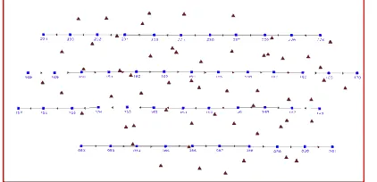
In this research work, the sensor of the ZC-1 UAV system is Canon EOS 5D Mark II camera of 24 mm focal length, 6.4μm ×6.4μm pixel resolution and 5616×3744 pixels image size. Since the camera is a non-metric digital camera, camera calibration is necessary before doing aerial triangulation. We use the camera calibrator module of Australis software in which the bundle block adjustment method is used. The software is developed by the university of Melbourne. In our case, the calibration has a final total error of 1.19µm (0.19 pixels), the largest marking residual of 4µm (0.625pixel) and the matching point uniformly distributed (see Figure 3). Through camera calibration we obtain the calibrated parameters include focal length (f) of the lens, location of the principal point (xp, yp), three radial distortion function coefficients (k1, k2, k3) and two decentring distortion function coefficients (p1, p2) (see Table 1).
Figure 3. Image point distribution of camera calibration
Table 1. Camera calibration parameters
When the calibrated parameters are known, aerial photographs are corrected for the distortion using TOPDistor1.0 software developed by China TopRS Technology Co., Ltd. And we get the corrected aerial photographs.
3.2 Photo-control Points Survey
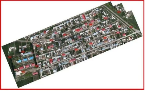
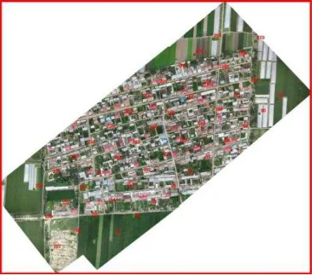
Field observations of photo control point were carried out using the single reference CORS system of a county of Heilongjiang Province. This system is running stable. It can provide real-time position service of the centimeter level accuracy in our test sites. In order to achieve the purpose of the experiment, the full field control point distribution were used, that set four control points in each stereo pairs. According to the requirement of Specification for Field Work of Low-altitude Digital Aerophotogrammmetry, try to distribute field control points on multiple aerial photographs of two strips and lay the control point on the low wall, low housing or the ground. The position of the control point should be at the corner point of clear objects or the intersecting point of fine linear features, should not be at the curved objects, non stationary objects and blurred objects on the image. At the same time considering the influence on the GPS Survey Accuracy, the position of the control point should avoid from the obstacles, such as tall buildings and trees, the high-voltage wire, microwave station, etc. In this research work, we get 30 photo-control points over area 1 (see Figure 4) and 57 photo-control points over area 2 (see Figure 5).
Figure 4. Photo-control points distribution of area 1 Calibration Parameters Value Focal Length (mm) f 24.3978 Principal Point (mm) XP 0.0998
YP 0.1200
Radial Distortion Function Parameters
K1 1.85076e-004 K2 -2.73472 e-007 K3 -5.16962 e-011 Decentring Distortion
Function Parameters
P1 2.1621-004 P1 5.0951-005 International Archives of the Photogrammetry, Remote Sensing and Spatial Information Sciences,
Volume XL-7/W1, 3rd ISPRS IWIDF 2013, 20 – 22 August 2013, Antu, Jilin Province, PR China
Figure 5. Photo-control points distribution of area 2
3.3 Aerotriangulation Experiment
In this research work, we do the aerotriangulation experiment separately by the softwares of Geolord-AT and PixelGrid. The photo-control point distributions are described as following:
1. Orientation points are at the strip ends within the terminal stereomodel.
2. Orientation points are at intervals along strips, which is from 1 stereomodel basis to 8 stereomodel bases.
3. Orientation points are at intervals cross strips, which is from 1 strip to 2 strips.
4. Other redundant control points are checking points. There are eight photo-control point distributions for area 1(see Table 2 and Table 3), and ten photo-control point distributions for area 2(see Table 4 and Table 5).
Table 2. Accuracy of area 1 by GeoLord-AT software
Interv
Table 3. Accuracy of area 1 by PixelGrid software
Interv
Table 4. Accuracy of area 2 by GeoLord-AT software
Interv
Table 5. Accuracy of area 2 by PixelGrid software
The experimental results shows as following:
1. The analyzing of the aerotriangulation accuracy according to
the Specifications for Aerotriangulation of Digital
Aerophotogrammetry.
The accuracy can be satisfactory for the accuracy of 1:500 scale topographic maps by photo-control point distribution of 1 stereomodel basis and 1 Strip.
The accuracy can be satisfactory for the accuracy of 1:1000 scale topographic maps by photo-control point distributions of 1 to 8 stereomodel bases and 1 Strip. The accuracy can be satisfactory for the accuracy of 1:1000 scale topographic maps by photo-control point distributions of 1 to 6 stereomodel bases and 2 Strips.
2. The comparison of the aerotriangulation accuracy at the same photo-control points density.
The accuracy is better by photo-control point distribution of 2 stereomodel bases and 1 Strips than that by photo-control point distribution of 1 stereomodel basis and 2 Strips.
The accuracy is better by photo-control point distribution of 2 or 4 stereomodel bases and 2 Strips than that by photo-control point distribution of 4 or 8 stereomodel bases and 1 Strip.
It shows that the interval cross strips of the photo-control point affect the aerotriangulation accuracy. So the interval cross strips International Archives of the Photogrammetry, Remote Sensing and Spatial Information Sciences,
Volume XL-7/W1, 3rd ISPRS IWIDF 2013, 20 – 22 August 2013, Antu, Jilin Province, PR China
should be taken into account when estimating accuracy of different photo-control point distribution in Specification for
Field Work of Low-altitude Digital Aerophotogrammmetry.
3. The comparison between the experimental accuracy and the estimating accuracy in Specifications for Field Work of
Low-altitude Digital Aerophotogrammmetry.
The experimental horizontal accuracy is consistent with the estimating horizontal accuracy by photo-control point distributions of 1 to 2 stereomodel bases and 1 strip. The experimental accuracy is different from the estimating accuracy by other photo-control point distributions.
It shows that the dynamic instability of camera curtain shutter affect the aerotriangulation accuracy when the interval is large.
3.4 Summary
The experimental results show that the accuracy of aerotriangulation of UAV imagery can be satifactory to the measurement accuracy of 1:500 scale topographic maps in the intensive control conditions. Because the accuracy of aerotriangulation of UAV imager is influenced by many factors such as weather, test site, aerial flight, software process capability and the technical level of operators etc., the paper experimental results are for the UAV imagery used in this experiment. But the experimental processing steps and results can provide experience and reference for production. With the wide application and the data enriching of UAV, the National Administration of Surveying, Maping and Geoinformation had plan to make revisions on low-altitude digital aerial photogrammetric specification according to the experiences of field measurements accumulated from production units.
4. CONCLUSION
With the opening of the lower airspace and continuous improvement of UAV system, as a new type of data acquisition means, the UAV won all customers with the characteristics of fast and flexible. It pushes the UAV photogrammetric technology development and innovation. The final products of UAV are closer to the standard products of surveying and mapping. The UAV system provide a more accurate and economy surveying and mapping services and security for the construction of a new countryside, key project planning and construction, agriculture and forestry, environmental protection, disaster emergency etc.
5. REFERENCES
LI Ying-Cheng, ZHAO Ji-Cheng, DING Xiao-Bo, 2005.A light airborne remote sensing system for landuse application and land resource management. Remote Sensing Information, 4, pp.49- 52.
LI Ying-Cheng, 2008. The application and developing prospects of digital remote sensing systems of low altitude photograph. Science of Surveying and Mapping, 33, pp.28-31.
LI Ying-Cheng etc., 2010, CH/Z 3003 Specifications for Office Operation of Low-altitude Digital Aerophotogrammetry, Surveying and Mapping Press, Beijing.
LI Ying-Cheng etc., 2010, CH/Z 3004 Specification for Field
Work of Low-altitude Digital Aerophotogrammmetry,
Surveying and Mapping Press, Beijing.
DENG Guo-Qing etc., 2009, GB/T 23236 Specifications for
Aerotriangulation of Digital Aerophotogrammetry, China
Zhijian Publishing House, Beijing.
International Archives of the Photogrammetry, Remote Sensing and Spatial Information Sciences, Volume XL-7/W1, 3rd ISPRS IWIDF 2013, 20 – 22 August 2013, Antu, Jilin Province, PR China