Date: 2011-12-19 Reference number of this document: OGC 11-093r2 http://www.opengis.net/doc/ows8-aviation-architecture
Category: Public Engineering Report Editor:Johannes Echterhoff
OGC
®OWS-8 Aviation Architecture Engineering Report
Copyright © 2011 Open Geospatial Consortium, Inc. All Rights Reserved. To obtain additional rights of use, visit http://www.opengeospatial.org/legal/.
Warning
This document is not an OGC Standard. This document is an OGC Public
Engineering Report created as a deliverable in an OGC Interoperability Initiative and is not an official position of the OGC membership. It is distributed for review and comment. It is subject to change without notice and may not be referred to as an OGC Standard. Further, any OGC Engineering Report should not be referenced as required or mandatory technology in procurements.
Document type: OpenGIS® Engineering Report Document subtype: NA
Preface
This document is a deliverable of the OGC Web Services (OWS) Initiative - Phase 8 (OWS-8). It describes the architecture that was implemented in the OWS-8 Aviation thread.
This document is a deliverable for the OGC Web Services 8 (OWS-8) testbed activity. OWS testbeds are part of OGC's Interoperability Program, a global, hands-on and collaborative prototyping program designed to rapidly develop, test and deliver proven candidate standards or revisions to existing standards into OGC's Standards Program, where they are formalized for public release. In OGC's Interoperability Initiatives,
international teams of technology providers work together to solve specific geoprocessing interoperability problems posed by the Initiative's sponsoring organizations. OGC
Interoperability Initiatives include test beds, pilot projects, interoperability experiments and interoperability support services - all designed to encourage rapid development, testing, validation and adoption of OGC standards.
The OWS-8 sponsors are organizations seeking open standards for their interoperability requirements. After analyzing their requirements, the OGC Interoperability Team
recommend to the sponsors that the content of the OWS-8 initiative be organized around the following threads:
* Observation Fusion
* Geosynchronization (Gsync)
* Cross-Community Interoperability (CCI) * Aviation
More information about the OWS-8 testbed can be found at:
http://www.opengeospatial.org/standards/requests/74
OGC Document [11-139] “OWS-8 Summary Report” provides a summary of the OWS-8 testbed and is available for download:
Copyright © 2011 Open Geospatial Consortium, Inc. All Rights iii License Agreement
Permission is hereby granted by the Open Geospatial Consortium, Inc. ("Licensor"), free of charge and subject to the terms set forth below, to any person obtaining a copy of this Intellectual Property and any associated documentation, to deal in the Intellectual Property without restriction (except as set forth below), including without limitation the rights to implement, use, copy, modify, merge, publish, distribute, and/or sublicense copies of the Intellectual Property, and to permit persons to whom the Intellectual Property is furnished to do so, provided that all copyright notices on the intellectual property are retained intact and that each person to whom the Intellectual Property is furnished agrees to the terms of this Agreement.
If you modify the Intellectual Property, all copies of the modified Intellectual Property must include, in addition to the above copyright notice, a notice that the Intellectual Property includes modifications that have not been approved or adopted by LICENSOR. THIS LICENSE IS A COPYRIGHT LICENSE ONLY, AND DOES NOT CONVEY ANY RIGHTS UNDER ANY PATENTS THAT MAY BE IN FORCE ANYWHERE IN THE WORLD.
THE INTELLECTUAL PROPERTY IS PROVIDED "AS IS", WITHOUT WARRANTY OF ANY KIND, EXPRESS OR IMPLIED, INCLUDING BUT NOT LIMITED TO THE WARRANTIES OF MERCHANTABILITY, FITNESS FOR A PARTICULAR PURPOSE, AND NONINFRINGEMENT OF THIRD PARTY RIGHTS. THE COPYRIGHT HOLDER OR HOLDERS INCLUDED IN THIS NOTICE DO NOT WARRANT THAT THE FUNCTIONS CONTAINED IN THE INTELLECTUAL PROPERTY WILL MEET YOUR REQUIREMENTS OR THAT THE OPERATION OF THE INTELLECTUAL PROPERTY WILL BE
UNINTERRUPTED OR ERROR FREE. ANY USE OF THE INTELLECTUAL PROPERTY SHALL BE MADE ENTIRELY AT THE USER’S OWN RISK. IN NO EVENT SHALL THE COPYRIGHT HOLDER OR ANY CONTRIBUTOR OF
INTELLECTUAL PROPERTY RIGHTS TO THE INTELLECTUAL PROPERTY BE LIABLE FOR ANY CLAIM, OR ANY DIRECT, SPECIAL, INDIRECT OR CONSEQUENTIAL DAMAGES, OR ANY DAMAGES WHATSOEVER RESULTING FROM ANY ALLEGED INFRINGEMENT OR ANY LOSS OF USE, DATA OR PROFITS, WHETHER IN AN ACTION OF CONTRACT, NEGLIGENCE OR UNDER ANY OTHER LEGAL THEORY, ARISING OUT OF OR IN CONNECTION WITH THE IMPLEMENTATION, USE, COMMERCIALIZATION OR PERFORMANCE OF THIS INTELLECTUAL PROPERTY. This license is effective until terminated. You may terminate it at any time by destroying the Intellectual Property together with all copies in any form. The license will also terminate if you fail to comply with any term or condition of this Agreement. Except as provided in the following sentence, no such termination of this license shall require the termination of any third party end-user sublicense to the Intellectual Property which is in force as of the date of notice of such termination. In addition, should the Intellectual Property, or the operation of the Intellectual Property, infringe, or in LICENSOR’s sole opinion be likely to infringe, any patent, copyright, trademark or other right of a third party, you agree that LICENSOR, in its sole discretion, may terminate this license without any compensation or liability to you, your licensees or any other party. You agree upon termination of any kind to destroy or cause to be destroyed the Intellectual Property together with all copies in any form, whether held by you or by any third party. Except as contained in this notice, the name of LICENSOR or of any other holder of a copyright in all or part of the Intellectual Property shall not be used in advertising or otherwise to promote the sale, use or other dealings in this Intellectual Property without prior written authorization of LICENSOR or such copyright holder. LICENSOR is and shall at all times be the sole entity that may authorize you or any third party to use certification marks, trademarks or other special designations to indicate compliance with any LICENSOR standards or specifications.
This Agreement is governed by the laws of the Commonwealth of Massachusetts. The application to this Agreement of the United Nations Convention on Contracts for the International Sale of Goods is hereby expressly excluded. In the event any provision of this Agreement shall be deemed unenforceable, void or invalid, such provision shall be modified so as to make it valid and enforceable, and as so modified the entire Agreement shall remain in full force and effect. No decision, action or inaction by LICENSOR shall be construed to be a waiver of any rights or remedies available to it.
Contents
Page1 Introduction ... 1
1.1 Scope ... 1
1.2 Document contributor contact points ... 2
1.3 Revision history ... 2
5 OWS-8 Aviation Architecture - Overview ... 11
6 Workflows ... 12
7 Component Descriptions ... 15
7.1 AIXM 5.1 WFS-T ... 15
7.1.1 Snowflake ... 15
7.1.1.1 Components Overview ... 15
7.1.1.2 Component functionality ... 16
7.1.1.3 Data available via the components ... 17
7.1.1.4 Accomplishments ... 17
7.1.1.5 Challenges ... 17
7.1.2 Comsoft ... 18
7.1.2.1 Overview ... 18
7.1.2.2 Purpose in OWS-8 ... 18
7.1.2.3 WFS 2.0 conformance ... 19
7.1.2.4 New and specific functionality and other contributions to OWS-8 ... 19
7.1.2.5 Digital NOTAM generation ... 21
7.1.2.6 Metadata support ... 21
7.1.3 Luciad ... 21
7.1.4 WFS Service Capabilities - Summary ... 21
7.2 WXXM 1.1 WCS 2.0 ... 24
7.2.1 GMU ... 24
7.3 FPS ... 24
7.3.1 Carmenta ... 24
7.3.2 Envitia ... 25
7.3.2.1 Introduction ... 25
7.3.2.2 Standard Functionality ... 25
7.3.2.3 Specific/new Functionality ... 25
7.3.2.4 Available Data ... 25
Copyright © 2011 Open Geospatial Consortium, Inc. All Rights v
7.3.2.6 Challenges Faced ... 26
7.3.2.7 OWS-8 Accomplishments ... 26
7.3.3 Luciad ... 27
7.4 Event Service ... 28
7.4.1 UM-IfGI ... 28
7.4.1.1 Interfaces ... 28
7.4.1.2 Changes to the Event Service Implementation ... 29
7.4.2 IDS ... 30
7.4.2.1 Architecture ... 30
7.4.2.2 Services Description ... 31
7.4.2.3 Configuration ... 32
7.5 Registry Service ... 32
7.5.1 Galdos ... 32
7.5.1.1 Key features ... 33
7.6 Aviation Client ... 33
7.6.1 Luciad ... 33
7.6.1.1 Challenges & Accomplishments ... 37
7.6.2 Frequentis ... 38
7.7 WXXM Client ... 41
7.7.1 Atmosphere ... 41
7.8 AIXM 5.1 Validation Tools ... 42
7.8.1 Lisasoft ... 42
7.8.1.1 Schematron Rules ... 43
7.8.1.2 Use in OWS-8 ... 43
7.9 AIXM Performance Assessment Tools ... 44
7.9.1 AtoS ... 44
7.9.1.1 The EXI-TTFMS framework ... 44
7.9.1.2 Test cases ... 45
7.9.1.3 Results ... 45
7.9.1.4 Future work ... 46
7.10 Access Control System ... 46
7.10.1 TUM ... 46
8 Access Control System within the OWS-8 Aviation Architecture ... 48
8.1 Service-oriented Security Architecture ... 48
8.2 Initiation of the Access Control Process ... 48
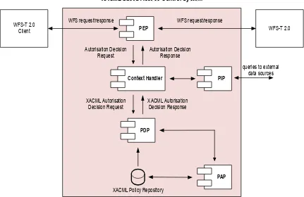
8.3 Architecture of XACML based Access Control Systems ... 50
9 Aviation Event Architecture ... 53
9.1 Encoding of Aviation Events ... 53
9.1.1 Digital NOTAM ... 53
9.1.1.1 Temporality and Uniqueness ... 53
9.1.1.2 Spatial Extent ... 54
9.2 Web Service Notification and SOAP ... 54
9.3 Eventing Components and Dataflow ... 55
9.3.2 Data Provision ... 57
9.3.3 Data Processing ... 58
9.4 Dynamic Filtering ... 58
9.4.1 Creation of a Dynamic Spatial Filters ... 59
9.4.2 Provision of Aircraft Position Data ... 62
9.4.3 Processing of Position Data ... 62
9.5 Observed Issues and Drawbacks ... 62
9.5.1 Dealing with the AIXM Temporality Model ... 63
9.5.1.1 Event Service Conformance Classes ... 63
9.5.1.2 WFS Support for Dynamic Features ... 63
9.5.2 Interoperability between Event Services ... 64
9.5.3 Additional Observations ... 64
10 Lessons Learned ... 66
10.1 AIXM / Temporality Model ... 66
10.1.1 Clarify Snapshot Definition ... 66
10.1.1.1 Problem Statement and Description ... 66
10.1.1.2 Recommendation ... 68
10.1.2 Clarify Snapshot Encoding for Feature Property with Schedule ... 68
10.1.3 Extract - Extending the Snapshot Concept ... 73
10.1.3.1 Introduction ... 73
10.1.3.2 Use Case ... 74
10.1.3.3 Computation ... 75
10.1.3.4 Encoding ... 79
10.1.3.5 Summary ... 83
10.1.4 Reconsider Rules for Handling Changes to Multi Occurring Properties ... 84
10.1.4.1 Delta for multi-occurring property with schedule ... 84
10.1.4.2 Temporary change of multi-occurring property that overlaps a permanent change ... 84
10.1.4.3 Recommendation ... 89
10.1.5 Incorporate Extension Property Handling ... 90
10.1.6 Temporality Model as Standalone Specification ... 96
10.1.6.1 Purpose of the Temporality Model ... 96
10.1.6.2 Why the Temporality Model should become a Standalone Concept ... 96
10.1.6.3 What is needed? ... 97
10.2 SOAP/WSDL support in OWS ... 102
10.2.1 SOAP Complexity ... 102
10.2.2 Bootstrapping a SOAP based OWS ... 103
10.2.3 SOAP Version ... 104
10.2.4 Security ... 105
10.2.5 Message Size ... 105
10.2.6 Conclusion ... 106
10.3 Unit of Measure Handling in Filter Expressions ... 106
10.3.1 Background ... 106
Copyright © 2011 Open Geospatial Consortium, Inc. All Rights vii
10.3.3 Conclusion ... 109
11 Scenarios ... 109
12 Accomplishments ... 111
13 Annex A – Detailed Scenario Descriptions ... 113
13.1 Dispatch and Planning ... 113
13.2 Increasing Situational Awareness for Flight Planners, Pilots and Operation Centers ... 114
13.3 Probabilistic Weather in Decision Making ... 114
Figures
Page Figure 1 – OWS-8 Aviation Architecture – High-Level Overview ... 11Figure 2 – Common component interactions to retrieve and disseminate data ... 12
Figure 3 – Component interactions to portray data ... 13
Figure 4 – Overview of the Snowflake aviation component architecture ... 15
Figure 5 – Dataflow of Event Notifications ... 30
Figure 6 – IDS Event Service Architecture ... 31
Figure 7 – Styling based on availability and contamination type ... 35
Figure 8 – Class-based ICAO airspace styling ... 35
Figure 9 – Integrated data browser ... 36
Figure 10 - 3D visualization ... 36
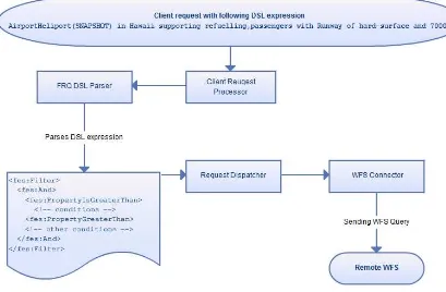
Figure 11 – Using Domain Specific Query (DSL) expressions to perform queries with FES 2.0 filter expressions at WFS ... 39
Figure 12 – Retrieved EEVI data in the client front-end ... 39
Figure 13 – Creating selection on map with Carmenta FPS Airport layer enabled ... 40
Figure 14 – Guidance TAF visualizer - Pilot View ... 41
Figure 15 – Guidance TAF visualizer - Scientific View ... 42
Figure 16 – DuckHawk Testing Framework – Overview ... 43
Figure 17 – Candidate components for the initialization of the access control process ... 49
Figure 18 – Architecture of an XACML based Access Control System ... 51
Figure 19 – AIXMBasicMessage transporting a Digital NOTAM ... 53
Figure 20 – Components involved in OWS-8 Eventing ... 55
Figure 21 – Data flow between components of the Event Architecture ... 56
Figure 23 – State tracking of the dynamic spatial buffer ... 61
Figure 24 – Snapshot with Baseline and Tempdelta ... 67
Figure 25 - Snapshot with Baseline, Tempdelta and new Permdelta without according Baseline update ... 68
Figure 26 – State of an AIXM feature defined via its timeslices and time of interest of an Extract of that feature ... 76
Figure 27 –State of an AIXM feature defined via its timeslices - timeslices relevant for the Extract with given time of interest are depicted in purple. ... 78
Figure 28 –Timeslices relevant for an Extract (depicted in purple) whose time of interest is partially outside the feature lifetime. ... 79
Figure 29 – Extract whose time of interest is during the feature lifetime - encoded as a list of Snapshots ... 80
Figure 30 – Extract whose time of interest overlaps the feature lifetime - encoded as a list of Snapshots ... 81
Figure 31 – Extract including temporary changes by schedule - encoded as a list of Snapshots ... 83
Figure 32 – Permanent change of a multi occurring feature property occurring during the valid time of a temporary change of that property ... 85
Figure 33 – Handling the delta overlap issue for a multi-occurring property without schedule ... 86
Figure 34 – Options for solving the delta overlap issue for a multi-occurring property with schedule ... 87
Figure 35 – Solving the delta overlap issue for a multi-occurring property with schedule via the schedule itself ... 88
Figure 36 – Solving the delta overlap issue for a multi-occurring property with schedule by encoding the temporary change via two Tempdeltas ... 89
Figure 37 – Special Use Airspace Feature extension (for AIXM 5.1) ... 90
Figure 38 – Special Activity Airspace extension (for AIXM 5.1) ... 91
Tables
PageTable 1 – WFS Service and Operation Capabilities ... 21
Table 2 – WFS Filter Capabilities ... 22
Listings
PageCopyright © 2011 Open Geospatial Consortium, Inc. All Rights ix
Listing 2 – FES 2.0 subscription ... 57
Listing 3 – Example digital NOTAM Notification ... 58
Listing 4 – Generic restrictive view ... 60
Listing 5 – Update for the position of an aircraft ... 62
Listing 6 – Subscribe response ... 64
Listing 7 – Airspace with activation based on schedule ... 69
Listing 8 – Airspace Snapshot with full schedule ... 71
Listing 9 – Airspace Snapshot with single value without schedule ... 72
Listing 10 – AIXM Airspace Baseline with both SUA and SAA extension elements ... 92
OGC
®OWS-8 Aviation Architecture Engineering Report
1 Introduction
1.1 Scope
This OGC®
document describes the architecture implemented in the OWS-8 Aviation thread, including general workflows. The document contains a summary description of the various components within the architecture. An introduction to the Access Control System is provided. Furthermore, the document describes relevant aspects of handling events and notifications. Lessons learned – for example regarding the AIXM Temporality Model – as well as scenarios and accomplishments are documented as well.
Attention is drawn to the possibility that some of the elements of this document may be the subject of patent rights. The Open Geospatial Consortium Inc. shall not be held responsible for identifying any or all such patent rights.
1.2 Document contributor contact points
All questions regarding this document should be directed to the editor or the contributors:
Name Organization
Johannes Echterhoff (editor) iGSI
Matthes Rieke IfGI
Date Release Editor Primary
clauses modified
Description
2011-08-24 0.1 Johannes Echterhoff
all initial word version 2011-09-09 0.2 Johannes
Echterhoff
throughout integrated a number of contributions and completed various sections
2011-09-30 1.0 Johannes Echterhoff
1.4 Future work
The following items were identified for consideration in future initiatives:
Data validation via WPS - The work performed on validating the Digital NOTAM Event Specification (DNES) revealed that integrating a validation tool to check DNOTAM business rules on given dnotam:Event instances into the Aviation service infrastructure can be facilitated by encapsulating the validation process in a web service.
Development of a WPS profile for validation of XML instances against their respective schema and possibly existing business rules appears to be a valuable effort - not only for the Aviation domain but also for the general OGC community - see future work item “Invocation of validation tools” in the DNOTAM ER for a more detailed discussion of this idea
Testing and integration of automatic unit of measure conversion
functionality - Automated UoM conversion as described in section 10.3 would improve the filter capabilities of OGC Web Services. Especially when the UoM of a feature property is not constant, the mechanism helps to perform meaningful comparison operations. The discussion performed in OWS-8 on this topic did not cover all relevant aspects (see section 10.3 for further details). Therefore, a future activity should further develop the automatic UoM conversion mechanism, integrate it into actual OGC Web Service implementations (like WFS and Event Service that support OGC Filter Encoding Specification) and test it. Eventually, the mechanism can then be integrated in or become an extension of the OGC Filter Encoding Specification.
Investigate, improve and provide guidance on service bootstrapping – During OWS-8 participants made experience with bootstrapping of SOAP based web services. Apparently there is a need for additional experience and guidance both for web service providers and clients on bootstrapping to such services. While the traditionally used OGC service bindings – HTTP GET (KVP) and HTTP POST – are sufficiently described via an OGC service’s Capabilities document, this is not the case for SOAP based web services. Here, the WSDL document provides additional information that has not been considered for an OWS Capabilities document (such as SOAP version and operation action identifiers). Section 10.2.2 explains the issue and possible solutions in more detail.
services deployed on it.
Work on SOAP and WSDL for OGC Web Services has been performed in
previous OGC initiatives (see OGC 08-009r1). This work should be reviewed and updated/extended to take into account IT standards such as WS-Addressing, WSDL 2.0 and the WS-I BasicProfiles.
Temporality Model as standalone specificationand better support for time varying data in OGC/ISO standards – The AIXM Temporality Model defines encoding as well as business rules that enable applications to keep track of time varying data, in this case of AIXM features and their properties. Refactoring the Temporality Model into a standalone specification/standard would be beneficial for the following reasons: a) enable re-use of the concepts defined by the
Temporality Model in other domains that deal with time varying data, b)
improved maintenance/governance of the Temporality Model itself, c) improved interoperability and usability when handling and managing time varying data via (web) services. Section 10.1.6 explains this in more detail. The ideas and
suggestions presented in that section should be considered in the future. Improved usability and interoperability in model design and encoding as well as
management and access of time varying information are key benefits of the suggested refactoring. Section 10.1.6 also outlines how this could be achieved by revising/extending a set of OGC and ISO standards.
Aviation Event Architecture
o Dynamic spatial filtering – Future work on the dynamic spatial filter should cover processing as well as (architecture) modeling and interface definition aspects. A combination of temporal filters and dynamic spatial filters is imaginable. For instance, an SAA in a near upcoming part of the flight route may be activated but the start time of the activation is three hours from now. Obviously, a pilot or dispatcher is not interested in such an Event as the airplane will have passed this airspace already three hours before the activation takes place (given that the route segment can be traversed in three hours). Missing such events because of application of dynamic filtering must be regarded from a security aspect as well; however, this mechanism can help clients to receive and act only upon those events that are of interest. Additionally, the design of the EML should be improved to reduce the current complexity. This accompanies a general review of the EML model with respect to dynamic event patterns and parameters. In general, alternative approaches to using EML could be investigated.
o Simplification of subscription methods – Specific requirements from a client perspective should be included in the design of subscriptions. This includes the simplification of interfaces as a client should not deal with such complex markup languages if only a rather small and specific subset of the given functionality is used. This concerns the way that filter
discussed such as domain specific filter functions and stored subscriptions in Event Services. Work topics could cover the development of interfaces as well as general investigations on contents for such stored subscriptions. o Provision of aircraft position updates – in the case that the receipt of
aircraft positions using ADS-B is considered as appropriate several architectural aspects need to be taken into consideration. From an Event Service point of view receiving a vast amount of position updates from different aircrafts is problematic due to performance limitations. The event architecture could benefit from some sort of broker service for position updates. An Event Service receiving a subscription for a specific flight route (with an assigned CallSign) could then subscribe at such a broker service for position updates of the aircraft with this call sign. Thus, an Event Service only receives those position updates which are relevant for the currently registered subscriptions. In general, it may also be reasonable to hide such a broker architecture behind the façade of a possible
authoritative Event Service which would provide a global interface for subscribing to DNOTAMs.
o Conceptual work on enrichment of thin events within an Event Service – during this testbed the developed enrichment design has been applied while processing events. What is currently missing is the
conceptual integration of this feature into the overall model of the Event Service. Future work on the enrichment of thin events should consider the integration into the service metadata. A client using the Event Service would then be able to determine if it is capable of pulling additional information from a (WFS) data store, thus being able to define appropriate subscription filters. This would also imply the definition if an Event Service supports the retrieval of AIXM feature Extracts for a certain period of time (see section 10.1.3 for further details on “Extract”).
1.5 Foreword
This document is a deliverable of the OGC Web Services (OWS) Initiative - Phase 8 (OWS-8). It describes the general architecture that was implemented in the OWS-8 Aviation thread. It also contains summaries of the components developed for and used in OWS-8 Aviation. Furthermore, it documents issues, lessons learned as well as
2 References
The following documents are referenced in this document. For dated references, subsequent amendments to, or revisions of, any of these publications do not apply. For undated references, the latest edition of the normative document referred to applies. OWS-8 Engineering Reports:
[OGC 11-061] OWS-8 AIXM Metadata Guidelines Engineering Report [OGC 11-072] OWS-8 Aviation - WXXM Interim Engineering Report
[OGC 11-073] OWS-8 Aviation: Guidance for retrieving AIXM 5.1 data via an OGC WFS 2.0
[OGC 11-086] OWS-8 Aviation Thread – Authoritative AIXM Data Source Engineering Report
[OGC 11-089] OWS-8 Engineering Report - Guidelines for ICAO portrayal using SLD/SE
[OGC 11-091] OWS-8 WXXM/WXXS Schema Validation Results [OGC 11-092] OWS-8 Report on Digital NOTAM Event Specification [OGC 11-097] OWS-8 AIXM Compression Performance Benchmarking ER [OGC 11-106] OWS-8 Digital NOTAM Refactoring Report
[OGC 11-107] OWS-8 Domain Modeling Cookbook Other OGC Documents:
[OGC 08-009r1] OWS 5 SOAP/WSDL Common Engineering Report [OGC 10-079r3] OWS-7 Aviation Architecture ER
[OGC 10-195] Requirements for Aviation Metadata
[OGC 10-196r1] Guidance on the Aviation Metadata Profile [OGC 11-060] Use of GML in aeronautical data
[OGC 11-055] SAA Pilot Study Engineering Report Aviation Documents:
Digital NOTAM Event Specification, ed. 1.0 (Proposed Release), online at
http://www.aixm.aero/public/standard_page/digital_notam_specifications.html
AIXM - Temporality Model v1.0, online at
http://www.aixm.aero/public/standard_page/download.html
AIXM - AIXM Application Schema Generation, online at
http://www.aixm.aero/public/standard_page/download.html
AIXM - UML to XML Schema Mapping v1.1, online at
http://www.aixm.aero/public/standard_page/download.html
The Unified Code for Units of Measure (UCUM), online at
http://aurora.regenstrief.org/~ucum/ucum.html
3 Terms and definitions
For the purposes of this report, the following terms and definitions apply. 3.1
Extract
Information on the complete status of an AIXM feature during a given time interval. 3.2
Dynamic property
Synonyms: dynamic data, time varying property, time varying data
4 Abbreviated terms
ACARS Aircraft Communications Addressing and Reporting System ACS Access Control System
ADR Authorization Decision Request
ADS-B Automatic Dependent Surveillance-Broadcast AIM Aeronautical Information Management AIP Aeronautical Information Publication
AIRAC Aeronautical Information Regulation and Control AIXM Aeronautical Information Exchange Model AIXM-TM AIXM Temporality Model
AOA ACARS over AVLC
ATC Air Traffic Control
ATN Aeronautical Telecommunication Network AVLC Aviation VHF Link Control
BBOX Bounding Box
CEP Complex Event Processing COTS Commercial Off the Shelf CRS Coordinate Reference System CSW Catalog Service for the Web DCMI Dublin Core Metadata Initiative
DGIWG Digital Geographic Information Working Group DNES Digital NOTAM Event Specification
DNOTAM Digital NOTAM
DSL Domain Specific Language
ebRIM Electronic Business Registry Information Model EFB Electronic Flight Bag
EML Event Pattern Markup Language ES Event Service
FPS Feature Portrayal Service
GeoJSON Geographic JavaScript Object Notation GFM General Feature Model
GML Geography Markup Language HTTP Hypertext Transfer Protocol HTTPS HTTP Secure
IATA International Air Transport Association ICAO International Civil Aviation Organization ISO International Organization for Standardization JSON JavaScript Object Notation
JVM Java Virtual Machine KML Keyhole Markup Language
METAR Meteorological Aerodrome Report (may vary) NAWX North American Weather extension to WXXM NOTAM Notice to Airmen
OASIS Organization for the Advancement of Structured Information Standards OGC Open Geospatial Consortium
OWS OGC Web Service
PAP Policy Administration Point PDP Policy Decision Point PEP Policy Enforcement Point PIP Policy Information Point POA Plain Old ACARS RIA Rich Internet Application SAA Special Activity Airspace SE Symbology Encoding SES Sensor Event Service
SIGMET Significant Meteorological Information SLD Styled Layer Descriptor
SOA Service Oriented Architecture SSL Secure Sockets Layer
SUA Special Use Airspace
TAF Terminal Aerodrome Forecast TLS Transport Layer Security
UCUM Unified Code for Units of Measure UoM Unit of Measure
URI Uniform Resource Identifier URL Uniform Resource Locator VHF Very High Frequency
W3C World Wide Web Consortium WCS Web Coverage Service
WFS Web Feature Service WFS-T WFS-Transactional WMS Web Map Service WPS Web Processing Service WS-A Web Services Addressing
WSDL Web Services Description Language
WS-I Web Services Interoperability Organization WS-N Web Services Notification
WXXM Weather Information Exchange Model XACML Extensible Access Control Markup Language XML Extensible Markup Language
5 OWS-8 Aviation Architecture - Overview
The OWS-8 Aviation thread architecture can be separated into three tiers (see Figure 1): The Client Tier contains the client applications.
The Business Process Tier contains components that offer services on top of the Access Tier: discovery, portrayal, authentication and authorization, validation and publish/subscribe
The Access Tier contains Web Feature Services serving AIXM 5.1 data as well as WFSs and Web Coverage Services serving WXXM and other data.
Figure 1 – OWS-8 Aviation Architecture – High-Level Overview
6 Workflows
This section provides a high-level overview of the common interactions between client and service components in the OWS-8 Aviation service infrastructure.
The following sequence diagram shows common interactions for retrieving and disseminating data that is of interest to a client.
Figure 2 – Common component interactions to retrieve and disseminate data
The interactions shown in Figure 2 have the following purpose:
1.0: The client retrieves feature data from the WFS (e.g. via the GetFeature operation). The client can request general information, for example on airspaces and airports. Using specific filter criteria it can also query the WFS to identify suitable alternate/diversion airports (e.g. by searching for airports that have a passenger terminal, re-fueling facilities, a hard-surface runway of certain required minimum length etc). Weather data formatted as METARs and TAFs can also be served by and requested from a WFS.
3.0: Whenever a WFS detects a relevant change in its feature data (for example that an airspace got a new activation or that a runway was closed) it generates a notification that represents the change (for example encoded as a DNOTAM) and sends it to the Event Service.
3.1: The Event Service processes the content of the notification and matches it against all subscriptions to detect matches.
3.2: If the data matches a given subscription, then the Event Service notifies the recipient defined for the subscription (here it is the client).
4.0: The client processes the data that it either retrieved from a WFS or received from an Event Service and usually displays it. Portrayal of the data is performed according to some style.
Various options exist how the portrayal of data according to styles can be achieved in the Aviation Architecture. These options are described in the following sequence diagram.
The interactions shown in Figure 3 have the following purpose:
1.0: A client that is capable of performing style based data portrayal may first have to retrieve suitable styles from the Registry.
1.1: With style information being available, the client can then portray the data and display it.
2.0: Some clients may not be capable of creating style based portrayals themselves. These clients can use the Feature Portrayal Service to perform the job for them.
2.1: First of all, the FPS retrieves the necessary feature data from the WFS – either a WFS that is set for a pre-configured layer or a WFS chosen by the client.
2.2: If the client requested that the portrayal is performed with a certain style that is stored in a Registry, the FPS retrieves it.
7 Component Descriptions
7.1 AIXM 5.1 WFS-T
7.1.1 Snowflake
7.1.1.1 Components Overview
Snowflake Software’s GO Publisher commercial off-the shelf (COTS) product is comprised of a series of flexible, scalable components capable of supporting the
transformation and data exchange requirements of aeronautical information systems (see Figure 4).
Figure 4 – Overview of the Snowflake aviation component architecture
Aeronautical data were received from a wide range of sources and integrated into a consolidated database. The consolidated database schema is an AIXM 5.1 schema storing BASELINE, TEMPDELTA and PERMDELTA timeslices. Supporting metadata were also defined based on user scenarios defined in the metadata guidelines document. The Snowflake Software component architecture consisted of three components that were used in the authoritative data source, event architecture and flight planning scenarios.
7.1.1.1.1 WFS 2.0 (read-only)
Current History WFS: within this configuration a single feature is published representing each real world object. Each feature contains only BASELINE and TEMPDELTA timeslices that are valid now and in the future.
Full History WFS: within this configuration a single feature is published representing each real world object. Each feature contains all BASELINE and TEMPDELTA timeslices that have ever been published.
1 Feature – 1 Timeslice WFS: within this configuration multiple features are published that represent the real world objects. Each feature contains only one timeslice: BASELINE, TEMPDELTA or PERMDELTA that representing the state of the real world object or an event that resulted in permanent or temporary change to the feature over a specified time period.
7.1.1.1.2 WFS-T 2.0 (transactional)
A separate transactional WFS 2.0 instance was established to support the authoritative data source and event architecture threads. The WFS-T was established to support the insert of features containing TEMPDELTA timeslices representing i) SAA Activation Schedules (create, modify, approve, disapprove), ii) Navaid Unservicable, iii) Runway Closure and iv) Airport Surface Contamination.
The WFS-T was integrated into the data maintenance architecture for the consolidated database. On insert of a Feature containing a TEMPDELTA timeslice a series of processes are then triggered to auto generate additional information to publish the data via the WFS and Event Publisher in real-time.
7.1.1.1.3 Event Publisher
The Event Publisher is composed of two components:
GO Publisher Agent: a server-side bulk data publishing system that generates event messages
Event Pusher: this registers with one or more event services as an event source and pushes the messages generated to the event service brokers
Publication of events is triggered by the insertion of a timeslice into the database. GO Publisher Agent generates a Digital NOTAM Event which is published into a directory on the server. The Event Pusher polls this directory and on receipt of an Event message, it then pushes the message to the Event Service Brokers.
7.1.1.2 Component functionality
No new component functionality was developed for either GO Publisher WFS or the Event Publisher during OWS-8. GO Publisher WFS currently implements a large proportion of the OGC WFS 2.0 specification (Table x) and the Event Publisher
Within OWS-8, the aim was to further evaluate the effectiveness of the basic mandatory WFS 2.0 operations and full filter encoding (FE 2.0) to retrieve AIXM 5.1 data for the various flight planning and dispatch scenarios identified.
7.1.1.3 Data available via the components
The OWS-8 consolidated database consists of data containing BASELINE and TEMPDELTA timeslices from the following sources:
EANS: the EANS AIXM 5.1 was made accessible via the Comsoft WFS. Some of the feature types relevant for the scenario were harvested and loaded into the consolidated database using GO Loader.
Eurocontrol/LFV/ FAA Airports GIS data and AMDB Obstacles data: these data provided for use within OWS-6 and 7 were published from the original project databases as AIXM 5.1 and loaded into the consolidated database using GO Loader.
Eurocontrol Digital Snowtam Trial 2011: A global dataset ofAirportHeliport AIXM 5.1 features were harvested on an ad hoc basis from the WFS established for the Digital Snowtam trial.
FAA NASR Subscriber data: pre-operational data feed providing access to AIXM 5.0 SAA messages updated every 56 days inline with the AIRAC cycle. These were loaded into initially into an SAA 5.0 database then published out as AIXM 5.1 and loaded into the consolidated database using GO Loader.
FAA SAMS SUA Data feed: operational data feed providing access to SAA Activation schedules (.csv) updated every minute.
Test Events: a set of example test events were created to support the various scenarios that were inserted into the consolidated database via the WFS-T 2.0
7.1.1.4 Accomplishments
Several key accomplishments were developed within OWS-8 within the data maintenance and publication architecture developed by Snowflake:
Consolidated data from multiple sources, published using different AIXM 5.1 extension schemas into a single authoritative database and provided access to these data via the WFS 2.0 and Event Publisher
Extended the database to include some example reverse associations for
AirportHeliport, Runway, Runway Element and Airspace features and tested the benefits of reverse associations for improved data retrieval
Configured the WFS-T to support the authoritative data source and flight planning scenarios enabling users to insert TEMPDELTA timeslices (create, authorize, modify, cancel/disapprove) into the database. On insert additional processes were triggered to auto generate additional properties (i.e. sequenceNumber,
correctionNumber, gml:id) for publication via Event Publisher and WFS
7.1.1.5 Challenges
1. Simplifying data retrieval requiring multiple queries
Although GO Publisher WFS implements many of the optional query parameters and filter expressions defined in the WFS specification however, it emerged that to
successfully retrieve AIXM 5.1 data based on the scenarios requires the implementation of: i) Local resolve and wfs:valueOf() and ii) join query predicates. Both of these query parameters enable users to place queries that traverse properties containing xlink references to generate the response. Such queries are important in AIXM 5.1 as the relationships between features are one-directional so they should remove the requirement for reverse associations. It should also remove the requirement to submit multiple
requests to obtain a result.
2. Retrieving specific timeslices
The WFS specification supports versioning which enable users to retrieve specific versions of a feature from within a data store, however, it does not support the ability to support the retrieval of specific timeslices from dynamic features. This is currently a serious issue; proposals for the support of timeslice retrieval are being developed in the WFS Guidance ER.
7.1.2 Comsoft
7.1.2.1 Overview
COMSOFT’s Aeronautical Information Management Database (CADAS-AIMDB) is a fully featured AIXM 5 database. It has been especially developed to natively support all concepts of AIXM 5. It is designed to serve as a base for integrating AIM products and components such as electronic AIP, Charting, NOTAM Office, or Briefing with a central Aeronautical Database.
A design principle is the interoperability with other systems. As the database is the core of any integrated AIM solution an open interface that can be used independently from any platform and programming language is one of the key features. For an optimal support of AIXM 5 CADAS-AIMDB provides the CAW-interface. In OWS-7, support for the emerging WFS 2.0 standard was added and further improved in OWS-8.
7.1.2.2 Purpose in OWS-8
In OWS-8, the CADAS-AIMDB is used as WFS data store and DNOTAM event source. As a WFS data store, it hosts static (BASELINE and PERMDELTA time slices) and dynamic data (TEMPDELTA time slices). Time slices can be retrieved from and stored to the WFS. The retrieval operations support complex filters built of logical, spatial, temporal and comparison operators.
7.1.2.3 WFS 2.0 conformance
One objective of OWS-8 is to stress the WFS 2.0 standard and to apply it on AIXM 5.1 data. During this project, not all features of WFS 2.0 could be linked to a use case. Instead of reaching a maximum of WFS 2.0 conformance, COMSOFT focused on the implementation of the actual features used in the demo scenarios.
A detailed list of the supported WFS operations and capabilities can be found in Table 1.
7.1.2.4 New and specific functionality and other contributions to OWS-8
Basic WFS support for CADAS-AIMDB was developed in OWS-7. In OWS-8, the support was extended and new features were implemented.
7.1.2.4.1 Support for advanced GML objects
In the document "Use of GML for aviation data", version 0.3, a detailed explanation of the usage of GML in the aviation domain is given together with implementation hints. The following table lists the compliance of CADAS-AIMDB with that document:
Section Support in
Partially No inheritance from gml:boundedBy. Developed for OWS-8.
4) Positions Yes
5) Lines and Surfaces
Yes Geodesic interpolation is always used. The
"gml:Geodesic" element is not supported.
5.1) Encoding parallels
Yes Only EPSG:4326 and CRS:84 are supported.
5.2.3) Arc by edge
Yes Developed for OWS-8
5.2.4) Arc by
centre point
Yes Developed for OWS-8
5.2.5) Circle by center point
Yes
6) Point references
No The specification is not yet clear about how to implement and interpret references at geometry level as this is a deviation from the general AIXM principle of having
xlink:href associations towards the feature level only. References based on gml:ids cannottake the temporality of the information into account as gml:ids are linked to a
7) Geographical
border references
specific property in a specific time slice.
7.1.2.4.2 Challenges in the support for advanced GML objects
Common spatial databases do not natively support curved geometries. They support points, straight lines and complex geometries built upon them only (e.g. line strings, polygons). Curved geometries can only be stored in an approximated form by dividing them into straight lines. While implementing advanced GML objects for OWS-8, COMSOFT discovered the need for a precision parameter to spatial query operators. These findings are documented in OGC 11-073, chapter “Precision of spatial filters”.
7.1.2.4.3 Generation and retrieval of SNAPSHOT time slices
SNAPSHOT time slices can be seen as virtual properties of a feature. This is because they can be calculated from BASELINE, PERMDELTA and TEMPDELTA time slices. The SNAPSHOT generation involves a complex merge process, in which time slices have to be ordered, overlaid and filtered.
CADAS-AIMDB already supported the retrieval and filtering of SNAPSHOT time slices through its CAW interface. In OWS-8, COMSOFT made the SNAPSHOT support available for the WFS 2.0 interface. As SNAPSHOTs play a central role in the AIXM temporality model, this work included effort in the domain of extending the WFS specification to support it, which can be found in OGC 11-073, chapter "Configuring a WFS 2.0 to serve AIXM 5.1”. CADAS-AIMDB also already supports a proposed extension of the SNAPSHOT definition which is SNAPSHOTs for time periods. See sections 10.1.3 and 10.1.3.4.1 for details.
7.1.2.4.4 Advancement of the AIXM profile for WFS 2.0
COMSOFT contributed to the work on the proposed AIXM profile for WFS 2.0, which benefitted from its operational experience. This included a proposal for a new temporal
query type as an alternative to the complex extensions needed otherwise to enable a WFS to serve AIXM 5.1 data. This alternative interface is derived from COMSOFT’s CAW interface which proved its value in productive systems. Details can be found in OGC 11-073 chapter “Use case oriented approach to time slice retrieval with WFS 2.0”. Further conceptual work was done in the fields of
gml:id uniqueness (see OGC 11-073 chapter “Guidelines for ensuring gml:id uniqueness”)
reverse associations (see OGC 11-073 chapter “Implications of Reverse Associations”)
7.1.2.5 Digital NOTAM generation
CADAS-AIMDB supports the generation of DNOTAM events following the
specification given in the document "Digital NOTAM Event Specification, Proposed Release, Increment 1". When TEMPDELTA time slices are inserted via the Transaction operation, DNOTAMs with digital encoding are created and sent to interested parties by a Web Service message. In OWS-8 these are event brokers that themselves categorize, forward and distribute events to registered clients on a subscriber-publisher basis. In the current implementation, only a basic support for DNOTAMs is available. No scenario identification or validation of business rules is performed.
7.1.2.6 Metadata support
In OWS-8, support for the storage and retrieval of metadata on time slice level was added to CADAS-AIMDB.
7.1.3 Luciad
Luciad provided an OGC Web Feature Service to retrieve Special Activity Airspace (SAA) data provided by the FAA. The WFS supports filtering on properties, spatial filtering (for instance, to retrieve airspaces that potentially affect a flight route), and basic temporal filtering.
One of the challenges with serving the SAA data is the handling of the separate airspace components that are combined using constructive geometry operations, such as unions and subtractions. The Luciad WFS supports the additional processing required for exact spatial queries on such complex airspaces. This allows you to evaluate exactly whether a point lies inside or outside of a particular airspace.
The supplied data also contained links between features, for instance from an air traffic control service to the airspace for which it provides a traffic separation service. These links pose additional issues when they are encountered by client applications. This issue is avoided by the WFS by automatically converting all links to local links to features that were included with the response.
7.1.4 WFS Service Capabilities - Summary
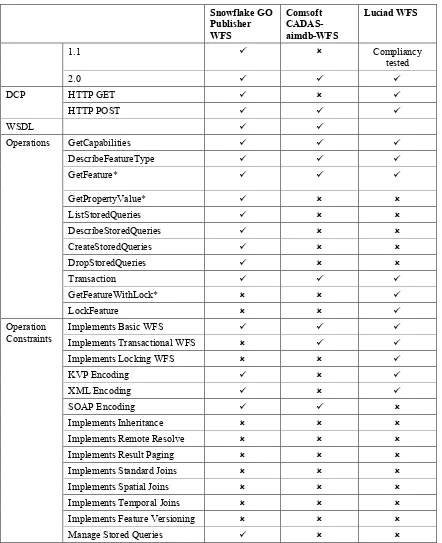
A Web Feature Service supports a certain set of functionality, for example operations, operation parameters, feature types, filter operations as well as operands. This section provides a summary of the respective capabilities for each WFS that is introduced in the previous sections.
Table 1 – WFS Service and Operation Capabilities
Snowflake GO
Operations GetCapabilities
DescribeFeatureType
Implements Transactional WFS
Implements Locking WFS
KVP Encoding
XML Encoding
SOAP Encoding
Implements Inheritance
Implements Remote Resolve
Implements Result Paging
Implements Standard Joins
Implements Spatial Joins
Implements Temporal Joins
Implements Feature Versioning
Manage Stored Queries
* None of the WFS components support the “resolve” parameter specified in clause 7.6.4 of OGC 09-025r1 / ISO/DIS 19142
Table 2 – WFS Filter Capabilities
Snowflake GO Publisher WFS
Comsoft CADAS-aimdb-WFS
Snowflake GO
Temporal Operand gml:TimePeriod gml:TimePeriod gml:TimeInstant
The NOAA GOES Wind Products WCS for OWS-8 Aviation is providing access to the NOAA GOES satellite derived high density Wind products: Cloud Drift Wind and Water Vapor Wind.
These products consist of point-based measurements about the air temperature, air pressure, wind direction and wind speed, along with the exact geo-location where the measurement was performed.
This WCS exposes GetCapabilities, DescribeCoverage and GetCoverage operations. For the GetCoverage operation, users may define the bounding box and temporal range that is of interest. The range subset on a specific field can also be defined. There are two formats that this WCS can return: WXXM and KML.
For more detailed information about this WCS, go to:
http://geobrain.laits.gmu.edu/ows8/aviationWCS.html
7.3 FPS
7.3.1 Carmenta
The Carmenta FPS is built on Carmenta Server, which is an OGC-compliant geoserver implementing WMS, WFS and CSW interfaces. In OWS-8 it is used as an FPS for portrayal of ICAO symbology using SLD/SE.
Within OWS-8 support for AIXM 5.1 has been implemented by building a generic XML reader identifying GML-features.
7.3.2 Envitia
7.3.2.1 Introduction
The Envitia FPS comprises an implementation of the WMS specification. Versions 1.0.0, 1.1.1 and 1.3.0 are supported. The FPS functionality is provided by a plugin to the
Envitia Web Services WMS component. The purpose of this Envitia FPS is to support the OWS-8 Aviation demonstration participants in creating their demonstrations.
The available data and capabilities of the component can be explored by visiting the Envitia Services website1 and following the Services link (top right corner) to the FAA Demonstrator2. This demonstrator has been configured as the OWS-8 Aviation Demo portal. The portal is best viewed in Mozilla Firefox.
7.3.2.2 Standard Functionality
Interaction with this component is exclusively via KVP-encoded HTTP GET requests. The FPS connects to the available WFS components to obtain AIXM data. The data is then rendered using an FPS client specified SLD. The SLDs are stored in a portrayal registry.
7.3.2.3 Specific/new Functionality
In addition to the standard WMS capabilities, the Envitia FPS component also allows clients to request terrain and airspace profiles or “cross sections” as they are named in the Envitia Services portal. This can be seen by browsing to the OWS-8 Aviation Demo portal. Simply open any of the Common Operating Pictures available, select the Cross Section tab and then use the XZ tool to select a start and end point for the profile query. No new FPS functionality was added to Envitia’s components as part of this project.
7.3.2.4 Available Data
Snowflake, Luciad and COMSOFT WFS have been consumed and are available as rendered WMS layers from the FPS when a valid SLD is specified in the WMS request. The data has been filtered loosely to the areas of interest, namely Estonia and Hawaii. Also available are supporting background raster images for these areas. Available imagery can be discovered by browsing the Envitia OWS-8 Aviation Demo portal.
1 http://services.envitia.com
Feature types available from the FPS are: Airspaces
Airports / Heliports Navaids
Runways Routes Taxiways
7.3.2.5 Component Configuration
Envitia’s ChartLink application is the nucleus of the system. It is running on the server and is accessed via the Envitia Web Services WMS component in order to service requests.
The data from the source WFSs provided by Luciad, COMSOFT and Snowflake has been pre-processed and cached.
7.3.2.6 Challenges Faced
One of the main challenges faced with Envitia’s approach was matching up third party SLDs with the internal storage format of the cached data in ChartLink. ChartLink
provides the images required in servicing FPS/WMS requests and is therefore responsible for rendering using SLDs. Its internal storage method is not synonymous with the GML and XPath aspects related to the usage of the SLD and WFS standards.
Due to the complexity of some of the portrayal issues, and to the lack of support for some of the optional WFS capabilities, such as XPath resolution and join predicates, most of them were not possible to display in the demonstration portal.
Other issues identified have been articulated in the Aviation Portrayal ER (see OGC 11-089).
7.3.2.7 OWS-8 Accomplishments
A number of the more complex portrayal issues were explored with the use of this component. This supported the significant contribution to the Aviation Portrayal Engineering Report from Envitia.
7.3.3 Luciad
Luciad provides an OGC Feature Portrayal Service (FPS) to portray GML data. An FPS service takes away the burden of parsing and visualizing raw GML data served by a WFS. It remotely loads and renders data, and returns the result as an image that can be shown by any modern web browser.
The FPS was provided as an in-kind contribution because it entirely relied on standards and did not need any code specific to the project. In fact, the same setup is also used in other OGC projects.
Using an FPS in an application consists of the following high-level steps: 1. Determine the WFS server that is to be contacted by the FPS 2. Construct a query for the WFS server to select the required data
3. Create a Symbology Encoding (SE) feature type style to render the data from the WFS server
4. Wrap the WFS query together with the SE style in a request and send it to the FPS The major drawback of this scenario is that it does not allow for caching of the data on the server, mainly because it cannot be predicted what data will be requested by the user. To circumvent this, the FPS can also offer layers, much like a traditional WMS, and allow dynamic styling of those layers. This is also supported by our FPS component. One other possible improvement would be an FPS that shares a data store with a WFS. This would allow advanced querying and styling capabilities, but would not support interaction with multiple WFS services.
Another useful enhancement would be support for vector-based output formats, such as KML and GeoJSON. This could also benefit map display performance, as the client application would no longer need to request new images every time a user zooms or pans.
Technical specifications
The FPS was built using the OGC-compliant web service components provided by Luciad. The most important features include:
Support for OGC WMS/FPS versions 1.1.1 and 1.3.0, including GET and POST requests
Support for OGC WFS versions 1.0, 1.1 and 2.0, including SOAP requests Support for OGC SLD/SE versions 1.0 and 1.1
7.4 Event Service
7.4.1 UM-IfGI
The implementation of the Event Service (ES) provided by the Institute for
Geoinformatics is based on the OGC Sensor Event Service discussion paper (OGC 08-133). The source code is maintained and provided in collaboration with the 52°North
Initiative for Geospatial Open Source Software GmbH. Following the Publish/Subscribe
paradigm of OASIS’ Web Service Notification (WS-N) family of standards it acts as a notification broker. The IfGI ES has been used in aviation threads of former OGC initiatives such as OWS-6, OWS-7 and the FAA SAA Dissemination Pilot.
7.4.1.1 Interfaces
The ES consists of three endpoints. The PublisherRegistrationManager can be used to register data providers at the ES instance but is not used in this testbed and hence not described.
Endpoint Available Methods URL
SesPortType – broker
To enable SOAP bootstrapping both endpoints provide a WSDL description (see section 10.2.2) using HTTP Get method (<endpoint-url>?wsdl).
Besides the GetCapabilities method, all available methods are defined by OASIS WS-N. The methods used in this testbed are described in the following table.
Method Description involved OWS-8
Component Notify Used to push a NotificationMessage to the ES. The
contents are Digital NOTAM Events or position update messages of an aircraft (sent by clients for demo
purposes) and separated into different topics
(NOTAM-Topic, AircraftPosition-Topic). This method does not use request-response communication, as notifications are pushed to the ES.
WFS providers, Clients (for demo purposes)
Subscribe Used to define a subset of all incoming notifications. A subset can be defined using Topic filters, XPath
Expressions and FES 2.0 filters. A
SubscriptionReference is returned to the client, enabling the management of it. A Subscription can have an InitialTermination time (encoded as a period or a date time) to define its lifetime.
Unsubscribe Used to cancel a Subscription (e.g. when the flight has arrived).
Clients
7.4.1.2 Changes to the Event Service Implementation
Compared to the ES used in the latest OGC testbeds some major improvements have been made during this testbed. All the subsequently described features are demonstrated in the OWS-8 Aviation scenarios including the use of digital NOTAM event encoding and enrichment of these, position updates of the aircraft, multiple concurrent
subscriptions, subscription lifetime handling and use of the Unsubscribe operation.
7.4.1.2.1 Enrichment of Thin Events
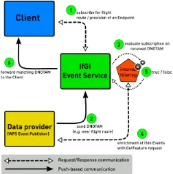
To enable filtering on all properties of a Digital NOTAM with regard to the Temporality Model of AIXM the thin Events received by the ES need to be enriched (see section 9.5.1.1). The approach is one of the major changes to the ES compared to the former testbeds and is described in the following; see also Figure 5.
Figure 5 – Dataflow of Event Notifications
7.4.1.2.2 Dynamic Subscriptions
The dynamic filter functionality as described in section 9.4 has been implemented
prototypically within this testbed. Besides the enrichment of events, this is another major change in the ES compared to OWS-7. Using the EML patterns the ES recognizes the subscription as a dynamic one and takes - in addition to the digital NOTAMs - the AircraftPositionUpdates into consideration for internal filtering. The internal
representation of the subscription is continuously updated according to the retrieved positions. Thus, only those events matching the remaining flight route are forwarded to the clients.
7.4.2 IDS
The Event Service is provided by IDS Ingegneria dei Sistemi S.p.A. It is being developed in the context of OWS-8. The IDS Event Service allows distributing AIXM messages to interested clients. Clients can filter messages by message topic or by geometry. In addition to a push mode, the IDS Event Service also offers a pull mode, so that clients can retrieve messages even if not being continuously connected to the network.
7.4.2.1 Architecture
The IDS Event Service implements the OASIS WS-Brokered Notification specification. The entities involved are as follows:
Broker: The Broker is the entity in charge of disseminating notifications on behalf of Publishers to Consumers. Its role is routing Notifications (created by
Publishers) to Consumers who own a matching subscription.
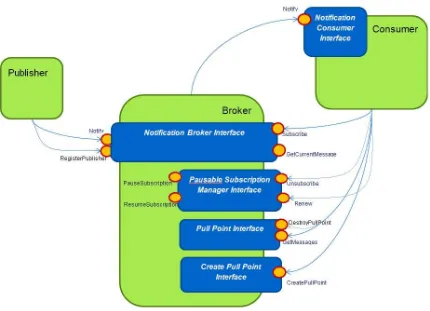
Consumer: A Consumer is an endpoint designated to receive Notifications produced by a Publisher, delivered by a Broker as a result of a subscription. A Subscription represents the relationship between a Consumer and the Broker, including any filtering parameters such as Topic and spatial filter expressions. All communication with the IDS Event Service is done via SOAP messages over HTTP. The IDS Event Service architecture is described in Figure 6.
Figure 6 – IDS Event Service Architecture
In the OWS8 scenario, the IDS Event Service implements a Notification Broker; publishers are AIXM message producers; consumers are the client applications.
7.4.2.2 Services Description
The operations offered by the IDS Event Service are:
Subscribe: Using this method a Notification Consumer can express its interest to receive a subset of notifications. Such a subscription may include a filter statement to specify the subset of notifications of interest. The implemented filters are by Topic and OGC Filter expression.
GetCurrentMessage: This method returns the last message that was posted to a specific topic.
RegisterPublisher/DestroyRegistration: These methods are used to register/unregister a notification producer at the Event Service. These methods are not mandatory to be used in the OWS-8 scenario, so these functionalities are not implemented in the IDS Event Services.
Renew: This method allows changing the subscription’s termination time in advance.
Unsubscribe: This method cancels a specific subscription.
PauseSubscription/ResumeSubscription: These methods allow a Notification Consumer to suspend/resume its interest to receive notifications.
CreatePullPoint/DestroyPullPoint:These methods allow a Notification Consumer to create/cancel a PullPoint resource. A PullPoint is an endpoint that accumulates Notification Messages and allows a Notification Consumer to retrieve accumulated Notification Messages.
GetMessages: This method is used by the Notification Consumer to retrieve accumulated Notification Messages in the PullPoint resource previously created.
7.4.2.3 Configuration
The IDS Event Service is provided as a web application deployable under a Web Server (it is tested under Apache Tomcat). It needs a data base to store incoming messages and to save a report about sent messages result.
7.5 Registry Service
7.5.1 Galdos
Galdos INdicio™ is a Web Registry Service (WRS) that implements the Open Geospatial Consortium (OGC) ebRIM profile of the Catalogue Service for the Web, 2.0.2
specification (CSW-ebRIM 1.0.1, OGC doc 07-110r4). Galdos refers to this service as WRS for shorthand notation. The OGC Catalogue Service (OGC document 07-006r1) is an abstract catalogue standard that defines the basic notion of Record and has multiple profiles.
The INdicio Web Registry was used in OWS-8 for hosting Styling information encoded using the OGC Styled Layer Descriptor (SLD) standard that are used mainly by
component Feature Portrayal Services (FPS) in OWS-8, namely by the following
to create User accounts and to publish styling resources. GetRecord was then used to retrieve the resources by users and the FPS components. No issues were encountered during the OWS-8 initiative.
Unlike conventional geographic catalogues, INdicio™ is highly configurable and can be readily deployed to manage a wide variety of objects.
7.5.1.1 Key features
Open standards-based
Easy installation and configuration
Easy management and monitoring capabilities Secure and flexible interface
Supports multilingual application domains Support for large transactions
INdicio™ ships with a CSW-ebRIM Basic Extension Package which provides a variety of useful objects for geospatial applications including:
Services taxonomy (source: ISO 19119 “Geographic information – Services”) Country codes (source: ISO 3166-1 “Codes for the representation of names of countries and their subdivisions – Part 1: Country codes”)
Geographical regions (source: UN Statistics Division) Feature codes (source: DGIWG FDD)
Property categories based on Dublin Core (source: DCMI metadata terms) INdicio™ is inherently extensible and can be adapted to multiple application requirements by using OGC CSW layered on top of ebRIM. Galdos Systems Inc. is constantly developing new extension packages, such as the CRS Extension Package, as well as custom extension packages on request.
The Flexible and secure query interface: Supports spatial queries using GML 3.1.1 Supports XACML specification
Supports role-based access control Full text search of XML resources
7.6 Aviation Client
7.6.1 Luciad
The application provides its users with flexible means for efficient queries to WFS, FPS, and WCS services for aeronautical and weather data. These queries can be based on a geographical region and/or a time interval. Additionally, an interface to the Event Service guarantees that the user is kept informed of any updates.
The most important feature is the ability to support flight planning and dispatch
operations through the use of aeronautical data in the AIXM format and weather data in the WXXM format, both delivered by WFS services. Both data types contain time dependent information that can be used by the client to adapt the visualization to the relevant time. This increases the situational awareness, either in-flight or during pre flight planning.
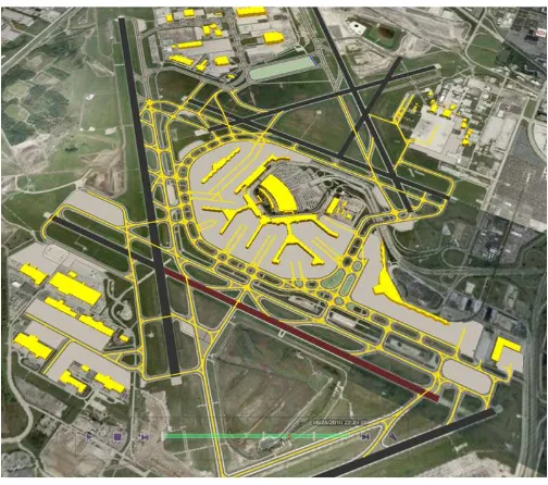
One of our focus points in the project was the visualization of AIXM and WXXM data using the OGC Symbology Encoding (SE) standard. This resulted in a change request for SE which can be considered an absolute necessity to make the use of SE for complex data models feasible. By implementing the proposed changes, we were able to show some promising results. Figure 7 shows an airport layout with runways and aprons respectively styled according to their availability and their contamination condition. Figure 8 shows airspace styling according to the airspace class, corresponding to the ICAO Annex 4 airspace styling guidelines.
Figure 7 – Styling based on availability and contamination type
Figure 9 – Integrated data browser
Figure 10 - 3D visualization