Open Geospatial Consortium
Approval Date: 2013-01-18
Pending Date: 2012-12-21
Publication date: 2013-02-06
Reference number of this document: OGC 12-147
External Identifier for this document:
http://www.opengis.net/def/doc-type/per/OWS-9-Aviation-Architecture
Category: Engineering Report
Editor: Claude Speed
OGC
®OWS-9 Aviation Architecture Engineering Report
Copyright © 2013 Open Geospatial Consortium.
To obtain additional rights of use, visit http://www.opengeospatial.org/legal/.
Warning
This document is not an OGC Standard. This document is an OGC Public
Engineering Report created as a deliverable in an OGC Interoperability Initiative and is not an official position of the OGC membership. It is distributed for review and comment. It is subject to change without notice and may not be referred to as an OGC Standard. Further, any OGC Engineering Report should not be referenced as required or mandatory technology in procurements.
Document type: OGC® Engineering Report
Document subtype: NA
Document stage: Approved for public release
Abstract
This OGC® document describes the architecture implemented in the OWS-9 Aviation thread, including:
A description of the architecture used for the implementation of the OWS-9 Aviation Use Cases.
An overview of the implemented components and workflows followed by a short description of each component.
A discussion about discovery and registry methods and practices.
Documentation of the issues, lessons learned as well as accomplishments and scenarios that were of general interest in the Aviation thread.
More detailed information on specific aspects considered in OWS-9 Aviation may be found in the individual Aviation Engineering Reports.
Keywords
ogcdoc, ows9, ows-9, aviation, architecture
What is OGC Web Services 9 (OWS-9)?
OWS-9 builds on the outcomes of prior OGC interoperability initiatives and is organized around the following threads:
- Aviation: Develop and demonstrate the use of the Aeronautical Information Exchange Model (AIXM) and the Weather Exchange Model (WXXM) in an OGC Web Services environment, focusing on support for several Single European Sky ATM Research (SESAR) project requirements as well as FAA (US Federal Aviation Administration) Aeronautical Information Management (AIM) and Aircraft Access to SWIM (System Wide Information Management) (AAtS) requirements.
- Cross-Community Interoperability (CCI): Build on the CCI work accomplished in OWS–8 by increasing interoperability within communities sharing geospatial data, focusing on semantic mediation, query results delivery, data provenance and quality and Single Point of Entry Global Gazetteer.
- Security and Services Interoperability (SSI): Investigate 5 main activities: Security Management, OGC Geography Markup Language (GML) Encoding Standard
- OWS Innovations: Explore topics that represent either new areas of work for the Consortium (such as GPS and Mobile Applications), a desire for new approaches to existing technologies to solve new challenges (such as the OGC Web Coverage Service (WCS) work), or some combination of the two.
- Compliance & Interoperability Testing & Evaluation (CITE): Develop a suite of compliance test scripts for testing and validation of products with interfaces
implementing the following OGC standards: Web Map Service (WMS) 1.3 Interface Standard, Web Feature Service (WFS) 2.0 Interface Standard, Geography Markup Language (GML) 3.2.1 Encoding Standard, OWS Context 1.0 (candidate encoding standard), Sensor Web Enablement (SWE) standards, Web Coverage Service for Earth Observation (WCS-EO) 1.0 Interface Standard, and TEAM (Test, Evaluation, And Measurement) Engine Capabilities.
License Agreement
Permission is hereby granted by the Open Geospatial Consortium, ("Licensor"), free of charge and subject to the terms set forth below, to any person obtaining a copy of this Intellectual Property and any associated documentation, to deal in the Intellectual Property without restriction (except as set forth below), including without limitation the rights to implement, use, copy, modify, merge, publish, distribute, and/or sublicense copies of the Intellectual Property, and to permit persons to whom the Intellectual Property is furnished to do so, provided that all copyright notices on the intellectual property are retained intact and that each person to whom the Intellectual Property is furnished agrees to the terms of this Agreement.
If you modify the Intellectual Property, all copies of the modified Intellectual Property must include, in addition to the above copyright notice, a notice that the Intellectual Property includes modifications that have not been approved or adopted by LICENSOR.
THIS LICENSE IS A COPYRIGHT LICENSE ONLY, AND DOES NOT CONVEY ANY RIGHTS UNDER ANY PATENTS THAT MAY BE IN FORCE ANYWHERE IN THE WORLD.
THE INTELLECTUAL PROPERTY IS PROVIDED "AS IS", WITHOUT WARRANTY OF ANY KIND, EXPRESS OR IMPLIED, INCLUDING BUT NOT LIMITED TO THE WARRANTIES OF MERCHANTABILITY, FITNESS FOR A PARTICULAR PURPOSE, AND NONINFRINGEMENT OF THIRD PARTY RIGHTS. THE COPYRIGHT HOLDER OR HOLDERS INCLUDED IN THIS NOTICE DO NOT WARRANT THAT THE FUNCTIONS CONTAINED IN THE INTELLECTUAL PROPERTY WILL MEET YOUR REQUIREMENTS OR THAT THE OPERATION OF THE INTELLECTUAL PROPERTY WILL BE
UNINTERRUPTED OR ERROR FREE. ANY USE OF THE INTELLECTUAL PROPERTY SHALL BE MADE ENTIRELY AT THE USER’S OWN RISK. IN NO EVENT SHALL THE COPYRIGHT HOLDER OR ANY CONTRIBUTOR OF
INTELLECTUAL PROPERTY RIGHTS TO THE INTELLECTUAL PROPERTY BE LIABLE FOR ANY CLAIM, OR ANY DIRECT, SPECIAL, INDIRECT OR CONSEQUENTIAL DAMAGES, OR ANY DAMAGES WHATSOEVER RESULTING FROM ANY ALLEGED INFRINGEMENT OR ANY LOSS OF USE, DATA OR PROFITS, WHETHER IN AN ACTION OF CONTRACT, NEGLIGENCE OR UNDER ANY OTHER LEGAL THEORY, ARISING OUT OF OR IN CONNECTION WITH THE IMPLEMENTATION, USE, COMMERCIALIZATION OR PERFORMANCE OF THIS INTELLECTUAL PROPERTY.
This license is effective until terminated. You may terminate it at any time by destroying the Intellectual Property together with all copies in any form. The license will also terminate if you fail to comply with any term or condition of this Agreement. Except as provided in the following sentence, no such termination of this license shall require the termination of any third party end-user sublicense to the Intellectual Property which is in force as of the date of notice of such termination. In addition, should the Intellectual Property, or the operation of the Intellectual Property, infringe, or in LICENSOR’s sole opinion be likely to infringe, any patent, copyright, trademark or other right of a third party, you agree that LICENSOR, in its sole discretion, may terminate this license without any compensation or liability to you, your licensees or any other party. You agree upon termination of any kind to destroy or cause to be destroyed the Intellectual Property together with all copies in any form, whether held by you or by any third party.
Except as contained in this notice, the name of LICENSOR or of any other holder of a copyright in all or part of the Intellectual Property shall not be used in advertising or otherwise to promote the sale, use or other dealings in this Intellectual Property without prior written authorization of LICENSOR or such copyright holder. LICENSOR is and shall at all times be the sole entity that may authorize you or any third party to use certification marks, trademarks or other special designations to indicate compliance with any LICENSOR standards or specifications.
This Agreement is governed by the laws of the Commonwealth of Massachusetts. The application to this Agreement of the United Nations Convention on Contracts for the International Sale of Goods is hereby expressly excluded. In the event any provision of this Agreement shall be deemed unenforceable, void or invalid, such provision shall be modified so as to make it valid and enforceable, and as so modified the entire Agreement shall remain in full force and effect. No decision, action or inaction by LICENSOR shall be construed to be a waiver of any rights or remedies available to it.
Contents
PageExecutive Summary ... 1
1 Introduction ... 1
2 Summary of Accomplishments ... 1
2.1 Web Feature Service ... 2
2.2 Registry Service ... 2
2.3 Event Service ... 2
2.4 Web Processing Service ... 2
2.5 Data Management Service ... 2
2.6 Aviation Client ... 3
3 Observations ... 3
4 Lessons learned ... 4
5 Recommendations ... 5
1 Introduction ... 7
1.1 Scope ... 7
1.2 Document contributor contact points ... 7
1.3 Revision history ... 8
1.4 Future work ... 8
1.4.1 Spatial Filtering of Non-Spatial Features ... 8
1.4.2 Geometry Processing via Web Processing Service ... 9
1.5 Forward ... 9
2 References ... 10
3 Terms and definitions ... 12
4 Abbreviated terms ... 12
5 OWS-9 Aviation Architecture - Overview ... 14
6 Web Services Architecture ... 15
6.1 Workflows ... 15
6.1.1 Data Provision ... 15
6.1.2 Portrayal (ePIB) ... 17
6.1.3 Metadata / Provenance Retrieval ... 19
6.1.4 Data Management Service ... 21
6.2 Component Descriptions ... 24
6.2.1 COMSOFT Web Feature Service ... 24
6.2.2 Snowflake Web Feature Service ... 26
6.2.3 Registry Service ... 29
6.2.5 IfGI Event Service ... 33
6.2.6 Luciad Web Processing Service ... 35
6.2.7 52°North Web Processing Service ... 38
6.2.8 ePIB Client ... 40
6.2.9 ATM-TGS Data Management Service ... 43
6.2.10 Harris Data Management Service ... 46
6.2.11 ATM-TGS Aviation Client ... 50
6.2.12 ATM-TGS Dispatch client ... 51
6.2.13 Luciad Aviation Client ... 52
6.2.14 Deployment characteristics ... 54
7 Data Provision via Web Feature Service and Event Service ... 55
7.1 Overview ... 55
7.2 General Service Architecture ... 55
7.2.1 Web Feature Service ... 56
7.2.2 Event Service ... 56
7.3 Communication Patterns ... 56
7.3.1 Data Model ... 56
7.3.2 Service Chaining ... 57
7.4 Advanced Filtering Functionality ... 58
7.4.1 Stored Queries / Filters ... 59
7.4.2 Simple Altitude Queries ... 61
7.4.3 Spatial Filtering of Non-spatial Features ... 63
7.4.4 AIXM Features as Geometry Operands ... 64
7.4.5 Event Service Update Intervals ... 66
7.4.6 Selective Metadata Retrieval ... 69
7.5 Service Discovery Based on Spatial Extent ... 71
7.6 Accomplishments ... 71
7.7 Lessons Learned ... 71
7.8 Future Work ... 72
8 Geometry Processing via Web Processing Service ... 73
8.1 Overview ... 73
8.2 Applications Profiles ... 73
8.2.1 Intersection Calculation ... 74
8.2.2 Spatial Relation ... 76
8.2.3 Geometry Retrieval ... 77
8.2.4 Limitations ... 81
8.3 Accomplishments ... 81
8.4 Lessons Learned ... 82
8.5 Future Work ... 82
9 FAA SWIM Compliance Analysis ... 83
9.1 Introduction ... 83
9.2 Analysis Process ... 83
9.4 Findings and Observations ... 93
9.4.1 SWIM Requirements ... 94
9.4.2 Observations ... 94
9.5 Summary and Recommendations ... 95
10 Scenario ... 95
10.1 Introduction ... 95
10.2 Component assignments ... 96
10.3 Detailed Scenario ... 97
10.4 Clarifications ... 105
10.5 Aspects Not Covered by Main Scenario ... 106
11 Lessons Learned ... 106
11.1 Inconsistent Data Publication Models ... 106
11.1.1 Problem Statement and Description ... 106
11.1.2 Recommendations ... 107
12 Technical Challenges / Future Work ... 107
13 Accomplishments ... 109
13.1 Web Feature Service ... 109
13.2 Registry Service ... 110
13.3 Event Service ... 110
13.4 Web Processing Service ... 110
13.5 Data Management Service ... 110
13.6 Aviation Client ... 111
Annex A - SWIM Compliance Assessment ... 112
Annex B - Extended Event Service XML Schema ... 123
Annex C - Airspace Geometry Computation ... 128
Annex D – Spatial Relation Process Defintions ... 131
Figures
Figure 1 Common Component Interactions to Retrieve and Disseminate Data 16
Figure 2 ePIB Generation 17
Figure 3 Metadata / Provenance Workflow 21
Figure 4 Data Management Service Workflow – Session Establishment 22
Figure 5 Data Management Service Workflow – Request Response 23
Figure 6 Data Management Service Workflow – Subscription Request / Receive
Notifications 24
Figure 7 Overview of the Snowflake Aviation Component Architecture 27
Figure 9 Update Interval Internals 35
Figure 10 Example of an Intersection Between an AIXM Route and Airspace 36
Figure 11 52°North WPS Three-tier Architecture 39
Figure 12 52°North WPS with ArcGIS Server Backend 40
Figure 13 Example of an ePIB Bitmap Image Generated by the FPS 41
Figure 14 DMS Context Description 44
Figure 15 - Data Provision Service Architecture. 55
Figure 16 - DNOTAM Workflow. 58
Figure 17 – Update Interval Subscription Illustration. 68
Figure 18 – Intersection of Airspace and RouteSegment. 75
Figure 19 – Spatial Relation “Intersects” for Airspace and RouteSegment. 77
Figure 20 SWIM Compliance Assessment Process 84
Figure 21 OWS-9 Operational Scenario 96
Listings
Listing 1 – Taxiway Closure DNOTAM Event. ... 56
Listing 2 – Stored Query Execution. ... 59
Listing 3 – Stored Filter Subscription. ... 60
Listing 4 - Exemplary Altitude Query. ... 62
Listing 5 – Custom XPath Function “extentOf”. ... 64
Listing 6 - Feature by Identifier Reference. ... 65
Listing 7 – Exemplary Geometry Retrieval WPS Request. ... 65
Listing 8 – Update Intervals Capabilities Portion. ... 69
Listing 9 – Example Update Interval Subscription. ... 69
Listing 10 – Example Metadata Exclusion Subscription. ... 70
OGC
®OWS-9 Aviation Architecture Engineering Report
Executive Summary
1 Introduction
The Open Geospatial Consortium (OGC) is engaged in an Interoperability Program which is a global, hands-on and collaborative prototyping program designed for rapid development and delivery of proven candidate specifications into OGC’s Specification Program, which can then be formalized for public release. In OGC’s Interoperability Initiatives, international technology developers and providers team together to solve specific geo-processing interoperability problems posed by the initiative’s sponsoring organizations. OGC Interoperability Initiatives include test beds, pilot projects, interoperability experiments, and interoperability support services – all designed to encourage rapid development, testing, validation and adoption of open, consensus-based standards specifications.
This OGC® document describes the architecture implemented in the OGC Web Services Test Bed 9 (OWS-9) Aviation thread, including:
A description of the architecture used for the implementation of the OWS-9 Aviation Use Cases.
An overview of the implemented components and workflows followed by a short description of each component.
A discussion about discovery and registry methods and practices.
Documentation of the issues and lessons learned as well as accomplishments and scenarios that were of general interest in the Aviation thread.
2 Summary of Accomplishments
2.1 Web Feature Service
Data was loaded, validated, transformed and corrected from multiple sources This effort included splitting the data into two Web Feature Service (WFS) instances, one for North American data and one for Middle-Northern Europe data
Calculation of airspace extents in full 2.5D, including composite airspaces (unions, intersections and subtractions), support for altitude queries including calculation of extents of non-spatial feature types (runways, taxiways and aprons), and support for spatial filtering of non-spatial feature types.
2.2 Registry Service
The OWS-9 Aviation Registry was used to host resources shared between multiple OGC services (e.g. ISO metadata pertaining to datasets common to multiple Web Feature Service implementations, styling information shared between multiple Feature Portrayal Service implementations, and ISO Service metadata describing the Services deployed in OWS-9. The efficient retrieval of metadata task was also implemented using the Aviation Registry by designing queries to retrieve only the relevant excerpts of the metadata desired by clients.
2.3 Event Service
Compared to the Event Services (ES) used in the previous OGC test beds, major
improvements were been implemented during OWS-9, particularly features summarized under the term “Advanced filtering functionality.” These included “Event Service Update Intervals”, “Stored Filters”, “AIXM Features as Geometry Operands”, “Spatial Filtering of Non-spatial Features”, “Simple Altitude Queries” as well as “Selective Metadata Retrieval”.
2.4 Web Processing Service
Web Processing Service profiles were implemented to support Electronic Pre-Flight Information Briefing (ePIB) generation and geometry processing, including calculation of topological relations between two AIXM 5.1 features in ellipsoidal space. Supported topological relations included INTERSECTS, DISJOINT, EQUALS, TOUCHES, CROSSES, OVERLAPS, CONTAINS, WITHIN, COVERS, COVERED_BY.
2.5 Data Management Service
OWS-9 introduced a Data Management Service (DMS) which included a set of
DMS service discovery which included the process of finding and setting the processing options used by the DMS to manage communications between the aircraft and dispatch client.
DMS basic pass-through which handled the forwarding of request/response and notifications between the aircraft client and OGC web services.
Reliable messaging.
Data compression and expansion.
Data filtering.
Dispatch synchronization.
2.6 Aviation Client
Aviation clients were implemented and tested that provided map-centric displays with intuitive user interface giving access to data from entities such as WFS, ES, and the DMS. The continuing evolution of these clients provided a rich set of capabilities and features that helped to demonstrate the OWS-9 Aviation scenario and to perform testing and integration with a wide variety of service components.
3 Observations
This test bed presented a number of challenges ranging from inconsistencies among data publishers to calculation of intersecting geometries that provided opportunities for advancing the state of interoperability for the international community.
Data Management Service - This test bed interjected a new concept into the OGC environment – a value-added proxy between a client and the web services that serve it. Inspired by the Federal Aviation Administration Aircraft Access to System-Wide Information Management (SWIM) project, this initiative explored the efficacy of using proxies to manage many of the tasks required to connect an airborne client to multiple Air Navigation Service Provider (ANSP) data
publishers.
Inconsistent Data Publication Models - As OGC standards, such as AIXM 5.1, are being increasing deployed in operational production environments by data
Calculation of the airspace extent in 2.5D - The correct calculation of composite airspaces, which in turn may be composed of other airspaces and which may in turn include references to geographical borders, in conjunction with taking the vertical dimension into account turned out to be a challenging task that will require continuing work to resolve.
Feature Portrayal Service Performance - One important and reoccurring challenge when working with a Feature Portrayal Service (FPS) in general is to get optimal performance. The high flexibility of being able to submit any kind of feature data and styling information comes with difficulties to achieve this. The AIXM format is verbose, so large amounts of bandwidth can be needed to provide the FPS with the necessary feature data. While not a particular problem in a test bed
environment with limited data throughput requirements, as international
production implementations grow it will increasingly become an issue that needs to be resolved.
4 Lessons learned
Common Definition of WPS Process Definitions - When designing a WPS
ProcessDefinition, the format for inputs and outputs can be defined by pointing to a commonly available XML Schema. By implication, a WPS implementing such ProcessDefinition must support all available root elements as inputs/outputs. To enable true interoperability among different WPS instances, one needs to be as exact as possible defining the inputs/outputs.
Interoperability among ANSPs – One of the important lessons learned in the development of the DMS was creating a solution that could fully communicate with both the North American and European SWIM environments. Although the overarching system concepts for SWIM are the same in both North American and Europe, the actual SWIM implementations currently employ different technical standards for their communication interfaces. Resolution or harmonization of these standards will be required for truly interoperable technical solutions for communications with both SWIMs.
Conclusions
1. One approach would be to establish governance processes for identifying data that is common and critical to proper functioning of the services and then managing its application. This governance could consist of:
Developing a set of rules for defining who was the definitive authority for assigning a feature its UUID. Ideally this should be the entity that is responsible for creating and maintaining the data as the most knowledgeable about the data capture and lifecycle maintenance rules). Once a UUID is assigned, it could be persisted throughout the data exchange system and no third party should change it once supplied.
Developing a process for determining when a service was not following the rules. 2. Conformance testing – OWS-9 participants are building and/or testing Compliance
and Interoperability Test (CITE) reference implementations for the following services:
SPS 2.0.
WMS 1.3 client and server.
WFS 2.0.
WFS EO 1.0.
As these components are tested, validated, and incorporated into implementation integration testing, it will be easier to check that a service really supports a certain set of functionality. Then the required set of functionality can be stated more precisely in procurement requirements and service providers will be better able to prove up-front which functionality they support. In conjunction with an active governance and certification process, the variations in standards interpretations can be minimized with improved interoperability as the result.
5 Recommendations
The evolution of the business needs that drive technical standards continually requires the technical community to make choices about customization and tailored applications that manipulate data flowing from a standards-based web service. While these efforts satisfy customer requirements, they tend to create intrinsic incompatibilities when the data is stored in a standards-based data model and then redistributed. The challenge for standards bodies such as the OGC is to guide the standards working groups into creatively resolving incompatibilities among implementations without making the standard more complex than absolutely necessary. Following this theme, it is recommended that OGC expand and formalize its initiatives designed to reduce the number of standards interpretation incompatibility issues, such as:
3. Conformance testing - OWS-9 participants are building and/or testing Compliance and Interoperability Test (CITE) reference implementations for the following services:
SPS 2.0
WMS 1.3 client and server
WFS EO 1.0.
As these components are tested, validated, and incorporated into implementation integration testing, it will be easier to determine whether a service really supports a certain set of functionality. Then the required set of functionality can be stated more precisely in procurement requirements and service providers will be better able to prove up-front which functionality they support.
OGC
®OWS-9 Aviation Architecture Engineering Report
1 Introduction
1.1 Scope
This OGC® document describes the architecture implemented in the OWS-9 Aviation thread, including:
A description of the architecture used for the implementation of the OWS-9 Aviation Use Cases.
An overview of the implemented components and workflows followed by a short description of each component.
A discussion about discovery and registry methods and practices.
Documentation of the issues, lessons learned as well as accomplishments and scenarios that were of general interest in the Aviation thread.
More detailed information on specific aspects considered in OWS-9 Aviation may be found in the individual Aviation Engineering Reports.
1.2 Document contributor contact points
All questions regarding this document should be directed to the editor or the contributors:
Name Organization
Daniel Balog Luciad Roger Brackin Envitia David Burggraf Galdos Thibault Dacla ATM-TGS
Hoang Dam IDS
Johannes Echterhoff IGSI
Robin Houtmeyers Luciad
Matthes Reike 520North / IfGI Claude Speed SpeedSquared
Timo Thomas COMSOFT
Debbie Wilson Snowflake Software Stuart Wilson Harris
1.3 Revision history
Date Release Editor Primary clauses modified
Description 12/2/201
2
0.1 Speed All Incorporation of component descriptions and incorporated ERs 12/4/201
2
0.2 Speed Executive Summary
Incorporation of an Executive Summary and minor edits 12/21/20
12
1.0 Speed All Final edit
1.4 Future work
Future work to advance the state of OGC standards, their implementation, and interoperability is addressed in this section.
1.4.1 Spatial Filtering of Non-Spatial Features
into the XPath function to define the use case / interpretation. This will enable a client to retrieve different representations for specific tasks.
When subscribing for an update interval, client software should be able to define if it is interested in receiving all messages or only the latest event for the specified time window. The capability of a service to detect different features (e.g. two different Airports) within a time window should be specified in the service capabilities and is proposed for future work.
1.4.2 Geometry Processing via Web Processing Service
A WPS geometry retrieval profile can be used to resolve the geometry from an AIXM feature. One specialty of AIXM is that airspaces contain surfaces (AirspaceVolumes) that can be formed using geometric operations (difference, union, intersection). The WPS server is able to return a set of disjoint GML surfaces that represent the original airspace. Additionally, airspaces contain altitude data. This is currently not modeled by GML. Proposed future work includes:
Altitude modeling – Proposed future work is to create a custom GML schema that explicitly models the altitude to enable WPS profiles to integrate altitude calculations into geometry intersection calculations.
2.5D and 3D calculations – Current implementations of the WPS only support the horizontal extent of AIXM features. One future work item should focus on the integration of the vertical extent to determine whether a general approach for transforming AIXM 2.5D geometries into GML 3D geometries should be developed.
Additional WPS Profiles – Proposed future work includes development of additional profiles calculate actual altitudes (e.g. based on barometric pressure, DEMs), calculate the containing circle for an Airspace border (used for a Digital NOTAM’s Q line), and metadata/provenance resolution.
1.5 Forward
Attention is drawn to the possibility that some of the elements of this document may be the subject of patent rights. The Open Geospatial Consortium shall not be held
responsible for identifying any or all such patent rights.
2 References
The following documents are referenced in this document. For dated references, subsequent amendments to, or revisions of, any of these publications do not apply. For undated references, the latest edition of the normative document referred to applies. OWS-9 Engineering Reports:
[OGC 12-094] OWS-9 AIRM to WXXM Derivation Engineering Report.
[OGC 12-144] OWS-9 Aviation Registry Engineering Report.
[OGC 12-145] OWS-9 Aviation Metadata and Provenance Engineering Report.
[OGC 12-146] OWS-9 Web Feature Service Temporality Extension Engineering Report.
[OGC 12-151] OWS-9 Aviation Portrayal Engineering Report.
[OGC 12-158] OWS-9 Aviation Performance Study Engineering Report.
[OGC 12-163] OWS-9 Data Transmission (to Aircraft) Management Engineering Report.
Other OGC Documents:
OGC 05-007r7, OpenGIS Web Processing Service 1.0.0.
OGC 06-121r3, OGC® Web Services Common Standard.
OGC 07-110r3, OGC® CSW-ebRIM Registry Service - Part 1: ebRIM profile of CSW.
OGC 07-144r3 OGC® CSW-ebRIM Registry Service - Part 2: Basic extension package.
OGC 08-133, OpenGIS Sensor Event Service Interface Specification Discussion Paper.
OGC 09-025r1, OpenGIS Web Feature Service 2.0 Interface Standard.
OGC 09-026r1 , OpenGIS Filter Encoding 2.0 Encoding Standard. Aviation Documents:
Generation, online at http://www.aixm.aero/public/standard_page/download.html.
AIXM - AIXM Application Schema Generation, online at
http://www.aixm.aero/public/standard_page/download.html .
AIXM - Temporality Model v1.0, online at
http://www.aixm.aero/public/standard_page/download.html .
AIXM - Temporality Model v1.0, online at
http://www.aixm.aero/public/standard_page/download.html .
AIXM - UML to XML Schema Mapping v1.1, online at http://www.aixm .
AIXM - UML to XML Schema Mapping v1.1, online at
http://www.aixm.aero/public/standard_page/download.html.
Digital NOTAM Event Specification, ed. 1.0 (Proposed Release), online at
http://www.aixm.aero/public/standard_page/digital_notam_specifications.html . Other Documents:
AIRM-ISRM Requirements (08.03.02.D04).
OASIS Web Services Reliable Messaging (WS--‐Reliable Messaging) Version1.2, http://docs.oasis--‐open.org/ws--‐rx/wsrm/200702.
OASIS WS-BaseNotification Standard , Web Services Base Notification 1.3.
Operational Service and Environment Definition (OSED Step 1) (13.02.02.D01).
SESAR Demonstrator Report (08.03.02.D08).
SWIM Registry Concept of Operations V1 (08.03.02.D03).
SWIM Service Compliance Requirements -
http://www.faa.gov/about/office_org/headquarters_offices/ato/service_units/techo ps/atc_comms_services/swim/documentation/media/compliancy/SWIM%20Servi ce%20Compliance%20Requirements.pdf.
Systems Rules Model (SRM) – see [OGC 12-163] OWS-9 Data Transmission (to Aircraft) Management Engineering Report.
The Unified Code for Units of Measure (UCUM), online at
http://aurora.regenstrief.org/~ucum/ucum.html.
W3C XML Information Set (second edition)
http://www.w3.org/TR/xml--‐infoset/.
3 Terms and definitions
For the purposes of this report, the definitions specified in Clause 4 of the OWS Common Implementation Standard [OGC 06-121r3] apply.
4 Abbreviated terms
2D Two dimensional
2.5D Two and a half dimensional (3/4 perspective)
3D Three dimensional
AIP Aeronautical Information Publication AIM Aeronautical Information Manual
AIXM Aeronautical Information Exchange Model AMDB Airport Mapping Database
AOC Airline Operational Communication ATM Air Traffic Management
CCI Cross Community Interoperability CDMS Client DMS module
COTS Commercial Off The Shelf
CSW OGC Catalogue Service for the Web DEM Digital Elevation Model
DMS Data Management Service DNOTAM Digital NOTAM
DS-client Dispatch synchronization client E-DMS Europe Data Management Service E-ES Europe Event Service
E-WFS Europe WFS
EAD European Organisation for the Safety of Air Navigation EANS Estonian Air Navigation Services
ePIB Electronic Pre-flight Information Briefing
ES Event Service
ESA European Space Agency
FAA Federal Aviation Administration FES Filter Encoding Specification FI/FIS FastInfoSet
FPS Feature Portrayal Service GML Geography Markup Language GP-WFS Geometry Processing WFS
GZIP GNU ZIP
HTTP HyperText Transfer Protocol IP Internet Protocol
ISO International Standards Organization METAR A format for reporting weather information N-client NOTAM generation client
NA-DMS North American Data Management Service NA-ES North American Event Service
NA-WFS North American WFS
NASR National Airspace System Resources NOTAM Notice To Airmen
OASIS Organization for the Advancement of Structured Information Standards OGC Open Geospatial Consortium
OWS OGC Web Service
OWS-9 OGC Web Services (OWS), phase 9
PDP Policy Decision Point (typically in a XACML framework) PEP Policy Enforcement Point (typically in a XACML framework) QoS Quality of Service
QName Qualified Name
SAA Special Activity Airspace
SE Symbology Encoding
SESAR Single European Sky ATM Research Programme SLD Styled Layer Descriptor
SWIM System-Wide Information Management TAF Terminal Area Forecast
TCP Transmission Control Protocol URL Uniform Resource Locator URN Uniform Resource Name WCS Web Coverage Service WFS Web Feature Service WFS-T WFS Transactional
WMS Web Map Service
WPS Web Processing Service
WSDL Web Services Description Language WS-N OASIS Web Services Notification WXXM Weather Information Exchange Model XACML Extensible Access Control Markup Language XML Extensible Markup Language
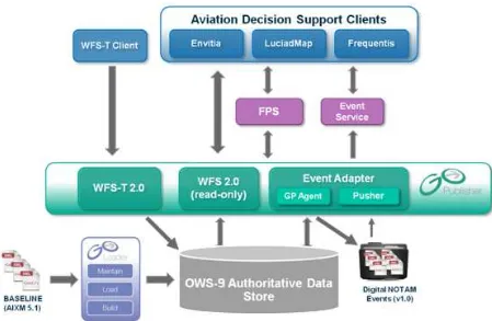
5 OWS-9 Aviation Architecture - Overview
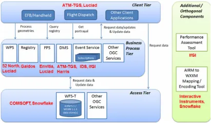
The OWS-9 Aviation thread architecture can be separated into three tiers (see Figure 1):
The Client Tier contains the client applications.
The Business Process Tier contains components that offer services on top of the Access Tier: Web Processing Service, Registry, Feature Processing Service, Data Management Service, and Event Service.
The Access Tier contains Web Feature Services serving AIXM 5.1 data as well as Weather Information Exchange Model (WXXM) 1.1.3 and other data.
Figure 1 — OWS-9 Aviation Architecture – High-Level Overview
Figure 1 shows the links between the tiers and the general functionality that is invoked. It also shows which participants provided which components. A summary description of the components is provided in chapter 7.
6 Web Services Architecture
6.1 Workflows
This section provides a high-level overview of the common interactions between client and service components in the OWS-9 Aviation service infrastructure.
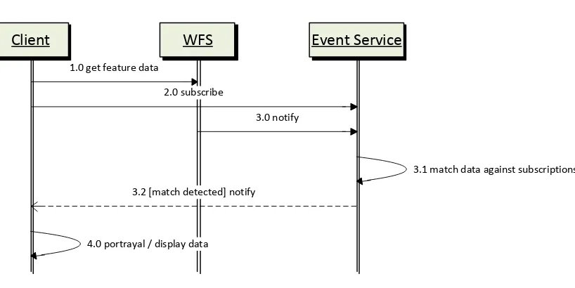
6.1.1 Data Provision
Client WFS Event Service
1.0 get feature data
2.0 subscribe
3.0 notify
3.1 match data against subscriptions
3.2 [match detected] notify
4.0 portrayal / display data
Figure 1 Common Component Interactions to Retrieve and Disseminate Data The following paragraphs describe the interactions shown Figure 1.
1.0: The client retrieves feature data from the Web Feature Service (WFS) (e.g. via the GetFeature operation). The client can request general information, for example, on airspaces and airports. Using specific filter criteria, it can also query the WFS to identify suitable alternate/diversion airports (e.g. by searching for airports that have a passenger terminal, re-fueling facilities, a hard-surface runway of certain required minimum length, etc.). Weather data formatted as METARs and Terminal Area Forecasts (TAFs) can also be served by and requested from a WFS.
2.0: The client creates a subscription at an Event Service (ES) to automatically be notified whenever the Event Service receives new data that matches the subscriptions filter criteria. For example, the subscription can be used to receive Digital Notices to Airmen (DNOTAMs) for airports (e.g. the destination and alternates, airspaces, and airspace activations). In this step, only the subscription is created and the interaction ends. The actual publishing of new data is described in Step 3.0.
3.0: Whenever a WFS detects a relevant change in its feature data (for example that an airspace got a new activation or that a runway was closed), it generates a notification that represents the change (for example encoded as a DNOTAM) and sends it to the Event Service.
3.2: If the data matches a given subscription, then the Event Service notifies the recipient defined for the subscription (here it is the client).
4.0: The client processes the data that it either retrieved from a WFS or received from an Event Service and usually portrays it according to some style.
6.1.2 Portrayal (ePIB)
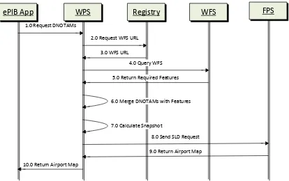
The following sequence diagram shows common interactions for retrieving data and merging it with airport data to enable generation of the Electronic Pilot Information Briefing (ePIB) document.
ePIB App WPS Registry
1.0 Request DNOTAMs
2.0 Request WFS URL 3.0 WFS URL
WFS FPS
4.0 Query WFS 5.0 Return Required Features
8.0 Send SLD Request 7.0 Calculate Snapshot
6.0 Merge DNOTAMs with Features
9.0 Return Airport Map 10.0 Return Airport Map
Figure 2 ePIB Generation
The following paragraphs describe the interactions shown in Figure 2.
1. The ePIB component sends the airport map request to the Web Processing Service (WPS), consisting of an airport (GML) identifier and a list of Digital NOTAMs. The Digital NOTAMs are encoded according to the Digital NOTAM Event Specification. 2. The WPS needs features to enrich the Digital NOTAM dataset, and relies on the
feature types. For instance, retrieve the WFS that can deliver the Navaid feature with this Geography Markup Language (GML) identifier, or retrieve the WFS that can deliver Runway features for the airport with a given GML identifier. The following features are considered necessary:
Features relevant for the airport layout. All features related to the airport layout (i.e., runways, taxiways, aprons ...) are needed for the resulting airport map. For this, a WFS request is sent to query airport layout features (e.g. a hardcoded set of feature types) for the specified airport.
Features impacted by the Digital NOTAMs. Each Digital NOTAM is analysed: if it concerns an airport layout feature (e.g. a TaxiwayElement, RunwayElement, VerticalStructure) that was already retrieved in 2.1, the corresponding feature representation on the map is updated / overlaid with the information coming from the Digital NOTAM.; if it concerns a feature that is not yet part of the airport layout (e.g. the Digital NOTAM is about the unavailability of an ILS Navaid) which is not part of the standard airport layout, then this feature needs to be retrieved from a WFS and its graphical "temporary status" situation is overlaid on the map.
3. The Registry Service returns the URL(s) of the WFS components that can deliver the required features.
4. The WFS is contacted to retrieve the requested features. 5. The WFS returns the required features.
6. The WPS now has a set of AIXM 5.1 features retrieved from the WFS (BASELINE timeslices but potentially also TEMPDELTAs/PERMDELTAs) and a set of Digital NOTAM features (essentially TEMPDELTA timeslices). This data is merged to obtain one coherent AIXM 5.1 feature collection that serves as a basis for the airport map.
7. The AIXM 5.1 feature collection still contains multiple timeslices for each feature, valid for various time intervals. To avoid timeslice calculations in the FPS, the WPS calculates a snapshot for the AIXM 5.1 feature collection. The snapshot date could be determined by inspecting the Digital NOTAMs.
8. The WPS constructs a Styled Layer Descriptor (SLD) request with a user layer embedded with the snapshot features and sends it to the FPS.
In this design, the WPS is the central component to manage the airport map generation and contains all the business logic. An advantage is that the WFS and FPS components remain general and do not require any modification that is the specific for the ePIB setup.
6.1.3 Metadata / Provenance Retrieval
Dataset Metadata can be defined as data about a dataset. One class of metadata of particular interest in OWS-9 Aviation is data provenance (or lineage), which records the salient characteristics of the evolution of shared datasets, typically due to quality
additions or enhancements by different users. The creation of such metadata is meant to tell a potential data user about its quality, whether it is fit for purpose, and provide guidance on its use and re-use. The value of metadata increases exponentially with the number of different responsible parties involved in sharing and updating information resources in distributed data environments. In the metadata creation, discovery, access, and management sub-tasks of the OWS-9 Aviation thread, we implemented an
aviation/weather metadata profile of ISO 19139 and tested its handling and processing by a community of users of OWS-9 software services. The common metadata (e.g. license terms) about aviation datasets (AIXM/WXXM) and services published by authorized distributors was used to discover and access shared resources (e.g. data, services, styling information) and answer the following questions:
Who was the creator/publisher?
Who has permission to use the resources and what are the terms?
When was the data last modified? How was the data transformed?
Where can it be accessed? How can it be processed and by which services?
Which applications, software configuration or tool’s settings were used to process the data?
Six distinguished categories of metadata are summarized as follows:
1. Lineage/provenance - identifies the original sources from which the data was derived and details the processing steps through which the data has gone to reach its current form. The traceability of the data can help determine its accuracy and relevance tasks by different users.
2. Quality - determine fitness for use, conformance to design specifications and fulfillment of requirements of a coordinated effort.
3. Accuracy - degree of correspondence between data and the real world depending on the quality and precision of the instruments used to capture the data.
5. Precision - represents the exactness of measurement (or description) and is determined by the input. Data can always be output at lower, but not higher, resolution.
6. Scale - is the ratio of distance on a map to the equivalent distance on the Earth’s surface
Based on the assumption that the proposed Data_Quality extension to the CIM model is adopted, there are several steps involved in publishing provenance data. More detailed information on the proposed Data_Quality extension can be found in 07-038 OGC Cataloging of ISO Metadata CIM Using the ebRim Profile of CS-W discussion paper. Different components of the model must be published by different actors, as shown in the sequence diagram in Figure 3. In OWS-9, the Data Management Service (DMS) was a primary user of the metadata / provenance workflow. The sets of activities involved in this workflow are summarized below the Figure.
WFS Stakeholder DMS
1.0 Register via Harvest Method
4.0 FindDataSet
7.0 Publish Provenance
Registry
8.0 Query Provenance
2.0 Publish Service Info
9.0 Format Results 3.0 FindWFS
WFS Registration Process
DMS Service Registration
DMS Processing Declaration
DMS Processing Event
5.0 Publish Source Declaration 6.0 Source Identifier
10.0 Provenance Data
Figure 3 Metadata / Provenance Workflow
1. WFS Registration Process - DataMetadata was published along with DataQuality and Lineage objects using CSW-ebRIM with CIM model.
2. DMS Service Registration - This is a one-time step to publish service identification information (e.g. Organization object).
3. DMS Processing Declaration - For each DMS processing option, the DMS declared its intent to capture provenance for a given WFS/Dataset pair by publishing a Source object describing DMS option (e.g. filtering approach) and associating it to the Lineage object for the selected WFS.
4. DMS Processing Event - For each DMS request processed, provenance details were published to a ProcessSetp instance related to the appropriate DMS Source entry specified by identifier.
5. Stakeholder Review/Browse Provenance - Stakeholders had the capability of querying provenance data in a variety of ways using OGC Filter queries. The Registry formatted the results if response content needed to be something other than XML.
6.1.4 Data Management Service
6.1.4.1 Session Establishment
The workflow illustrated in Figure 4 describes how the Client performed a handshaking protocol with DMS to select reliable messaging option, compression algorithm to use, and configuration options for data validation and filtering. The DMS created a unique consumer reference for the Client to ensure that the right data was delivered to the right client and to manage subscriptions. The Client contacted the DMS to request a listing of available DMS modules. The DMS responded and the Client selected the modules it wanted to use (e.g. reliable messaging, compression algorithm, validation, and filtering configuration options).
Client
DMS
1.0 Request for List of Available DMS Modules
2.0 List of available modules
3.0 Reliable messaging option selection
4.0 Compression Algorithm Selection
5.0 Data Validation Configuration Options
6.0 Filtering Configuration Options
7.0 Create Unique Consumer Reference
6.1.4.2 Request-Response
The workflow illustrated in Figure 5 describes the process used by the Client to request data from an OGC Web Service (OWS). The Client sent the request to the DMS
including an OWS endpoint and the DMS forwarded the request to the appropriate OWS. Upon receipt of the data from the OWS, the DMS performed data validation, filtering, and prioritization in accordance with its re-configured set of technical rules. This processed data was sent to the Client and a copy or summary was sent to the Dispatcher.
Client DMS OWS Dispatcher
8.0 Data Request (with OWS endpoint)
9.0 Data Request
10.0 Requested Data
11.0 Perform Data Validation
12.0 Perform Filtering
13.0 Perform Prioritization
14.0 Processed Data
14.0 Data Copy or Summary
The workflow illustrated in Figure 6 describes the process used by the Client to request a subscription from an Event Service (ES). The Client sends the subscription request to the DMS including an ES endpoint and the DMS forwards the request to the appropriate ES. Upon receipt of the data updates or notifications from the ES, the DMS maps the update interval (if required) to the consumer reference to verify that update interval
specifications are being satisfied. Additionally, the DMS performed data validation, filtering, and prioritization in accordance with its re-configured set of technical rules. This processed data was sent to the Client and a copy or summary was sent to the Dispatcher.
Client DMS ES Dispatcher
15.0 Subscription Request (with ES endpoint)
16.0 Subscription Request 17.0 Data Updates / Notifications
18.0 Map Update Interval to Consumer Reference
19.0 Verify Update Intervals
23.0 Processed Data
24.0 Data Copy or Summary 20.0 Perform Data Validation
21.0 Perform Filtering
22.0 Perform Prioritization
Figure 6 Data Management Service Workflow – Subscription Request / Receive Notifications 6.2 Component Descriptions
6.2.1 COMSOFT Web Feature Service
6.2.1.1 Overview
COMSOFT’s Aeronautical Information Management Database (CADAS-AIMDB) is a
components such as electronic Aeronautical Information Publication (AIP), Charting, NOTAM Office, or Briefing with a central Aeronautical Database.
A design principle is the interoperability with other systems. As the database is the core of any integrated Aeronautical Information Manual (AIM) solution, an open interface that can be used independently from any platform and programming language is one of the key features. For an optimal support of AIXM 5 CADAS-AIMDB provides the CAW-interface. In OWS-9, an extension to the WFS 2.0 specification was developed and implemented for better support for dynamic feature data such as AIXM 5.
6.2.1.2 Purpose in OWS-9
In OWS-9, the CADAS-AIMDB was used as a WFS data store and DNOTAM event source. As a WFS data store, it hosts static (BASELINE and PERMDELTA time slices) and dynamic data (TEMPDELTA time slices). Time slices can be retrieved from and stored to the WFS. The retrieval operations support complex filters built of logical, spatial, temporal and comparison operators.
When TEMPDELTA time slices are inserted, corresponding DNOTAM events are created and sent to registered Event Services by a Web Service message.
6.2.1.3 Accomplishments
Several accomplishments in different work areas were achieved.
Data loading and service deployment
o Data loaded, validated, transformed and corrected from various sources:
Productive European Organisation for the Safety of Air Navigation (EAD) AIXM 4.5 data, mapped by the COMSOFT AIXM 4.5 to 5.1 Mapper to AIXM 5.1 data (North America and Middle-Northern Europe).
OWS-9 simulated airport, DONLON, data set, corrected according to AIXM schema and temporality model and enriched with metadata
US ePIB data set, General Mitchell International Airport and Bradley International Airport, corrected according to temporality model and enriched with metadata
o Deployment of two WFS instances, one for North American data and one for Middle-Northern Europe data.
Implementation
o Calculation of airspace extents in full 2.5D and time, including composite airspaces (unions, intersections and subtractions) and airspace parts based on borders (references to GeoBorder features).
o Support for altitude queries on airspaces
o Calculation of extents of non-spatial feature types (runways, taxiways and aprons) and support for spatial filtering of non-spatial feature types.
o Support for AIXM features as geometry operands by feature reference.
o Support for the WFS Temporality Extension.
o Support for selective metadata retrieval.
Conceptual Work
o Improving and finalizing the WFS Temporality Extension OGC Discussion Paper, incorporating feedback from other participants.
o Specification of altitude queries, of using AIXM features as geometry operands and of selective metadata retrieval.
6.2.1.4 Challenges
A key challenge was the airspace extent calculation in 2.5D. The correct calculation of composite airspaces, which in turn may be composed of other airspaces and which may in turn include references to geographical borders, turned out to be a challenging task, especially when taking the vertical dimension into account. As the specification is a mixture of AIXM and GML, a dedicated algorithm had to be developed, combining 2D calculations on the earth’s ellipsoid with AIXM specific properties for the vertical extent and composition operators.
6.2.2 Snowflake Web Feature Service
6.2.2.1 Overview
Figure 7 Overview of the Snowflake Aviation Component Architecture Aeronautical data was received from a range of sources and integrated into two consolidated AIXM 5.1 databases representing North American and European data sources. The Snowflake Software component architecture consisted of three components.
6.2.2.1.1 WFS 2.0 (read-only)
Two different instances of the read-only WFS 2.0 were established to represent United States and European data sources. These WFS instances were configured so that each feature contained only one timeslice. Thus multiple features were published that represented the real world objects.
European WFS.
United States WFS.
6.2.2.1.2 WFS-T 2.0 (transactional)
WFS-T.
European WFS (T).
United States WFS (T).
6.2.2.1.3 Event Publisher
The Event Publisher is composed of two components:
GO Publisher Agent: a server-side bulk data publishing system that generates event messages.
Event Pusher: registers with one or more event services as an event source and pushes the messages generated to the event service brokers.
Publication of Events is triggered by the insertion of a feature into the database via a WFS-T insert transaction. The GO Publisher Agent generates a Digital NOTAM Event and transfers it to an Event pusher which forwards the message to the Event Services.
6.2.2.2 Component functionality
No new component functionality was developed for either GO Publisher WFS or the Event Publisher during OWS-9. GO Publisher WFS currently implements a large proportion of the OGC WFS 2.0 specification and the Event Publisher continues to have sufficient functionality to connect to the IfGI and IDS Event Services.
Within OWS-9, the aim was to further evaluate the effectiveness of the basic mandatory WFS 2.0 operations and full filter encoding (FE 2.0) to retrieve AIXM 5.1 data for the various flight planning and dispatch scenarios identified.
6.2.2.3 Data available via the Components
The OWS-9 consolidated database consisted of AIXM data from the following sources:
Eurocontrol EAD data (North America and Europe).
Comsoft EAD data (North America, Canada and Middle Europe).
Comsoft Estonian Air Navigation Services (EANS) - Estonia data (Europe).
FAA Airport Mapping Database (AMDB) data from OWS-8.
FAA Chicago National Airspace System Resources (NASR) data.
6.2.2.4 Accomplishments
Several key accomplishments were developed for OWS-9 within the data maintenance and publication architecture developed by Snowflake:
Data was consolidated from multiple sources and published using different AIXM 5.1 extension schemas into a single authoritative database. Access to these data was provided via the WFS 2.0 and Event Publisher.
The data was split spatially into North America and Europe sources for the WFS.
The WFS-T was configured to allow events to be inserted into the database. On insertion additional processes for publication were activated via Event Publisher and WFS.
6.2.2.5 Challenges
Key challenges were identified when loading the AIXM source data. 1. Features without spatial property
There were a number of features types which do not contain a geometry property. It was thus difficult to separate these feature types into a North American and European service.
2. Deeply nested Airspace by reference geometry elements
The source data for the Airspace feature type contain geometries with reference to geometry elements in other features which in turn could contain references to yet more features. This nesting of geometry references could be several levels deep and proved too time consuming to sort out within the scope of the OWS9 project.
3. Issues with the source data
There were a number of issues with the source data geometry. For example Circle-by-Centre-point geometries with a zero radius value and Arc-Circle-by-Centre-point geometries with a missing radius. Primarily, but not exclusively, this occurred within the Airspace feature type.
6.2.3 Registry Service
and the ebRIM profile applies a flexible registry information model to supplement the common interface (Get, Insert, Update, Delete Records, etc).
The OWS-9 Aviation Registry was used to host resources shared between multiple OGC services (e.g. ISO metadata pertaining to datasets common to multiple WFS
implementations (Snowflake, Comsoft), Styling information shared between multiple Feature Portrayal Services (FPS) implementations (Envitia, Luciad), and ISO Service metadata describing the Services deployed in OWS-9). The efficient retrieval of metadata task was also implemented using the Aviation Registry by designing queries to retrieve only the relevant excerpts of the metadata desired by clients. The participants used Insert/Update/Get transactions to create User accounts, publish common resources, and efficiently retrieve resources using complex filtered queries. No functional or
performance issues were encountered during the OWS-9 initiative.
Unlike conventional geographic catalogues, INdicio™ is highly configurable and can be readily deployed to manage a wide variety of objects.
INdicio™ ships with a CSW-ebRIM Basic Extension Package which provides a variety of useful objects for geospatial applications including:
Service taxonomy and Dataset metadata model (source: ISO 19115/19119/19139) via the preloaded OGC Cataloging ISO Metadata (CIM) Registry Information Model.
Feature data dictionaries and catalogues (source: ISO 19109/19110/19126).
Coordinate Reference Systems (source: ISO 19111).
Country codes (source: ISO 3166-1 “Codes for the representation of names of countries and their subdivisions – Part 1: Country codes”).
Geographical regions (source: UN Statistics Division).
Property categories based on Dublin Core (source: DCMI metadata terms).
6.2.4 IDS Event Service
IDS provided one of the two ES implementations of the broker component which is based on the Organization for the Advancement of Structured Information Standards (OASIS) Web Services Brokered Notification 1.3 specification. Its main functionalities included finding a match between a notification sent by a producer and subscriptions subscribed by a consumer, then disseminating those matching records to that consumer. The IDS ES has been used since OWS-8.
6.2.4.1 Interfaces
The IDS ES consists of five endpoints, and their descriptions can be found at:
Endpoint Available Methods URL NotificationBroker Notify, Subscribe,
CreateStoreFilter, ListStoredFilters,
DescribedStoreFilters and GetCurrentMessage
http://vpn.ubitech.com:9998/IdsBrokerInt erface/IdsBroker
PauseableSubscription Manager
Unsubscribe, PauseSubscription, ResumeSubscription and Renew
http://vpn.ubitech.com:9998/IdsBrokerInt erface/IdsPausableSubscriptionManager
Users can access the service WSDL by concatenating the “?wsdl” at the end of the service endpoint (e.g. http://vpn.ubitech.com:9998/IdsBrokerInterface/IdsBroker).
All available methods are defined by OASIS Web Services Notification (WS-N), with the exception that all stored filter methods are extended and described in an experimental schema (http://test.schemas.opengis.net/ows-9/aviation/es/storedFilters.xsd). The methods used in this test bed are described in the following table.
Method Description
Notify Used by a producer to push a NotificationMessage to the ES. The contents are Digital NOTAM Events or position update messages of an aircraft.
Subscribe Used by a consumer to define a subset of all incoming notifications. A subset can be defined using topic filters, XPath expressions and FES 1.1/2.0 filters.. A Subscription can have an InitialTerminationTime (encoded as a period or a date time) to define its lifetime.
Unsubscribe Used by a client to cancel a subscription. CreateStoredFilter Used by a client to create a stored filter.
ListStoredFilters Used by a client to discover the availability of all stored filters have been created.
DescribedStoredFilters Used by a client to retrieve stored filter descriptions.
6.2.4.2 Changes to the Event Service Implementation
In the previous test bed, the ES only supported spatial capabilities of OGC filter. For example, filtering based on geometry intersections of a bounding box wrapping the entire route. Simulation was used to simulate the consumer and producer components. In this test bed, additional features were added:
FES 2.0 filters.
Advanced Filtering functionality: Event Service Update Interval, Stored Filters, AIXM Features as Geometry Operands, Spatial Filtering of Non-spatial Features, Simple Altitude Queries and Selective Metadata Retrieval.
The following sections provide implementation descriptions of selected features.
6.2.4.3 Stored Filters
The IDS ES implements “CreateStoredFilters”, “ListStoredFilters” and
“DescribedStoredFilters” methods that are exposed via the NotificationBroker service end point. Clients can use Simple Object Access Protocol (SOAP) messaging to create a stored filter, get a list of all available stored filters, or get a detailed description of a stored filter such as title, filter and required parameters.
A client can subscribe to a stored filter via the normal ES’ Subscribe operation, using the new filter dialect, i.e. StoredFilterSubscription.
6.2.4.4 Update Intervals
This feature was implemented as an add-on component instead of modifying the filtering component, since WS-N’s “Subscription Policy” has been utilized to define this feature capability. Hence, the filtering component was not impacted by this feature.
The client needs to specify the interval (how often the notifications will be sent out), dissemination method (all notifications since the last time, or only the latest), and
treatment (matched subscription only, or any notifications). An experimental schema has been created for this purpose.
.
Figure 8 -Update Interval Framework.
6.2.4.5 Simple Altitude Queries
Upon receiving a producer’s notification, the Event Service performed additional checks to determine if a particular subscription included altitude information as part of its filtering message. For OWS-9, this was embedded in the route segment. A separate thread was created to perform a WFS GetFeature request. That query performed a logical “AND” operation on the notification’s feature identifier and the subscription’s route segment filtering. If the WFS query returned a non-empty result that meant the notification matches the given subscription. In that case, it was disseminated to the subscriber.
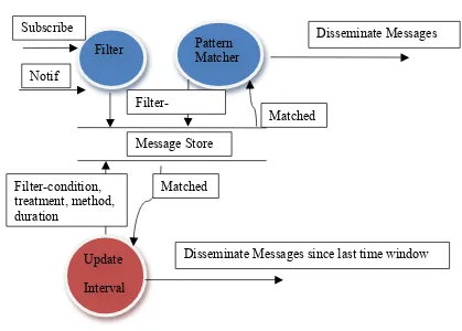
6.2.5 IfGI Event Service
One of the two ES implementations for OWS-9 was provided by the Institute for
Geoinformatics. It was based on the OGC Sensor Event Service discussion paper (OGC 08-133). The source code is maintained and provided in collaboration with the 52°North Initiative for Geospatial Open Source Software GmbH. Following the Publish/Subscribe paradigm of OASIS’ Web Service Notification (WS-N) family of standards, it acted as a notification broker. The IfGI ES has been used in aviation threads of former OGC test beds starting with OWS-6, including the FAA Special Activity Airspace (SAA) Dissemination Pilot.
Filter
Update Interval
Pattern Matcher Subscribe
Notif
Message Store
Disseminate Messages
Disseminate Messages since last time window Matched
Filter-Matched
6.2.5.1 Interfaces
The ES consisted of three endpoints. The PublisherRegistrationManager can be used to register data providers at the ES instance but was not used in this test bed and hence not described.
Endpoint Available Methods URL
Broker GetCapabilities, Notify, Subscribe
To enable SOAP bootstrapping both endpoints provide a WSDL using HTTP Get method (<endpoint-url>?wsdl).
Besides the GetCapabilities method, all available methods are defined by OASIS WS-N. The methods used in this test bed are described in the following table.
Method Description involved OWS-9
Component Notify Used to push a NotificationMessage to the ES. The contents are
Digital NOTAM Events or position update messages of an aircraft (sent by clients for demo purposes) and separated into different topics (NOTAM-Topic, Weather-Topic). This method does not use request-response communication, as notifications are pushed to the ES.
WFS providers, Clients (for demo purposes),
Performance Tool
Subscribe Used to define a subset of all incoming notifications. A subset can be defined using Topic filters, XPath Expressions and FES 2.0 filters. A SubscriptionReference is returned to the client, enabling the management of it. A Subscription can have an InitialTerminationTime (encoded as a period or a date time) to define its lifetime.
Clients,
Performance Tool
Unsubscribe Used to cancel a Subscription (e.g. when the flight has arrived). Clients,
Performance Tool
6.2.5.2 Changes to the Event Service Implementation
Compared to the ES used in the previous OGC test beds some major improvements have been made during this test bed. The IfGI Event Service implemented all features
6.2.5.3 Update Intervals
The implementation of the “Update Intervals” can be understood as an add-on to the existing event dissemination. As this feature has been designed using Subscription Policies, it does not affect any internal filtering mechanisms. Thus, an additional
component was designed to apply the Update Interval policy of a given subscription (see Figure 8).
Figure 9 Update Interval Internals 6.2.5.4 Simple Altitide Queries
The Altitude Queries implementation leveraged the WFS for applying the developed approach. A WFS providing Simple Altitude Queries capabilities provided all needed methods to enable outsourcing of the actual altitude computation at the Event Service. This feature was integrated at the time of DNOTAM reception: A previously defined subscription with altitude information (for OWS-9, aixm:RouteSegment was identified to provide all necessary parameter) was evaluated with a GetFeature request at the WFS. For instance, when receiving an update on an aixm:Airspace, the query defined the following parameters:
Property “gml:identifier” was equal to the one received in the DNOTAM.
Spatial Operator evaluated true for the aixm:RouteSegment of the Subscription. If and only if the query returned a non-empty result, the DNOTAM matched the given subscription and was disseminated to the subscriber.
6.2.6 Luciad Web Processing Service
6.2.6.1 Introduction
An OGC Web Processing Service (WPS) is a service that enables the user to perform a process (such as a computation) on a service. One use case is to offload heavy
implement or perform the computation themselves. Each process is described in a WPS profile, which lists the available input parameters and the structure of the response. Within the OWS-9 Aviation thread, the WPS was used for a number of processing tasks. Luciad provided a WPS service component based on its COTS software product
LuciadLightspeed to support the following OWS-9 use cases:
ePIB map generation
o Use case description: enable rendering of a list of Digital NOTAMs submitted by a user on top of an airport map. The response should be a bitmap image, ready for embedding in an ePIB.
o Solution: the logic to retrieve the airport map data and styling information was implemented by a WPS profile. The result was an SLD that embedded the combined feature data (Digital NOTAMs and airport layout features) and SE styling information, which was sent to an FPS for final rendering.
Geometry processing
o Use case description: support calculating the topology relation and intersection between two AIXM features, such as between a route and an airspace as illustrated in Figure 10.
o Solution: two WPS profiles are defined and implemented, one to check the topological relationship between two AIXM features (e.g. do the features intersect, is one feature contained in the other, are they touching, etc.) and one to calculate the actual intersection points between two AIXM features.