MODIS DATA ACQUISITION AND UTILIZATION FOR FOREST FIRE
MANAGEMENT IN INDIA
A.N.Satyanarayanaa B.Chandrasekhara Raob D.Lalithac B.Lakshmid
a
Manager, MODIS Data System, bGroup Head, Servo Drive and Mechanical Systems c Scientist ’SE’ dDy. Director, SDAPSA
Email: [email protected], [email protected]
Commission VI, WG VI/4
KEY WORDS: MODIS: Moderate Resolution Imaging Spectroradiometer, MBPS: Mega Bytes per second, DAQLB: Direct Archival and quick look browse, PSK: Phase Shift key, IF: Intermediate Frequency, RAM: Random Access Memory.
ABSTRACT:
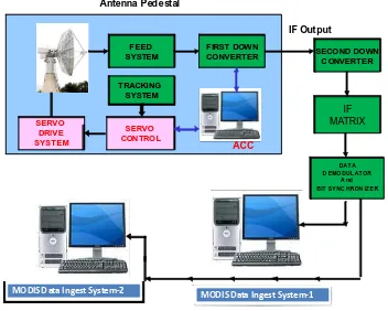
The Moderate Resolution Imaging Spectroradiometer (MODIS) instrument onboard Terra & Aqua Spacecrafts Scans the earth in 36 spectral bands & covers the entire earth in two days. MODIS data has proved to be very useful for ocean & land studies with resolution ranging from 250m to 1000 meters. The Data Reception system at Shadnagar (Refer to the Block diagram Fig.1), receives the data transmitted in X-band on 8160 MHz carrier SQPSK modulated with a data rate of 15MBPS from the Aqua satellite. The down converted IF signal is fed to the demodulator & synchronizer unit. The data and clock output signals of bit-synchronizer unit are given to a PC based DAQLB system where real-time telemetry processing is carried out and data is recorded onto hard disk in real time. The effectiveness of the system in supporting the forest fire management during the 2011, 12, 13 & 14 is also presented in the paper. Near real-time active fire monitoring, interactive fire visualization, fire database and statistical analysis functions also presented. Preliminary results of the upgrading satellite receiving system and in expanding the utilization of satellite data for multi-disciplinary resources management will also be presented and discussed.
1. INTRODUCTION
1.1 Forest Fires in India
Together with flood and drought, forest fire is one of the most frequently occurred natural disasters in I n d i a , causing severe damage to the country’s economy as well as to the forest ecological system. The most damaging are large fires at the primary dense forest, national parks, and conservation areas such as the famous fire at the hills of Uttar Pradesh & Himachal Pradesh.
As per the latest state of forests report of the Forest Survey of India the actual forest cover of India is 19.27% of the geographic area, corresponding to 63.3 million ha. Only 38 million ha of forests are well stocked (crown density above 40%). This resource has to meet the demand of a population of 950 million people and around 450 million cattle. As such, country has to meet the needs of 16% of the world's population from 1% of the world forest resources. The same forest has also to cater for the 19% of the world cattle population.
The forests of the country are therefore, under tremendous pressure. Forest fires are a major cause of degradation of India's forests[v]. While statistical data on fire loss are weak, it is estimated that the proportion of forest areas prone to forest fires annually ranges from 33% in some states to over 90% in other. About 90% of the forest fires in India are created by humans. The normal fire season in India is from the month of February to mid June. India witnessed the most severe forest fires in the
recent time during the summer of 1995 in the hills of Uttar Pradesh & Himachal Pradesh. The fires were very severe and attracted the attention of whole nation. An area of 677,700 ha was affected by fires.
The Forest Survey of India, data on forest fire attribute around 50% of the forest areas as fire prone. This does not mean that country's 50% area is affected by fires annually. Very heavy, heavy and frequent forest fire damages are noticed only over 0.8%, 0.14% and 5.16% of the forest areas respectively. Thus, only 6.17% of the forests are prone to severe fire damage. In the absolute term, out of the 63 million ha. of forests an area of around 3.73 million ha can be presumed to be affected by fires annually.
Since forest fires cover large areas, usually in hilly complex terrain, it is difficult to monitor them using conventional systems, especially for developing countries with little infrastructure and few resources for continuous monitoring of environmental variables. It is obvious that use of Earth Observation Satellite (EOS) data is potentially of great interest in early detection of forest fire in India’s land territory. The data from EOS series such as NOAA, Oceansat-2, and MODIS (Moderate Resolution Imaging Spectroradiometers) can provide information about the Earth’s surface in a wide range of wavebands including visible and near-infrared spectra, SWIR and in thermal range. Especially MODIS data, which include 6 bands in the thermal spectra of 3.66 – 4.08 µm and 10.78 – 12.27 µm, are currently used for early detecting fires or thermal anomalies.
FEED
MODIS D ata Ingest System-2 MOD IS D ata Ingest Syste m-1
2. THE MODIS DATA RECEIVING AND PROCESSING
SYSTEM
2.1 MODIS DATA
The Moderate Resolution Imaging Spectroradiometers (MODIS) are one of 5 sensors on board of TERRA satellite and AQUA satellite aiming at monitoring the change on the Earth’s land and sea surfaces and its atmosphere worldwide. The typical applications include atmospheric profiling, clouds studies, climatic characteristics, vegetation cover and the change in agricultural and forest lands, forest fires, ocean colour and ocean temperatures, etc. The MODIS data includes 36 bands in visible, infrared, short-wave and thermal spectra with spatial resolutions of 250 m, 500 m and 1000 m. MODIS data can be acquired regularly 2 day scenes and 2 night scenes for most of locations on the Earth’s surface. The frequent and synoptic characteristics (large swath of 2230 km) together with specially designed atmospheric bands of MODIS offer the alternative to lessen the cloudiness problem in monitoring environmental changes. MODIS will be very useful for natural disaster early warning and mitigation, which requires operational and near real-time information.
2.2 The NODIS Receiving Station and Data Processing The MODIS ground receiving station developed by the NRSC, Hyderabad. This is a complete X-Band for MODIS data receiving and processing with following components (Refer to the Block diagram Fig.1).
The MODIS data on 8160 MHz carrier SQPSK modulated at the rate of 15 Mb/sec is received at NRSC Ground Station by the 7.5 metre Antenna. The 8160 MHz carrier is down converted to a frequency of 720 MHz and is fed to a SQPSK demodulator and bit synchronizer to carry out the demodulation and bit synchronization of AQUA DB data. The (I+Q) serial data along with clock (ECL) is given to the PC based DAQLB system. The serial data is fed to a serial to parallel converter module, mounted in a Direct Archival PC. The 16 bit parallel data is ingested onto a hard disk via PCI bus & system RAM. Simultaneously the real time telemetry processing is carried out on data. The quality statistics of CADU frames and Quick Look is displayed on PC monitor in real time.
Figure 1. MODIS data reception systems configuration
Subsequently, raw data on disk recorded during real time is processed by level ‘0’ S/W which sorts out packets, carries out RS and PN decoding and generates PDS files. These PDS files are inputs for further level 1A/1B processing. The PDS files, GBAD files, ADIF files and Browse files are written onto DVD. One DVD is envisaged for all passes of the day. ADIF file and browse files are also transferred INFRAS System [iv].
The data are framed & browse images are generated with 512 pixels / 512 lines with panoramic correction. The corresponding metadata is also generated. The browse images are converted into JPEG files. The corner coordinates are also generated for browse frames and for accession catalog. The ephemeris data at the interval of one sec is generated which is used for browse and further level of processing. The browse images along with meta data is sent to processing system. (Fig.2 Overview of the MODIS Facilities at NRSC Ground Station)
Figure 2 Overview of MODIS facilities at NRSC
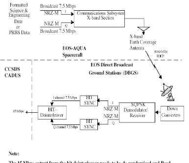
2.3 Data Reception Chain being input to the SQPSK receiver/demodulator. A separate tracking receiver is utilized for antenna auto-tracking purposes. The SQPSK receiver/demodulator demodulates the down converted signal into separate Q and I channel data streams. Following SQPSK demodulation, the bit synchronizers recover bit clock. The I and Q channels data are then combined into one single stream of 15Mbps (I+Q).
The AQUA Modis data is Reed-Solomon coded and CCSDS randomized. The Reed-Solomon coded and randomized data is bit interleaved into two streams of 7.5 Mbps (one for the I-channel and one for the Q-I-channel) before it is sent to the X-band modulators. Each data stream is sent using the Non-Return to Zero Mark (NRZ-M) format [iv].
After the bit synchronization derandomisation of the data, the data is Reed-Solomon decoded before feeding to the PCDQALB. Fig.2a shows the block diagram of data reception system.
Raw frames
Figure 2a Spacecraft –to-earth station downlink configuration for direct broadcast.
3. DATA RECORDING AND LEVEL ZERO
PROCESSING FOR DETECTION OF FIRE ALERTS
3.1 The following modules will run in real time
• Satellite Telemetry Processing Software (STPS) • Quick Look Display
• Data ingest to Disk
Data is written on the disk in raw packets form during real time. Data quality statistics of CADU is displayed on PC monitor and Quick Look is displayed during real time.
The Aqua and Terra Modis Data Reception System (ATMDRS) is the module that integrates all the level 0 activities and schedules the various processes like EPHGEN, DAQLD, PDSGEN, AUXEXT, SCOUT, BRWSEXT and ADIFVAL. Provisions are there for manually executing each of the above processes and for restarting the operations for a pass from any of the above processes. Besides this, utilities like Data Flush, PDS Display etc. are also integrated into this.
The input files for scheduling is the pass schedules file (vsb_aqa.ddd) generated by the EPHGEN program. The data flow diagram of Level ‘0’ process is shown in fig .3.The data acquisition GUI, stps software and snap shot of real time quick look is shown the fig3b.
Real Time
Figure.3 Level ’0’ Processing
Figure.3b Level ’0’ real time quick look
Figure.3c Real time data to Alert System
4. THE FOREST FIRE ALERT SYSTEM
Ground Station Shadnagar, where MODIS data is acquired. The network card was configured and Browse/ADIF files are being sent through Spacenet data link to the Indian Forest Fire Response and assessment system (INFRAS) has been providing operational MODIS based forest fire alerts to users. It is one of the successful monitoring programmes from remote sensing at National level.
4.1 MODIS Browse Data:
The browsing facility for the MODIS sensor of AQUA and TERRA satellites is provided on the Browse Archival and System. The Browse Archival and Server (BAS) system is designed to meet the requirement of browse data archival and retrieval [vi].
There are two modes under which this system operates
• As an archival system for archiving browse images and header data.
• As a server system, this can handle the user queries for browse archive search through java enabled web browsers.
The browse archival system receives the compressed browse images (in jpeg format) and header files as input. The browse images are copied onto the INFRAS system in a predefined directory structure. The header data is populated in to database.
RT-STPS Serial /parallel
Converter
Pass Sch. File
16 bit
RTSTPS Raw
Frames
PDS files DVD
PDS files
Segmentation BMP & JPEG files generation Meta data generation
Ephemeris PDS
file
Pass schedule file
Browse & meta data
DVD
Browse & Meta data to FIRE Alert System
The main functions of archival operations are:
• Ingests the browse images in to the dump area. • Archives browse images into respective directory
structure.
• Build the database
Browse Archival operations are to be carried out daily or whenever data comes from Shadnagar. The inputs for ingest and archival operations are satellite name and date of pass. And the output of the archival operations is image archive (images stored in a specific directory structure) and metadata database that contains Meta information about each scene. Server functions are initiated through client requests by connecting to the domain.
4.2 The main functions of the Server are:
• Display of the query forms to the client Date based query “Click here for available Passes” in the form by clicking which gives the acquired pass numbers for that particular date of pass. Pass based query allows the user to search on a particular pass number within a date range. It displays all the dates on which acquisition for that lat/long is made
• Process the form outputs to derive input for searching archives
• Searching the browse archives for the requested data • Format the search result to web compatible format. • Transfer the formatted output to the client
• Display the output on client screen with required links for navigation by user
5 INFRAS Forest fire alert – operational production through NRSC IMGEOS production Chain
The INFRAS activity was taken up jointly with Forest Survey of India from 2012, and monitoring in the fire season was done jointly. MODIS data receiving station has produced convincing practical results in applying remote sensing technology in natural resources management, particularly in operational management of forest fire. This practical experience will be very useful. The forests fires will be monitored more frequently, up to 8 - 10 scenes per day-night, and so improve the reliability of satellite-based fire detection. With this upgrading in hardware, the FPD satellite receiving system is also being expanded in terms of further development in data processing, presenting and interdisciplinary applications. Main features as follows:
Routine processing of satellite data generating forest fire hotspots using NASA ATBD-MOD14 Algorithm [vii]:
• Online interactive system for analyzing the hotspots, uploading onto online maps, which are interactively presented online to assist concerned local authorities in finding and locating the fire locations on the ground.
• Analyzing and classifying hotspots into probable forest fire and non-fire hotspots;
• Module for hotspots archiving and statistical analysis of historical fire data, risk mapping. • Online interactive system for communicating
forest fire information to the concerned local authorities;
• Generating and archiving level 1b data (with quick looks for interactive online reference) as online database for resources and environment applications.
In parallel, with increased satellite data acquired, and accumulated overtime, the FPD is working on using the short-term (daily) and long-short-term (yearly) time series to reduce the cloud effects and increase the reliability of the forest fire detection. Also, the integration with fire warning computed from regularly meteorological observations and updated forest information (maps) as well as utilizing the statistical analysis to comprehensively improve the forest fire management. Further, the data is staged on DEG and transferred in an automated to INFRAS production system. Processing routines for MODIS Level 0 to Level 1b are obtained from the NASA DRL repository. The output is the Level 1b MOD 14 product. The process flow is realised on a 64 bit Linux workstation shell scripts.
5.1 SATISTICS OF MODIS DATA ACQUISION DURING FIRE SEASON
The total numbers of passes acquired and archived are shown in year wise: Year: 2013-14: AQUA: 1399 passes and Terra: 1456, amounting for approx. 2TB data
The total numbers of passes acquired and archived are shown in year wise: Year: 2012-13: AQUA: 1389 passes and Terra: 1436, amounting for approx. 2TB data.
0
Note: 25 Dec 2013, 7 Days only Jul Month for 15 days only
The total numbers of passes acquired and archived are shown in year wise: Year: 2011-12: AQUA: 1379 passes and Terra: 1426, amounting for approx. 2TB data
6. CONCLUSION
The feature of near real time forest fire alert system in the Indian reason Forests-Bhuvan portal can be used. In recent days Himachal Pradesh is used near real time data of Forest fire alerts and that is being appreciated by forest department. Working on high-level data processing to produce level 2 and higher cloud-free products such as filtered/combined reflectance images, NDVI, surface temperature, sea surface temperature, and ocean colour, etc. With database built the I N F R A S aims at long-term monitoring the forest cover and forest status over the country. The INFRAS is looking to build cooperative framework with government offices, researchers and experts in order to promote the effective use of satellite data not only for forest fire management, but also for resources and environmental monitoring such as climatic studies, drought/flood monitoring, disaster mitigation, agricultural and ocean environment applications, etc.
7. ACKNOWLEDGEMENTS
It is indeed a great pleasure my sincere gratitude to my centre Director, NRSC and Dy. Director SDAPSA encouragement for producing this paper on future Satellite applications for Disaster Monitoring.
8. REFERENCES
i.A review of Selected MODIS Algorithms, Data Products, and Applications, Department of Earth Sciences, University of Memphis, Memphis, TN 38152, USA.
ii.Forest Protection Department, Ministry of Agriculture and Rural Development. Kaufmann Y. and Justice C., 1998.
iii. Project website:
http://tripwire.geog.umd.edu/usda/index.asp. iv.MODIS data acquisition, processing and scientific
utilization framework at the Institute of Industrial Science, University of Tokyo. Proceedings of the 22nd Asian Conference on Remote Sensing, Singapore, 1, 488- 492
v. Study on forest fire detection with satellite data, Mathias Milz, Avdelning Rymdteknik, and Institution for System- March 8, 2013.
vi. Schroeder, W., Prins, E., Giglio, L., Csiszar, I., Schimdt, C., Morisette, J., Morton, D. 2008. Validation of GOES and MODIS active fire detection products using ASTER and ETM+ data. Remote Sensing of
Environment 112 (2008) 2711–2726.
vii.Morisette, J.T., Giglio, L., Csiszar, I., Setzer, A., Schroeder, W., Morton, D., Justice, C.O. 2005. Validation of MODIS active fire detection products derived from two algorithms. Earth Interactions, 9:1-23.
viii. Roy, D.P. and Boschetti, L., 2009. Southern Africa Validation of the MODIS, L3JRC and GLOBCARBON Burned Area Products, IEEE Transactions on
Geoscience and Remote Sensing, 47, 4, 1032 – 1044,
doi:10.1109/TGRS.2008.2009000.
ix. Giglio, L., Loboda, T., Roy, D.P., Quayle, B., Justice, C.O., 2009. An active-fire based burned area mapping algorithm for the MODIS sensor,Remote Sensing of Environment, 113: 408-420.
0 10 20 30 40 50 60 70 80 90
Aqua Terra
0 10 20 30 40 50 60 70 80 90
Aqua Terra