A FRAMEWORK OF COGNITIVE INDOOR NAVIGATION BASED ON
CHARACTERISTICS OF INDOOR SPATIAL ENVIRONMENT
Ruochen SI* and Masatoshi ARIKAWA
Center for Spatial Information Science, The University of Tokyo, Kashiwa, Japan - (si, arikawa)@csis.u-tokyo.ac.jp
Commission/WG
KEY WORDS: Indoor Spatial Environment, Indoor Spatial Cognition, Interactive Positioning, Indoor Map Alignment, Active Navigation
ABSTRACT:
People are easy to get confused in indoor spatial environment. Thus, indoor navigation systems on mobile devices are expected in a wide variety of application domains. Limited by the accuracy of indoor positioning, indoor navigating systems are not common in our society. However, automatic positioning is not all about location-based services (LBS), other factors, such as good map design and user interfaces, are also important to satisfy users of LBS. Indoor spatial environment and people’s indoor spatial cognition are different than those in outdoor environment, which asks for different design of LBS. This paper introduces our design methods of indoor navigation system based on the characteristics of indoor spatial environment and indoor spatial cognition.
1. INTRODUCTION
Indoor spatial environment is labyrinthine, and indoor navigation systems are needed to guide people in indoor environment. On one hand, indoor positioning is one of the key problems in indoor LBS. Different equipment and methods are used for indoor positioning, such as WiFi, Bluetooth, LED lighting, dead reckoning, and so on (Evennou, F. and Marx, F., 2006; Altini, M., Brunelli, D., Farella, E. and Benini, L., 2010; Yang, S.-H., Jeong, E.-M., Kim, D.-R., et al, 2013; Fischer, C., Muthukrishnan, K., Hazas, M. and Gellersen, H., 2008; Renaudin, V., Yalak, O., Tome, P. and Merminod, B., 2007). However, the indoor positioning accuracy is still not high and stable, compared with outdoor GPS positioning results. On the other hand, the quality of LBS is also affected by factors other than positioning accuracy, such as map design, user interface design and so on. That’s to say, LBS quality can be improved by good design and use of maps and navigation systems. With this idea, we analyze the characteristics of indoor spatial environment and people’s indoor spatial cognition features, to achieve good indoor LBS.
The rest parts of the paper are organized as follows: section 2 analyzes characteristics of indoor spatial environment; section 3 analyzes features of indoor spatial cognition; section 4 introduces a framework of indoor LBS system that adapts to the indoor spatial and cognitive environment; section 5 introduce related prototype and experiment results; section 6 draws a conclusion.
2. INDOOR SPATIAL ENVIRONMENT
Indoor spatial environment is different than outdoor spatial environment. Five main characteristics of indoor spatial environment are as follows:
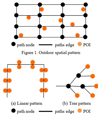
Simple spatial pattern. The outdoor roads and paths form complex network (see Figure 1). There are usually many ways to connect two points of interest (POI) in the road network. The topology of paths in indoor environment is simpler. Figure 2 shows two basic indoor spatial patterns: linear pattern and tree
pattern. For the linear pattern, POIs are stringed by a main path (include the case of ring). Linear pattern is often seen in office buildings and shopping malls. For tree pattern, one path leads to multiple paths at diverse points. Tree pattern are usually seen in trains and underground stations. Some complex indoor environment did form network topology, but many of them can be treat as compositions of the above two types of spatial patterns.
path node paths edge POI
Figure 1.Outdoor spatial pattern
(a) Linear pattern (b) Tree pattern
path node paths edge POI
Figure 2.Indoor spatial patterns
Multi-floors. The outdoor spatial environment is dominant with one ground surface, and tiles of maps are connected parallely. While indoor spatial environment can contain more than one surfaces, and layers of maps are overlaid vertically. This characteristic of indoor environment adds a discrete vertical dimension for indoor objects and brings differences in
The International Archives of the Photogrammetry, Remote Sensing and Spatial Information Sciences, Volume XL-4/W5, 2015 Indoor-Outdoor Seamless Modelling, Mapping and Navigation, 21–22 May 2015, Tokyo, Japan
This contribution has been peer-reviewed.
topological relations on indoor maps. For outdoor maps, the entrances and exists are on the edge of the maps; objects can cross multiple tiles of maps; one must move across the edge of the map to enter and leave a map, and must cross neighbour tiles of maps to reach points on further maps (see Figure 3). While for indoor maps, the entrances and exists can be both on the edge of the map and in the map; objects cannot cross multiple layer of maps (except for layer connecters such as stairs and elevators); one does not necessarily enter and leave at the edge of maps, and can skip neighbour layers of maps to reach points on further layer of maps (see Figure 4).
Figure 3. Topology relations on outdoor maps
Figure 4. Topology relations on indoor maps
Narrow view. Blocked by walls and corners, the view field in indoor is narrow. People can hardly get a whole view of indoor environment without a floor map. The narrow sight view makes it difficult for people to recognize an overall structure of the indoor environment.
Unique objects. In outdoor environment, many objects are not unique by name, such as chain shops. On the contrary, indoor environment is rich of unique spatial references, such as numbered rooms and shops. The unique references can help to locate people’s position in indoor environment.
3. INDOOR SPATIAL COGNITION
Affected by the characteristics indoor spatial environment, indoor spatial cognition also has different features from outdoor cognition.
Allocentric positioning. Allocentric floor maps are widely used for indicating users positions. The allocentric map alignment makes it easy for users to understand the overall structure of the indoor saptial environment and the relations of their positions to the indoor space.
Egocentric directing. In indoor environment, people rely more on egocentric relative relations (e.g. left to and right to) for directing. Absolute spatial directions (e.g. north to and south to) are difficult to recognize because of the narrow view of indoor environment.
Self-location description. Although people are easily get lost in indoor environment, it is convenient to describe self-location by unique spatial references, such as “in Room 101”, “in front of ABC Shop”, and so on. And by checking the near by spatial objects and self-moving trajectories, people can tell obvious
mistakes of positioning results of indoor navigation systems and make corrections.
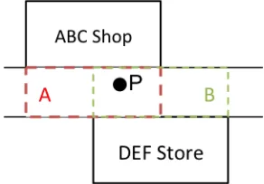
Cognitive collages. People recognize indoor space in the units of cognitive collages. A cognitive collage is an area in the indoor environment in which spatial cognition is continuous and smooth. Cognitive collages are separated by indoor spatial references, usually the rooms. Two points within same collage can be treated as same place while two points that do not belong to a same collage are treated as different places. LBS results are sensitive between different collages but insensitive within a same collage. Cognitive collages can be partly or completely overlaid. As shown in Figure 5, collage A and collage B are partially overlaid, and the point P can be described as either “in front of ABC Shop” or “in front of DEF Store”.
Figure 5. Indoor area is divided into cognitive collages by references, and cognitive collages can be overlaid.
4. FRAMEWORK OF COGNITIVE INDOOR NAVIGATION SYSTEM
We propose a framework of cognitive indoor navigation system that is designed based on the characteristics of indoor spatial environment and indoor spatial cognition. As shown in Figure 6, the framework contains three main parts: mapping, positioning, and navigation.
Figure 6. Framework of cognitive indoor navigation system
4.1 Mapping
We use the images of floor maps as resources to create map data for indoor navigation. The map images need to be geocoded to enable LBS. The following three kinds of information need to be geocoded onto map images.
Cognitive information. Virtual elements will be added for indoor navigation, including the center line of paths, positions of entrances of rooms, and so on. And we need to break the
The International Archives of the Photogrammetry, Remote Sensing and Spatial Information Sciences, Volume XL-4/W5, 2015 Indoor-Outdoor Seamless Modelling, Mapping and Navigation, 21–22 May 2015, Tokyo, Japan
This contribution has been peer-reviewed.
indoor space into subareas of cognitive collages by indoor spatial references.
Positioning information. Indicate the positions of indoor infrastructures that are used for positioning on the map images.
Illustrating information. Add multimedia content to enrich the indoor information, such as pictures of shops, texts of the discount information, audio guide of suggested POIs, short video of related events, and so on.
Table 1 shows the spatial types for geocoding the above information.
Information type Information item Spatial type
Cognitive
Table 1. Geocode different kinds of spatial information
4.2 Positioning
We use two positioning methods to get user’s position: interactive positioning and automatic positioning.
Interactive positioning requires users to report their current positions to the system. Two ways are provided for users to report their positions. One is report via referencing objects. There are many unique spatial references in indoor spatial environment, and users can use nearby reference’s name to report their positions, such as inputting “ABC Shop”. The other way to report self-position is by indicating directly on map. When users find their positions obviously wrong on the navigation system, they can directly tap on the map image to correct their positions.
Automatic positioning uses infrastructures’ signals to calculate user’s position automatically. As mentioned in section 1, there are many indoor positioning methods, but one common problem of current indoor positioning methods is the stability of positioning accuracy. Usually, indoor positioning accuracy is reasonable at check points near the infrastructures, but the accuracy decreases when leaving the infrastructures. For our system, infrastructures should be set at key places, such as decision points and the places that are difficult for people to report their positions.
The interactive and automatic positioning will work together to ensure reasonable positioning results all over the indoor maps.
4.3 Navigation
To adapt the navigation system to indoor spatial environment, we enable automatic map alignment function and active leading function for the system.
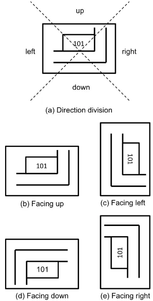
Automatic map alignment function is to rotate and align map images for convenient map cognition. Allocentric and egocentric map alignment are mainly used for floor maps. We use a combination of allocentric alignment and geocentric alignment for map presentation. As shown in figure 7, we divide four directions according to an allocentric floor map. When user is facing up, the map is not rotated; when user is facing left, the map is rotated 90 degree clockwise; when user is facing down, the map is rotated 180 degree; when user is facing right, the map is rotated 90 degree anticlockwise. This map
Figure 7. Map alignments for indoor navigation
The instability of positioning accuracy results in an unsmooth user trajectory during navigation, which leaves negative impressions to users. To solve the problem, we use a “You should be here point” instead of “You are here point” for indoor navigation. A leading point will be shown on the map image and automatically moving along the suggested path, and users will follow the leading point. Users can adjust the moving speed of the leading point to adapt to their walking speed. And the leading point can be enriched by illustrated information such as pictures and audios. The movement of the leading point is stable and smooth, which will leave users positive impressions on the system.
5. PROTOTYPE AND EXPERIMENT
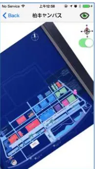
So far, we do not have a prototype of the cognitive indoor navigation system. However, we have developed an outdoor navigation system that share parts of similar functions of the proposed indoor system, including taking and geocoding map images, positioning on map images and auto-alignment of map images. Experiment on the outdoor navigation prototype achieved good results in positioning (Figure 8) and map aligning (Figure 9) which optimize us for realizing the prototype of the indoor navigation system
In the future, we will develop a prototype of the proposed indoor navigation system and do experiments on it and improve it according to the results of the experiments.
The International Archives of the Photogrammetry, Remote Sensing and Spatial Information Sciences, Volume XL-4/W5, 2015 Indoor-Outdoor Seamless Modelling, Mapping and Navigation, 21–22 May 2015, Tokyo, Japan
This contribution has been peer-reviewed.
Figure 8. Positioning results of user’s trajectory on related prototype of outdoor navigation system
Figure 9. Auto-alignment of map image on related prototype of outdoor navigation system
6. CONCLUSIONS AND FUTURE WORK
In this paper, we analysed the characteristics of indoor spatial environment and indoor spatial cognition. We found indoor spatial pattern is basically made up by linear pattern and tree patter, which is simpler than outdoor network spatial pattern; indoor space has narrow view and rich of unique objects that can be used as location references. We also found that allocentric map alignment is good for indoor positioning while egocentric map alignment is good for indoor directing; people can easily report their positions by the nearby spatial references and recognize indoor space with pieces of cognitive collages. Based on the analysis of indoor spatial environment and indoor spatial cognition, we proposed a framework of cognitive indoor navigating system. The system uses images of floor maps for LBS. It applies both interactive positioning and automatic positioning, and provides automatic map alignment and positive leading function for indoor navigation.
However, the usage situation is limited for some functions. For example, the interactive positioning function is fit for users who have free time, but not fit for users who are in a hurry.
In the future, we are going to develop a prototype of the proposed indoor navigation system, and do experiments to test its performance for improving the framework.
References
Evennou, F. and Marx, F., 2006. Advanced Integration of WiFi and Inertial Navigation Systems for Indoor Mobile Positioning. EURASIP Journal on Applied Signal Processing, 2006(01), pp 1-11.
Altini, M., Brunelli, D., Farella, E. and Benini, L., 2010. Bluetooth Indoor Localization with Multiple Neural Networks. 2010 5th International Symposium on Wireless Pervasive Computing (ISWPC), pp 295-300.
Yang, S.-H., Jeong, E.-M., Kim, D.-R., et al, 2013. Indoor three-dimensional location estimation based on LED visible light communication. ELECTRONICS LETTERS, 49(1), pp 54-56.
Fischer, C., Muthukrishnan, K., Hazas, M. and Gellersen, H., 2008. Ultrasound-Aided Pedestrian Dead Reckoning for Indoor Navigation. Proceedings of the first ACM international workshop on Mobile entity localization and tracking in GPS-less environments, pp 31-36.
Renaudin, V., Yalak, O., Tome, P. and Merminod, B., 2007. Indoor Navigation of Emergency Agents. European Journal of Navigation, 5(3), pp 36-45
The International Archives of the Photogrammetry, Remote Sensing and Spatial Information Sciences, Volume XL-4/W5, 2015 Indoor-Outdoor Seamless Modelling, Mapping and Navigation, 21–22 May 2015, Tokyo, Japan
This contribution has been peer-reviewed.