APPLICATION OF INFOWORKS MODELING FOR FLOOD MAPPING
MAONG RIVER
Jenny Kuihoon Anak Kulu
Bachelor of Engineering with Honours (Civil Engineering)
Universiti Malaysia Sarawak
Kota Samarahan
fk BORANG PENYERAHAN TESIS
Judul: APPLICATION OF INFOWORKS MODELING FOR FLOOD MAPPING
MAONG RIVER
SESI PENGAJIAN: 2001 - 2006
Saya JENNY KUIHOON ANAK KULU
(HURUF BESAR)
mengaku membenarkan tesis ini disimpan di Pusat Khidmat Maklumat Akademik, Universiti Malaysia Sarawak dengan syarat-syarat kegunaan seperti berikut:
1. Hakmilik kertas projek adalah di bawah nama penulis melainkan penulisan sebagai projek bersama dan dibiayai oleh UNIMAS, hakmiliknya adalah kepunyaan UNIMAS.
2. Naskhah salinan di dalam bentuk kertas atau mikro hanya boleh dibuat dengan kebenaran bertulis daripada penulis.
3. Pusat Khidmat Maklumat Akademik, UNIMAS dibenarkan membuat salinan untuk pengajian mereka. 4. Kertas projek hanya boleh diterbitkan dengan kebenaran penulis. Bayaran royalti adalah mengikut kadar
yang dipersetujui kelak.
5. * Saya membenarkan/tidak membenarkan Perpustakaan membuat salinan kertas projek ini sebagai bahan pertukaran di antara institusi pengajian tinggi.
6. ** Sila tandakan ( )
SULIT (Mengandungi maklumat yang berdarjah keselamatan atau kepentingan Malaysia seperti yang termaktub di dalam AKTA RAHSIA RASMI 1972). TERHAD (Mengandungi maklumat TERHAD yang telah ditentukan oleh organisasi/
badan di mana penyelidikan dijalankan). TIDAK TERHAD
Disahkan oleh
(TANDATANGAN PENULIS) (TANDATANGAN PENYELIA)
Alamat tetap: 142, GREEN HEIGHT PH 2
PROF. MADYA DR. F.J. PUTUHENA LRG LPGAN TERBANG 2A 1
( Nama Penyelia )
KUCHING, SARAWAK
Tarikh: Tarikh:
CATATAN * Potong yang tidak berkenaan.
** Jika Kertas Projek ini SULIT atau TERHAD, sila lampirkan surat daripada pihak berkuasa/
organisasi berkenaan dengan menyertakan sekali tempoh kertas projek. Ini perlu dikelaskan sebagai SULIT atau TERHAD.
The Following Final Year Project:
Title : APPLICATION OF INFOWORKS MODELING FOR FLOOD MAPPING OF MAONG RIVER
Name of the author : JENNY KUIHOON ANAK KULU Matrix number : 6618
Was read and certified by :
________________________ __________________
Prof. Madya Dr. F.J. Putuhena Date
i
ACKNOWLEDGEMENT
Thank you Lord for the love and blessing that you have give me through the years. To my supervisor, Professor Madya Dr. F.J. Putuhena, thank you for your guidance, support, ideas and mentorship throughout the course of this study.
Also thanks to Mah Yau Seng ,Master of Civil Engineering candidate, for this help and to all my lecturers, thank you.
iii
ABSTRAK
InfoWorks Sistem Sungai (RS) Versi 5.0 ialah sebuah enjin simulasi alur terbuka yang berkuasa dan ia mampu mengawal barisan bentuk alur, saiz dan cerunan. Perkara utama dalam pembelajaran ini ialah mempergunakan InfoWorks Sistem Sungai (RS) Versi 5.0 bagi pemetaan kawasan banjir dalam Sungai Maong, satu daripada cabang Sungai Sarawak yang berparas rendah. Dua senario digunakan, di mana kawasan banjir lebih kepada banjir luar and air pasang daripada Sungai Sarawak dan satu lagi ialah kawasan banjir lebih kepada hujan di dalam kawasan basin. InfoWorks Sistem Sungai digabungkan dengan permohonan Sisitem Maklumat Ilmu Alam (GIS) dalam pembelajaran ini untuk mendapatkan tindakbalas hidraulik pada Sungai Maong dan keadaan kawasan tanah rata sisi sungai. Maklumat diperlukan, persediaan, dan butiran rekabentuk yang hampir dibentang. Akhir sekali perbincangan dari projek menghasilkan cadangan untuk kegunaan masa akan datang diberi untuk membuat kesimpulan dalam projek ini.
ABSTRACT
InfoWorks River System (RS) Version 5.0 is a powerful open channel simulation engine, and is able to handle a wide range of channel shapes, sizes and gradients. The main purpose of this study is to apply the InfoWorks River System (RS) Version 5.0, for mapping the flood area in Maong River, one of the tributaries of Lower Sarawak River. Two scenarios were applied, which are the flood area due to external flood and high tide from the Sarawak River and the other is the flood area due to internal storm in catchment. InfoWorks RS, coupled with its embedded Geographical Information System (GIS) application has been used in this study to capture the hydraulic response of the Maong River and its floodplains conditions. Data requirement, preparation, and details on modeling approach are presented. Finally, a discussion of the project limitation and recommendation for further application is given to conclude this project.
v
Table of Contents
Content Page Number
Acknowledgment ii
Abstrak iii
Abstract iv
List of Tables viii
List of Figures ix
List of Appendix xi
List of Abbreviations & Notations xii
Chapter 1 : Introduction
1.1 Background 1
1.2 Waterlevel 5
1.3 Objective 8
Chapter 2 : Literature Review
2.1 Floodplain 9
2.2 Floodplain Hydrologic and Hydraulic Analysis 10
2.3 Rainoff-Runoff 11
2.3.1 Modified Rational Method 11
2.4 Hydrodynamic Routing 14
2.4.1 Saint – Venant Equations 15
2.5 Hydrologic Routing 19
2.5.1 Lumped Reservoir Routing 20
2.5.2 Lumped River Routing 21
2.6 Application of Geographical Information System (GIS) 24 2.6.1 GIS-Based Hydrologic and Hydraulic Model 25
Chapter 3 : Methodology
3.1 Introduction 27
3.2 Hydraulic Model Input Preparation 28
3.3 Model Building in InfoWorks 31
3.4 Boundary Condition 35
3.5 Model Result 37
Chapter 4 : Results and Discussions
4.1 Results 38
4.2 Flood Depth 42
4.3 Flood Stage Hydrograph 53
4.4 Longitudinal Section 55
4.5 Flood Mapping 57
vii Chapter 5 : Conclusions and Recommendation
5.1 Conclusions 61
5.2 Recommendations 62
References 63
List of Tables
Table Page Number
1.1 Characteristics of Maong River 4
1.2 Sarawak Hydrology Station Inventory 6
4.1 Data Flow in 24-Hour Storm 41
ix
List of Figures
Figures Page Number
1.1 The Maong River Catchment Location Plan 2
1.2 Maong River Catchment – Subcatchment 3
1.3 Hydrological Station at Maong River 7
2.1 Natural leeves form on its banks. 10
2.2 Time- Area Method 14
2.3 Development of the storage-outflow function 21 3.1 Projected Digital Map of Maong River Using 29
ESRI ArcView
3.2 TIN Surface Model of Maong River Using ESRI 30 ArcView 3D-Analyst Extension v1.0
3.3 Viewing of Digital Terrain Model of Maong 32 River Using GeoPlan of Infoworks RS
3.4 Viewing of Maong River Network Using Geoplan 33 of Infoworks RS
3.5 Viewing the Section Data of Maong Main 1b 34 3.6 Property Sheet-Flow Time Boundary of Central Park 36 3.7 Property Sheet-Stage Time Boundary of Maong Mouth 37 4.1 Water Level Data Hydrograph at Maong Mouth 39
(Jan 21 & 22, 2000)
4.2 Water Level Data Hydrograph at Maong Mouth 39 (Jan 1 & 2, 2000)
4.3 100 Years Flood Hydrograph For Maong River 40 As Estimated by D.I.D
4.4 (a) Maong Kanan 3 Cross Section (Jan 22, 2000) 43 4.4 (b) Desa Wira A Cross Section (Jan 22, 2000) 43 4.4 (c) Maong Kanan 5 Cross Section (Jan 22, 2000) 44 4.4 (d) Central Park A Cross Section (Jan 22, 2000) 44 4.4 (e) Maong Tengah Kiri Cross Section (Jan 22, 2000) 45
4.4 (f) Maong Main 2 Cross Section (Jan 22, 2000) 45 4.5 (a) Maong Kanan 3 Cross Section (Jan 1, 2000) 46 4.5 (b) Desa Wira A Cross Section (Jan 1, 2000) 46 4.5 (c) Maong Kanan 5 Cross Section (Jan 1, 2000) 47 4.5 (d) Central Park A Cross Section (Jan 1, 2000) 47 4.5 (e) Maong Tengah Kiri Cross Section (Jan 1, 2000 48 4.5 (f) Maong Main 2 Cross Section (Jan 1, 2000) 48 4.6 Minimum Inundation Area At Beginning of 49
Strom for 1st Scenarios (Jan 21-22, 2000)
4.7 Maximum Inundation Area for 1st Scenarios 50 (Jan 21-22, 2000)
4.8 Minimum Inundation Area At Beginning of 51 Strom for 2nd Scenarios (Jan 1-2, 2000)
4.9 Maximum Inundation Area for 2nd Scenarios 52 (Jan 1-2, 2000)
4.10 Flood Stage Hydrograph at Central Park for 53 1st Scenarios (Jan 1-2, 2000)
4.11 Flood Stage Hydrograph at Central Park for 54 2nd Scenarios (Jan 1-2, 2000)
4.12 Flood Longitudinal Section at Maong Main For 56 1st Scenarios (Jan 1-2, 2000)
4.13 Flood Longitudinal Section at Maong Main For 56 2nd Scenarios (Jan 1-2, 2000)
4.14 1st Scenarios Flood Map on January 21-22, 2000 58 4.15 2nd Scenarios Flood Map on January 1-2, 2000 59
xi
List of Appendices
Appendix Page Number
List of Abbreviations & Notations
3-D Three-Dimensional
∆t Time Step
A Area in km2
AutoCAD Automatic Computer Aided Design DEM Digital Elevation Model
D.I.D Sarawak Department of Irrigation & Drainage Sarawak DTM digital Terrain Model
DUFlow Dutch Flow, a licensed hydraulic modeling software ESRI Environmental sciences Research Institute
ESRI ArcView A GIS software package of ESRI
GeoPlan Geographical Plan, a GIS tool of InfoWorks RS GIS Geographical Information System
Hr Hour
HEC Hydrologic Engineering Centre HEC-2 A modeling software package of HEC
HEC-RAS River Analysis System, a modeling software package of HEC HSPF Hydrologic Simulation Program – Fortran
InfoWorks A licensed hydraulic modeling software of Wallingford Software Ltd. UK
xiii
ISIS A licensed hydraulic modeling software of Wallingford Software Ltd. UK
m AD Elevation Level Above Datum m LSD Elevation Level of Standard Design m M.S.L Mean Sea Level
NREB Natural Resources Environmental Board TIN Triangular Irregular Network
APPLICATION OF INFOWORKS MODELING FOR FLOOD MAPPING OF MAONG RIVER
JENNY KUIHOON ANAK KULU
This project is submitted in partial fulfillment of the requirement for the degree of Bachelor of Engineering with Honours
(Civil Engineering)
Faculty of Engineering
UNIVERSITI MALAYSIA SARAWAK 2006
1
CHAPTER 1
INTRODUCTION
1.1 Background
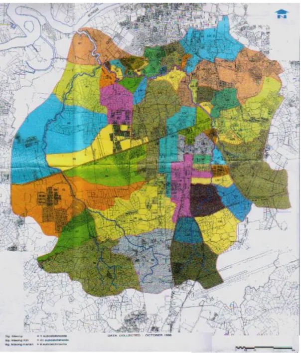
The Maong River confluence with the Sarawak River about 37km from the river mouth. Maong River is one of the tributaries of Sarawak River. It has 2 tributaries, namely Maong Kiri River and Maong Kanan River. Table 1.1 shows the Characteristics of Maong River. The area coverage is approximately 47km2 catering for about 73,000 people. The Maong River Catchment Location Plan is shown in Figure 1.1. The main river serves 1 subcatchment, comprised of mainly undeveloped land on both sides of the river. Maong Kiri serves the eastern position of the Maong River Catchment and 41 urbanised subcatchments comprising mainly residential and commercial establishments whereas Maong Kanan River serves the western portion and 9 subcatchments, which are mainly residential (Desa Wira) and undeveloped lands except the Proposed Muda Jaya City Development at Batu Kawa. There are 3 main roads across it, Batu Kawa Road, Kung Phin Road and Semaba Road (See Figure 1.2).
3
Figure 1.2 Maong River Catchment – Subcatchment ( Source : Department of Irrigation & Drainage Sarawak)
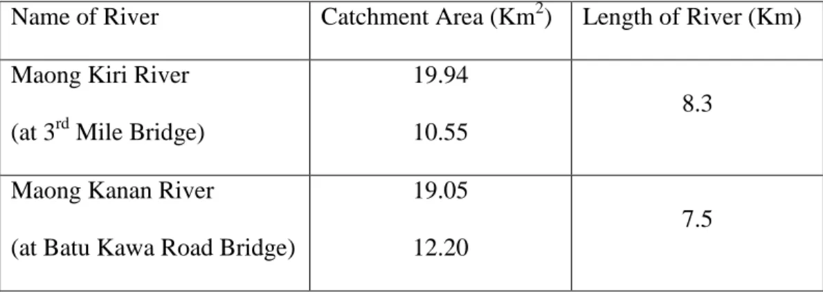
Table 1.1 Characteristics of Maong River
Name of River Catchment Area (Km2) Length of River (Km) Maong Kiri River
(at 3rd Mile Bridge)
19.94 10.55
8.3
Maong Kanan River
(at Batu Kawa Road Bridge)
19.05 12.20
7.5
( Source : Department of Irrigation & Drainage Sarawak)
The existing Maong River is effected by many problems, including flash flooding, poor water quality, poor river aesthetics and perceived by the general public as a waste dumping conduit. It heavily polluted by organic matter. BOD levels and ammoniacal nitrogen concentrations are very high and the oxygen conditions are extremely poor (NREB 2002).
Maong River is located upstream of Sarawak River Barrage, so it is influenced by the Barrage and the operation of the gate. According to the Drainage and Irrigation Department contoured Topographical Plan, the major part of the Maong River Catchment is low-lying and flat with ground levels generally range from below 2.5 mLSD to 5.0 mLSD. Hilly terrain occurs at the north eastern and southern part of the catchment with ground levels range from 7.5 mLSD to 20 mLSD. With reference to the operation of the Sarawak River Barrage which allow high tide to
5
enter Sarawak River within the regulated water level of 1.4 mLSD, those areas that are below 2.5 mLSD are susceptible to flooding from either tidal events, rainfall events or a combination of both. Areas that have ground level between 2.5 mLSD to 5.0 mLSD will not be flooded regularly after control by the Barrage but may be subject to flooding from backwater effect of the inadequate waterway section and high water level at the drainage outlet.
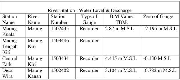
1.2 Water Level
Table 1.2 Sarawak Hydrology Station Inventory shows four waterlevel stations were installed to facilitate a detail investigation into the local tidal phenomena at Maong River. Four automatic water level are situated at the Central Park Station at the Maong Kiri River and Maong Kuala Station at the mouth of the Maong River. The other water level station are Maong Tengah Kiri Station at the Maong Kiri River and Desa Wira Station at the Maong Kanan River. Figure 1.3 is show the location of hydrological station. The first installation of automatic water level for Central Park Station was in November 4, 1995, Maong Kuala Station and Maong Tengah Kiri Station were in April 4,1996 and Desa Wira Station was in May 25, 1996. Before that all the station were using manual water level. For the Ulu Maong Station located at the Hui Sing was stop operation since 1997 because too many missing data. Their immediate function is to confirm the extent and duration
of inundation and flooding. The water level data for the mouth of January 2000, for all the stations are given in Appendix A.
There are two different types of flood in the Maong River Area i.e. internal floods and external floods. Internal floods are observed everywhere in the catchment after heavy rainfalls during the landas season. They are caused mainly by the fact that the existing channel is too small and meandering and cannot accommodate the runoff from high intensity storms. External floods are caused by high flood water and high tides from Sarawak River. The king tide levels when coupled with high intensity rainfall will flood some of the low-lying areas. The most critical condition arises when both king tides and flood water from upper tributaries reach a place at the same time. This had happens at the lower reaches of the Maong River.
Table 1.2 Sarawak Hydrology Station Inventory
River Station : Water Level & Discharge Station Name River Name Station Number Type of Gauge B.M Value: TBM: Zero of Gauge Maong Kuala Maong 1502435 Recorder 2.87 m M.S.L -2.195 m M.S.L Maong Tengah Kiri Maong Kiri 1503446 Recorder Central Park Maong Kiri 1503434 Recorder 4.445 m M.S.L -0.130 M.S.L Desa Wira Maong Kanan 1502402 Recorder 3.104 m M.S.L -0.782 m M.S.L