STUDY ON LAND SUBSIDENCE INCANGZHOU AREA BASEDON SENTINEL-1A/B
DATA
Hongyue Zhou , Yunjia1,2 Wang1,2, *, ShiyongYan1,2
1.SchoolofEnvironmentScienceandSpatialInformatics,ChinaUniversityofMiningandTechnology,Xuzhou, China
2.NationalAdministrationofSurveying,MappingandGeo-Information(NASG)KeyLaboratoryofLand EnvironmentandDisasterMonitoring,Xuzhou,China)
KEY WORDS:Sentinel-1A/B, Time Series InSAR, Cangzhou area, Land Subsidence
ABSTRACT:
This paper, obtaining 39scenesof images of the Sentinel-1 A/B, monitored the Cangzhou area subsidence from Mar. 2015 to Dec. 2016 basing on using PS-InSAR technique. The annual average subsidence rate and accumulative subsidence were obtained. The results showed that the ground surface of Xian County,Cang County, Cangzhou urban area had a rebound trend; Qing County, the east of Cang County ,the west of Nanpi County and Dongguang County appeared obvious subsidence, and the accumulated subsidence in Hezhuang village of Dongguang County reached 47mm.And from that the main reason leading to these obvious subsidence was over-exploitation of ground -water. At last, it analyzed the settlement of the High-Speed Railway (HR) which was north from the Machang town of QingCounty and south to the Lian town of Dongguang County in Cangzhou.The relative deformation of the HR between the two sections which was Lierzhuang village of Cang County and Chenxin village of Nanpi County arrived at 30 mm.Moreover, this paper discussed the application of Sentinel-1 A/B SAR images in monitoring urban land subsidence and the results provided important basic data for the relevant departments.
1.INTRODUCTION
Land subsidence is a common geological environmental problem, with the characteristics of long time, large scale and complex factors. There have been many cities in China which had occured to different magnitudes of subsidence, causing huge economic losses. The most typical city of Huabei Plain was Cangzhou, Hebei Province,China. Over the past 40 years, the land subsidence of Cangzhou had been serious, and the large range settlement on the land surface damaged seriously the surface structure and the ground-up buildings, which also threatened the urban residents' property and the lifesafety.Therefore, it has been of great value for this city to monitor the serious areas, especially to reach short-cycle monitoring, high precision and wide range. Finally providing latest settlement information for relative departments of Cangzhou had much
significance.
Compared with the conventional monitoring technologies, the Space-to-Earth Observation Technology(SEOT) has made great progress in recent decades.Synthetic Aperture Radar Interferometry (InSAR) as a kind of SEOT, with the advantages of working all day long, wide monitoring range, low cost and accuracy in cm magnitude, has been widely used in monitoring deformation of mining(Chang H S,2005), volcano(Li P,2015), earthquake(Li Y S,2016), urban land subsidence(Liu X,2016) even major projects (He X F,2011).
Antonio-pepe, 2005).The two technologies effectively solved the problems of spatial decorrelation and atmospheric delay of DInSAR, and greatly improved the precision of surface deformation monitoring and showed great potential in monitoring long time accumulated and slow deformation ,such as urban surface deformation(Chen ,2014).
As ALOS-1andENVISAT satellites lost the working ability, in this paper we used 39 scenes of images obtained by the Sentinel-1 (S1) A/B satellites which covered the most Cangzhou areas, to realize the nearly-real-time, low-cost and wide-range monitoring goal. And the time series(TS) analysis techniques of PS-InSAR and SBAS-InSAR were used to study on the Cangzhoudistrict' and its surrounding counties' land subsidence along the line of sightdirection(LOS), and the monitoring period began from Apr 2015 to Nov 2016. Finally, we focused on monitoring the deformation of urban surface and acquired the annual average deformation rates by using the TS-InSAR. Moreover, we analyzed the subsidence situation in Cangzhou areas and the results were provided the basic information about preventing from disasters and making decision for relevant departments.
2.PS-InSAR Algorithm
Permanent scatterer synthetic aperture interferom-etry(PS-InSAR), was first proposed by Ferretti (Ferretti et al,2000).The detailed process is as following: first step is to get enough SAR images(usually more than 25) which covered the study area; Secondly select one image as the master image considered constraints on the spatial, temporal, noise and dopper centroid baselines from the all SAR images. Then use it to carry out the differential interference processing with the rest images; Thirdly basing on the pixel amplitude variability threshold and phase information selects PS candidates, and picks bright PS relying on the standard deviation and SNR, which is used to accurately eliminate and removes the scattering phase, phase separation and atmospheric delay phase errors; Finally obtain high precision about time series surface deformation information of the study area.
1) Data preprocessing
Selecting the master image needs to be considered the time baseline, space baseline, Doppler centroid frequency and thermal noise baseline of four errors, through calculating the four absolute values of each image and taking the minimum one of images as the master image. The formula is as following:
= temp Spat DC thermal
(1)
is the interferograms' coherencecoefficient,
temp,
Spat,DCand
thermalrepresent thetime baseline, spatial baseline, Doppler centroid frequency and noise errors.
2 ) Selecting and Screening PS points
The selection principle of selecting PS points is to select and identify as high many reliability points as possible, with the methods such as amplitude discrete exponential threshold method, phase coherence coefficient threshold method and phase discrete threshold method. In this paper, we adopted tothe method of combining phase coherence coefficient threshold method with the phase discrete threshold method to select the candidate points and to weed these PS points whose standard deviations were not more than 1.0 and the weed-noise threshold was less than 1.5 (Hooper,2012).
3) Removing DEM, Orbit and Atmospheric Delay Error
Considering the strong correlation between the orbital errors and the atmospheric delay phase errors, the unwrapping phase was subjected to high-pass filtering in the time dimension, and the unwrapped phase is low-pass filtered in the spatial dimension, and using the master image was estimated from all the orbital errors of the interferograms and the atmospheric delay errors. Through removing the above errors, the deformation phase information would be extracted accurately.
4) Extracting the deformation
calculates the average deformation rate of all PS points along the LOS direction and finally the surface deformation of the study area was acquired.
3. STUDY AREA AND DATA SOURCE
According to the relevant literature (He Q C,2006;He Q C, Fang,2006), the Cangzhou ground- water level funnel area in 1972 to 2002, had fell more than 80 meters; in 2003-2010, the city's entire area in the rapid sinking stage (Zhang,2014); 2012-2014 The trend of settling in the Cangzhou urban area has slowed down (Gao,2016;Zhang,2016). Due to over-exploitation of groundwater, the whole area has formed the main settlement areas such as Qing, Dongguang County, Renqiu and Botou, and had evolved into two
settlement belt of Qing-Cangxian-Botou-Dongguang County and Renqiu-Suning-Xian belt. Until 2014, Cangzhou area's subsidence center had accumulated almost at 3m (Zhang L,2016). With the increasing of rainwater in recent years, the frequent flooding events in summer have seriously affected the daily
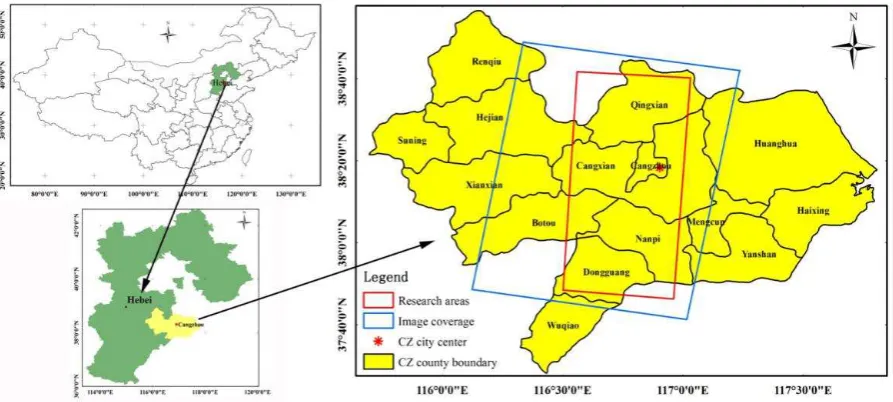
production and life of urban residents, which had attracted the attention of the relevant departments (Wang,2015). Therefore, the Cangzhou area has been needing short-cycle and nearly-real-time monitoring land subsidence. The boundary of this study was shown inFigure1, in which the blue wire frame that was the SAR image coverage, and red wire frame that was the focus on the studyarea.
Figure 1.The location map of Cangzhou City,is backed by Beijing and Tianjin, south of Shandong, east of the Bohai Sea, west of Hengshui, which is including 14 counties and three districts (Xinhua, Yunhe and Development Zone). the total area of Cangzhou is nearly 14500km2,and also is one of the rapid economic development of the Hebei Province cities.
Sentinel-1(S1-A/B) satellites were developed by European Space Agency(ESA), of which the S1-A was launched on April 3, 2014 and officially released after six months of trial operation and the S1-B officially released since September 2016. There are four kinds of S1 imaging modes, including the Stripmap(SM),Interferometric Wide Swath(IW),Extra Wide Swath (EW), Wave mode, Which IW mode images could be downloaded in free charge (Yang,2014;Wang 2016). The S1 SAR images had the characteristics, such as large coverage, multi-polarization, short the repeat-cycle (12 days), and
were applied to monitoring urban long-term sequence subsidence (Zhang,2016). In the paper, we chose 39scenesof S1 IW mode SAR images covering the Cangzhou main county areas. The external reference DEM was SRTM3 DEM, whose perpendi-cular accuracy is better than 16m (Chen,2005).
processing needed to consider the effects of the Doppler center frequency shift on resampling SLC, which increased the difficulty of images'
co-registration(Xia,2010);to meet the precise registr-ation, the azimuthal registration error should been less than 0.001.
4 RESULT AND DISCUSS
In this experiment, the PS-InSAR time-series method was used to obtain the differential interferograms to the spatial and temporal baselines (Figure.2), and selected the image acquired on February 7, 2016 as the master image. From the formation of 38scenes differential interferograms, we finally selected 68591 PS points, and the maximum space vertical baseline was174.1m; the Figure 4.2 was settlement rate Figureure, where A were the stability of the study area of the reference area, the all PS points' deformation were relative to the reference area along the LOS direction.
The analysis ofFigure 2, Figure3 showed that the most serious subsidence areas of Cangzhou occurred in Qing and Dongguang County. East Xian County, Cang County, West and Cangzhou center, the eastern
part of Cang County, the northeastern part of Hejian County, the eastern part of Renqiu and the eastern part of Nanpi County showed moderate subsidence. Therefore ,we next focused on monitoring and discussing the subsidence of Qing-Cangzhou-Botou-Dongguang County subsidence belt.
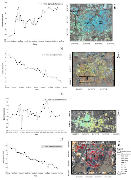
Considered the interval time of images acquired was relatively short. So we could take the advantages on analyzing the factors of rainfall and seasonal change which influenced the key subsidence conditions of Qing areas, Dongguang and Botou County. In the Qingzhou of Qing, Xinhua District of Cangzhou City, Botou Town, Dongguang Town of Dongguang County, the subsidence areas were large and the statistical time series PS point average rates and the time series subsidence were draw in (a),(b), (c),(d) ofFigure4.
Figure 3. Cangzhou area of the settlement deformation rate map, the red wireframe represented the focus area .The subsidence of Qing-east of Cangxian-Nanpi-Dongguang along the north and south of Cangzhou was serious obviously; especially in some areas of Qing and Dongguang, the cumulative settlement was more than 30mm / a, and the most serious areas of the subsidence reached 50mm/a; compared to the east along the Xian-west of Cangxian-urban areas began rebounded referring to the reference area.
(a)
(b)
(d)
Figure 4.The time series subsidence map of Cangzhou area. The bakeground of it was the images of Google and the SAR intensity images ,where (a), (b),(c) and (d)separately represented the Xinhua District of Cangzhou, Qingzhou of Qing Botou Town, Dongguang Town. Cangzhou region and the Botou area, which is influenced by the seasonal variation, which can be analyzed in the Cangzhou area and the Botou area, In the period from June to August in June, the deformation of the variable fluctuates greatly, and the performance is declining. The relative Qing and DongGuang are stable and subsided during the whole monitoring period, and the results are consistent with the cumulative subsidence in Dongguang's Hezhuang Villageup to 100mm.
From theFigure4, it was showed above four areas of the settlement in the range of 10mm fluctuationsin April 2016 to November 2016.The cumulative settlement of Qingzhou Town reached at 33mm; the ground performance of Cangzhou City rised rapidly after a slight settlement, and the cumulative rise was nearly 20mm; In Botou and Dongguang County, the overall performance of the subsidence rose at first ,next fell and finally showeda small rebound, the cumulative subsidence were at 2mm and 46mm separately. Analysis of the reasons leading to the land subsidence phenomenon of Cangzhou: First, the difference in rainfall, according to the relevant data, in June 2016 to early 2016, Botou, Qing rainfall in the 450 ~ 500mm, Dongguang, Cangzhou urban rainfall In the range of 400~450mm, rainfall by supplying groundwater caused by Qing and Cangzhou urban surface of the larger rebound (Dai,2014;Hui,2016); Secondly, the rock geological structure different from the surface of the average annual surface deformation was generally no more than 2mm(Gao,2016); Thirdly, the different trends in urban development, Qing through the construction of the north and south through the "Beijing and Tianjin Development Gallery", Dongguang County on the eastern side of the region with 104 National Road, and Beijing-Shanghai railway, the current rapid development of two cities had land surface activities frequently; Fourthly, the amount of groundwater extraction was different from the cities in industrial and residential water-based, and agricultural water requirement. In the summer of the southern region of Dongguang' surrounding areas, agricultural water consumption caused large amount ofgroundwater exploitation, which resulted in the surface in the
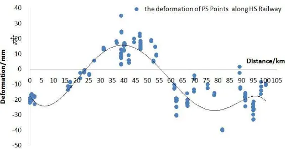
summer occurring substantial settlement fast. In October 2016 to November 2016, due to reducing agricultural irrigation water, the land surface showed a slight rebound trend .From the above analysis, we concluded that the main reason for the settlement of Cangzhou area was the groundwater exploitation. Finally, we aimed at monitoring the subsidence of high-speed railway line from Maoxian Town, from Cangzhou North to in the south of Dongguang County. With the high-speed rail line as the center, the two sides of the extension of the area within 200 meters as the roadbed, then established HR line buffer analysis, to screen the roadbed PS points. Finally, the distance between all the PS points of the sub-grade along the starting position was plotted.
It could be seen fromFigure5 that the high-speed rail line in the study area were more than 100 kilometers long and 848 PS points were screened along the high-speed subsidence zone. The trend of roadbed deformation reflected by these PS points was highly consistent with the trend of the county where the line was located, and there was obvious non-uniform settlement between the sub-grade along the HR railway. In Qing County , before the fishing two village and Cangxian Zhang Zhuangzi village 10 km along the roadbed relative reached 20mm; in Cangxian Li Erzhuang village and Nanpi County north of Fengjiakou town Chen Xin village section, the relative settlement of roadbed were at amount of 30mm.The above the road section of the railroad had been a large relative settlement causing the
Figure 5.The PS points' subsidence along High-Speed Raliway in Cangzhou
5 CONCLUSION
The short-period and nearly-real-time of monitoring settlement area was studied by using S1-1A/B SAR data. The results showed that the S1 data had great application value in monitoring urban subsidence. In the absence of measured data, by comparing the PS-InSAR technology to acquire the verify the reliability of the settlement monitoring results, fully played the advantages of time series InSAR technology; made a relatively deep discussion on the S1 data in the monitoring urban land subsidence. Analyzed the basic settlement of the Cangzhou area during Apr. 2015 to Nov. 2016, and discussedthe influence of rainfall and agricultural water on the surface subsidence evolution in Cangzhou area, and analyzed the main reason of the subsidence .
In the future study, we should obtain the high precision leveling data of Cangzhou city, and further verify the reliability of the InSAR monitoring results. We should collect the data of groundwater exploitation in Cangzhou as a whole, and fully excavate the surface subsidence rate of Cangzhou and the groundwater exploitation quantitative relationsh-ip.
ACKNOWLEDGMENTS
For the successful completion of this study, it is extremely grateful to the ESA free of charge for providing the S1-A/B images; at the same time for Hoopper and others provided StaMPS opened source code expressed gratitude; at last Funding was provided by Natural Science Foundation (GrantNo. 5157041473), Natural Science Foundation of Jiangsu Province(Grant No. BK20150189).
REFERENCES
Antoniopepe,et al. 2005.On the generation of ERS/ENVISAT DInSAR time series via the SBAS technique[J]. IEEE Geoscience and Remote sensing letters, 2(32):65-269.BAI Xia,SUN Jinping,HONG Wen. 2010.On the TOPS ModeSpaceborne SAR[J]. Infomration Sciences, 53( 2) : 367-378.
Beibei Chen,Huili Gong,Xiaojuan Li,et al.
Spatial-Temporal Evolution Characterization of land Subsidence by Multi-Temproal InSAR Method and GIS Technology.Spectroscopy and Spectral Analysis,34(4):1017-1025.
Chang H.S,G LL,R C. Mine Subsidence Monitoring Using Multi-source Satellite SAR Images[J].IEEE International Geoscience and Remote Sensing Symposium , 2005,1742-1745.
Fengrui Wang.2015. Analysing the Influence of 2015.8.31Storm water in Cangzhou. Haihe River Water Conservancy,04:35-36+55.
Fenglin Hui, Jianqiang Ha, Guoqiang Liu.2016. The Characteristics of Rainwater in Cangzhou City during Flood Season,2016.09.13.
Ferretti, A., Prati, C., and Rocca, F. 2000. “Nonlinear subsidence rate estimation using permanent scatterers in differential SAR interferometry.”IEEE
Transactions on Geoscience and Remote Sensing, Vol. 38(No. 5): pp. 2202–2212. doi: Doi
10.1109/36.868878.
Hooper, A., Bekaert, D., Spaans, K., and Arikan, M. 2012. “Recent advances in SAR interferometry time series analysis for measuring crustal deformation.”
doi:10.1016/j.tecto.2011.10.013.
Junyong Chen. 2005.Quality Evaluation of Topographic Data from SRTM3 and GTOPO30. Geomatics and Information Science of Wuhan University,30(11):4-7.
Kui Yang, Jianbing yang, Bingru
Jiang.2015.Sentinel-1 Satellite Overview. Urban Geotechnical Investigation &Surveying, 02:24-27. Ling Zhang, Daqing DA, Xiaofang Guo,et al. 2014.Land subsidence in Cangzhou over the last decade based on interferometric time series analysis. Shanghai Land & Resources, 04:72-75+80. Mora,J. J. Mallorqui, A. Broquetas. Linear and nonlinear terrain deformation maps from a reduced set of inter ferometric SAR images[J]. IEEE Transactions on Geoscience and Remote Sensing,2003,41(10): 2243-2253.
Peng Li, Cunren Liang, Zhenhong Li et al.2015 .Recent advances on the earthquake and volcanic deformation monitoring with wide swath InSAR observations. Progress in Geophysics(In Chinese),30(4):1597-1607.
Qingcheng He, Wenbo Liu, Zhiming Li,2006. Land Subsidence Survey and Monitoring in the North Chian plain. Geological Journal of China
universities,12(2):195-209
Qingcheng He, Zhilei Fang, Zhiming Li,et al.2006.Monitoring land subsidence in Cangzhou region using InSAR technology.Earth Science Frontiers,13(1):179-184.
Sheng Gao, Qiming Zeng, Jian Jiao,et al.2016.A
Review on Persistent Scatterer Interferometric Synthetic Aperture Radar.Remote Sensing Technology and Application,31(1):86-94.
Shaozhi Dai.2014. fully control of groundwater overdraft - six years deep funnel center water level rose 16 meters in Cangzhou. Hebei Daily, 08.12(10). Wenhao Wu, Tao Li, Zhiguo
Chen,etal.2016.Interferometric Processing of TOPS Mode for Sentinel-1A. Bulletin of Surveying and Mapping,2:42-45.
Xiufeng He, Haibei ZHONG, Min HE.2011. Ground Subsidence Detection of Nantong City
Xin Liu, Anrong Shang,Yongshuai Jia, et al.2016.Application Contrast of PS-InSAR and SBAS-InSAR in Urban Surface Subsidence Monitoring.GNSS World of China, 41(2):101-105. Yongsheng Li, Wenhao Shen,Yangmao Wen,et al,2016.Source parameters for the 2015 Nepal Earthquake revealed by InSAR observations and strong ground motion simulation. Chinese J.Geophys.(in Chinese),59(4):1359-1370.
Yonghong Zhang, Hongan Wu, Yonghui Kang.Ground Subsidence over Beijing-Tianjin-Hebei Region during Three Periods of 1992 to 2014 Monitored by
Interferometric SAR. Acta Geodaetica et Cartographica Sinica,45(9): 1050-1058.