Integrated & Smart Design for Urban Green Spaces
Directorate of Programming and Partnership, Spatial Planning Directorate II, Ministry of Public Works, Indonesia
Jakarta has been transformed to a mega-city covering Jakarta, Bogor, Tangerang, Bekasi, Depok, Puncak and Cianjur in less than 3 centuries. And The Central Government has been seriously involved in coordinating the planning, design and development control in the area. Unfortunately it still faces less sustainable issues, such as: floods, reduction of green open space, environmental degradation.
To improve the spatial quality of Greater Jakarta Metro Region, to increase the community awareness and participation and to provide employment and opportunities in the global economic crisis, a program named Sustainable Urban Spatial Improvement Program/ SUSIP (or Program Peningkatan Kualitas Tata Ruang/ P2KTR) was proposed and implemented with integrated approach in Urban Planning and Design in 8 locations incluiding Cirendeu Open Space Redesign.
The Redesign of Cirendeu Open Space could be categorised as “Smart Design” due to professional approach of the consultants, excellent evaluation, active participation of the stakeholders, sustainable Local SUSIP Organisation, the economic sustainability approach of the Open Space design and management, the sizeable open space area for outdoor activities, and excellent construction and landscape implementation.
Although facing challenges, the “Smart” Urban Planning and Design have been successfully implemented in Cirendeu. This approach should be replicated to other areas Indonesia to improve the Spatial Quality and Sustainability of all Urban Developments.
Arte-Polis 4 Intl Conference - Creative Connectivity and the Making of Place: Living Smart by Design 2
INTRODUCTION
Jakarta has developed from simple port-city to a mega-city covering Jakarta, Bogor, Tangerang, Bekasi, Depok, Puncak and Cianjur in less than 3 centuries. Because of its importance in governmental as well as economic function, the Jakarta Metro Region or Jabodetabekpunjur region was designated as National Strategic Area in Government Regulation (PP) No.26 Year 2008. And The Central Government has been seriously involved in coordinating the planning and development control in the area.
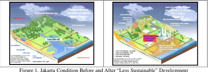
On the other hand, Jakarta Metro Region faces unsustainable urban issues such as: very high population growth, urban sprawling and land speculation. Further, the Region also experiences traffic jams, floods, reduction of green open space, environmental degradation, and urban slums due to less stringent development control. These phenomena were common in other Metropolitan in Developing Countries.
Figure 1. Jakarta Condition Before and After “Less Sustainable” Development Source: Dardak, H. and Poerwo, I.F. Directorate of Spatial Planning, Public Works Department (2007), Dissemination of Act no 26 Year 2007 on Spatial Planning
(Undang-Undang No. 26 Tahun 2007 tentang Tata Ruang)
THE SUSTAINABLE URBAN SPATIAL IMPROVEMENT
PROGRAM IN JAKARTA
Based on the Less Sustainable Development issues of Jakarta, a program named Sustainable Urban Spatial Improvement Program or SUSIP (in Indonesian
language: Program Peningkatan Kualitas Tata Ruang/ P2KTR) was proposed. The
purposes of the program were:
1. To improve the spatial quality of Greater Jakarta Metro Region with community participation;
2. To increase the community awareness and participation in improving the environmental quality of their city
A. for protecting the critical land in the upstream B. for providing regional open spaces in midstream
C. and for mitigating the flood with non-structured measures in downstream of Jakarta Metro Region
3. To provide employment and opportunities in the global economic crisis (as fiscal stimulus in 2009).
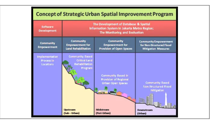
Figure 2. Concept of Sustainable Urban Spatial Improvement Program
Source: Directorate of Spatial Planning, Public Works Department (2009), Sustainable Urban Improvement Program (SUSIP) - Executive Presentation
The SUSIP was translated in several programs such as: Software Development, Community Empowerment and Implementation Process in the locations. The Software Development of SUSIP was later implemented in 2 sub-programs, The Development of Database and Spatial Information System in Jakarta Metro Region and The Monitoring and Evaluation Program for SUSIP local implementation.
Further, eight communities in the eight locations were empowered to conduct the three SUSIP’s strategies of protecting the critical land in the upstream, providing regional open spaces in midstream and mitigating the flood with non-structured measures. The eight communities were assisted by 8 professional consultants in the process that are selected by Directorate General of Spatial Planning, Ministry of Public Works. Integrated Planning and Design approach was introduced in SUSIP process integrating the macro, mezzo and micro approach as described in Figure 3.
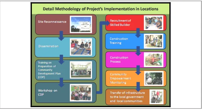
The project was conducted between August and December 2009, with general methodology as followed: Preparation (Workshop for TOR Preparation); Project Tender; Implementation (Participatory Planning, Design and Construction); Monitoring and Evaluation; and lastly Knowledge Management and Dissemination Seminar with various stakeholders
For detail SUSIP implementations steps were proposed: Site Reconnaissance; Program Introduction; Training on Preparation of Community Development Plan (CDP); CDP Workshop; Recruitment of Skilled Builder; Construction Training; Construction Process; Community Empowerment Monitoring; and Transfer of Infrastructure to the Local Government and Local Communities.
Arte-Polis 4 Intl Conference - Creative Connectivity and the Making of Place: Living Smart by Design 4
Figure 3. Integrated Planning & Implementation Strategy Introduced in Sustainable Urban Spatial Improvement Program
Source: Directorate of Spatial Planning, Public Works Department (2009), Sustainable Urban Improvement Program (SUSIP) - Executive Presentation
Figure 4. Methodology of Sustainable Urban Spatial Improvement Program Source: Directorate of Spatial Planning, Public Works Department (2009), Sustainable Urban
Improvement Program (SUSIP) - Executive Presentation
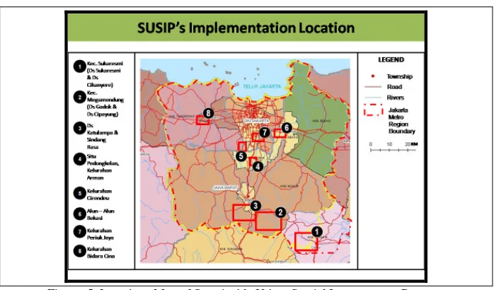
Figure 5. Locations Map of Sustainable Urban Spatial Improvement Program Source: Directorate of Spatial Planning, Public Works Department (2009), Sustainable Urban
Spatial Improvement Program (SUSIP) - Executive Presentation
SUSIP’S BEST PRACTICE CASE STUDY IN CIRENDEU
The Cirendeu Administration (Kelurahan Cirendeu) area is located in South Tangerang Municipality, Banten Province, within the Jakarta Metro Region. The South Tangerang Administration was previously under the Tangerang Regency, and it was just formed in 2009. The implementation of the program was assisted by PT. Rifa Bestari. The purpose of Cirendeu Program was to provide regional open space for communities in the mid-stream areas of Jakarta Metro Region and prepared to reduce the run-off from the surrounding residential land to Pesanggrahan River.
MACRO LEVEL ANALYSIS
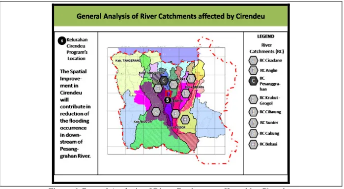
The Cirendeu is located in the South Tangerang and the Pesanggrahan River Catchment. This catchment actually contributes to the flooding in North Jakarta Metro Region. On the other hand, the area is very essential in the preservation of Muara Angke Conservation Area in North Jakarta.
The River Pesanggrahan Catchment (with area of 17.737 Ha) areas was facing rapid land conversion. And more than 60% of the Pesangrahan Catchment was reported as the built up area. This actually created high run-off volume causing extreme flooding in the Pesanggrahan River estuary. This phenomenon was driven by extensive land development in Bogor, Depok, Pondok Cabe, Kebayoran Lama, Cileduk, Kebon Jeruk and Srengseng di West Jakarta. And 38.43% of area of the River Catchment was the residential land use. On the other hand, only 7% of the River Catchment was green open spaces, including the Srengseng Urban Forest.
Arte-Polis 4 Intl Conference - Creative Connectivity and the Making of Place: Living Smart by Design 6
6 retention ponds in Pesanggrahan Cathcment has increased the flood impact in the downstream. This actually made the implementation of the program more crucial for flood reduction and increasing the green open space ratio in Jakarta Metro Region.
Figure 6.General Analysis of River Catchments affected by Cirendeu
Source: Directorate of Spatial Planning, Public Works Department (2009), Sustainable Urban Spatial Improvement Program (SUSIP) - Executive Presentation
MEZZO LEVEL ANALYSIS
In the Mezzo level, The Cirendeu area was also largely converted to residential land. This was initially caused by issue of Government plan developing Commercial Centre in Pondok Cabe (Southern of Cirendeu) and improving Cirendeu’s Major Arterial in to a Semi-Expressway. The land speculations happened and followed by constructions of numbers of residential clusters. This further reduced the green open spaces and water bodies in the area. While the reduction of open space actually correlated with increase of runoff of the area and the potential of local inundation as well as the flood occurrences in the downstream.
Cirendeu Open Space has become a very important facility to the Community living here. They usually use the Cirendeu Open Space for public sport, cultural festival, school playground, etc. So this open space is a liveable public space. And our program purposes are for improving the spatial quality, as well as the maintaining the open space sustainable.
MICRO LEVEL ANALYSIS
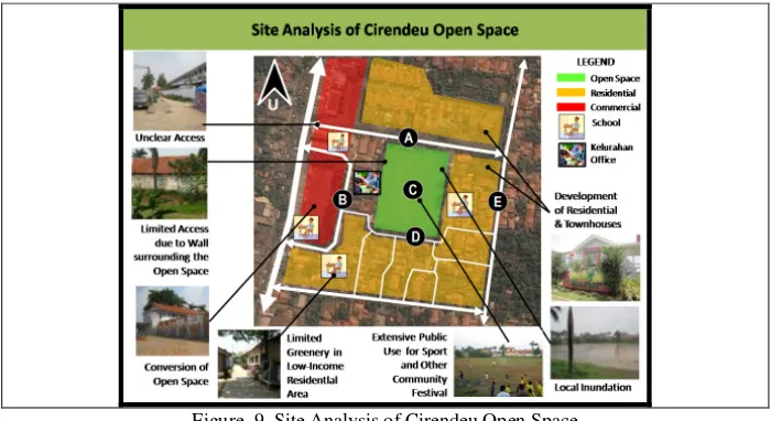
On the other hand, limited access, absence of good drainage system and limited funding of the Local Government must be solved with excellent partnership with the Consultants, Communities as well as other Stakeholders. Lastly, the presence of Low-Income Communities could be assisted with SUSIP program.
Figure 9. Site Analysis of Cirendeu Open Space
Source: PT. Rifa Bestari, Final Presentation for Sustainable Urban Spatial Improvement Program (SUSIP) SF-07 in Cirendeu, Ciputat, South Tangerang Municipality, Banten
Province, Jakarta Metro Region, Republic of Indonesia.
THE IMPLEMENTATION PROCESS
The implementation of SUSIP in Cirendeu faced great challenges due to limited times and the changing program location. But it still succeeded with the following process:
1. Site Reconnaissance and New Site Selection
2. Program Introduction was conducted in several level, such as:
A. Meeting with The Local Municipality (comprising the Public Works Local Agency, Environmental Local Agency, Park and Sanitation Local Agency as well as East Ciputat District)
B. Meeting with Local Community level.
Due to many stakeholders involved more times were needed to be able to communicate the advantages of the Program to the parties.
3. The Training on Preparation of CDP was conducted in 3 sub-stage such as: A. Forming of Local Organisation for implementing SUSIP
B. Focus Group Discussion with Ibu Harini Bambang Wahono, an Activist in Environmental Management (Solid Waste Management and Greening the “Urban Village”) from Banjarsari, Jakarta
C. Training on CDP Preparation (Focus Group Discussion, Participatory Mapping, Designing Open Space as well as preparing the Construction Plan and Cost)
4. The Workshop on CDP was conducted with similar methods of the Training (Focus Group Discussion, Mapping, Landscape Design and Plants Selection, Drainage Design)
Arte-Polis 4 Intl Conference - Creative Connectivity and the Making of Place: Living Smart by Design 8
6. Community Empowerment Monitoring was conducted by other Consultant to ensure the quality of the work.
7. Transfer of Infrastructure to the Local Government and Local Communities; and Stakeholders’ Partnership Discussion were conducted in December.
THE COMMUNITY DEVELOPMENT PLAN AND SMART
DESIGN
The Cirendeu Community prepared the CDP with assistance of the consultant. The CDP actually prescribed strategies to be implemented such as:
1. Improving the ecological, economical, social and thermal comfort with development of the Open Space;
2. Maintaining the existing Open Spaces including the Football Field and private open spaces;
3. Development and optimization of Open Space to be a Green Open Space in
A. Football Field
B. School Playground and Office
C. Local roads and small access within the informal settlement D. Parking area
E. House front and back yard;
4. Creating community activities in the Open Space.
PT. Rifa Bestari provided excellent design options for Local Community to discuss and select. This actually showed the positive aspect involving professional consultants in the Community Based Program. The Landscape Design of Cirendeu Open Space was planned with 3 zones as mentioned in CDP, which are: the Core Zone, the Supporting Zone, and the Transition Zone. This was initially determined due to phasing stage and sustainability of SUSIP development. Further several design concept would be presented in the following figures:
Figure 10. Design Concept of Cirendeu Open Space (1)
Figure 11. Design Concept of Cirendeu Open Space (2)
Figure 12. Design Concept of Cirendeu Open Space (3)
Source: PT. Rifa Bestari, (2009) Final Presentation for Sustainable Urban Spatial Improvement Program (SUSIP).
THE SUSIP’S IMPLEMENTATION
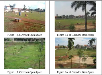
The implementation of planting and construction in Cirendeu could be completed with good construction and landscape work quality. The Community response were found very supportive. This was caused by intensive and participative approach by PT Rifa Bestari. The landscape design were first discussed and constructed among the community. And because of that the Cirendeu Open Space was used for the Public Dissemination of SUSIP in Jakarta Metro Region in March 2010. The construction process also involved at least 200 persons who live nearby the open space. And the results presented in Figure 13-16.
Figure 13. Cirendeu Open Space Figure 14. of Cirendeu Open Space
Figure 15. Cirendeu Open Space Figure 16. of Cirendeu Open Space
Arte-Polis 4 Intl Conference - Creative Connectivity and the Making of Place: Living Smart by Design 10
THE CONCLUSION
It can be concluded that improvement of the Open Space was widely supported by the Community because of their needs for space for outdoor activities, greenery improvement within neighbourhood, and flood reduction. The Open Space also could be managed and developed for supporting local economic activities such as in the Culinary Park section.
Further, effective process of SUSIP could be achieved with active participation of Central Government, Province Government, Municipality or Regency Government, Local Government as well as Local Communities. On the other hand, more timeframe (approximately 9 months) would be needed for executing “More Sustainable” SUSIP. Hopefully, the SUSIP implementation in Cirendeu could be replicated in other area.
ACKNOWLEDGMENT
We would like to express our gratitude to
1. The Directorate of Spatial Planning, Ministry of Public Works, Republic of Indonesia;
2. The Relevant Central Government Offices;
3. The Provincial Governments in Jakarta Metro Region; 4. The Municipalities and Regencies in Jakarta Metro Region; 5. The SUSIP Advisory team
6. PT. Rifa Bestari Team
7. The Consultants, Local Communities and Organisations;
BIBLIOGRAPHY
ALKATIRI, Wardah., Jakarta - Bandung Mega Urban Belt A Tale of a Nation Chasing Economic Growth :Social Change and Multidimensional Crisis in the Heart of Indonesia
DIRECTORATE OF SPATIAL PLANNING, MINISTRY OF PUBLIC WORKS (2009), Sustainable Urban Spatial Improvement Program (SUSIP) - Executive Presentation assisted by Green Impact Indonesia
FORD, LARRY R., A Model of Indonesian City Structure, Geographical Review, Vol. 83, No. 4. (Oct., 1993), pp. 374-396., http://links.jstor.org/sici?sici=0016-7428%28199310%2983%3A4%3C374%3AAMOICS%3E2.0.CO%3B2-M MINISTRY OF FORESTRY, DIRECTORATE GENERAL OF LAND
REHABILITATION AND SOCIAL FORESTRY, OFFICE OF CATCHMENTS MANAGEMENT OF CITARUM - CILIWUNG RIVERS (2008), Final Report of Detail Flood Mitigation Plan for Jakarta Metro Region