Open Geospatial Consortium
Date: 2011-12-19
Reference number of this document: OGC 11-116
http://www.opengis.net/doc/ows8-geoprocessing-eo
Category: Public Engineering Report
Editor: Peter Baumann
OGC
®OWS-8 Geoprocessing for Earth Observations
Engineering Report
Copyright © 2011 Open Geospatial Consortium
To obtain additional rights of use, visit http://www.opengeospatial.org/legal/.
Warning
This document is not an OGC Standard. This document is an OGC Public
Engineering Report created as a deliverable in an OGC Interoperability Initiative and is not an official position of the OGC membership. It is distributed for review and comment. It is subject to change without notice and may not be referred to as an OGC Standard. Further, any OGC Engineering Report should not be referenced as required or mandatory technology in procurements.
Document type: OpenGIS® Engineering Report Document subtype: NA
ii Copyright © 2011 Open Geospatial Consortium This document is a deliverable for the OGC Web Services 8 (OWS-8) testbed activity. OWS testbeds are part of OGC's Interoperability Program, a global, hands-on and collaborative prototyping program designed to rapidly develop, test and deliver proven candidate standards or revisions to existing standards into OGC's Standards Program, where they are formalized for public release. In OGC's Interoperability Initiatives,
international teams of technology providers work together to solve specific geoprocessing interoperability problems posed by the Initiative's sponsoring organizations. OGC
Interoperability Initiatives include test beds, pilot projects, interoperability experiments and interoperability support services - all designed to encourage rapid development, testing, validation and adoption of OGC standards.
The OWS-8 sponsors are organizations seeking open standards for their interoperability requirements. After analyzing their requirements, the OGC Interoperability Team
recommend to the sponsors that the content of the OWS-8 initiative be organized around the following threads:
* Observation Fusion
* Geosynchronization (Gsync)
* Cross-Community Interoperability (CCI) * Aviation
More information about the OWS-8 testbed can be found at:
http://www.opengeospatial.org/standards/requests/74
OGC Document [11-139] “OWS-8 Summary Report” provides a summary of the OWS-8 testbed and is available for download:
OGC 11-116
Copyright © 2011 Open Geospatial Consortium iii
License Agreement
Permission is hereby granted by the Open Geospatial Consortium, Inc. ("Licensor"), free of charge and subject to the terms set forth below, to any person obtaining a copy of this Intellectual Property and any associated documentation, to deal in the Intellectual Property without restriction (except as set forth below), including without limitation the rights to implement, use, copy, modify, merge, publish, distribute, and/or sublicense copies of the Intellectual Property, and to permit persons to whom the Intellectual Property is furnished to do so, provided that all copyright notices on the intellectual property are retained intact and that each person to whom the Intellectual Property is furnished agrees to the terms of this Agreement.
If you modify the Intellectual Property, all copies of the modified Intellectual Property must include, in addition to the above copyright notice, a notice that the Intellectual Property includes modifications that have not been approved or adopted by LICENSOR. THIS LICENSE IS A COPYRIGHT LICENSE ONLY, AND DOES NOT CONVEY ANY RIGHTS UNDER ANY PATENTS THAT MAY BE IN FORCE ANYWHERE IN THE WORLD.
THE INTELLECTUAL PROPERTY IS PROVIDED "AS IS", WITHOUT WARRANTY OF ANY KIND, EXPRESS OR IMPLIED, INCLUDING BUT NOT LIMITED TO THE WARRANTIES OF MERCHANTABILITY, FITNESS FOR A PARTICULAR PURPOSE, AND NONINFRINGEMENT OF THIRD PARTY RIGHTS. THE COPYRIGHT HOLDER OR HOLDERS INCLUDED IN THIS NOTICE DO NOT WARRANT THAT THE FUNCTIONS CONTAINED IN THE INTELLECTUAL PROPERTY WILL MEET YOUR REQUIREMENTS OR THAT THE OPERATION OF THE INTELLECTUAL PROPERTY WILL BE
UNINTERRUPTED OR ERROR FREE. ANY USE OF THE INTELLECTUAL PROPERTY SHALL BE MADE ENTIRELY AT THE USER’S OWN RISK. IN NO EVENT SHALL THE COPYRIGHT HOLDER OR ANY CONTRIBUTOR OF
INTELLECTUAL PROPERTY RIGHTS TO THE INTELLECTUAL PROPERTY BE LIABLE FOR ANY CLAIM, OR ANY DIRECT, SPECIAL, INDIRECT OR CONSEQUENTIAL DAMAGES, OR ANY DAMAGES WHATSOEVER RESULTING FROM ANY ALLEGED INFRINGEMENT OR ANY LOSS OF USE, DATA OR PROFITS, WHETHER IN AN ACTION OF CONTRACT, NEGLIGENCE OR UNDER ANY OTHER LEGAL THEORY, ARISING OUT OF OR IN CONNECTION WITH THE IMPLEMENTATION, USE, COMMERCIALIZATION OR PERFORMANCE OF THIS INTELLECTUAL PROPERTY. This license is effective until terminated. You may terminate it at any time by destroying the Intellectual Property together with all copies in any form. The license will also terminate if you fail to comply with any term or condition of this Agreement. Except as provided in the following sentence, no such termination of this license shall require the termination of any third party end-user sublicense to the Intellectual Property which is in force as of the date of notice of such termination. In addition, should the Intellectual Property, or the operation of the Intellectual Property, infringe, or in LICENSOR’s sole opinion be likely to infringe, any patent, copyright, trademark or other right of a third party, you agree that LICENSOR, in its sole discretion, may terminate this license without any compensation or liability to you, your licensees or any other party. You agree upon termination of any kind to destroy or cause to be destroyed the Intellectual Property together with all copies in any form, whether held by you or by any third party. Except as contained in this notice, the name of LICENSOR or of any other holder of a copyright in all or part of the Intellectual Property shall not be used in advertising or otherwise to promote the sale, use or other dealings in this Intellectual Property without prior written authorization of LICENSOR or such copyright holder. LICENSOR is and shall at all times be the sole entity that may authorize you or any third party to use certification marks, trademarks or other special designations to indicate compliance with any LICENSOR standards or specifications.
This Agreement is governed by the laws of the Commonwealth of Massachusetts. The application to this Agreement of the United Nations Convention on Contracts for the International Sale of Goods is hereby expressly excluded. In the event any provision of this Agreement shall be deemed unenforceable, void or invalid, such provision shall be modified so as to make it valid and enforceable, and as so modified the entire Agreement shall remain in full force and effect. No decision, action or inaction by LICENSOR shall be construed to be a waiver of any rights or remedies available to it.
iv Copyright © 2011 Open Geospatial Consortium
Contents
Page1 Introduction ... 1
2 Geo-Processing of Earth Observations ... 2
2.1 Introduction ... 2
2.2 Coverage Model ... 2
2.3 WCS ... 3
2.4 WCPS ... 3
2.5 EO-WCS ... 4
2.6 WPS ... 5
3 OWS-8 Geoprocessing Experiments ... 5
3.1 52 North: WPS ... 5
3.2 EOxServer: WCS, EO-WCS ... 7
3.3 Rasdaman: WCS, WCPS, WPS ... 7
3.3.1 Data sets ... 7
3.3.1.1 5D forecast data ... 7
3.3.1.2 Oil Spill (Gulf of Mexico) ... 9
3.3.1.3 TRMM Rainfall Data: ... 9
3.3.1.4 NDVI / EVI / VI_Quality over Amazon ... 9
3.3.2 Services offered ... 9
3.3.2.1 WCS 2.0 ... 9
3.3.2.2 WCPS 1.0 ... 11
3.3.2.3 WPS 1.0 ... 11
4 Findings ... 12
OGC
®Geo-Processing of Earth Observations Report
1 Introduction
Document contributor contact points
All questions regarding this document should be directed to the editor or the contributors:
Name Organization
Stephan Meissl EOX IT Services GmbH
Peter Baumann Jacobs University Bremen, rasdaman GmbH Bastian Schaeffer Münster University / 52north
Attention is drawn to the possibility that some of the elements of this document may be the subject of patent rights. The Open Geospatial Consortium shall not be held responsible for identifying any or all such patent rights.
2 Copyright © 2011 Open Geospatial Consortium 2 Geo-Processing of Earth Observations
2.1 Introduction
Ad-hoc processing of Earth Observation (EO) data available through online resources is gaining more and more attention. Expected benefits include
More versatile EO data access More convenient EO data access
Consequently, broadened use and exploitation of EO data
An important step towards integration of EO data into automatic chaining and orchestration
More efficient EO data access: indicating the exact desired result and evaluating processing code close to the coverage data source (i.e., on the server) minimizes network traffic, one of today’s critical performance limiting factors.
EO data belong to the class of coverages, i.e., “space/time varying phenomena” as defined in ISO 19123 [5] (see below for a more detailed discussion). Therefore, in OGC the coverage standards apply to EO discovery, access, processing, and exchange. In OWS-8, the following standards have been investigated and put in relation:
Web Coverage Service (WCS)
Web Coverage Service EO Application Profile (EO-WCS) Web Coverage Processing Service (WCPS)
Web Processing Service (WPS)
In the subsections below these standards are briefly introduced.
2.2 Coverage Model
OGC 11-116
Copyright © 2011 Open Geospatial Consortium 3
While ISO 19123 defines a generic, abstract coverage model, the OGC GML Application Schema for Coverages[3] establishes a concrete coverage model which implements ISO 19123 and allows for interoperable implementations, including concise conformance testing. This Application Schema for Coverages is based on GML 3.2.1 [1]; by defining coverage data structures through XML (with XML Schema and Schematron) a clear, un-ambiguous semantics is established which also allows a concise mapping to represent-ations in other data format encodings, such as GeoTIFF.
From the set of coverages defined by ISO 19123 and GML, two coverage subtypes are relevant for EO: RectifiedGridCoverages consist of values assigned to points which are aligned to a grid with equidistant spacing and with a clear positioning in space and time. L1 and higher-level EO products fall into this category. ReferenceableGridCoverages, on the other hand, have an underlying grid which is not bound to this restriction of equidist-ance; random distances between grid lines, as well as curvilinear grid lines, are possible. Typical use cases include L0 EO data.
2.3 WCS
Based on the coverage model outlined, OGC offers service standards for finding, access-ing, and processing of coverages. At the heart is the Web Coverage Service (WCS). WCS actually is not a single standard, but a modular suite of standards. WCS Core [2]
establishes the basic service together with functionality for accessing and
subsettingcoverages; all WCS implementations must conform to this Core. Several extensions add bespoke extra functionality which implementations optionally may offer. Among these extensions are several protocol bindings (currently: GET, POX, and SOAP), service extensions like scaling & interpolation, CRS transformation, a coverage query language, and upload of coverages to a server. Format encoding extensions allow to send and receivecoverages in a number of formats, such as GML, GeoTIFF, JPEG200, NetCDF, and HDF. (Note that, at the time of this writing, not all extensions are already available.)
2.4 WCPS
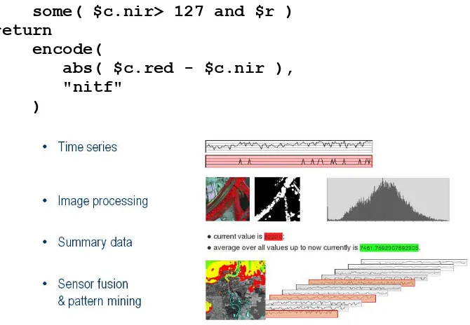
The OGC Web Coverage Processing Service (WCPS) language standard [8]defines a raster query language in the style of SQL and XQuery. This query language allows processing and filtering on multi-dimensional raster coverages1. Figure 1 illustrates some representative use cases. As a concrete example, let us look at the query “From MODIS scenes M1, M2, and M3, the absolute of the difference between red and nir, in HDF-EOS - but only those where nir exceeds 127 somewhere inside region R". In WCPS syntax this is expressed as
4 Copyright © 2011 Open Geospatial Consortium
some( $c.nir> 127 and $r ) return
encode(
abs( $c.red - $c.nir ), "nitf"
)
Figure 1: Representative WCPS use cases.
WCPS is a standalone language specification which, however, is tied into the WCS suite as a “Coverage Processing Extension”. On WPS side, it is linked in as a “Coverage Processing Application Profile”.
2.5 EO-WCS
The OGC Web Coverage Service (WCS) Application Profile – Earth Observation (EO-WCS), defines a profile of WCS 2.0 [OGC 09-110r3] for use on Earth Observation data. An Application Profile bundles several specifications and possibly adds additional requirements on an implementation. Extra requirements can be additions (for example, Dataset Series are introduced by this specification) or constraints (for example, coverages offered are restricted to 2-D rasters).
In terms of EO processing, EO-WCS offers several specific relevant functionalities: A data model extending 2-D EO scenes with a time dimension and EO metadata hierarchical grouping of coverage sets
OGC 11-116
Copyright © 2011 Open Geospatial Consortium 5
2.6 WPS
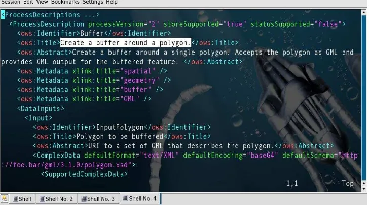
The OGC Web Processing Service (WPS) standard [10] defines a generic method of remotely invoking geoprocessing performed in a server. WPS as such describes processes in terms of their function signature (i.e., input and output parameter types), but does not have any concrete domain semantics associated in a machine readable format like any other OGC Web Service (e.g. Semantics of WMS Layer are also not included in a WMS response) ; Syntactic interoperability is thereby achieved. This behavior keeps it open for any kind of processing. This lack of machine-readable semantics is illustrated in Figure 2: the semantics of function “buffer” is only described by freetext elements title and
abstract.
Figure 2: WPS process semantics described by freetext fields.
Therefore, the WPS standard already suggests to establish focused Application Profiles which restrict themselves to particular domains and functionality classes and achieve semantic interoperability. An example of such an application profile is the WCPS Application Profile for WPS, which has been submitted to the OGC WPS Standards Working Group (WPS.SWG) establishing WCPS as a WPS Application Profile [8], thereby enabling interoperable processing services on coverages.
3 OWS-8 Geoprocessing Experiments
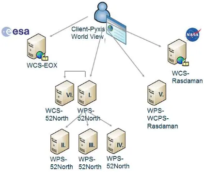
3.1 52 North: WPS
6 Copyright © 2011 Open Geospatial Consortium sent by reference, the WPS resolves these references from the EOX WCS and aggregates them by using a GRASS function in the backend.
The results are served back to the orchestration WPS, which calls the second WPS in the workflow with the results of the first WPS.
Figure 3: WPS orchestration.
This WPS resolves the references for the input data from the first WPS and normalizes them via a Z-Transformation.
OGC 11-116
Copyright © 2011 Open Geospatial Consortium 7
3.2 EOxServer: WCS, EO-WCS
A demonstration of the EO-WCS functionality was provided at the two service endpoints
http://ows.eox.at/cci/ows? and http://ows.eox.at/ofc/ows?. A summary of the available data and some sample requests can be found at http://ows.eox.at. Note that these demonstration services serve data for the OWS-8 demonstration scenarios namely the "Monterey Earthquake emergency response scenario" in the Cross-Community Interoperability (CCI) thread and the "Amazon Drought analysis" scenario in the Observation Fusion – Coverages (OFC) sub-thread.
For the "Amazon Drought analysis" scenario a selected set of products from the
ENVISAT MERIS L1 Full Resolution Full Swath (FRS) collection is offered online and was used in the drought analysis. The selection covers the Amazon area i.e. the spatial bounding box spanning from 10° North to 20° South and 45° West to 80° West with as few clouds as possible. Only images taken in the July, August, September period of 2009 are part of the set. The MERIS data is offered via EO-WCS grouped together into one DatasetSeries.
The second data offered is the FAPAR (Fraction of Absorbed Photosynthetically Active Radiation) band from MERIS Global Vegetation Index (MGVI) L3 products [WR3]. This band is available from the monthly products for July, August, and September in the years from 2006 to 2010 again via EO-WCS grouped together into one DatasetSeries.
Additionally both DatasetSeries are also available via EO-WMS.
The consumption of these datasets both by the WPS services and by the PYXIS client directly was demonstrated successfully in the frame of OWS-8.
3.3 Rasdaman: WCS, WCPS, WPS
A rasdaman database was established with multi-dimensional holdings. The PYXIS client accessed this database.
3.3.1 Data sets
3.3.1.1 5D forecast data
The forecast consists of temperature, height, and windspeed variables, with axes modelTime, pressure, t, x, y.
Sample WCPS query: “initial temperature at model time 0 and surface level”:
for c in ( Temperature_5D )
return encode( (char)((c[ t(0), modelTime(0), pressure(0) ] - 240) * 4), "png" )
8 Copyright © 2011 Open Geospatial Consortium
xmlns:gml=http://www.opengis.net/gml/3.2
xmlns:xsi=http://www.w3.org/2001/XMLSchema-instance
xsi:schemaLocation=http://www.opengis.net/wcs/2.0 ../../wcsAll.xsd
service="WCS" version="2.0.0">
<wcs:CoverageId>u_wind_5D</wcs:CoverageId> <wcs:DimensionTrim>
<wcs:Dimension>x</wcs:Dimension> <wcs:TrimLow>100</wcs:TrimLow> <wcs:TrimHigh>109</wcs:TrimHigh> </wcs:DimensionTrim>
<wcs:DimensionTrim>
<wcs:Dimension>y</wcs:Dimension> <wcs:TrimLow>100</wcs:TrimLow> <wcs:TrimHigh>109</wcs:TrimHigh> </wcs:DimensionTrim>
<wcs:DimensionSlice>
<wcs:Dimension>t</wcs:Dimension> <wcs:SlicePoint>3</wcs:SlicePoint> </wcs:DimensionSlice>
<wcs:DimensionSlice>
<wcs:Dimension>pressure</wcs:Dimension> <wcs:SlicePoint>3</wcs:SlicePoint>
</wcs:DimensionSlice> <wcs:DimensionSlice>
<wcs:Dimension>modelTime</wcs:Dimension> <wcs:SlicePoint>1</wcs:SlicePoint>
OGC 11-116
Copyright © 2011 Open Geospatial Consortium 9
xmlns:xlink="http://www.w3.org/1999/xlink"
xmlns:xsi="http://www.w3.org/2001/XMLSchema-instance" xsi:schemaLocation="http://www.opengis.net/wps/1.0.0
http://schemas.opengis.net/wps/1.0.0/wpsExecute_request.xsd">
<ows:Identifier>petascope.wps.n52.ProcessCoverages</ows:Identifier> <wps:DataInputs> <wps:ResponseForm>
<wps:RawDataOutput mimeType="image/png"> <ows:Identifier>CoverageList</ows:Identifier> </wps:RawDataOutput>
</wps:ResponseForm> </wps:Execute>
3.3.1.2 Oil Spill (Gulf of Mexico)
This 3D (x, y, t) cube contains daily (?) observations of the oil carpet emerging from the “Deepwater Horizon” disaster, and shows how pollution reaches the US coast.
3.3.1.3 TRMM Rainfall Data:
This 3D (x, y, t) cube contains monthly rainfall data.
3.3.1.4 NDVI / EVI / VI_Quality over Amazon
3D (x, y, t) data with a 16 days temporal resolution. Data used in Amazon drought use case scenario.
3.3.2 Services offered
On these above datasets (and further ones), interfaces were established for WCS 2.0, WCPS, and WPS. Below some sample request are reproduced.
3.3.2.1 WCS 2.0
10 Copyright © 2011 Open Geospatial Consortium <?xml version="1.0" encoding="UTF-8"?>
<wcs:GetCapabilities xmlns:xsi="http://www.w3.org/2001/XMLSchema-instance" xmlns:ows=http://www.opengis.net/ows/2.0
xmlns:wcs="http://www.opengis.net/wcs/2.0"
xsi:schemaLocation=http://www.opengis.net/wcs/2.0 ../../wcsAll.xsd
service="WCS"> <ows:AcceptVersions>
<ows:Version>2.0.0</ows:Version> </ows:AcceptVersions>
</wcs:GetCapabilities> DescribeCoverage:
<?xml version="1.0" encoding="UTF-8"?>
<wcs:DescribeCoverage xmlns:xsi=http://www.w3.org/2001/XMLSchema-instance
xmlns:wcs="http://www.opengis.net/wcs/2.0" xmlns:gml="http://www.opengis.net/gml/3.2"
xsi:schemaLocation="http://www.opengis.net/wcs/2.0 ../../wcsAll.xsd" service="WCS" version="2.0.0">
<wcs:CoverageId>TRMM</wcs:CoverageId> </wcs:DescribeCoverage>
GetCoverage 2D:
<?xml version="1.0" encoding="UTF-8"?>
<wcs:GetCoverage xmlns:wcs=http://www.opengis.net/wcs/2.0
xmlns:gml=http://www.opengis.net/gml/3.2
xmlns:xsi=http://www.w3.org/2001/XMLSchema-instance
xsi:schemaLocation=http://www.opengis.net/wcs/2.0 ../../wcsAll.xsd
service="WCS" version="2.0.0">
<wcs:CoverageId>LAND_USE_AMAZON</wcs:CoverageId> <wcs:DimensionTrim>
<wcs:Dimension>x</wcs:Dimension> <wcs:TrimLow>20</wcs:TrimLow> <wcs:TrimHigh>29</wcs:TrimHigh> </wcs:DimensionTrim>
<wcs:DimensionSlice>
<wcs:Dimension>y</wcs:Dimension> <wcs:SlicePoint>1</wcs:SlicePoint> </wcs:DimensionSlice>
OGC 11-116
Copyright © 2011 Open Geospatial Consortium 11
<?xml version="1.0" encoding="UTF-8"?>
<wcs:GetCoverage xmlns:wcs=http://www.opengis.net/wcs/2.0
xmlns:gml=http://www.opengis.net/gml/3.2
xmlns:xsi=http://www.w3.org/2001/XMLSchema-instance
xsi:schemaLocation=http://www.opengis.net/wcs/2.0 ../../wcsAll.xsd
service="WCS" version="2.0.0">
<wcs:CoverageId>radar_base_reflectivity</wcs:CoverageId> <wcs:DimensionTrim>
<wcs:Dimension>x</wcs:Dimension> <wcs:TrimLow>740</wcs:TrimLow> <wcs:TrimHigh>749</wcs:TrimHigh> </wcs:DimensionTrim>
<wcs:DimensionTrim>
<wcs:Dimension>y</wcs:Dimension> <wcs:TrimLow>880</wcs:TrimLow> <wcs:TrimHigh>889</wcs:TrimHigh> </wcs:DimensionTrim>
<wcs:DimensionSlice>
<wcs:Dimension>t</wcs:Dimension> <wcs:SlicePoint>3</wcs:SlicePoint> </wcs:DimensionSlice>
</wcs:GetCoverage>
12 Copyright © 2011 Open Geospatial Consortium 4 Findings
Coverage processing spans a wide field, with frequently varying, if not contradicting, requirements:
From simple access over repeating fixed processing to complex, specialized processes
From ad-hoc, individual one-off requests over repeating parametrized tasks to standing queries
From interactive, exploratory access to routinely invoked, automated tasks
In the context of this discussion it is noteworthy that this query language is restricted in expressive power: it cannot perform recursive or iterated function calls. This restriction is necessary to obtain a language which is “safe in evaluation”, i.e.: every possible request is guaranteed to terminate after a finite number of steps. Well known from database languages, this “security belt” safeguards against a class of Denial of Service attacs. It turns out that the specifications investigated are not competing, but together provide a powerful, versatile Swiss Army Knife to address the complete spectrum of coverage pro-cessing. Notably this is not constrained to EO data in the narrower sense, i.e., satellite im-agery. According to the participants’ experience, this likewise applies, for example, to atmospheric and ocean data.
As a recommendation, service providers may use Table 1 as a decision aid. It consists of the following categories:
Simplicity of use by clients: Important factor in all applications
New Function Effort: Effort for implementing new functionality on the server side
Reusability of existing Functions: Effort for reusing exiting functionality, e.g. algorithms in other programs/formats
Expressive Power: Measurement of how expressive the service protocol is Functional Flexibility: How Flexible is the standard to adapt new requirements Data Flexibility: How Flexible is the standard to use new datasources
OGC 11-116
Copyright © 2011 Open Geospatial Consortium 13
WCS Core + -2 / - - -
WCS extensions o -3 / o o4 -
EO-WCS + - / o5 o -
WCPS6 o … +7 +8 --9 +10 + -
WPS + -11 ++ ++ -12 +
In summary, this can roughly be simplified to the following recommendation for coverage processes:
For comparatively narrowly defined tasks, use WCS Core and Extensions; For ad-hoc processing and filtering where queries are not known in advance, but can be expressed analytically, and data is known and under control of the same service, use WCPS with a host service such as WCS or WPS;
For well-defined processing tasks of algorithmic complexity or for proprietary algorithms and where data source shall be held loosely coupled/flexible as well as for orchestration tasks to shield complexity, use WPS.
2
No changes possible
3
Adding an extension requires server-side programming
4
Only choice is to implement a conformance class or not
5
Functionality is specialized towards satellite image data, but not built, e.g., for 4D/5D atmoslpheric and ocean data
6
Identical in all aspects to WPS Coverage Processing Application Profile
7
Query writing effort depends on task complexity
8
Client phrases new query, no change on server side required
9
Only querys formulated in WCPS can be used. No existing legacy systems/code
10
Expressions of unlimited complexity
11
Changes require server-side programming
12
14 Copyright © 2011 Open Geospatial Consortium 5 References
[1] OGC 07-036, Geography Markup Language (GML) Encoding Standard, version 3.2.1
[2] OGC 10-110r3. OGC® Web Coverage Service 2.0 Interface Standard, version 2.0.0 [3] OGC 10-146r1. OGC® GML 3.2.1 Application Schema for Coverages, version 1.0.0 [4] OGC 11-140. OGC® Web Coverage Service (WCS) Application Profile – Earth
Observation, version 1.0.0
[5] ISO: Geographic Information – coverage geometry and functions. ISO 2005:19123 [6] OGC 07-011, Abstract Specification Topic 6: The Coverage Type and its Subtypes,
version 7.0 (identical to ISO 19123:2005)
[7] OGC 09-146r1.OGC® WCS 2.0 Core Interface Standard, version 2.0.0
[8] OGC 08-068r2. Web Coverage Processing Service (WCPS) Interface Standard, version 1.0.0
[9] OGC 09-045. OGC 11-116(WPS) - OWS-8 Geoprocessing for Earth Observations
Engineering Report, version 0.2.0