Open Geospatial Consortium
Publication Date: 2014-07-14
Approval Date:2014-06-14
Posted Date:2014-05-21
Reference number of this document:OGC 14-000
Reference URL for this document: http://www.opengis.net/doc/ER/testbed10/gml-for-aviation-conformance
Category: Public Engineering Report
Editor:R. Martell
Testbed 10 Engineering Report: GML for Aviation
Conform-ance Testing
Copyright © 2014 Open Geospatial Consortium.
To obtain additional rights of use, visit http://www.opengeospatial.org/legal/.
Warning
This document is not an OGC Standard. This document is an OGC Public Engi-neering Report created as a deliverable in an OGC Interoperability Initiative and is not an official position of the OGC membership. It is distributed for review and comment. It is subject to change without notice and may not be referred to as an OGC Standard. Further, any OGC Engineering Report should not be referenced as required or mandatory technology in procurements.
Document type: OGC® Engineering Report Document subtype: NA
Abstract
This activity is part of OGC Testbed 10. The aviation thread was focused on developing and demonstrating the use of the Aeronautical Information Exchange Model (AIXM) and the Flight Information Exchange Model (FIXM), building on the work accomplished in prior testbeds to advance the applications of OGC Web Services standards in next gen-eration air traffic management systems to support European and US aviation moderniza-tion programs
This document summarizes technical work relating to the enhancement of the GML 3.2.1 conformance test suite in accord with the requirements in the OWS-10 RFQ, Annex B1,
section 6.3.6: “GML for Aviation Compliance Test Suite + GML for Aviation Conform-ance Testing ER”. The essential aim is to advance compliance with respect to the use of GML geometry representations in aviation (AIXM) data.
Keywords
Ogcdoc, ogc document, ows10, aviation, aixm, gml, iso 19107
OGC 14-000
Copyright © 2014 Open Geospatial Consortium. iii
License Agreement
Permission is hereby granted by the Open Geospatial Consortium, ("Licensor"), free of charge and subject to the terms set forth below, to any person obtaining a copy of this Intellectual Property and any associated documentation, to deal in the Intellectual Property without restriction (except as set forth below), including without limitation the rights to implement, use, copy, modify, merge, publish, distribute, and/or sublicense copies of the Intellectual Property, and to permit persons to whom the Intellectual Property is furnished to do so, provided that all copyright notices on the intellectual property are retained intact and that each person to whom the Intellectual Property is furnished agrees to the terms of this Agreement.
If you modify the Intellectual Property, all copies of the modified Intellectual Property must include, in addition to the above copy-right notice, a notice that the Intellectual Property includes modifications that have not been approved or adopted by LICENSOR. THIS LICENSE IS A COPYRIGHT LICENSE ONLY, AND DOES NOT CONVEY ANY RIGHTS UNDER ANY PATENTS THAT MAY BE IN FORCE ANYWHERE IN THE WORLD.
THE INTELLECTUAL PROPERTY IS PROVIDED "AS IS", WITHOUT WARRANTY OF ANY KIND, EXPRESS OR IMPLIED, INCLUDING BUT NOT LIMITED TO THE WARRANTIES OF MERCHANTABILITY, FITNESS FOR A PARTICULAR PURPOSE, AND NONINFRINGEMENT OF THIRD PARTY RIGHTS. THE COPYRIGHT HOLDER OR HOLDERS INCLUDED IN THIS NOTICE DO NOT WARRANT THAT THE FUNCTIONS CONTAINED IN THE INTELLECTUAL PROPERTY WILL MEET YOUR REQUIREMENTS OR THAT THE OPERATION OF THE INTELLECTUAL PROPERTY WILL BE
UNINTERRUPTED OR ERROR FREE. ANY USE OF THE INTELLECTUAL PROPERTY SHALL BE MADE ENTIRELY AT THE USER’S OWN RISK. IN NO EVENT SHALL THE COPYRIGHT HOLDER OR ANY CONTRIBUTOR OF
INTELLECTUAL PROPERTY RIGHTS TO THE INTELLECTUAL PROPERTY BE LIABLE FOR ANY CLAIM, OR ANY DIRECT, SPECIAL, INDIRECT OR CONSEQUENTIAL DAMAGES, OR ANY DAMAGES WHATSOEVER RESULTING FROM ANY ALLEGED INFRINGEMENT OR ANY LOSS OF USE, DATA OR PROFITS, WHETHER IN AN ACTION OF CONTRACT, NEGLIGENCE OR UNDER ANY OTHER LEGAL THEORY, ARISING OUT OF OR IN CONNECTION WITH THE IMPLEMENTATION, USE, COMMERCIALIZATION OR PERFORMANCE OF THIS INTELLECTUAL PROPERTY. This license is effective until terminated. You may terminate it at any time by destroying the Intellectual Property together with all copies in any form. The license will also terminate if you fail to comply with any term or condition of this Agreement. Except as provided in the following sentence, no such termination of this license shall require the termination of any third party end-user subli-cense to the Intellectual Property which is in force as of the date of notice of such termination. In addition, should the Intellectual Property, or the operation of the Intellectual Property, infringe, or in LICENSOR’s sole opinion be likely to infringe, any patent, copyright, trademark or other right of a third party, you agree that LICENSOR, in its sole discretion, may terminate this license with-out any compensation or liability to you, your licensees or any other party. You agree upon termination of any kind to destroy or cause to be destroyed the Intellectual Property together with all copies in any form, whether held by you or by any third party.
Except as contained in this notice, the name of LICENSOR or of any other holder of a copyright in all or part of the Intellectual Prop-erty shall not be used in advertising or otherwise to promote the sale, use or other dealings in this Intellectual PropProp-erty without prior written authorization of LICENSOR or such copyright holder. LICENSOR is and shall at all times be the sole entity that may author-ize you or any third party to use certification marks, trademarks or other special designations to indicate compliance with any LICENSOR standards or specifications.
This Agreement is governed by the laws of the Commonwealth of Massachusetts. The application to this Agreement of the United Nations Convention on Contracts for the International Sale of Goods is hereby expressly excluded. In the event any provision of this Agreement shall be deemed unenforceable, void or invalid, such provision shall be modified so as to make it valid and enforceable, and as so modified the entire Agreement shall remain in full force and effect. No decision, action or inaction by LICENSOR shall be construed to be a waiver of any rights or remedies available to it.
Contents
Page1 Introduction ... 1
1.1 Scope ... 1
1.2 Document contributor contact points ... 1
1.3 Revision history ... 1
4.2 Document references ... 3
5 Overview ... 3
6 Test assertions ... 5
6.1 Valid CRS reference ... 5
6.2 Valid coordinates ... 5
6.3 Valid envelope positions ... 6
6.4 Curve segments ... 6
6.5 Surface boundary (components) ... 6
6.6 Surface boundary (topology) ... 6
6.7 Surface orientation ... 7
7 Test execution ... 7
7.1 Web interface ... 7
7.2 REST API ... 8
8 Test results (Donlon data set) ... 9
8.1 validateMetadataProperties test ... 9
8.2 verifyFeatureMemberProperties ... 10
8.3 validSurfaceBoundary test ... 10
8.4 validSurfaceOrientation test ... 11
Figures
Page Figure 1: Geometry type coverage ... 4Figure 2: Sources of test assertions ... 4
OGC® Engineering Report OGC 14-000
Copyright © 2014 Open Geospatial Consortium. 1
Testbed 10 Engineering Report: GML for Aviation
Conformance Testing
1 Introduction
1.1 Scope
This document summarizes the work undertaken to extend the GML 3.2.1 conformance test suite in order to validate geometry representations that may appear in aviation (AIXM) data sets. Guidelines regarding the use of GML geometry elements in AIXM elements are presented in OGC 12-028, Guidance and Profile of GML for use with Avia-tion Data. These additional constraints are incorporated within the abstract test cases de-scribed in clause 6 and implemented in the GML validator.
1.2 Document contributor contact points
All questions regarding this document should be directed to the editor or the contributors:
Name Organization
R. Martell Galdos Systems, Inc.
1.3 Revision history
Date Release Editor Primary clauses modified
Description
2014-01-31 Initial Draft R. Martell All Initial draft.
2014-04-15 Final Draft R. Martell 5, 8 Final draft for review.
2014-04-30 Final R. Martell 7 Added description of REST API.
2014-05-08 Final (corr.) R. Martell 8.1 Deleted comment about invalid metadata prop-erty value.
1.4 Forward
Recipients of this document are requested to submit, with their comments, notification of any relevant patent claims or other intellectual property rights of which they may be aware that might be infringed by any implementation of the standard set forth in this doc-ument, and to provide supporting documentation.
2 References
The following documents are referenced in this document. For dated references, subse-quent amendments to, or revisions of, any of these publications do not apply. For undated references, the latest edition of the normative document referred to applies.
ISO 19107:2003, Geographic information — Spatial schema.
OGC 07-036, OpenGIS® Geography Markup Language (GML) Encoding Standard (also published as ISO 19136:2007).
OGC 12-028, Guidance and Profile of GML for use with Aviation Data.
3 Terms and definitions
For the purposes of this report, the definitions specified in Clause 4 of the GML Encod-ing Standard [OGC 07-036] and in ISO 19107 shall apply. In addition, the followEncod-ing terms and definitions apply.
3.1
abstract test case
generalized test for a particular requirement [ISO 19105:2000, 4.1]
3.2
conformance
fulfilment of specified requirements [ISO 19105:2000, 4.7]
3.3
executable test case
specific test of an implementation to meet particular requirements [ISO 19105:2000, 4.13]
3.4
OGC 14-000
Copyright © 2014 Open Geospatial Consortium. 3
[ISO 19105:2000, 4.14]
4 Conventions
4.1 Abbreviated terms
AIXM Aeronautical Information Exchange Model ATS Abstract Test Suite
ETS Executable Test Suite
GML Geography Markup Language
URI Uniform Resource Identifier
URN Uniform Resource Name
4.2 Document references
References to parts of documents may take the form of URN values. For OGC documents the syntax specified in OGC 09-047r3 is adopted. To reference parts of ISO standards the scheme specified in RFC 5141 is used.
EXAMPLE urn:iso:std:iso:19136:clause:9.10,10.1.3.2
5 Overview
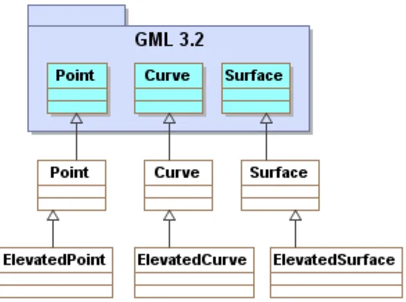
The test development work focused on validating geometry representations commonly appearing in AIXM 5.1 data sets that adhere to the AIXM-GML profile (OGC 12-028). In particular, tests were developed for the following GML and AIXM geometry elements:
– gml:Point (aixm:Point, aixm:ElevatedPoint) – gml:Curve (aixm:Curve, aixm:ElevatedCurve) – gml:OrientableCurve
– gml:CompositeCurve
– gml:Surface (aixm:Surface, aixm:ElevatedSurface)
NOTE The following curve segments are included in the AIXM-GML profile: gml:ArcByCenterPoint, gml:CircleByCenterPoint, gml:Arc, gml;Circle,
gml:GeodesicString, gml:Geodesic, gml: LineStringSegment.
Figure 1: Geometry type coverage
The fundamental goal was to extend the existing GML 3.2.1 conformance test suite to perform more thorough checking that goes beyond schema validation. The test assertions were gleaned from the documents identified in Figure 2, where a dependency relationship is depicted as a dashed line with an open arrow.
OGC 14-000
Copyright © 2014 Open Geospatial Consortium. 5
The new tests were added to the org.opengis.cite.iso19136.data.spatial
package, which contains the classes listed below2.
– PointTests
A geometry (or envelope) element must have a known CRS reference; the value of the srsName attribute is an absolute URI for which one of the following conditions is true:
1. it identifies a "well-known" CRS definition (Note 1), or 2. it refers to a CRS definition.
NOTE The 'urn' or 'http' URI schemes may be used to identify a CRS in accord with
OGC 09-048r3 (e.g. "urn:ogc:def:crs:EPSG::4326").
A geometry element (but not an envelope) may inherit its CRS reference from a broader spatial context. If a geometry element does not explicitly carry the srsName attribute, then it shall be effectively inherited from either:
a. the nearest ancestor geometry (aggregate) that has the srsName attribute, or b. the gml:boundedBy/gml:Envelope element in the containing feature instance. The source documents are listed below.
– urn:ogc:doc:dp:12-028:clause:3.2
– urn:iso:std:iso:19136:clause:9.10,10.1.3.2 – urn:iso:std:iso:19107:clause:6.2.2.17
6.2 Valid coordinates
A geometry (or envelope) element must satisfy all of the following conditions: 1. length of coordinate tuple = CRS dimension
2. it lies within (is covered by) the valid area of the associated CRS
NOTE The last constraint will serve to detect obvious cases where the axis order is incorrect (for example, a position expressed in EPSG 4326 as -122.22, 50.55).
The source documents are listed below. – urn:iso:std:iso:19107:clause:6.2.2.10
6.3 Valid envelope positions
The coordinates of the lower corner must be less than the coordinates of the upper corner, where the coordinate tuples are compared item by item: lowerCorner < upperCorner. The source documents are listed below.
– urn:iso:std:iso:19136:clause:10.1.4.6 – urn:iso:std:iso:19107:clause:6.4.3.2,6.4.3.3
6.4 Curve segments
A curve must satisfy all of the following conditions: 1. the curve has one or more segments;
2. the segments are contiguous (end point of each segment except the last being the start point of the next).
The source documents are listed below. – urn:iso:std:iso:19136:clause:10.4.5 – urn:iso:std:iso:19107:clause:6.3.16.1
6.5 Surface boundary (components)
Each ring composing the boundary of a surface must be: 1. simple (does not self-intersect);
2. closed (forms a cycle such that the ends are identical). The source documents are listed below.
– urn:iso:std:iso:19136:clause:10.5.11.1 – urn:iso:std:iso:19107:clause:6.3.6
6.6 Surface boundary (topology)
Each interior ring must be covered by the surface delimited by the exterior boundary (if it exists). The rings may touch at a tangent point.
OGC 14-000
Copyright © 2014 Open Geospatial Consortium. 7
– urn:iso:std:iso:19107:clause:6.3.7.2
6.7 Surface orientation
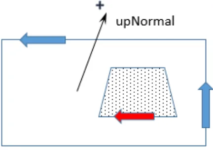
A surface has an "up" direction in terms of the upward (positive) normal, which is the side of the surface from which the exterior boundary appears counterclockwise and inte-rior boundaries are traversed in a clockwise manner. In essence, the inteinte-rior is always to the left of a boundary curve (Figure 3).
The source documents are listed below: – urn:iso:std:iso:19136:clause:10.5.5
– urn:iso:std:iso:19107:clause:6.3.17.1,6.4.33.2
7 Test execution
7.1 Web interface
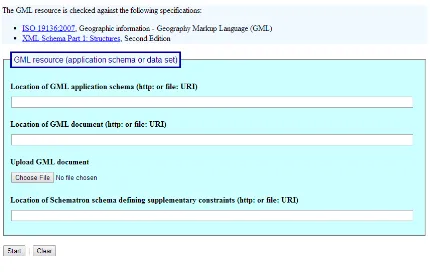
The geometry tests were implemented as extensions of the GML 3.2.1 conformance test suite. The suite may be run using the official OGC test harness, TEAM-Engine 4.0. The OGC maintains a testing facility that provides access to the latest test suites at this loca-tion: <http://cite.opengeospatial.org/te2/>.
The interface provided by the TEAM-Engine web application presents a form wherein the location of the instance document to be validated is specified by an absolute URI val-ue. Alternatively, the GML document may be uploaded for validation (Figure 4).
Figure 4: Test execution (web interface)
7.2 REST API
A REST API provides an alternative means of executing the test suite by submitting a GET request to the test controller endpoint. The test run arguments are summarized in Table 1. The Obligation descriptor can have the following values: M (mandatory), O (op-tional), or C (conditional).
Table 1 — Test run arguments
Name Type Obligation Description
xsd URI C (required if ‘gml’ is not supplied)
Refers to a GML application schemaa
gml URI C (required if ‘xsd’ is not supplied)
Refers to a representation of a GML data instancea
sch URI O Refers to a Schematron schemab
a. Ampersand ('&') characters appearing within a query parameter value must be percent-encoded as %26.
OGC 14-000
Copyright © 2014 Open Geospatial Consortium. 9
The request URI has the following form (substitute the appropriate host name and port number for the actual test harness):
http://host:port/teamengine/rest/suites/gml/3.2.1-r15/run?gml=uri
where uri is an absolute URI that refers to the instance document to be validated; the ‘http’ and ‘file’ URI schemes are acceptable. The result entity is an XML document with
<testng-results> as the document element.
8 Test results (Donlon data set)
The test suite was run against the latest “Donlon” data set (updated on 2014-03-19). Sev-eral assertion errors were reported; these are summarized below along with suggestions for resolving the errors.
8.1 validateMetadataProperties test
Property value has minOccurs = 0. Property type definition must contain the @xlink:href attribute:
{http://www.aixm.aero/schema/5.1}FeatureMetadataPropertyType
The type definition is listed below (the particle cardinality constraint is highlighted).
<complexType name="FeatureMetadataPropertyType"> <complexContent>
<extension base="gml:AbstractMetadataPropertyType">
<sequence minOccurs="0">
Since the xs:sequence model group has minOccurs="0", the @xlink:href attribute decla-ration is expected so as to allow for a remote value; it is an error if a non-nillable property has no value. If the intent is to permit only in-line content (i.e. a child element), then this minOccurs constraint should be removed, since the property declaration itself already has minOccurs="0".
<complexType name="AbstractAIXMFeatureType" abstract="true"> <complexContent>
<extension base="aixm:AbstractAIXMFeatureBaseType"> <sequence>
<element name="featureMetadata"
type="aixm:FeatureMetadataPropertyType" minOccurs="0"/>
This issue applies to all of the base metadata property types defined in the AIXM namespace (see schema AIXM_AbstractGML_ObjectTypesFeatures.xsd):
FeatureMetadataPropertyType
FeatureTimeSliceMetadataPropertyType
MessageMetadataPropertyType
8.2 verifyFeatureMemberProperties
Expected sequence compositor in non-empty property type
{http://www.aixm.aero/schema/5.1/message}BasicMessageMemberAIXMPropertyType This property type definition uses the xs:choice compositor:
<complexType name="BasicMessageMemberAIXMPropertyType"> <complexContent>
<extension base="gml:AbstractFeatureMemberType">
<choice>
<element ref="aixm:AbstractAIXMFeature"/>
</choice>
<attributeGroup ref="gml:AssociationAttributeGroup"/> </extension>
</complexContent> </complexType>
However, there is really no choice here and the GML property type patterns that must be adhered to (see ISO 19136, cl. 7.2.3) all use the xs:sequence compositor.
8.3 validSurfaceBoundary test
In GML ring: Failed to unmarshal GML geometry from resource at urn:uuid:6118ba76-0d46-4ba7-af63-17f29755e890
There is no standard mechanism for resolving a URN (Uniform Resource Name). The URN value occurs in a gml:curveMember property that refers to a boundary component of the geometry element aixm:Surface[@gml:id="ID_11364"]:
<gml:curveMember xlink:href="urn:uuid:6118ba76-0d46-4ba7-af63-17f29755e890" xlink:title="along the State border"/>
Inserting the referenced curve geometry would be the simplest means of fixing the error. Note that as stated in ISO 19136, cl. 8.1 it is an error if a GML property value cannot be dereferenced:
OGC 14-000
Copyright © 2014 Open Geospatial Consortium. 11
8.4 validSurfaceOrientation test
Exterior boundary of surface with @gml:id='SFIRAMSWELL' is not oriented CCW with respect to the up-normal.
The fix here is to just reverse the orientation of the constituent curve member,
gml:Curve[@gml:id="CFIRAMSWELL"]. The coordinate list (gml:posList) indicates a clockwise ordering.
<gml:Curve gml:id="CFIRAMSWELL"> <gml:segments>
<gml:GeodesicString>
<gml:posList>57.0833333333333 -40.0 56.6666666666667 -21.1333333333333
43.5166666666667 -21.1333333333333
41.4 -30.05 40.7333333333333 -37.1833333333333 42.6 -37.0 44.0333333333333 -40.0 48.4666666666667
-41.3333333333333 52.85 -41.7833333333333 57.0833333333333 -40.0</gml:posList>
</gml:GeodesicString> </gml:segments>