Journal of Theoretical and Applied Information Technology 20th January 2014. Vol. 59 No.2
© 2005 - 2014 JATIT & LLS. All rights reserved.
ISSN: 1992-8645 www.jatit.org E-ISSN: 1817-3195
263
CORRECTION POSITION OF COORDINATES FROM DATA
GPS LOGGER IN GOOGLE MAPS BY USING LAGRANGE
INTERPOLATION METHOD
1NGAKAN MADE SATRYA WIBAWA, 2I MADE SUKARSA and 3I KETUT ADI PURNAWAN
123
Department of Information Technology, Udayana University, Bali, Indonesia
E-mail: [email protected], [email protected], [email protected]
ABSTRACT
Development of navigation technologies increase rapidly. People need a GPS to indicate a location or street. The accuracy of the GPS position is often less precise. This problem is used as a discussion of issues in the design of GIS to fix the GPS coordinates to the coordinates of the path using interpolation polinom lagrange method. This study uses PL/SQL to MySQL engine to perform the calculations haversine formula and interpolation polinom lagrange. Coordinates improvements value obtained from the results of these calculations.
Keywords: GPS, GIS, PL/SQL, Correction Coordinate, Interpolation Polinom Lagrange
1. INTRODUCTION
Kaplan and Christopher define navigation as the science of getting the objects from one place to another [6]. GPS provide accuracy, the position of the object directly, and track in realtime. Hoffmann – Wellenhof et al describe the GPS satellites placed at least five to eight satellites revolve around the earth and can be accessed at any time [3]. In accord with statement by Yun Young-Sun, GPS has many technical and economical benefits for virtually all industries and nowadays many companies are developing GPS enabled applications and navigation system [14].
The popularity of GIS application in mapping numerical information from satellite imagery as to assist for collecting relevant data of landmark in traveling and directions. Google maps is one of the popular digital map that provides many advantages for the research of GIS. Problem of accuracy GPS coordinates will be used as data samples to the next process with GIS application.
GPS has several sources of error that can degrade the level of accuracy from few meters to tens of meters [9]. These error sources are Ionospheric, Atmospheric delays, Satellite and Receiver Clock Errors, Multipath, Dilution of Precision, Selective Availability (S/A) and Anti Spoofing (A-S) as described by Kaplan and Christopher [6].
This paper discusses the GPS coordinates of the error correction in using interpolation
polynomial lagrange method to coordinate road. Error correction has been performed by several researchers, but different in the data processing, the tools used, and the lack of provision for the integration of digital maps. This study utilize the Google API, including digital map and geographic coordinates. Data GPS coordinates (latitude and longitude) were recorded by using a GPS Logger application. This data is stored in a database and processed through lagrange polynomial interpolation calculation by using PL/SQL. Correction results displayed in the form of a comparison of data the GPS coordinates, the coordinates of the reference, and the interpolation results on Google maps.
2. THEORITICAL BACKGROUND
2.1 GPS (Global Positioning System)
GPS is the abbreviation of Global Positioning System that is known as a system for determining the position and global navigation using satellite. The GPS system was originally presented in the 1960s, several U.S. government organizations including the Department of Defense (DOD), the National Aeronautics and Space Administration (NASA) and the Department of Transportaion (DOT), which are interested in developing a satellite system to determine the 3-dimensional position. Surname GPS system that is NAVSTAR GPS (Navigation Satellite Timing and Ranging Global Positioning System).
coverage and data messages to the receiver equipment.Kaplan and Christopher described GPS has three different segments i.e. satellite constellation, ground-control or monitoring network, and user receiving equipment [6]. The GPS constellation which served as a reference points on the earth there are 24 GPS satellites in 6 orbital planes. Each orbit is occupied by 4 satellites with the different intervals. The monitoring network segment is a part of controlling and monitoring every movement of the GPS satellite and signal integrity. The user receiver equipment segment, there is receiver that receive signals from GPS satellite. Receiver signals consist of antenna receiving signal, filtering, amplification circuit, and composition of the tracking signal.
Determining position of GPS is done by measuring the distance simultaneously to multiple satellites. Determination of the coordinates of a point on the earth, the receiver requires at least four satellites with good signal. In general, the position methods. This study uses a GPS logger application with absolute method because it only used for navigational purposes. Some errors in GPS positioning, namely : multipath effects, the effects of selective availability (SA), anti-spoofing, the inaccurate position due to receiver settings are not in accordance with the parameters of GPS. In general, the performance of GPS accuracy depends on the level of measurement noise on the navigation system i.e. measurement accuracy of pseudorange and carrier measurements [12].
2.2 GIS (Geographical Information System) Jean define is a computer based system that is used to capture the image so it can be stored, manipulated, and analyzed for the research of geographic information[5].
Hurvitz stated that GIS have different functionality from other analytical environment is rooted in the spatially explicit nature of the data [4]. Geographic data is divided into four types : points, lines, polygons (or areas), and surfaces. Each data’s type has a particular dimensionality and are associated with a set of descriptive. GIS contains DBMS (database management system) which is used to store descriptive information about points, lines, and areas.
The development of internet makes web-based GIS application services is growing rapidly. The
advantage of using the Maps APIs in GIS is able to display and process the data between raster and vectors data. One of the applications that are used in this study is Google Maps API.
2.3 Google Map
Google Maps API is source code interface that provide program library and service for generating a map over the internet [13]. Google Maps API provides the key API to request spatial data about geographic information and process the map as an object in any external website. Google Maps API also allows to customize the map controls including navigation slide bar, polyline, marker, button to switch between map or aerial and hybrid views.
Google has released and develop a mapping based on web. Google as a leader in the product development map with Google Maps provide a slick, highly responsively visual, detail street and aerial imagery data. Google Maps API has many advantages including the availability of extensive data coverage, open spesification, ease of implementation, dynamic navigation, and querying capability. Google maps api are mainly based on Javascript and eXtensible Markup Language (XML), it enables customize the map interface into existing web sites.
2.4 Polynomial Lagrange Interpolation
Numerical analysis is the branch of mathematics and computer science that proposes, develops, analyzes and applies numerical method for solving all kind problems of mathematical [1]. The interpolation formula are derived which find the interpolated value of a function in terms of certain of its values [11]. Polinom lagrange interpolasi is known as popular method because it uses the function in the form of polynom. If the unknown function is f(x) and census data is n then :
………(15)
Then the calculation of polynomial lagrange interpolation together with two points (x0,f(x0)) and
(x1,f(x1)) as follows:
………….(15)
Can be simplified in a similar manner :
………….(15)
Where a0 = y0, a1 = y1 is longitude form
Journal of Theoretical and Applied Information Technology 20th January 2014. Vol. 59 No.2
© 2005 - 2014 JATIT & LLS. All rights reserved.
ISSN: 1992-8645 www.jatit.org E-ISSN: 1817-3195
265 where x = latitude form coordinate GPS and x0,x1 =
latitude from coordinate road.
2.5 Haversine Formula
The haversine formula is an equation commonly used in navigation which gives great circle distance between two different points on the surface of the sphere (Earth) based on longitudes and latitudes [10].
Then the calculation using haversine formula can be modeled as follows :
…..(8)
These are explanations of haversine formula as below :
d = distance between two points. r = radius of the earth.
Haversine function on the above arguments are in radian. Simplify haversine equation in the form of degrees will make the process faster calculations on database.
Translation to SQL statement in degree : SQRT(POW(69.1*ABS(latitude - lat_obj),2) +
POW(69.1*ABS(long_obj-longitude)*COS(latitude/57.3),2)……(2)
3. SYSTEM OVERVIEW
This section explain about the overview of the error correction, the result calculation of haversine and polynomial lagrange interpolation.
3.1 System Overview
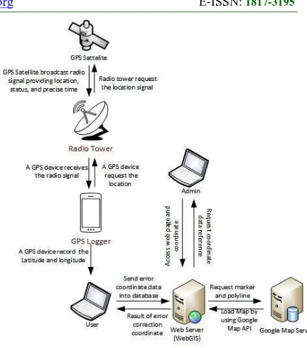
System overview of the process in making the determination of the position of the error correction can be modeled as shown in figure 1.
Figure 1 : System overview
There is general description of the system that is useful to describe the flow system of error correction. These are explanations of system overview on figure 1 as follows :
1) GPS logger request data coordinates location to the radio tower.
2) Radio tower request the location signal to the GPS satellite.
3) GPS satellite broadcast radio signal providing location, status, and precise time to the radio tower.
4) The radio tower invert signal location to GPS logger.
5) GPS Logger application record data coordinate from the radio tower.
6) User use coordinate data from GPS logger to analyze with the coordinate data from the Administrator.
7) Analysis results request polyline and marker from Google Map Server.
8) Web GIS will display result to the user and they can observe the correction points.
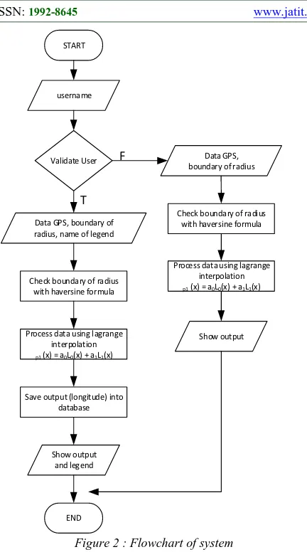
3.2 Design of System
START
Figure 2 : Flowchart of system
First, the user can choose to be a registered user or regular user. Then the user input the data coordinates of GPS logger and select multiple coordinate points within radius. Select multiple points within radius by using haversine formula. Further, interpolation process to calculate the coordinates of the GPS logger, reference, and many points in radius. Interpolation formula is used as
follows : where
latitude (X) and longitude (Y). Interpolation results in the form of a new longitude because interpolation can only process one of the coordinates (longitude only or latitude only).
The following polynomial lagrange interpolation formula in the form of PL/SQL syntax that is divided into 3 function :
1) Function L
IF ISNULL(new_long_obj) THEN SET trace = CONCAT(trace, 'NULL', ' ');
ELSE
SET trace = CONCAT(trace, l(lat_obj, long_obj,
Journal of Theoretical and Applied Information Technology 20th January 2014. Vol. 59 No.2
© 2005 - 2014 JATIT & LLS. All rights reserved.
ISSN: 1992-8645 www.jatit.org E-ISSN: 1817-3195
267 4.1 The Experiment Results
GPS coordinate data that is used around the area of Denpasar and Badung. Data GPS that stored i.e. latitude and longitude by using the assistance GPS logger application. After inputing coordinate data and select the amount of coordinate used, then it processed through haversine formula and polinomial lagrange interpolation is done in MySQL. Google Map is used to display the comparison of data GPS coordinates, road, and results of the interpolation.
For example, if the GPS coordinate data as below :
Table 1 : GPS Coordinate
Latitude Longitude
-8.779101 115.177334
If the user select the amount of coordinates is 3 points, then the following works will be calculated by haversine formula to find the point closest to the GPS coordinates and it uses only 3 coordinate road.
Table 2 : Reference Road Coordinate
latitude Longitude
-8.7791615097 115.1776599884 -8.7783518599 115.1776707172 -8.7782284325 115.1776814461
After the specified coordinates reference data have been determined by haversine formula and calculate by interpolation method as follows :
Table 3 : Interpolation Result
latitude longitude Longitude interpolasi
-8.779101 115.177334 115.17765740396067
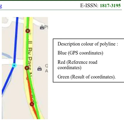
Correction result display on Google Map as figure 3:
Figure 3 : Correction result on Google Maps
4.2 Discussion
The purpose of developing system of error correction GPS coordinates is to correct errors of the coordinate GPS of the coordinate road.
System of error correction coordinates built with the programming language including PHP, AJAX, Javascript, and MySQL.
The first step is to input the data GPS coordinates and select the amount of coordinates. After that, it processes by using haversine formula and polynomial lagrange interpolation which is done in MySQL database. Starts from calculating the closest distance with haversine formula until the calculation with polynomial lagrange interpolation. The correction result shows that the value of interpolation coordinate almost close to the value of coordinates road. However, the results of the correction depends on several factors including the amount of selected coordinates and the exact location of coordinate road.
5. CONCLUSION
In this paper, we discuss the error correction of data GPS coordinate by using the polynomial lagrange interpolation. We try to compare the data GPS coordinates with coordinate road. We founded that there are some the conclusions of the test result as follows :
1) The calculation of the radius of the generate value much beyond the capacity of the data type range that are used as a result reveal null values. 2) If we use a lot of radius point then it is required road points with high density of coordinate road.
Description colour of polyline :
Blue (GPS coordinates)
Red (Reference road coordinates)
3) The optimum radius point that can be used between range 1 and 30 points.
The accuracy of calculation it is due to several factors, including the location coordinates of complete road points and the amount of points within radius. So that can minimize errors in the calculation of interpolation.
REFERENCES:
[1] Alfio Q., Riccardo S., and Fausto S., Numerical Mathematics, New York : Springe-Verlage, 2000.
[2] Dan Moore, “Calculate distances between coordinates efficiently in oracle”, [Online] October 2009. Available at : http://stackoverflow.com/questions/1591323/
how-to-calculate-distances-between-coordinates-efficiently-in-oracle.
[3] Hoffman-Wellenhof, H. Licteneegger, J. Collins, “Global Positiong Systems : Theory & Practice, 4th Edition”, New York/Berlin: Springer-Verlag Wien,1998.
[4] P. Hurvitz, “The GIS Spatial Data Model”, The University of Washington Spatial Technology, [Online] 2004. Available at : http://courses.washington.edu/gis250/lessons/i ntroduction_gis/spatial_data_model.html. [5] Jean and Claude Thill, “Geographic Information
Systems in Transportation Research”, New York : Pergamon, 2000.
[6] Kaplan E (ed), “Understanding GPS: Principles and Applications”, 1st edition (Boston: Artech House), 1996.
[7] Michael E. W., “Harvest Tracking and Navigation With GPS”, Canada, 1999. [8] Nitin R. Chopde, Mangesh K. Nichat.
“Landmark Based Shortest Path Detection by Using A* and Haversine Formula”, G.H. Raisoni College of Engineering and Management, International Journal of Innovative Research in Computer and Communication Engineering, Vol. 1, issue 2, April 2013
[9] Pratap Misra and Per Enge, “Global Positioning System Signals, Measurements, and
Performance”, 1st edition
(Massachusetts:Ganga-Jamuna Press), 2001. [10] Samuel Idowu, Nadeem Bari. “A Development
Framework for Smart City”, Luléa University of Technology International journal of Computer Application, vol 6, 9 Nov 2012.
[11] Srivastava, R.B and Purushottam Kumar Srivastava, “Comparison of Lagrange’s and Newton’s interpolating polynomials”, Journal of Experimental Sciences, Vol. 3, No. 1, pp 01-04, 2012.
[12] S.S.Riaz Ahamed. “The Effect Of Global Positioning System For Reliable Positioning, Navigation and Timing Services”. Department of Computer Applications, Vol 4, No 9, 2005.
[13] T Edwin Chow. “The Potential of Maps APIs for Internet GIS Applications”, Department of earth and resource science university of michigan, Vol 12, No 2, pp 179-191, 2008. [14] Yun Young-sun, Park Sung-min and Kee
Chang-don, “Test of GBAS Integrity Monitoring System Using GPS Simulator,” Wuhan University Journal of Natural Science, Vol. 8, No. 2B, pp 697-704, 2003.