Agricultural Science Research Journal 5(5); pp. 85- 91, May 2015 Available online at http://www.resjournals.com/ARJ
ISSN: 2026 – 6073 ©2015 International Research Journals
Full Length Research Paper
Erosion prediction for determination Soil and water
conservation based local wisdom in Ayung Watershed
Bali, Indonesia
Made Sri Sumarniasih
Doctoral Program of Agricultural Sciences at Post Graduate Program, of Udayana University
Indayati Lanya, I Nyoman Merit, Made Antara Faculty of Agriculture, of Udayana University, Bali, Indonesia
Corresponding Author e-mail: [email protected]
Abstract
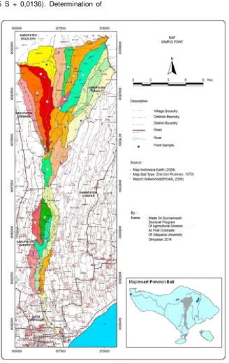
The aim of this research is to prediction of erosion and determination soil and water conservation based local wisdom. Location determination is based on the compilation map Ayung Watershed, map of soil types, land use map and slope map. Uniformity of soil type, slope and land use classes is classified into one unit of land, so there are 40 units of land to be taken sample points. The erosion prediction used USLE method. The results of research showed that the erosion in the Ayung watershed from very light to very heavy ranged from 0.98 to 1717.12 tons/ha/year. Very light and light erosion occurs on Paddy field use and forest, on the Ayung watershed the middle and downstream, from Petang, Bongkasa, Abiansemal, Kesiman, to the south, to the mouth of the river Ayung in Padanggalak. Heavy to very heavy erosion on farm land use mixed-crop, cultivated, and shrub, at the start of the Petang, to the north to the Ayung watershed upstream. Erosion can be tolerated (Edp) ranged from 22.60 to 57.00 tons/ha/year. Suggested erosion control through soil and water conservation efforts based on local wisdom, namely: (a) increasing the density of plants in the mixed-crop of citrus mix with coffee plants with individual terracing and set the time of fertilization to overcome of climate change; (b) cropping pattern corn with legume or horticultural crops cultivated on land use, the addition of crop residues used as mulch or organic material, construction the level terrace or cotour terrace according topography planting crops commonly grown amplifier terraces in the study area, as well as set the time of planting to overcome with climate change; (c) set the time of planting rice in Paddy field based Sasih to overcome climate change so that the distribution of water by a water control system (Subak) running smoothly; (d) planting trees in border river or cliff, then at that location sacred by praying and giving Balinese cloth (cloth poleng or checkered black and white) to put on the tree; (e) regulation form permitting of prohibition or tightening the construction of tourism facilities in the Ayung river border. Erosion in the Ayung watershed decreased to very light with a range of 0.98 to 50.85 tons/ha/year, if carried out crops and land management changes (CP) based on local wisdom (decreased >90%).
Keywords: erosion, conservation, local wisdom
Introduction
Watershed is an area bounded by topography separator that holds stores and drain the rainfall that falls on it flows into a river that empties into the lake or in the ocean (Asdak, 2004; Ministry of Forestry, 1997). Ayung watershed is the longest in Bali, stretching from north to south, tipped in Bangli district, Badung, Buleleng and Tabanan, Gianyar and flows through and empties
The problem that occurs is a reduction in land cover in the upper reaches of the watershed, due to the steep topography used for agriculture crops should be designated catchment area, whereas from the upstream to the middle of the dominant land use and cultivated land and mixed-crop without soil and water conservation treatment. Such conditions can lead to erosion, land degradation, lower land productivity and agricultural production eventually declined to 50% (Suwardjo et al., 1995; Poerbandono et al., 2006). In the middle especially in Gianyar regency, along the banks of the river overlooking the gorge built tourism supporting facilities such as hotels and restaurants that should be protected areas, while in the lower reaches of the Ayung watershed dominant land conversion to residential (BPDAS, 2009). Watershed degradation is accelerated by an increase in the utilization of natural resources as a result of population growth, development pressures, and socio-economic pressures. Efforts to improve the condition of the watershed is the soil and water conservation based on local wisdom, so that the controlled reciprocal relationship of natural resources and environmental watershed by human activities to the preservation of the environment and human welfare.
Local wisdom can be expressed as a science and technology that took place as a human effort at that time to face the challenges of life and good against the natural life, fellow or his beliefs. Local knowledge or local wisdom born, lasting and sustainable as the community in the life and live lihood is highly dependent on the area in which they live. Truth which has been a tradition or awig-awig in an area formed as a local culture of excellence and geographical conditions in a broad sense. Local knowledge is a product of past cultures that should constantly hold onto life and even worth locally, but the values contained in it are considered a very universal. Local knowledge is an individual’s response to its environment, a form of environmental wisdom in the social life somewhere, insight and customs or ethics that guide human behavior in life in an ecological community. Conceptually, local wisdom is human wisdom that rests on the philosophy of values, ethics, and behavior in ways that traditional institutionalized, the value of which is considered good and right, so it can last a long time and even institutionalized in society (Salain, 2007; Ridwan, 2007). The function and meaning of local and water conservation programs is bottom-up approach by involving the community. In Bali there are some areas that local knowledge can be used as a foundation policies in an effort to save the environment, especially in soil and water conservation efforts, namely the manufacture of swales or terraces on farmland to steep topography choppy, set the time of planting Sasih (months according to Balinese calendar) to address
climate change, and the Subak irrigation system to regulate the distribution or the distribution of water in the member (Subak manners). According Windia (2006), Sutrisno (2011)and Ministry of Agriculture (2010), Subak is indigenous Balinese cultural heritage of Bali and has been recognized worldwide, where Paddy field irrigation is managed by an organization that has an important role. Subak irrigation is the management body of water user farmers, an institution that becomes a container grower in the region, which is formed by the ministry of irrigation water user farmers themselves democratically. The irrigation system is done in Subak is a Balinese efficiency based on formal rules, the economic mindset. While the concepts of effectiveness, religious values, and management of irrigation systems based on harmony and togetherness, well organized and flexible system Subak in Bali. Subak as an institution that socio-cultural character has the strength and wisdom of the local culture, which is flexible and able to absorb agricultural technology and absorb the culture that developed in the surrounding community. This situation is expected to address and resolve issues related to the management and provision of farm level irrigation water. New innovations and paradigm changes related to farming and utilization of water resources is expected to be finalized and adopted by Subak system. Local wisdom can be used as a firm foundation in carrying out soil and water conservation activities, and have a noble purpose is to save the environment. The application of local wisdom combined with modern rules is expected to provide optimal results in soil and water conservation erosion, and predict how much reduction in erosion with changes in crop and land management (CP) based local wisdom.
Research Method
(tons/ha/year).R = 6,119 C1,21 D0,47 M0,53(Bols, 1978), where : R = rainfall erosivity, C = monthly rainfall (cm), D = number of monthly rain days, M = maximum rainfall (cm) for 24 hours in the month. K is the soil erodibility value,100 K = 2,292 {2,1 M1,14 (10-4)(12 – a) + 3,25 (b – 2) + 2,5 (C–3)}where, M is (% dust+ % very fine sand ) (100 - % clay) , a is the % organic matter, soil structure is a class b and class c is the permeability of the soil. LS is the value and slope length factor, L is the
(0,00138 S2 + 0,00965 S + 0,0136). Determination of
the value of CP is done with the situation on the ground approach to the research of the Land Research Center of Bogor (Arsyad, 2010), Hammer (1980) and the Ministry of Forestry (2009). Erosion limit value that can be tolerated (Edp) is a value that does not exceed the rate of erosion rate of soil formation. In this study, Edp calculated by the equation of Hammer (1981) namely,
Edp = Soil depth x Depth factor Land used old
Result and Discussion
Erosion Prediction (A) and the Tolerable Erosion (Edp)
The analysis showed erosion in the Ayung watershed from very light to very heavy with a range of 0.98 to 1717.12 tons/ha/year (Table 1). Very light and light erosion occurs on Paddy field land use and forest, heavy to very heavy erosion occurred on the plantation land use mixed-crop, cultivated and shrubs. Very light to light erosion occurs in the central part of the Ayung watershed midle to downstream of Petang village, Bongkasa, Abiansemal, Kesiman to the south to the mouth of the river Ayung in coastal Padanggalak to use the Paddy field, there is also in the upper watershed to the use of forest. Heavy to very heavy erosion starts from the Petang Village, Plaga to the north to the upper reaches of the Ayung watershed, Buahan, Langgahan, Kerta, Bayung Cerik, Blancan, Kintamani, Manikliyu, Bunutin, Gunung Bau, Awan, Daup, Serahi, Plaga, Belanga, Ulian, Mengani, Catur, and Belantih, with the use of cultivated mixed-crop, and shrubs. Very heavy erosion in the upstream Ayung watershed occur in mixed-crop, cultivated land not terrace so that rain water does not infiltrated, but becomes run-off that eventually lead to erosion. Land use change from orange to coffee planting area with a spacing of less dense, so the low land cover. Citrus commodities seem less appropriate in terms of water absorption, the potential erosion in the rainy season. Existing terraces are not maintained without reinforcement patio plants and left without proper management. Ayung watershed upstream section located on undulating to very steep topography of the slopes 8% to above 45%, even areas with slope >25% is used for plants without soil and water conservation measures. River banks along the Ayung river conservation area should be used awoke area of tourism supporting facilities which in turn damage the environment.
The results of the analysis for the tolerable erosion (Edp) values obtained ranged from 22.60 to 57.00 tons/ha/year (Table 1). Use cultivated land, mixed-crop, and scrub cause actual erosion (A) is greater than the tolerable erosion (Edp), to decrease the actual erosion does not exceed the tolerable erosion, the need-based conservation efforts of local wisdom through crop and land management (CP) to make appropriate core topography, land use suitability based commodities research area and arrange a time to plant based on the Balinese calendar (Sasih)
Soil and Water Conservation Based on Local Wisdom
Upstream watershed ecosystem in the form of forests plays an important role in maintaining and hydrological processes to prevent erosion and sedimentation. Exploitation of forest resources and land use changes in
the upper that are not considered of environment aspect to degrade the watershed ecosystem. watershed ability to hold and keep the water depends on the soil type and condition of vegetation that grows on it, therefore, the loss of vegetation cover in the area of water seepage or protected areas in the upper watershed can interfere with the function hydrology DAS.
Overcome of that, do soil and water conservation based on local wisdom that is: arrange a time to plant Paddy field based Balinese calendar, namely: Sasih Kalima, Kaenam, Kapitu (November-December-January), because of the influence of climate change, so that water distribution is done by Subak not cause crop failure. Increasing crop density in mixed-crop of orange plants and coffee plants to add to the closure of the land and made the individual terrace, and arrange orange fruiting to decrease climate change and overcoming the need for water. Cropping pattern corn with legume or horticultural crops cultivated on land use, the addition of crop residues used as mulch or organic material, construction the level terrace or cotour terrace according topography planting crops commonly grown amplifier terraces in the study area, as well as set the time of planting to overcome with climate change, arrange a time to plant a second crop get water, while to scrub should do reforestation as the diffusion region to prevent erosion as conservation region. Planting trees in border river or cliff, then at that location sacred by praying and giving Balinese cloth (cloth poleng or checkered black and white) to put on the tree, and regulation form prohibition of permitting or tightening the construction of tourism facilities along the border Ayung river
Indah (2012), constructing flat terrace on the slope of the land with slopes less than 3% by digging the soil in accordance with the mineral soil stacked high and to the outside edge, so that the water can be retained and consolidated embankment planted with grass. Terrace gulud made on land with a slope of 10-50 % , which is intended to prevent the loss of soil, while the individual terrace to the dip slope of 30-50% for acreage irrigated farming. Additionally important is the form of restriction or tightening regulations permitting of supporting the development of tourism in the border area of the river or rive cliff along Ayung Watershed
Based on suggested, so can be simulated that is a huge predict erosion (A) by changing the values of stewardship and land plants (CP), using commodity based suitable land at the research location as a representation based conservation efforts local wisdom. Estimation of erosion after committed conservation efforts through changes in crop management and land, to do the simulation with changing the CP, so erosion decreased to less than the tolerable erosion (Table 1).
the density of citrus and coffee and making individual terraces (CP=0.0030) erosion be 19.62 to 50.85 tons/ha/year, which means a decrease of 95.71%. The use of cultivated land with crops of corn, without conservation action (CP=0.0256) or (CP=0.0280) erosion ranged from 54.84 to 517.63 tons/ha/year, while after the land improvement and crop management is intercropping corn crop with legum or sweet potatoes with a level terrace or cotour terrace, crop residue as mulch (CP=0.0030) erosion be 5.55 to 34.28 tons/ha/year, which means a decrease of 93.38%. Scrub land use without conservation measures (CP=0.12) erosion ranged from 1404.69 to 1717.12 tons/ha/year, while after crop management and land improvement making the land into forest or reforested (CP=0,0001) erosion be 1.34 to 1.64 tons/ha/year, which means a decrease 99.90%. This indicates that the land use is very necessary attention to the cropping pattern, type of commodity, time of planting, water distribution, soil and water conservation action to reduce erosion and crop failure. The use of land in accordance with the principles of conservation of soil and water to prevent erosion, so that the land productivity can be maintained.
According to Utomo (1994), Hardjoamidjojo et al. (2008) and Indah (2012), terracing or repair existing
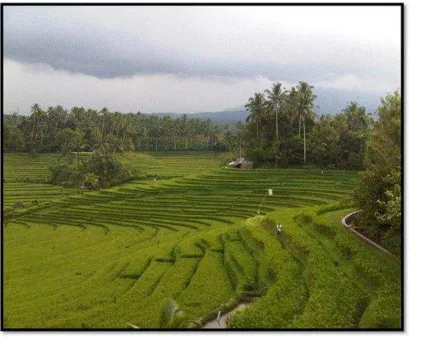
porch aims to reduce the length of slopes or out on the road slope excavation or soil store up transverse slope parallel to contour lines are equipped with channel infiltration, drainage and crop terraces amplifier, thus minimizing the occurrence of runoff and soil loss is reduced. Making a terrace can be expected to give the water a chance to soak into the ground (infiltration). Further said that the addition of mulch can also reduce the rate of erosion, because the mulch will keep the soil from direct blows rainwater and surface runoff, so that erosion can be reduced. It should also be done to reduce the addition of plant density blows rainwater that falls to the ground, the kinetic energy is reduced, so the erosion can be reduced, and which need to be considered in addition to the terrace is the time of planting. Planting according Sasih or month in Balinese calendar, in addition to addressing climate change also prevent pests and diseases. According to Balinese Hinduism, Sasih (planting time based Balinese calender), Subak (irrigation organization), and swales (Terrace) is soil and water conservation based on local wisdom Bali have great influence on the growth and the results obtained. One of the local wisdom in Bali, is Paddy field with terrace ring and Subak system (Figure 2).
Figure 2. Paddy field with Terracering and Subak System
Conclusion and Suggestion
Conclusion
Based on the research results of erosion that occurs in a variety of land use in the Ayung Watershed can be summed up as follows:
1) Prediction of erosion in the Ayung Watershed from very light to very heavy ranged from 0.98 to 1717.12 tons/ha/year. Very light erosion occurred in the use of Paddy field and forests, while very heavy erosion occurred on the mixed-crop land use, cultivated land, scrubs, while erosion is tolerable ranges from 22.60 to 57.00 tons/ha/year.
2) Soil and water onservation efforts based on local wisdom namely: (a) increasing the density of plants in the land use of citrus mix with coffee plants, with individual terracing and set the time of fertilization to overcome the climate change; (b) cropping pattern crops corn or legume with horticultural crops at cultivated land use, the addition of crop residues used as mulch or organic material, the contruction of level terrace or cotour terrace according to the topography, with the amplifier crops commonly grown in the terrace area of research, and set the time of planting to overcome with climate change; (c) set the time of planting rice in Paddy field based Sasih to overcome climate change, so that the distribution of water by a water control system running smoothly; (d) planting trees in border river or cliff, then at that location sacred by praying and giving Balinese cloth (cloth poleng or checkered black and white) to put on the tree; (e) regulation form prohibition of permitting or tightening the construction of tourism facilities along the border Ayung river.
Extension routinely on soil and water conservation models based on local wisdom that is appropriate to local conditions and prohibits the use of public land with slopes above 25% as agricultural crops.
Gives understanding to the public of the importance of watershed and increase community participation in watershed management.
References
Arsyad, S. (2010). Soil and Water Conservation. Publisher IPB Press, Bogor.
Asdak, C. (2004). Hydrology and Watershed Management.Gadjah Mada University Press.Yogyakarta. Bakosurtanal. (2000). Eart Image Map. Jakarta.
BPDAS Unda Anyar. (2009). Recent reports Unda characteristics. Directorate General of Land Rehabilitation and Social Forestry. Department of Forestry.
Bols, P.L. (1978). The Iso – Erodent Map of Java and Madura. Sri Bogor. Indonesia.
Dai and Rosman. 1970. Map Soil Types. Indonesia.
Ministry of Forestry RI. (1997). Criteria for Determining Priority Order Watershed. Directorate General of Land Rehabilitation and Social Forestry. Jakarta
Ministry of Forestry RI. (2009). Regulation on Guidelines No.P.32/Menhut-II/2009 Plan of Integrated Watershed Management. Jakarta.
Ministry of Agriculture. (2010). Technical Guidelines for PIP in 2010. Directorate of Irrigation Water Management, Directorate General for Agriculture Infrastructur. http //: kibegus-homedesign. Blogspot technical com/2011/04/term-in development. Accessed 12 September 2012.
Hammer,W.I. (1980). A. Soil Degradation Assesment Metodelogy Soil Conservation Consultan Report. INS/78/006.Technical Note No. 7 CRS. Bogor.
Hammer,W.I. (1981). Second Soil Conservation.Consultant Report. AGOF.INS/78/006. Technical Note. No.7CSR. Bogor.
Hardjoamidjojo, S. and S. Sukartaatmadja. (2008). Preserving Soil and Water Engineering. Graha Science and Creata-LPPM. Bogor.
Indah Permata, O. (2012). Terassering Understanding. http://Evaluation of Local Wisdom improve food security land. Accessed 29 March 2014.
Poerbandono, A., Basya., A.B. Harto, and P. Rallyant. (2006). Evaluation of Erosion Behavior Change Upper Citarum Watershed Modeling with Spatial. Journal of Infrastructure and Environment.Vol II, 2. Page 21-30.
Ridwan, N.A. (2007). Scientific Grounding Local Wisdom.Journal IBDA. Vol: 5 No.1. Page27-38, Purwokerto.
Salain, P.R. (2007). Role of Local Wisdom in Spatial Planning in Bali. In Raka Dalem, A.A.G., N. Wardi, W. Suarna, I.W.S. Adnyana. Editors. Local Wisdom in Environmental Management.Udayana University. Denpasar. Page 71-94. Suhartini. (2009). Local Wisdom Society Studies in Natural
Resources Management and Environment. Proceeeding National Seminar on Application of Mathematics and Science Education, Faculty of Mathematics and Natural Sciences, State University of Yogyakarta. Yogyakarta. Sri Sumarniasih, Made. 2013. Photos of Personal Documents.
Denpasar. Bali.
Suwardjo,H., N.L.Nurida and Irawan. (1995). Steps in the Development of Conservation Farming Critical Hills Region of Yogyakarta. Proceeding of Seminar on Applied Systems Research Watershed Hills Critical Zone. Yogyakarta. Sutrisno, A. (2011). Existence of Subak In Ex Transmigration Areas in North Bengkulu. Bengkulu. Accessed 12 September 2012
Utomo, W. H. (1994). Soil Erosion and Conservation. Brawijaya University. Malang.
Wischmeier,W.M., and D. D. Smith . (1978). Predicting Rainfall Erosion Losses-A Guide toConservation Planning.
Washington DC,US Gov.US Dep of Agriculture, Agric.Print Off. Handbook.