THE POTENTIAL OF GIS AS A MANAGEMENT TOOL FOR AVENUE TREES
POPULATION IN SMALL COMMUNITIES; A CASE STUDY OF IDI-SHIN
COMMUNITY, IBADAN, NIGERIA
O.S. Olokeoguna *, O.O. Akintolaa, E.K. Abodunrina
a Dept. of Forestry Technology, Federal College of Forestry, Nigeria – (Olokeogun, Akintola, Abodunrin) [email protected], [email protected], [email protected]
Youth Forum
KEY WORDS: GIS, Avenue Trees, Urban Forest
ABSTRACT:
This study demonstrates the potentials of Geographic Information System (GIS) as a management tool for avenue trees (Street trees) populations in small communities (using Idi-Ishin community, Ibadan, Nigeria as a case study). GIS is a decision support system which integrate data or set of data from different sources, bringing them under the same referencing system in a computer system. An Ikonos Imagery (1m Spatial Resolution) of the study area was digitized to produce a digital map using ArcGIS 10.1 version. The avenue trees species ≥ 5cm diameter at breast height (DBH) was selected for enumeration. These trees were then measured and tagged. The Height, Girth and Geographic location (X &Y coordinate) of the trees were measured with Haga altimeter, Girthing tape and Hand held Global Positioning System (GPS) respectively. The species and families of the trees enumerated were also identified. Data were analysed for basal area (BA) and volume (V). A total number of 43 avenue trees were assessed in Idi-Ishin Community. Roystonea regia accounted for the majority of the avenue trees (25.58%), followed by Polyanthia longiflora (23.26%), Gliricida seprium (20.93%), Eucalyptus toreliana (13.95%), Delunix regea (6.98%). However Terminalia catapa, Terminalia radii, Azadrachita indica and Newbodia levis had the same abundance of 2.33%. It was also observed that the benefits derived from these avenue trees includes; Carbon sequestration, Beautification, Wind break and shade. A spatial relational database was created for the assessed avenue trees using ArcCatalog of ArcGIS 10.1 version. Based on the findings from the study (which serves as baseline information for the management of the avenue trees in the study area), it was therefore recommended that subsequent assessment should be carried out at 3-5 year interval in other to ensure proper and continuous monitoring and updating of the data.
1. INTRODUCTION
Avenue (Street) tree is an important component of the urban forest. They are trees located on land forming or adjacent to a street, which have both direct and indirect effect on those using that street (Heimlich et al, 2008). With their canopies overhanging the roadway, street trees help to protect asphalt from deterioration by sunlight (Mcpherson et al, 1993) and reduce storm-water runoff from impervious surfaces (Nowak and Crane, 2002). Their shade keeps pedestrians, parked cars, and nearby buildings cool in the summer (Scott et al, 1999; Akbari, 2002). Avenue trees can also help to buffer the sights and sounds of nearby roadways (Fang and Ling, 2003) and reduce driving stress (Wolf, 2003). The appearance of commercial areas is also improved by the presence of avenue tree (Anderson and Cordell, 1988). Fuwape (2001), stated that, the benefits of street trees include: amelioration of weather pattern, provision of clean air, protection of biological diversity, protection of watershed, soil and food crops and provision of recreational facilities. Street trees can contribute significantly to human health. For instance, study has shown that children living in areas with more street trees had lower prevalence of asthma compared to those living where there are few street trees (Lovasi et al., 2008). Because of their proximity to pedestrians, cars, sidewalks and other infrastructure, street trees can be both major assets and major liabilities.
Despite the various benefits offered by street trees, little or no effort has been made to take full advantage of them. Therefore a need to encourage such arose and GIS is presumed to be a better and long lasting management tool. GIS is a decision support
system which integrate data or set of data from different sources, bringing them under the same referencing system in a computer system. The Spatial analytical functions of GIS prove to aid better understanding of the street trees. GIS can aid planners, local elected officials, landscape architects, urban foresters, and non profit groups in quantifying benefits and costs of municipal trees (McPherson et al., 2002). GIS tend to offer Long-term management, reduction of tree program costs, and increasing street trees’ ability to maintain benefits. The results of the various spatial analyses of GIS can be presented graphically and can also be used for broad regional studies or to create detailed small site assessments. The GIS model also contains algorithms for tree growth to allow users to create maps of future tree cover and estimate the benefits provided by those larger trees. This paper therefore examined the potentials of Geographic Information System (GIS) as a management tool for street tree (Avenue trees) populations in small communities, using Idi-shin Community as a case study.
2. METHODOLOGY
2.1 THE STUDY AREA
Idi-Isin Community is situated in Jericho, Ibadan North West Local Government Area of Oyo State, Nigeria. The area lies between longitude 3° 51' 33.19" E to 3° 51' 3.56"E and latitude7° 23' 56.04" N to 7° 24' 20.55" N. It has annual rainfall of about 1400mm-1500mm and average relative humidity of about 65%. The average temperature is 320C with two distinct seasons, which are dry, usually commences from November to The International Archives of the Photogrammetry, Remote Sensing and Spatial Information Sciences, Volume XLI-B6, 2016
March and rainy season. It is bounded by Jericho and Ile-titun community.
Figure 1. Location of the Study Area
2.2 Data Source
Both secondary and primary data source was used for this project. The secondary data collection includes;
i. An Ikonos Imagery (1m spatial resolution) of the study area, sourced from Google Earth
While the primary data include;
i. The tree species assessment data
ii. The coordinates of geographic features and location of the urban forest trees within the study area using Global Positioning System (GPS)
2.3 Data Conversion
The satellite image covering the study area was taken to the site for ground truthing. The imagery was then geo-referenced. Features (such as buildings and roads) were extracted (digitized) using ArcGIS 10.1 software. The roads were categorized into avenue, close, crescent, streets. The step by step approach (methodology) taken to achieve the stated objectives of this study are the following;
Figure 2. Flow Chart of the Research Methodology
2.4 Database Creation
A spatial database was created for the assessed avenue trees using ArcGIS 10.1 version. The attribute database was created by typing the attribute data into the themes attribute tables. .
3. SPATIAL ANALYSIS AND INFORMATION
PRESENTATION 3.1 Map Production
Figure 3. Produced Map of Idi-Ishin Community Procure Satellite
Image Enhancement
Ground Truthing
Image Geo-referencing
2D Feature Extraction
Identification, Measurement and
Tagging of Avenue Trees
Data Analysis
Database Creation Map
Table
s Maps Charts
Field Check
-X & Y Coordinates -Height &Girth -Species & Family -Physical Condition -Benefits
-Pictures
Figure 4. Spatial Distribution of Avenue Trees
Table 1 presents the abundance and geo-spatial location of the tree species encountered. A total number of 43 avenue trees were assessed in Idi-Ishin Community. In terms of the species abundance, Roystonea regia accounted for the majority of the avenue trees (25.58%), followed by Polyanthia longiflora (23.26%), Gliricida seprium (20.93%), Eucalyptus toreliana (13.95%), Delunix regea (6.98%). However Terminalia catapa, Terminalia radii, Azadrachita indica and Newbodia levis had the same abundance of 2.33%.
It was also observed from the study that the avenue trees are not well spatially distributed. The total Diameter at Breast Height (DBH) and Height of the assessed avenue trees species are 2847 cm and 366.8m respectively.
3.3 Physical Conditions and Benefits of the Avenue Trees
S/N NAME PHYSICAL
CONDITION BENEFITS
1 Roystonea
regia No physical defect Beautification, Shade
2 Roystonea
regia No physical defect Beautification, Shade
3 Roystonea
regia No physical defect Beautification, Shade
4 Roystonea
regia No physical defect Beautification, Shade
5 Roystonea
regia No physical defect Beautification, Shade
6 Roystonea
regia No physical defect Beautification, Shade
7 Roystonea
regia No physical defect Beautification, Shade
8 Roystonea
regia No physical defect Beautification, Shade
9 Roystonea
regia No physical defect Beautification, Shade
10 Roystonea
regia No physical defect Beautification, Shade
11 Roystonea
regia No physical defect Beautification, Shade
12 Newbodia
levis No physical defect Carbon sequestration, Shade
13 Gliricida
seprium No physical defect Carbon sequestration, Shade
longiflora No physical defect Carbon sequestration, Beautification, Wind break
21 Polyanthia
longiflora No physical defect Carbon sequestration, Beautification, Wind break
22 Polyanthia
longiflora No physical defect Carbon sequestration, Beautification, Wind break
23 Polyanthia
longiflora No physical defect Carbon sequestration, Beautification, Wind break
24 Polyanthia
longiflora No physical defect Carbon sequestration, Beautification, Wind break
25 Polyanthia
longiflora No physical defect Carbon sequestration, Beautification, Wind break
26 Polyanthia
longiflora No physical defect Carbon sequestration, Beautification, Wind break
27 Polyanthia
longiflora No physical defect Carbon sequestration, Beautification, Wind break
28 Polyanthia
longiflora No physical defect Carbon sequestration, Beautification, Wind break
29 Polyanthia
longiflora No physical defect Carbon sequestration, Beautification, Wind break
30 Azadrachita
indica No physical defect Carbon sequestration, Beautification, Wind break
31 Delunix regea No physical defect Carbon
sequestration, Shade
32 Eucalyptus
spp No physical defect Carbon sequestration
33 Eucalyptus
spp No physical defect Carbon sequestration
34 Eucalyptus
spp No physical defect Carbon sequestration
35 Gliricida
seprium No defect, physical requires pruning
Carbon sequestration
36 Gliricida
seprium No defect, physical requires pruning
Carbon sequestration
37 Eucalyptus
toreliana No physical defect Carbon sequestration, Shade
38 Eucalyptus
toreliana No physical defect Carbon sequestration, Shade
39 Eucalyptus
toreliana No physical defect Carbon sequestration, Shade
40 Terminalia
catapa No physical defect Carbon sequestration, Shade
41 Gliricida
seprium No physical defect Carbon sequestration, The International Archives of the Photogrammetry, Remote Sensing and Spatial Information Sciences, Volume XLI-B6, 2016
Shade
42 Delunix regea No physical defect Carbon
sequestration
43 Terminalia
radii No physical defect Carbon sequestration, Beautification
Table 2. Idi-Ishin Avenue Trees Physical Conditions and Benefits
Table 2 presents the physical conditions of individual trees species and benefits from them. Physical observations from the avenue trees revealed that majority of trees had no physical defect, while some of the trees needed to be pruned. According to Britt (2008), poor pruning causes decay that may lead to severe damages to healthy trees.
It was also observed that the benefits derived from these avenue trees includes; Carbon sequestration, Beautification, Wind break and shade, which is in accordance with Fuwape (2001), who stated that, the benefits of street trees include: amelioration of weather pattern, provision of clean air, protection of biological diversity, protection of watershed, soil and food crops and provision of recreational facilities
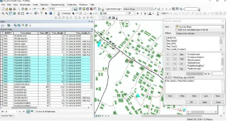
3.4 Database Query
Decision making requires information generated from spatial search and necessary operations performed. The database and graphics were manipulated and processed to generate information about the entities (spatial features) for GIS analysis. Data were retrieved from the database i.e. graphics and tabular data using ArcGIS 10.1. GIS analysis helps to ascertain the fitness of the database.
.
Figure 4. Query for Avenue trees (Polyanthia longiflora) available in the study area
Figure 5. Query for Individual Avenue Tree
4. CONCLUSION AND RECOMMENDATION
4.1 Conclusion
Sustainable management of avenue trees is highly essential because of their environmental benefits such as energy conservation, carbon storage, air pollution abatement, storm water runoff reduction, etc. They are also known to enhance real estate value, tourism and commerce and citizen quality of life. With all these benefits that avenue trees offers; its calls for proper management. GIS as a decision support system has proven to be an effective and efficient tool for the management of these avenue trees populations in small communities.
4.2 Recommendation
The findings from this study serve as baseline information for the management of the avenue trees population in the study area. Subsequent assessment of the avenue trees at 3-5 year interval is recommended in other to ensure proper and continuous monitoring and updating of the data. The use of GIS as a tool to manage avenue trees is also recommended to Local Government Authorities, State Government, Forestry Research Institute of Nigeria (FRIN), Forest Managers, etc, as GIS spatial analysis ensures efficient and economical ways for handling spatial problems. GIS will also ensure proper and continuous monitoring and updating of information about urban forest.
REFERENCES
Akbari, H., 2002. Shade trees reduce building energy use and CO2 emissions from power plants. Environmental
Pollution 116:S119-S126.
Anderson, L.M., and Cordell, K.K., 1988. Influence of trees on residential property values in Athens, Georgia (U.S.A): A survey based on actual sale prices. Landscape and Urban Planning 15:153-164.
Britt, C., 2008. Trees in Town II ; A new Survey of Urban Trees in England and Their Condition and Management Department for Communities and Local Government, 646 pp.
Fang, C., And Ling, D., 2003. Investigation of the noise reduction provided by tree belts Landscape and Urban Planning 63(4):187-195 Four Species in Toledo, Ohio, U.S. Before Removal of Ash Trees (Fraxinus spp) from Emerald Ash Borer (Agrilus planipennis) Arboriculture & Urban Forestry 34(1):47-53
Nowak, D.J., Crane, D.E., and Stevens, J.C., 2006. Air pollution removal by urban trees and shrubs in the United States. Urban Forestry & Urban Greening 4:115-123
McPherson, E.G., and Rowntree, R.A., 1993. Energy Conservation Potentials of Urban Tree Planting. Journal of Aboriculture 19(6):321-331
Lovasi, G.S., Quinn, J.W., Neckerman, K.M., Perzanowski, M.S., and Rundle, A., 2008. Children Living in Areas with More Street Trees Have Lover Prevalence of The International Archives of the Photogrammetry, Remote Sensing and Spatial Information Sciences, Volume XLI-B6, 2016
Asthma. Journal of Epidemiology and Community Health, 62, 647-649
Scott, K.I., Simpson, J.R., and McPherson, E.G., 1999. Effects of tree cover on parking lot microclimate and vehicle emissions. Journal of Aboriculture 25(3): 129-142 Wolf, K.L., 2003. Freeway roadside management: The urban
forest beyond the while line. Journal of Arboriculture 29(3):127-136