Open Geospatial Consortium
Approval Date:2012-01-30 Publication Date: 2012-02-17 External identifier of this OGC® document: http://www.opengis.net/doc/wfs-gaz-ap
Reference number of this OGC® document:
OGC 11-122r1
Version 1.0
Category
: OGC
®Best Practice
Editors:
Jeff Harrison, Panagiotis (Peter) A. Vretanos
Gazetteer Service -
Application Profile of the Web Feature Service Best Practice
Copyright ©
2012 Open Geospatial Consortium
To obtain additional rights of use, visit
http://www.opengeospatial.org/legal/
Warning
This document defines an OGC Best Practices on a particular technology or approach
related to an OGC standard. This document is not an OGC Standard and may not be
referred to as an OGC Standard. This document is subject to change without notice.
However, this document is an official position of the OGC membership on this particular
technology topic
.
Document type: OGC® Best Practice Paper
Document subtype:Application Profile
Contents
Page
1
Scope ... 13
2
Conformance ... 14
3
Normative references ... 14
4
Terms and definitions ... 15
5
Conventions ... 15
5.1
Abbreviated terms ... 15
5.2
UML notation ... 16
5.3
Document terms and definitions ... 16
6
Gazetteer Service overview ... 16
6.1
Processing Requests ... 16
7
Shared aspects ... 17
7.1
Introduction ... 17
7.2
Operation request encoding ... 17
8
GetCapabilities operation (required) ... 18
8.1
Introduction ... 18
8.2
Operation request ... 18
8.3
GetCapabilities operation response ... 19
Normal response ... 19
9
DescribeFeatureType operation (required) ... 19
9.1
Introduction ... 19
9.2
Examples ... 19
10
GetFeature operation (required) ... 22
10.1
Introduction ... 22
10.2
Examples ... 23
Example 1 - Get all entries in a gazetteer (empty filter) ... 23
Example 2 - Get an entry by name. ... 23
Example 3 - Get an entry by id. ... 23
Example 4 - Get entries within a BBOX ... 24
11
Transaction operation (optional) ... 29
11.1
Insert, Update and Delete Examples ... 29
Example: Insert ... 29
Example: Update ... 31
Example: Delete ... 32
11.2
Response ... 33
11.3
Exceptions ... 33
A.1.1
General capabilities ... 34
A.1.2
Required capabilities ... 34
A.2
Test module for Accessible Content conformance ... 34
A.2.1
Gazetteer Service advertised ... 34
A.2.2
SI_Gazetteer Feature Type response conformance ... 35
A.2.2
Gazetteers refer to available feature types ... 35
A.2.2
SI_LocationInstance conformance ... 35
A.2.2
SI_LocationInstance extensions conformance ... 36
Annex B: XML schemas ... 37
Annex C: Dictionaries ... 52
Annex D: Use Cases ... 150
D.1 Parent-Child Navigation Use Case ... 150
D.2 Geographic Selection Use Case ... 150
D.3 Integrated Query Use Case ... 150
D.4 GeoSynchronization via Mobile Apps Use Case ... 151
D.5 “Geocoding” Use Case ... 151
D.6 Service Invocation Use Case ... 152
Annex E: Transliteration domains ... 153
Annex F: Language and Script domains ... 161
Annex G: Dialect domains ... 175
Figures
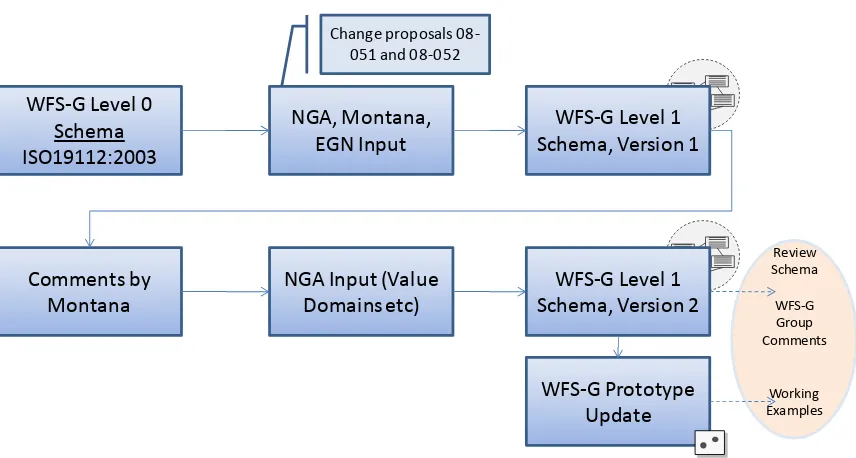
Figure 1 - WFS-G Profile update process ... 8
License Agreement
Permission is hereby granted by the Open Geospatial Consortium, Inc. ("Licensor"), free of charge and subject to the terms set forth below, to any person obtaining a copy of this Intellectual Property and any associated documentation, to deal in the Intellectual Property without restriction (except as set forth below), including without limitation the rights to implement, use, copy, modify, merge, publish, distribute, and/or sublicense copies of the Intellectual Property, and to permit persons to whom the Intellectual Property is furnished to do so, provided that all copyright notices on the intellectual property are retained intact and that each person to whom the
Intellectual Property is furnished agrees to the terms of this Agreement.
If you modify the Intellectual Property, all copies of the modified Intellectual Property must include, in addition to the above copyright notice, a notice that the Intellectual Property includes modifications that have not been approved or adopted by LICENSOR.
THIS LICENSE IS A COPYRIGHT LICENSE ONLY, AND DOES NOT CONVEY ANY RIGHTS UNDER ANY PATENTS THAT MAY BE IN FORCE ANYWHERE IN THE WORLD.
THE INTELLECTUAL PROPERTY IS PROVIDED "AS IS", WITHOUT WARRANTY OF ANY KIND, EXPRESS OR IMPLIED, INCLUDING BUT NOT LIMITED TO THE WARRANTIES OF MERCHANTABILITY, FITNESS FOR A PARTICULAR PURPOSE, AND NONINFRINGEMENT OF THIRD PARTY RIGHTS. THE COPYRIGHT HOLDER OR HOLDERS INCLUDED IN THIS NOTICE DO NOT WARRANT THAT THE FUNCTIONS CONTAINED IN THE INTELLECTUAL PROPERTY WILL MEET YOUR REQUIREMENTS OR THAT THE OPERATION OF THE INTELLECTUAL PROPERTY WILL BE UNINTERRUPTED OR ERROR FREE. ANY USE OF THE INTELLECTUAL PROPERTY SHALL BE MADE ENTIRELY AT THE USER’S OWN RISK. IN NO EVENT SHALL THE COPYRIGHT HOLDER OR ANY CONTRIBUTOR OF INTELLECTUAL PROPERTY RIGHTS TO THE INTELLECTUAL PROPERTY BE LIABLE FOR ANY CLAIM, OR ANY DIRECT, SPECIAL, INDIRECT OR CONSEQUENTIAL DAMAGES, OR ANY DAMAGES WHATSOEVER RESULTING FROM ANY ALLEGED INFRINGEMENT OR ANY LOSS OF USE, DATA OR PROFITS, WHETHER IN AN ACTION OF CONTRACT, NEGLIGENCE OR UNDER ANY OTHER LEGAL THEORY, ARISING OUT OF OR IN CONNECTION WITH THE IMPLEMENTATION, USE, COMMERCIALIZATION OR PERFORMANCE OF THIS INTELLECTUAL PROPERTY.
This license is effective until terminated. You may terminate it at any time by destroying the Intellectual Property together with all copies in any form. The license will also terminate if you fail to comply with any term or condition of this Agreement. Except as provided in the following sentence, no such termination of this license shall require the termination of any third party end-user sublicense to the Intellectual Property which is in force as of the date of notice of such termination. In addition, should the Intellectual Property, or the operation of the Intellectual Property, infringe, or in LICENSOR’s sole opinion be likely to infringe, any patent, copyright, trademark or other right of a third party, you agree that LICENSOR, in its sole discretion, may terminate this license without any compensation or liability to you, your licensees or any other party. You agree upon termination of any kind to destroy or cause to be destroyed the Intellectual Property together with all copies in any form, whether held by you or by any third party.
Except as contained in this notice, the name of LICENSOR or of any other holder of a copyright in all or part of the Intellectual Property shall not be used in advertising or otherwise to promote the sale, use or other dealings in this Intellectual Property without prior written authorization of LICENSOR or such copyright holder. LICENSOR is and shall at all times be the sole entity that may authorize you or any third party to use certification marks, trademarks or other special designations to indicate compliance with any LICENSOR standards or specifications.
This Agreement is governed by the laws of the Commonwealth of Massachusetts. The application to this Agreement of the United Nations Convention on Contracts for the International Sale of Goods is hereby expressly excluded. In the event any provision of this Agreement shall be deemed unenforceable, void or invalid, such provision shall be modified so as to make it valid and enforceable, and as so modified the entire Agreement shall remain in full force and effect. No decision, action or inaction by LICENSOR shall be construed to be a waiver of any rights or remedies available to it.
i.
Preface
This document represents the work of the OGC “WFS-G Standards Working Group”.
Access to consistent, reliable and local geographic names information is essential for understanding
communities and geo-social dynamics. In many situations, geographic names provide one of the most important
keys for referencing and accessing a variety of other information. And GeoNames databases, called Gazetteers,
are an information resource for representing places, groups of people and cultures.
There is growing interest in the development of a common feature-based model for access to named features,
often referred to as a gazetteer. Two major activities form the basis of this standard, an OGC Best Practice for
Gazetteer Services – Application Profile of the Web Feature Service Implementation Standard, an OGC
Discussion paper on gazetteers, and an ISO draft standard for geographic identifiers.
Since this resource is so important, there is growing global interest in sharing and updating geographic names
across a standard web-based service interface that is not controlled by any one organization or group. OGC has
met this need for open accessibility to geographic feature data via its creation of the Web Feature Service
(WFS) standard. The WFS standard defines an interface for specifying requests for retrieving and updating
geographic features across the Web using platform-independent calls. And of interest to the GeoNames
community, members of the OGC have been actively developing a special profile of the WFS which is being
designed specifically to support GeoNames.
The origin of the WFS-G profile can be traced to two activities that preceded its creation. In the OGC
Geospatial Fusion Services (GFS) interoperability initiative, an OGC gazetteer interface was initially defined
and implemented and eventually published as an OGC Discussion Paper. A separate effort in the ISO TC 211
working group led to a mature draft standard called “Spatial referencing by geographic identifiers” (ISO 19112)
that defines an abstract model to be implemented by a gazetteer service. The discussion paper and ISO 19112
eventually inspired OGC to formalize a WFS-G profile into an OGC Best Practices Document (05-035r2).
The WFS-G web service allows a client to search and retrieve elements of a geo-referenced vocabulary of
well-known place-names. The National Geospatial Intelligence Agency (NGA), the United States Geological Survey
(USGS), the State of Montana and other members of the OGC (under an effort called the WFS-G Working
Group) are actively making further improvements to the best practice WFS-G with the intent of moving it to a
full OGC standard. As a result of the WFS-G Working Group effort an operational WFS-G implementing this
profile has been deployed at the USGS in May 2011.
Enables platform-neutral access to well known place name vocabularies via an open web standard.
Enables collaborative maintenance of geographic names using the WFS. transaction interface and an
optional GeoSynchronization gatekeeper web service
Implements the ISO 19112 information model as a GMLSF Level 1 application schema.
Facilitates the development of a variety of location-based applications (Geo-Apps).
The Gazetteer Service is a specialized Application Profile (hereafter referred to as “profile”) of a Web Feature
Service that specifies a minimum set of Location Instances and operations required to support an instance of a
gazetteer service. Instances within a collection of gazetteer features may be related to each other and constitute
a hierarchical vocabulary of geographic places. The overall information model is here implemented as a GML
application schema that defines a general feature type to be served by a Gazetteer Service.
By using the capabilities of a Web Feature Server, the Gazetteer Service as proposed here exposes the following
interfaces to query location instances in a gazetteer database:
Get or Query GeoNames as features.
Retrieve properties of the gazetteer database, such as the location type class definitions and the spatial
reference system definitions.
Conduct transactional operations to enable updates by authoritative or ‘crowd-source’ communities.
This is implemented using WFS Transactional (WFS-T) capabilities.
In reference to the previous version of this profile (05-035r2), this version:
Implements more comprehensive set of elements from the ISO 19112 model to provide useful,
standardized services.
Provides methods to traverse parent/child relationships.
Improves standardization related to the definition of Location Instances and the correspondence to
SI_LocationType.
Integrates comments from OGC WFS-G Change Request 08-051 which indicated the previous version
of this profile (05-035r2) was not aligned properly with ISO 19112 and ISO 19139 v1.0. This version of
the profile is now conceptually aligned with ISO 19112, especially in regard to definition and cardinality
of attributes of SI_LocationInstance. Additionally, valid XML schemas were created that make use of
ISO 19139 v1.0, WFS 1.1.0 and GML 3.1.1.
Integrates comments from OGC WFS-G Change Request 08-052 which indicated the previous version
of this profile (05-035r2) can be improved with respect to its alignment with ISO 19112, GML/ISO
19136, ISO/TS 19139 and SDI architectures. These comments were adapted for use in GMLsf Level 1
Schemas. For example, INSPIRE proposed the need for an internationalised string and this was
Integrates approximately 90% of the material from a review of EuroGeoNames. The main items to note
in this category of include that in the original ISO 19112 of this profile there were several geometric
columns. For example, ISO 19112 uses the GeographicExtent property, Position. However, an objective
of the update was to use types in GMLsf Level 1 for this profile. To meet this objective,
GeographicExtent was changed to GeometryProperty so a geographic name feature can now be a Point,
Line, Polygon, Multipoint, Multisurface, etc.
Adds extensions based on NGA and USGS requirements including: Transliteration domain (Annex E),
Language and Script domains (Annex F), Dialect domain (Annex G), Designation domain (a value
description where the main value is ‘Historic’), Citation Code domain (a bibliographic reference that
indicates where the name came from), Type domain (Official or Variant), and Partner domain (identifies
the Partner, such as State of Montana, where the name of partner or null is used). The schema now also
references the following dictionaries: ISO 639-3:2007,
Codes for the representation of names of
languages,
ISO 3166-1,
Codes for the representation of names of countries and their subdivisions – Part
1: Country codes,
ISO 15924:2004,
Codes for the representation of names of scripts.
Updates the alternativeGeogeographicIdentifier so the domain values describe if the
alternativeGeographicIdentifier value is an official or variant name. Valid values are "official" or
"variant". This done so the schema can support multiple official and variant names. For example,
Canada has two official languages so there may be two official names, one in English and one in French.
Adds transactional interfaces based on WFS-T.
Review Schema
WFS‐G Group Comments
Working Examples
WFS‐G Level 0
Schema
ISO19112:2003
NGA, Montana,
EGN Input
Schema, Version 1
WFS‐G Level 1
Comments by
Montana
NGA Input (Value
Domains etc)
Schema, Version 2
WFS‐G Level 1
WFS‐G Prototype
Update
Change proposals 08‐ 051 and 08‐052
Figure 1 - WFS-G Profile update process
Suggested additions, changes, and comments on this draft report are welcome and encouraged. Such
suggestions may be submitted by OGC portal message, email message, or by making suggested changes in an
edited copy of this document.
The changes made in this document version, relative to the previous version, are tracked by Microsoft Word,
and can be viewed if desired. If you choose to submit suggested changes by editing this document, please first
accept all the current changes, and then make your suggested changes with change tracking on.
ii.
Submitting organizations
The following organizations submitted this document to the Open Geospatial Consortium.
a)
US Geological Survey (USGS)
b)
CubeWerx Inc.
c)
The Carbon Project
f)
Intergraph Government Solutions (Hexagon)
g)
State of Montana
iii.
Document contributor contact points
All questions regarding this document should be directed to the editor or the contributors:
Contact Company Email
Jeff Harrison The Carbon Project jharrisonATthecarbonprojectDO Tcom
Panagiotis (Peter) A. Vretanos
CubeWerx, Inc. pvretanosATcubewerxDOTcom
iv.
Revision history
Date Release Editor Primary clauses modified
Description
2011-08-18 0.9.4 Harrison Vretanos
all Complete revision
2005-04-12 New Document structure according to 05-009
2005-10-11 0.9.1 Fitzke all Complete revision.
2005- 0.9.1 Carl Reed Numerous Edits for consistency, grammar, etc. 2006-01-09 0.9.1 Jens Fitzke GetFeature
examples
Added more examples. Minor corrections on document and schema / example files. 2006-03-16 0.9.2 Rob
Atkinson
all ISO 19112 data model conformance 2006-05-29 0.9.3 Rob
Atkinson
All Editorial revision filling in missing clauses. Added abstract conformance tests. Some reorganisation of order
2006-05-29 0.9.3 Jens Fitzke All Minor edits in contributors section and others. Added further examples.
2006-06-03 0.93 Rob Atkinson
v.
Changes to the OGC Abstract Specification
The OpenGIS
®Abstract Specification does not require changes to accommodate this OpenGIS
®standard. It is
recommended however that the Abstract Specification be extended to explicitly incorporate the ISO 19112
standards to be consistent with current practice with regards to implementation of ISO TC211 standards.
vi.
Future work
This profile implements a complete set of elements from the ISO 19112 model with updates based on input
from OGC WFS-G Change Requests 08-051 and 08-052, EuroGeoNames, and extensions based on USGS and
NGA requirements to provide useful, standardized services, integrates representations of parent/child
relationships, standardizes definition of Location Instances and adds transactional interfaces based on WFS-T.
Future work should include upgrading the schemas for the latest version of GMLSF which uses GML 3.2 and
update the API to WFS 2.0.
Future extensions may include integration of OpenSearch, definition of additional output formats suitable for
GeoNames interaction via WFS-G such as HMTL, discussion of Point/Radius searches, discussion of
Foreword
This document is intended to replace OGC 05-035r2. It represents a complete revision of this former document
version, especially with respect to “Spatial referencing by geographic identifiers” (ISO 19112) that defines an
abstract model to be implemented by a gazetteer service. The Gazetteer Service is considered a profile of the
WFS standard. It is related to and makes use of the WFS, Filter Encoding, GMLSF, and ISO 19139 standards.
This document includes 7 annexes; Annexes A, B, C, E, F, G are normative, and Annex D is informative.
Attention is drawn to the possibility that some of the elements of this document may be the subject of patent
rights. The Open Geospatial Consortium Inc. shall not be held responsible for identifying any or all such patent
rights.
Introduction
This document defines a Gazetteer Service profile of the OGC Web Feature Service Standard. The OGC
Gazetteer Service allows a client to search and retrieve elements of a georeferenced vocabulary of well-known
place-names.
This profile extends the WFS interface in a way that a client is able to
–
Determine if a WFS implementation is acting as a Gazetteer Service.
–
Query the Gazetteer Service in order to retrieve place-name features without closer examination
of the feature type definitions
–
Access metadata about the gazetteer(s) provided by the service
–
Update place-name features using WFS transactions
–
Fetch place-name features that have Parent-Child relationships and then follow those links
To ensure semantic interoperability this profile defines the response schema elements according to the gazetteer
data model defined in ISO 19112 with updates based on input from OGC WFS-G Change Requests 08-051 and
08-052, EuroGeoNames, and extensions based on USGS and NGA requirements.
The overall design principle of this profile is to make gazetteer service behavior to be completely predictable,
and allowing setup to be as easy as possible – provided that a web feature service instance is available. The
following list gives an overview of the specific characteristics of a gazetteer service in comparison to a web
feature service:
–
The service type is “WFS” (this allows a server instance to act both as a general web feature
service and a gazetteer service).
–
The gazetteers (collection of locations) are described by metadata objects of a well defined
feature type (SI_Gazetteer). Presence of this feature type is sufficient to determine that a service acts a
gazetteer for the Location Instances described by the collection of SI_Gazetteer objects.
–
The Gazetteer WFS serves a feature type called SI_LocationInstance that contains the collections
of geographic names.
Gazetteer Profile of the Web Feature Service Candidate
Implementation Standard
1
Scope
This OGC document specifies the OGC Gazetteer Service operations as a profile of the
Web Feature Service (WFS-G). Services compliant with this standard shall provide
Location Instances derived from
SI_LocationInstance
. In Addition, they may
support queries based on the (parent/child) relationships of feature instances, as defined
in ISO 19112.
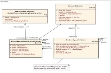
Geographic Features: SI_LocationInstance
The following UML class diagram illustrates the concept of the SI_Gazetteer and
SI_LocationInstance:
SI_LocationType Feature Types may be supported by a Gazetteer Service to describe the
Gazetteer’s internal organization.
Operations
To support query processing and updates, a gazetteer service has the following
operations:
GetCapabilities
As a web feature service, a gazetteer service must be able to describe its capabilities.
Specifically, it must indicate which SI_LocationInstance are supported by the service
and what operations are supported.
DescribeFeatureType
As a web feature service, a gazetteer service must be able, upon request, to describe
the structure of SI_LocationInstance it services.
GetFeature
As a web feature service, a gazetteer service must be able to service a request to
retrieve feature instances. In addition, the client should be able to specify which
feature properties to fetch and must be able to constrain the query spatially and
non-spatially.
Transaction
As a web feature service, a gazetteer service must be able to service transaction
requests.
A transaction request is composed of operations that modify features; that is
create, update, and delete operations on geographic features
.
2
Conformance
Conformance with this standard shall be checked using all the relevant tests specified in
Annex A (normative).
3
Normative references
amendments to, or revisions of, any of these publications do not apply. For undated
references, the latest edition of the normative document referred to applies.
ISO 19105:2000,
Geographic information — Conformance and Testing
ISO 19112:2003,
Geographic information — Spatial Referencing by Geographic
Identifiers
ISO 639-3:2007,
Codes for the representation of names of languages
ISO 3166-1,
Codes for the representation of names of countries and their subdivisions –
Part 1: Country codes
ISO 15924:2004,
Codes for the representation of names of scripts
OGC 05-008,
OGC Web Services Common Standard
OGC 04-094,
Web Feature Service Implementation Standard version 1.1
OGC 04-095,
Filter Encoding Implementation Standard version 1.1
OGC 06-049r1,
GML 3.1.1 simple features profile version 1.0
The OWS Common Standard contains a list of normative references that are also
applicable to this candidate Implementation Standard.
In addition to this document, this standard includes several normative XML Schema files.
These XML Schema files are bundled with the present document.
4
Terms and definitions
For the purposes of this standard, the definitions specified in Clause 4 of the OWS
Common Implementation Standard [OGC 05-008] shall apply. In addition, the following
terms and definitions apply.
Gazetteer: A database used to translate between different representations of geospatial
references, such as place names and geographic coordinates
5
Conventions
5.1
Abbreviated terms
Most of the abbreviated terms listed in Subclause 5.1 of the OWS Common
FTC: Feature Type Catalog
5.2
UML notation
Most diagrams that appear in this standard are presented using the Unified Modeling
Language (UML) static structure diagram, as described in Subclause 5.2 of [OGC
05-008].
5.3
Document terms and definitions
This document uses the standard terms defined in Subclause 5.3 of [OGC 05-008].
6
Gazetteer Service overview
A Gazetteer defines a set of
location instances,
each of which provides a binding between
representations of a location within a CRS and as an identifier
.
Each location instance is a
Feature
, and is a (possibly one of many) representation of a “real-world” object. The
representation of the real-world object within the Gazetteer is designed to be used to
perform this translation, and to allow the set of such Features to be discovered, searched,
accessed and updated.
The gazetteer service is thus WFS serving a predictably structured set of features
representing Gazetteers and the sets of location instances they contain.
6.1
Processing Requests
This section of the document outlines, in general terms, the protocol to be followed in
order to process Gazetteer Service requests. Processing requests for query would proceed
as follows:
1.
A client application would request a capabilities document from the WFS-G.
Such a document contains a description of all the operations that the WFS-G
supports, and a list of the feature types that the service offers. If the list of feature
types includes SI_Gazetteer and SI_LocationInstance, then the service is acting as
a Gazetteer.
2.
A client application (optionally) makes a request to a web feature service for the
definition of one or more of the feature types that the WFS-G can service. (This is
optional, and may be used to discover additional elements).
3.
Based on the definition of the SI_LocationInstance Feature Type the client
application generates a request as specified in the WFS interface [OGC 04-094]
4.
The WFS-G is invoked to read and service the request and generate a response
5.
In the event that an error has occurred, the WFS-G will generate an exception
report to indicate that fact.
Processing requests for transaction would proceed as follows:
1.
The client application requests a capabilities document from the web feature
service to verify that the service is acting as a gazetteer (i.e. the feature types
SI_Gazetteer and SI_LocationInstance exist) and that the server support the WFS
Transaction operation.
2.
A client application (optionally) makes a request to a web feature service for the
definition of the SI_LocationInstance feature type. (This is optional, and may be
used to discover additional elements).
3.
A client application submits a Transaction request to a web feature service. The
Transaction request may contain zero or more Insert, Update or Delete actions
that create, modify or delete one or more instances of SI_LocationInstance.
4.
When the WFS-G has completed processing the transaction request, it will
generate a status report and hand it back to the client. In the event that an error has
occurred, the status report will indicate that fact.
Note that “client application” may include Registries and other middleware, as well as
conventionally understood “end-users”.
Note also that a client may be “bound” to the Gazetteer service content by configuration,
or discover the implementing SI_LocationInstance through a services registry and may
thus be able to skip steps 1,2 and 3.
The definition of the WFS-G profile is intended to make the discovery and invocation of
WFS-G services possible through service registries.
7
Shared aspects
7.1
Introduction
This clause specifies aspects of the Gazetteer Service behavior that are shared by several
operations.
7.2
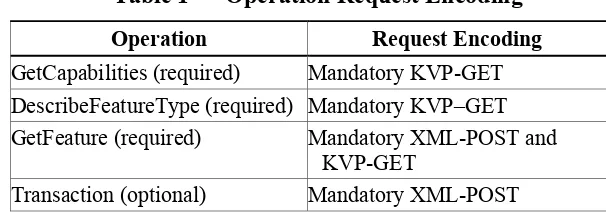
Operation request encoding
Table 1 — Operation Request Encoding
Operation
Request Encoding
GetCapabilities (required)
Mandatory KVP-GET
DescribeFeatureType (required) Mandatory KVP–GET
GetFeature (required)
Mandatory XML-POST and
KVP-GET
Transaction (optional)
Mandatory XML-POST
8
GetCapabilities operation (required)
8.1
Introduction
This is a standard WFS requirement, with both the request and response requirements
unchanged by the WFS-G profile.
The mandatory GetCapabilities operation allows clients to retrieve service metadata from
a Gazetteer server. The response to a GetCapabilities request shall be an XML document
containing service metadata about the server, including specific information about the
feature types it can service, and the supported operations on each feature type. This
clause specifies the XML document that a Gazetteer server must return to describe its
capabilities.
8.2
Operation request
The GetCapabilities operation request shall be as specified in Subclauses 7.2.2 through
7.2.4 of [OGC 05-008]. The “service”, “request”, and “AcceptVersions” parameters shall
be implemented by all gazetteer services. The “Sections” and “updateSequence”
parameters are optional implementation by gazetteer services. All gazetteer services shall
implement HTTP GET transfer of the GetCapabilities operation request, using KVP
encoding. Services can also implement HTTP POST transfer of the GetCapabilities
operation request, using XML encoding only.
8.3
GetCapabilities operation response
Normal response
The WFS-G profile creates no additional requirements of the WFS GetCapabilities
operation beyond the ability to serve the nominated SI_Gazetteer and
SI_LocationInstance.
9
DescribeFeatureType operation (required)
9.1
Introduction
The DescribeFeatureType operation allows gazetteer clients to retrieve schema
descriptions which define, how the gazetteer server will generate feature instances on
output (in response to GetFeature requests).
This profile makes no further changes to this WFS operation except that it defines a base
schema for certain feature types.
9.2
Examples
To request a feature type schema document, a client could issue the following
DescribeFeatureType operation request with minimum contents:
http://ogc.a-domain.org/wfs-g? service=WFS
&request=DescribeFeatureType
&typename=iso19112:SI_LocationInstance
&namespace=xmlns(iso19112=http://www.isotc211.org/iso19112)
The corresponding minimum request encoded in XML is:
<?xml version="1.0" ?> <wfs:DescribeFeatureType version="1.1.0"
service="WFS"
xmlns:iso19112="http://www.isotc211.org /iso19112" xmlns:xsi="http://www.w3.org/2001/XMLSchema-instance" xsi:schemaLocation="http://www.opengis.net/wfs
../wfs/1.1.0/WFS.xsd">
<TypeName>iso19112:SI_LocationInstance</TypeName> </wfs:DescribeFeatureType>
In response to such a request, the gazetteer server might generate a document that looks
like the following example:
<xs:schema targetNamespace="http://www.isotc211.org/19112" xmlns:iso19112="http://www.isotc211.org/19112"
xmlns:xs="http://www.w3.org/2001/XMLSchema" xmlns:gml="http://www.opengis.net/gml"
xmlns:gmdsf1="http://www.isotc211.org/2005/gmdsf1" elementFormDefault="qualified" version="1.0"> <xs:import namespace="http://www.opengis.net/gml"
schemaLocation="http://www.cubewerx.com/schemas/gml/3.1.1/base/gml.xsd" />
<xs:import namespace="http://www.w3.org/XML/1998/namespace" schemaLocation="http://www.w3.org/2001/xml.xsd" />
<xs:import namespace="http://www.isotc211.org/2005/gmdsf1"
schemaLocation="http://www.cubewerx.com/schemas/gazetteer/1.0.0/gmlsf1/f ull/gmd.xsd" />
<xs:complexType name="LanguageStringType"> <xs:simpleContent>
<xs:extension base="xs:string"> <xs:attribute ref="xml:lang" />
<xs:attribute name="transliterationDomain" type="xs:string" /> </xs:extension>
</xs:simpleContent> </xs:complexType> <!--
==================================================================== -->
- <!-- === PROP TYPE: AlternativeGeographicIdentifiersPropertyType ========
--> - <!--
==================================================================== -->
<xs:complexType name="AlternativeGeographicIdentifiersPropertyType"> <xs:sequence>
<xs:element ref="iso19112:alternativeGeographicIdentifier" maxOccurs="unbounded" />
</xs:sequence> </xs:complexType>
<xs:element name="alternativeGeographicIdentifier"> <xs:complexType>
<xs:sequence>
<xs:element name="partner" type="xs:string" minOccurs="0" /> <xs:element name="name" type="iso19112:LanguageStringType" /> <xs:element name="nameID" type="xs:string" minOccurs="0" /> <xs:element name="type" type="xs:string" minOccurs="0" />
<xs:element name="dateCommitted" type="xs:dateTime" minOccurs="0" /> <xs:element name="primary" type="xs:boolean" minOccurs="0" />
<xs:element name="citationCode" minOccurs="0"> <xs:complexType>
<xs:simpleContent>
<xs:restriction base="gml:CodeType">
<xs:attribute name="codeSpace" type="xs:anyURI" use="optional" /> </xs:restriction>
</xs:complexType> </xs:element> </xs:sequence> </xs:complexType> </xs:element> <!--
==================================================================== -->
- <!-- === FEATURE TYPE: SI_LocationInstance ==============================
--> - <!--
==================================================================== -->
<xs:element name="SI_LocationInstance"
type="iso19112:SI_LocationInstanceType" substitutionGroup="gml:_Feature" />
<xs:complexType name="SI_LocationInstanceType"> <xs:complexContent>
<xs:extension base="gml:AbstractFeatureType"> <xs:sequence>
<xs:element name="guid" type="xs:anyURI" minOccurs="0" /> <xs:element name="geographicIdentifier" type="xs:string" /> <xs:element name="alternativeGeographicIdentifiers"
type="iso19112:AlternativeGeographicIdentifiersPropertyType" minOccurs="0" />
<xs:element name="position" type="gml:PointPropertyType" />
<xs:element name="geographicExtent" type="gml:GeometryPropertyType" minOccurs="0" maxOccurs="unbounded" />
<xs:element name="dateOfCreation" type="xs:date" minOccurs="0" /> <xs:element name="dateModified" type="xs:date" minOccurs="0" /> <xs:element name="administrator"
type="gmdsf1:CI_ResponsiblePartyPropertyType" />
<xs:element name="spatialObject" type="xs:anyURI" minOccurs="0" /> <xs:element name="designation" minOccurs="0" maxOccurs="unbounded"> <xs:complexType>
<xs:simpleContent>
<xs:restriction base="gml:CodeType">
<xs:attribute name="codeSpace" type="xs:anyURI" use="optional" />
</xs:restriction> </xs:simpleContent> </xs:complexType> </xs:element>
<xs:element name="history" type="xs:string" minOccurs="0" /> <xs:element name="description" type="xs:string" minOccurs="0" /> <xs:element name="parent" type="gml:ReferenceType" minOccurs="0" maxOccurs="unbounded">
<xs:annotation>
<xs:appinfo
source="urn:x-gml:targetElement">iso19112:SI_LocationInstance/geographicIdentifier</xs :appinfo>
</xs:element>
<xs:element name="child" type="gml:ReferenceType" minOccurs="0" maxOccurs="unbounded">
<xs:annotation>
<xs:appinfo
source="urn:x-gml:targetElement">iso19112:SI_LocationInstance/geographicIdentifier</xs :appinfo>
</xs:annotation> </xs:element>
<xs:element name="locationType" type="gml:ReferenceType"> <xs:annotation>
<xs:appinfo
source="urn:x-gml:targetElement">iso19112:SI_LocationType/name</xs:appinfo> </xs:annotation>
</xs:element> </xs:sequence> </xs:extension> </xs:complexContent> </xs:complexType> </xs:schema>
10
GetFeature operation (required)
10.1
Introduction
The GetFeature operation allows retrieval of features from a gazetteer service. A
GetFeature request is processed by a WFS-G and when the value of the outputFormat
attribute is set to text/gml; subtype=gml/3.1.1, a GML instance document, containing the
result set, is returned to the client
This profile makes no changes to this WFS operation.
The GetFeature operation must support the following behaviour:
1.
get all entries in a gazetteer (empty filter)
2.
get entry by name
3.
get entry by id
10.2
Examples
Example 1 – Get all entries in a gazetteer (empty filter)
<?xml version="1.0" encoding="UTF-8"?><GetFeature xmlns="http://www.opengis.net/wfs" xmlns:iso19112="http://www.isotc211.org/19112" xmlns:ogc="http://www.opengis.net/ogc"
xmlns:xsi="http://www.w3.org/2001/XMLSchema-instance"
xmlns:gml="http://www.opengis.net/gml" service="WFS" version="1.1.0" outputFormat="text/xml; subtype=gml/3.1.1">
<Query typeName="iso19112:SI_LocationInstance" srsName="EPSG:4326"/> </GetFeature>
Example 2 - Get an entry by name.
<?xml version="1.0" encoding="UTF-8"?><GetFeature xmlns="http://www.opengis.net/wfs" xmlns:iso19112="http://www.usgs.gov/gnis" xmlns:ogc="http://www.opengis.net/ogc"
xmlns:xsi="http://www.w3.org/2001/XMLSchema-instance"
xmlns:gml="http://www.opengis.net/gml" service="WFS" version="1.1.0" outputFormat="text/xml; subtype=gml/3.1.1" maxFeatures="100"
handle="">
<Query typeName="iso19112:SI_LocationInstance" srsName="EPSG:4326"> <ogc:Filter>
<ogc:PropertyIsEqualTo>
<ogc:PropertyName>iso19112:SI_LocationInstance/alternativeGeographicId entifiers/alternativeGeographicIdentifier/name</ogc:PropertyName> <ogc:Literal>Hawaii</ogc:Literal>
</ogc:PropertyIsEqualTo> </ogc:Filter>
</Query> </GetFeature>
Example 3 - Get an entry by id.
<?xml version="1.0" encoding="UTF-8"?>
<GetFeature xmlns="http://www.opengis.net/wfs" xmlns:gnis="http://www.usgs.gov/gnis"
xmlns:ogc="http://www.opengis.net/ogc"
xmlns:xsi="http://www.w3.org/2001/XMLSchema-instance"
xmlns:gml="http://www.opengis.net/gml" service="WFS" version="1.1.0" outputFormat="text/xml; subtype=gml/3.1.1" maxFeatures="100"
handle="">
<Query typeName="gnis:SI_LocationInstance" srsName="EPSG:4326"> <Filter>
<FeatureId fid="434791DB6C5BBB0D002324020000"/> </Filter>
Example 4 – Get entries within a BBOX
A client would start to retrieve gazetteer metadata from SI_Gazetteer feature instances:
<?xml version="1.0" encoding="UTF-8"?>
<GetFeature xmlns="http://www.opengis.net/wfs" xmlns:iso19112="http://www.isotc211.org/19112" xmlns:ogc="http://www.opengis.net/ogc"
xmlns:xsi="http://www.w3.org/2001/XMLSchema-instance"
xmlns:gml="http://www.opengis.net/gml" service="WFS" version="1.1.0" outputFormat="text/xml; subtype=gml/3.1.1" maxFeatures="100"
handle="">
<Query typeName="iso19112:SI_LocationInstance" srsName="EPSG:4326"> <ogc:Filter>
<ogc:BBOX>
<ogc:PropertyName>position</ogc:PropertyName> <gml:Envelope srsName="EPSG:4326"
xmlns:gml="http://www.opengis.net/gml"> <gml:lowerCorner>-122.424727851308 37.8255919861654</gml:lowerCorner>
<gml:upperCorner>-122.420793831551 37.8277556970318</gml:upperCorner>
</gml:Envelope> </ogc:BBOX>
</ogc:Filter> </Query>
</GetFeature>
The server returns a feature collection with SI_Gazetteer feature instances:
<?xml version="1.0" encoding="UTF-8"?>
<wfs:FeatureCollection xmlns:wfs="http://www.opengis.net/wfs" xmlns:gml="http://www.opengis.net/gml"
xmlns="http://www.isotc211.org/19112"
xmlns:gmdsf1="http://www.isotc211.org/2005/gmdsf1"> <gml:featureMember>
<SI_LocationInstance
id="CWFID.SI_LOCINST.0.76207.4D91FA5285742EC8202324020000"> <guid>{865C52A6-53D9-45A6-832E-35425357253E}</guid> <geographicIdentifier>218080</geographicIdentifier> <alternativeGeographicIdentifiers>
<alternativeGeographicIdentifier> <name>Alcatraz Island</name>
<nameID>{769EBACE-F39A-478F-E044-00144F233E68}</nameID> <type>official</type>
<primary>true</primary>
</alternativeGeographicIdentifier> <alternativeGeographicIdentifier> <name>Pelican Island</name>
<nameID>{769EBACE-F3A0-478F-E044-00144F233E68}</nameID> <type>variant</type>
<primary>false</primary>
<alternativeGeographicIdentifier> <name>Alcatrazes Island</name>
<nameID>{769EBACE-F39B-478F-E044-00144F233E68}</nameID> <type>variant</type>
<primary>false</primary>
</alternativeGeographicIdentifier> <alternativeGeographicIdentifier> <name>Bird Island</name>
<nameID>{769EBACE-F39C-478F-E044-00144F233E68}</nameID> <type>variant</type>
<primary>false</primary>
</alternativeGeographicIdentifier> <alternativeGeographicIdentifier> <name>Yerba Buena</name>
<nameID>{769EBACE-F3A2-478F-E044-00144F233E68}</nameID> <type>variant</type>
<primary>false</primary>
</alternativeGeographicIdentifier> <alternativeGeographicIdentifier> <name>Isla De Los Alcatraces</name>
<nameID>{769EBACE-F39E-478F-E044-00144F233E68}</nameID> <type>variant</type>
<primary>false</primary>
</alternativeGeographicIdentifier> <alternativeGeographicIdentifier> <name>Isla De Alcatraces</name>
<nameID>{769EBACE-F39D-478F-E044-00144F233E68}</nameID> <type>variant</type>
<primary>false</primary>
</alternativeGeographicIdentifier> <alternativeGeographicIdentifier> <name>Los Alcatrasses</name>
<nameID>{769EBACE-F39F-478F-E044-00144F233E68}</nameID> <type>variant</type>
<primary>false</primary>
</alternativeGeographicIdentifier> <alternativeGeographicIdentifier> <name>The Rock</name>
<nameID>{769EBACE-F3A1-478F-E044-00144F233E68}</nameID> <type>variant</type>
<primary>false</primary>
</alternativeGeographicIdentifier> </alternativeGeographicIdentifiers> <position>
<gml:Point srsName="EPSG:4326">
<gml:pos srsName="EPSG:4326" srsDimension="3">-122.4233048 37.8265946 0</gml:pos>
</gml:Point> </position>
<dateOfCreation>1981-01-19</dateOfCreation> <dateModified>2010-03-02</dateModified> <administrator>
<gmdsf1:individualName>USGS</gmdsf1:individualName> <gmdsf1:voice>303-236-5900</gmdsf1:voice>
<gmdsf1:deliveryPoint>Box 25046 Denver Federal Center</gmdsf1:deliveryPoint>
<gmdsf1:city>Denver</gmdsf1:city>
<gmdsf1:administrativeArea>Colorado</gmdsf1:administrativeArea> <gmdsf1:postalCode>80225</gmdsf1:postalCode>
<gmdsf1:country>USA</gmdsf1:country> <gmdsf1:hoursOfService>8:00am to 4:00pm</gmdsf1:hoursOfService>
<gmdsf1:role>custodian</gmdsf1:role> </gmdsf1:CI_ResponsibleParty>
</administrator>
<history>Begun as a military fortification and the site of the first U.S. lighthouse on the Pacific Coast (1854), Alcatraz was the first official Army prison in the nation. In 1934, the facility was transferred to civilian authority and it became the repository for the most hardened criminals. Alcatraz represents the far end of the
penological spectrum, designed for punishment and incarceration only, rather than rehabilitation. The prison was closed in 1963, and ten years later the island was opened to the public as the first unit of the Golden Gate National Recreation Area.</history>
<description>National Historic Landmark open to the public</description>
<parent title="San Francisco" role="in_county"
href="http://wfsg.usgs.gov/cubewerx/cubeserv.cgi?config=full&datast ore=full&service=WFS&request=GetFeature&typeName=iso19112:S I_LocationInstance&FILTER=<ogc:Filter><ogc:PropertyIsEqual To><ogc:PropertyName>geographicIdentifier</ogc:PropertyName ><ogc:Literal>277302</ogc:Literal></ogc:PropertyIsEqu alTo></ogc:Filter>" />
<parent title="California" role="in_state"
href="http://wfsg.usgs.gov/cubewerx/cubeserv.cgi?config=full&datast ore=full&service=WFS&request=GetFeature&typeName=iso19112:S I_LocationInstance&FILTER=<ogc:Filter><ogc:PropertyIsEqual To><ogc:PropertyName>geographicIdentifier</ogc:PropertyName ><ogc:Literal>1779778</ogc:Literal></ogc:PropertyIsEq ualTo></ogc:Filter>" />
<locationType title="Island"
href="http://wfsg.usgs.gov/cubewerx/cubeserv.cgi?config=full&datast ore=full&service=WFS&request=GetFeature&typeName=iso19112:S I_LocationType&FILTER=<ogc:Filter><ogc:PropertyIsEqualTo&g t;<ogc:PropertyName>name</ogc:PropertyName><ogc:Literal& gt;Island</ogc:Literal></ogc:PropertyIsEqualTo></ogc:Fil ter>" />
</SI_LocationInstance> </gml:featureMember> <gml:featureMember> <SI_LocationInstance
<alternativeGeographicIdentifiers> <alternativeGeographicIdentifier> <name>Alcatraz</name>
<nameID>{769EBAE8-64A3-478F-E044-00144F233E68}</nameID> <type>official</type>
<primary>true</primary>
</alternativeGeographicIdentifier> </alternativeGeographicIdentifiers> <position>
<gml:Point srsName="EPSG:4326">
<gml:pos srsName="EPSG:4326" srsDimension="3">-122.4227493 37.8268723 0</gml:pos>
</gml:Point> </position>
<dateOfCreation>1995-01-01</dateOfCreation> <administrator>
<gmdsf1:CI_ResponsibleParty>
<gmdsf1:individualName>USGS</gmdsf1:individualName> <gmdsf1:voice>303-236-5900</gmdsf1:voice>
<gmdsf1:deliveryPoint>Box 25046 Denver Federal Center</gmdsf1:deliveryPoint>
<gmdsf1:city>Denver</gmdsf1:city>
<gmdsf1:administrativeArea>Colorado</gmdsf1:administrativeArea> <gmdsf1:postalCode>80225</gmdsf1:postalCode>
<gmdsf1:country>USA</gmdsf1:country> <gmdsf1:hoursOfService>8:00am to 4:00pm</gmdsf1:hoursOfService>
<gmdsf1:role>custodian</gmdsf1:role> </gmdsf1:CI_ResponsibleParty>
</administrator>
<designation>Administered Federal</designation>
<description>National Historical Landmark</description> <parent title="San Francisco" role="in_county"
href="http://wfsg.usgs.gov/cubewerx/cubeserv.cgi?config=full&datast ore=full&service=WFS&request=GetFeature&typeName=iso19112:S I_LocationInstance&FILTER=<ogc:Filter><ogc:PropertyIsEqual To><ogc:PropertyName>geographicIdentifier</ogc:PropertyName ><ogc:Literal>277302</ogc:Literal></ogc:PropertyIsEqu alTo></ogc:Filter>" />
<parent title="California" role="in_state"
<locationType title="Building"
href="http://wfsg.usgs.gov/cubewerx/cubeserv.cgi?config=full&datast ore=full&service=WFS&request=GetFeature&typeName=iso19112:S I_LocationType&FILTER=<ogc:Filter><ogc:PropertyIsEqualTo&g t;<ogc:PropertyName>name</ogc:PropertyName><ogc:Literal& gt;Building</ogc:Literal></ogc:PropertyIsEqualTo></ogc:F ilter>" />
</SI_LocationInstance> </gml:featureMember> <gml:featureMember> <SI_LocationInstance
id="CWFID.SI_LOCINST.0.76209.4D91FA52A0661B747E2324020000"> <guid>{32CE40C6-C3DC-11DE-9C20-00144F233E68}</guid> <geographicIdentifier>1809338</geographicIdentifier> <alternativeGeographicIdentifiers>
<alternativeGeographicIdentifier>
<name>Alcatraz Island Lighthouse</name>
<nameID>{769EBAEA-CA3E-478F-E044-00144F233E68}</nameID> <type>official</type>
<primary>true</primary>
</alternativeGeographicIdentifier> </alternativeGeographicIdentifiers> <position>
<gml:Point srsName="EPSG:4326">
<gml:pos srsName="EPSG:4326" srsDimension="3">-122.4219159 37.826039 0</gml:pos>
</gml:Point> </position>
<dateOfCreation>1999-03-15</dateOfCreation> <administrator>
<gmdsf1:CI_ResponsibleParty>
<gmdsf1:individualName>USGS</gmdsf1:individualName> <gmdsf1:voice>303-236-5900</gmdsf1:voice>
<gmdsf1:deliveryPoint>Box 25046 Denver Federal Center</gmdsf1:deliveryPoint>
<gmdsf1:city>Denver</gmdsf1:city>
<gmdsf1:administrativeArea>Colorado</gmdsf1:administrativeArea> <gmdsf1:postalCode>80225</gmdsf1:postalCode>
<gmdsf1:country>USA</gmdsf1:country> <gmdsf1:hoursOfService>8:00am to 4:00pm</gmdsf1:hoursOfService>
<gmdsf1:role>custodian</gmdsf1:role> </gmdsf1:CI_ResponsibleParty>
</administrator>
<history>Built in 1909.</history>
<parent title="San Francisco" role="in_county"
<parent title="California" role="in_state"
href="http://wfsg.usgs.gov/cubewerx/cubeserv.cgi?config=full&datast ore=full&service=WFS&request=GetFeature&typeName=iso19112:S I_LocationInstance&FILTER=<ogc:Filter><ogc:PropertyIsEqual To><ogc:PropertyName>geographicIdentifier</ogc:PropertyName ><ogc:Literal>1779778</ogc:Literal></ogc:PropertyIsEq ualTo></ogc:Filter>" />
<locationType title="Locale"
href="http://wfsg.usgs.gov/cubewerx/cubeserv.cgi?config=full&datast ore=full&service=WFS&request=GetFeature&typeName=iso19112:S I_LocationType&FILTER=<ogc:Filter><ogc:PropertyIsEqualTo&g t;<ogc:PropertyName>name</ogc:PropertyName><ogc:Literal& gt;Locale</ogc:Literal></ogc:PropertyIsEqualTo></ogc:Fil ter>" />
</SI_LocationInstance> </gml:featureMember> </wfs:FeatureCollection>
11
Transaction operation (optional)
The Transaction operation is used to describe data Insert, Update and Delete operations
that are to be applied to gazetteer services. When the transaction has been completed, a
gazetteer service will generate an XML response document indicating the completion
status of the transaction.
This profile makes no changes to this WFS operation.
11.1
Insert, Update and Delete Examples
Example: Insert
The
<Insert>
element is used to create new feature instances.
Example
<?xml version="1.0" encoding="UTF-8" ?>
<wfs:Transaction service="WFS" version="1.1.0" xmlns="http://www.isotc211.org/19112"
xmlns:gmdsf1="http://www.isotc211.org/2005/gmdsf1" xmlns:gml="http://www.opengis.net/gml"
xmlns:xsi="http://www.w3.org/2001/XMLSchema-instance"
xsi:schemaLocation="http://www.isotc211.org/19112 ../iso19112.xsd http://www.opengis.net/wfs ../../../../../wfs/1.1.0/wfs.xsd
http://www.opengis.net/gml ../../../../../gml/3.1.1/base/gml.xsd"> <wfs:Insert>
<SI_LocationInstance>
<geographicIdentifier>1672635</geographicIdentifier> <alternativeGeographicIdentifiers>
<alternativeGeographicIdentifier>
<name xml:lang="us-en">Athens City Hall</name> <nameID>ID01</nameID>
<type>official</type>
<dateCommitted>1970-01-01</dateCommitted> <primary>true</primary>
</alternativeGeographicIdentifier> <alternativeGeographicIdentifier>
<name xml:lang="el">Δηµαρχείο Αθήνα</name> <nameID>ID02</nameID>
<type>variant</type>
<dateCommitted>1972-12-11</dateCommitted> <primary>false</primary>
</alternativeGeographicIdentifier> </alternativeGeographicIdentifiers> <position>
<gml:Point srsName="EPSG:4326">
<gml:pos>-83.383056 33.955278</gml:pos> </gml:Point>
</position>
<geographicExtent>
<gml:Polygon srsName="EPSG:4326"> <gml:exterior>
<gml:LinearRing>
<gml:posList>-83.3775634765625 33.91595840454102 -83.38086700439453 33.91584777832032 -83.3834228515625 33.92311096191406 -83.38512420654297 33.92397308349609 83.39285278320312 33.92417144775391
-83.40449523925781 33.92870330810547 -83.40915679931641 33.93051528930664 -83.41736602783203 33.92931747436524 -83.42030334472656
33.93289566040039 83.42136383056641 33.94342422485352
-83.41941070556641 33.94853973388672 -83.41999053955078 33.96046447753906 -83.42184448242188 33.96453475952148 -83.41371154785156
33.96756744384766 83.35952758789062 33.97672653198242
-83.35366821289062 33.96957397460938 -83.35316467285158 33.95902633666992 -83.34860229492188 33.95474243164062 -83.34796142578125
33.95414733886719 83.33868408203126 33.95629119873047
-83.33683776855469 33.95221710205078 -83.33716583251953 33.94761276245117 -83.33208465576172 33.94502639770508 -83.31758880615234
33.94182968139649 -83.31673431396484 33.9354248046875 -83.32168579101564 33.93526458740234 83.33140563964844 33.93080902099609
-83.33441925048828 33.93622207641602 -83.34129333496094 33.94150543212891 -83.35671234130859 33.94099426269531 -83.35637664794922
33.94559860229492 83.36138153076172 33.94635009765625
</gml:LinearRing> </gml:exterior> </gml:Polygon> </geographicExtent>
<dateOfCreation>1970-01-01</dateOfCreation> <dateModified>2010-06-08</dateModified> <administrator>
<gmdsf1:CI_ResponsibleParty>
<gmdsf1:individualName>Joe Skule</gmdsf1:individualName> <gmdsf1:organizationName>U.S. Board on Geographic
Names</gmdsf1:organizationName>
<gmdsf1:positionName>Keeper of Names</gmdsf1:positionName> <gmdsf1:voice>+1-703-648-4552</gmdsf1:voice>
<gmdsf1:facsimile>+1-703-648-4549</gmdsf1:facsimile>
<gmdsf1:deliveryPoint>12201 Sunrise Value Drive</gmdsf1:deliveryPoint> <gmdsf1:city>Reston</gmdsf1:city>
<gmdsf1:administrativeArea>Virginia</gmdsf1:administrativeArea> <gmdsf1:postalCode>20192-0523</gmdsf1:postalCode>
<gmdsf1:country>USA</gmdsf1:country>
<gmdsf1:electronicMailAddress>[email protected]</gmdsf1:electronicMailAdd ress>
<gmdsf1:role>custodian</gmdsf1:role> </gmdsf1:CI_ResponsibleParty>
</administrator>
<spatialObject>http://demo.cubewerx.com/demo/cubeserv.cgi?datastore=Foun dation&service=WFS&request=GetFeature&typeName=BUILTUPA_1M&featureId=CWF ID.BUILTUPA_1M.0.33724</spatialObject>
<designation codeSpace="">...</designation> <history>Some text.</history>
<description>Some other text.</description> <parent
xlink:href="http://frameworkwfs.usgs.gov/framework/wfs/wfs.cgi?datastore =GNIS&service=WFS&version=1.1.0&request=GetFeature&typeName=SI_LocationI nstance&featureId=CWFID.SI_LOCATIONINSTANCE.0.1746871.65208FB6CC3DF4BE1F 20020000" />
<locationType xlink:href="urn-x:ogc:def:locationType:USGS:Building" /> </SI_LocationInstance>
</wfs:Insert> </wfs:Transaction>
Example: Update
The
<Update>
element is used to modify feature instances.
Example
<?xml version="1.0" encoding="UTF-8" ?>
<wfs:Transaction service="WFS" version="1.1.0" xmlns="http://www.isotc211.org/19112"
xmlns:gml="http://www.opengis.net/gml" xmlns:wfs="http://www.opengis.net/wfs" xmlns:fes="http://www.opengis.net/ogc" xmlns:xlink="http://www.w3.org/1999/xlink"
xmlns:xsi="http://www.w3.org/2001/XMLSchema-instance"
xsi:schemaLocation="http://www.isotc211.org/19112 ../iso19112.xsd http://www.opengis.net/wfs ../../../../../wfs/1.1.0/wfs.xsd
http://www.opengis.net/gml ../../../../../gml/3.1.1/base/gml.xsd"> <wfs:Update typeName="SI_LocationInstance">
<wfs:Property>
<wfs:Name>alternativeGeographicIdentifers</wfs:Name> <wfs:Value>
<alternativeGeographicIdentifier>
<name xml:lang="el">Δηµαρχείο Αθήνα</name> <nameID>ID03</nameID>
<type>variant</type>
<dateCommitted>2010-06-08</dateCommitted> <primary>false</primary>
</alternativeGeographicIdentifier> </wfs:Value>
</wfs:Property> <fes:Filter> <fes:FeatureId
fid="CWFID.SI_LOCATIONINSTANCE.0.1747273.65209A72B2501BA41F20020000" /> </fes:Filter>
</wfs:Update> </wfs:Transaction>
Example: Delete
The
<Delete>
element is used to indicate that one or more feature instances should be
deleted.
Example
<?xml version="1.0" encoding="UTF-8" ?>
<wfs:Transaction service="WFS" version="1.1.0" xmlns="http://www.isotc211.org/19112"
xmlns:gmd="http://www.isotc211.org/2005/gmd" xmlns:gml="http://www.opengis.net/gml"
xmlns:wfs="http://www.opengis.net/wfs" xmlns:fes="http://www.opengis.net/ogc" xmlns:xlink="http://www.w3.org/1999/xlink"
xmlns:xsi="http://www.w3.org/2001/XMLSchema-instance"
xsi:schemaLocation="http://www.isotc211.org/19112 ../iso19112.xsd http://www.opengis.net/wfs ../../../../../wfs/1.1.0/wfs.xsd
http://www.opengis.net/gml ../../../../../gml/3.1.1/base/gml.xsd"> <wfs:Delete typeName="SI_LocationInstance">
<fes:Filter> <fes:FeatureId
</fes:Filter> </wfs:Delete> </wfs:Transaction>
11.2
Response
In response to a transaction request, a web feature service shall generate an XML document
indicating the termination status of the transaction.
This profile makes no changes to
standard WFS operation and implements the
<TransactionResponse
> element containing
a <
TransactionSummary
> element, and optional <
TransactionResult
> and
<
InsertResults
> elements
.
11.3
Exceptions
In the event that a web feature service gazetteer encounters an error parsing a
Transaction
request, it shall raise an exception as described in the web feature service standard.