Open Geospatial Consortium Inc.
Date: 2008-02-20
Reference number of this OGC® project document: OGC 07-026r2
Version:1.0
Category: OGC® Implementation Standard
Editor: Andreas Matheus
Co-Editor: Jan Herrmann
Geospatial eXtensible Access Control Markup Language (GeoXACML)
Copyright © 2007 Open Geospatial Consortium, Inc. All Rights Reserved. To obtain additional rights of use, visit http://www.opengeospatial.org/legal/.
Document type: OGC® Publicly Available Standard Document subtype: Encoding
License Agreement
Permission is hereby granted by the Open Geospatial Consortium, ("Licensor"), free of charge and subject to the terms set forth below, to any person obtaining a copy of this Intellectual Property and any associated documentation, to deal in the Intellectual Property without restriction (except as set forth below), including without limitation the rights to implement, use, copy, modify, merge, publish, distribute, and/or sublicense copies of the Intellectual Property, and to permit persons to whom the Intellectual Property is furnished to do so, provided that all copyright notices on the intellectual property are retained intact and that each person to whom the Intellectual Property is furnished agrees to the terms of this Agreement.
If you modify the Intellectual Property, all copies of the modified Intellectual Property must include, in addition to the above copyright notice, a notice that the Intellectual Property includes modifications that have not been approved or adopted by LICENSOR.
THIS LICENSE IS A COPYRIGHT LICENSE ONLY, AND DOES NOT CONVEY ANY RIGHTS UNDER ANY PATENTS THAT MAY BE IN FORCE ANYWHERE IN THE WORLD.
THE INTELLECTUAL PROPERTY IS PROVIDED "AS IS", WITHOUT WARRANTY OF ANY KIND, EXPRESS OR IMPLIED, INCLUDING BUT NOT LIMITED TO THE WARRANTIES OF MERCHANTABILITY, FITNESS FOR A PARTICULAR PURPOSE, AND NONINFRINGEMENT OF THIRD PARTY RIGHTS. THE COPYRIGHT HOLDER OR HOLDERS INCLUDED IN THIS NOTICE DO NOT WARRANT THAT THE FUNCTIONS CONTAINED IN THE INTELLECTUAL PROPERTY WILL MEET YOUR REQUIREMENTS OR THAT THE OPERATION OF THE INTELLECTUAL PROPERTY WILL BE UNINTERRUPTED OR ERROR FREE. ANY USE OF THE INTELLECTUAL PROPERTY SHALL BE MADE ENTIRELY AT THE USER’S OWN RISK. IN NO EVENT SHALL THE COPYRIGHT HOLDER OR ANY CONTRIBUTOR OF INTELLECTUAL PROPERTY RIGHTS TO THE INTELLECTUAL PROPERTY BE LIABLE FOR ANY CLAIM, OR ANY DIRECT, SPECIAL, INDIRECT OR CONSEQUENTIAL DAMAGES, OR ANY DAMAGES WHATSOEVER RESULTING FROM ANY ALLEGED INFRINGEMENT OR ANY LOSS OF USE, DATA OR PROFITS, WHETHER IN AN ACTION OF CONTRACT, NEGLIGENCE OR UNDER ANY OTHER LEGAL THEORY, ARISING OUT OF OR IN CONNECTION WITH THE IMPLEMENTATION, USE, COMMERCIALIZATION OR PERFORMANCE OF THIS INTELLECTUAL PROPERTY.
This license is effective until terminated. You may terminate it at any time by destroying the Intellectual Property together with all copies in any form. The license will also terminate if you fail to comply with any term or condition of this Agreement. Except as provided in the following sentence, no such termination of this license shall require the termination of any third party end-user sublicense to the Intellectual Property which is in force as of the date of notice of such termination. In addition, should the Intellectual Property, or the operation of the Intellectual Property, infringe, or in LICENSOR’s sole opinion be likely to infringe, any patent, copyright, trademark or other right of a third party, you agree that LICENSOR, in its sole discretion, may terminate this license without any compensation or liability to you, your licensees or any other party. You agree upon termination of any kind to destroy or cause to be destroyed the Intellectual Property together with all copies in any form, whether held by you or by any third party.
Except as contained in this notice, the name of LICENSOR or of any other holder of a copyright in all or part of the Intellectual Property shall not be used in advertising or otherwise to promote the sale, use or other dealings in this Intellectual Property without prior written authorization of LICENSOR or such copyright holder. LICENSOR is and shall at all times be the sole entity that may authorize you or any third party to use certification marks, trademarks or other special designations to indicate compliance with any LICENSOR standards or specifications.
This Agreement is governed by the laws of the Commonwealth of Massachusetts. The application to this Agreement of the United Nations Convention on Contracts for the International Sale of Goods is hereby expressly excluded. In the event any provision of this Agreement shall be deemed unenforceable, void or invalid, such provision shall be modified so as to make it valid and enforceable, and as so modified the entire Agreement shall remain in full force and effect. No decision, action or inaction by LICENSOR shall be construed to be a waiver of any rights or remedies available to it.
Disclaimer
Issues of absolute or relative accuracy of feature geometry and positioning data and the computational stability of finite precision arithmetic as used in all computers will affect results where distance measure, geometry or positional values are compared. For this reason, and the variety of statistically valid but different implementation approaches to these issues, Boolean criteria as used in XACML or GeoXACML policy statements will not always produce uniform results across geographic implementations. For these
Contents
i. Preface ...v
ii. Submitting organizations ... vi
iii. Submission and contribution contact points ... vi
iv. Revision history ... vii
v. Changes to the OGC® Abstract Specification ... viii
vi. Foreword ... viii
vii. Introduction ... ix
1 Scope...1
2 Conformance ...1
3 Normative references ...1
4 Terms and definitions ...3
4.1 Terms and definitions from eXtensible Access Control Markup Language (XACML) Version 2.0...3
5 Conventions ...6
5.1 Symbols (and abbreviated terms) ...6
5.2 UML Notation ...7
6 Brief Introduction to XACML (informative) ...8
6.1 Policy Language Model and Authorization ...8
6.2 Information Flow Model ...10
6.3 Extension capabilities of XACML ...11
6.3.1 Defining new Data Types...11
6.3.2 Defining new Functions ...12
6.3.3 Defining new Identifiers / Attributes...12
7 GeoXACML Geometry Model (normative) ...14
8.1 Definition of Topological Functions ...17
8.2 Definition of Geometric Functions ...18
8.2.1 Definition of Constructive Geometric Functions ...18
8.2.2 Definition of Scalar Geometric Functions ...19
8.2.3 Definition of Functions to check special characteristics ...20
8.3 Definition of Bag Functions...21
8.4 Definition of Set Functions ...22
8.5 Definition of Conversion Functions ...24
9.3 Identifiers for Geometric Functions ...26
9.3.1 Identifiers for Constructive Geometric Functions ...26
9.3.2 Identifiers for Scalar Geometric Functions ...26
9.3.3 Identifiers for Miscellaneous Geometric Functions ...27
9.4 Identifiers for Bag Functions for XACML Bags containing Geometries ...27
9.5 Identifiers for geometric Set Functions...28
9.6 Identifiers for conversion Functions ...28
Annex A GeoXACML Conformance Tables (normative) ...29
A.1 Schema elements ...29
A.2 Identifier Prefixes...29
A.3 Algorithms ...29
A.4 Status Codes ...29
A.5 Data Type ...29
A.6 Functions ...30
A.6.1 Topological Functions ...30
A.6.2 Bag Functions ...30
A.6.3 Set Functions ...31
A.6.4 Geometric Functions ...31
A.6.5 Conversion Functions ...32
Annex B GeoXACML Conformance Definition and Tests (normative)...33
B.1 Conformance Class Definition ...33
B.2 Aspect Definitions ...33
B.3 Conformance Test Case Definitions ...33
B.4 PLE Conformance Tests...34
B.4.1 Towards BASIC Conformance ...34
B.4.2 Towards STANDARD Conformance ...35
B.5 LSP Conformance Tests ...35
B.5.1 Towards BASIC Conformance ...35
B.5.2 Towards STANDARD Conformance ...36
B.6 EBP Conformance Tests...36
B.6.1 Tests toward BASIC Conformance ...36
B.6.2 Tests toward STANDARD Conformance ...36
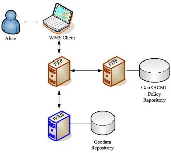
Annex C Example for protecting a OpenGIS® Web Service (informative) ...37
C.1 Example Infrastructure ...37
C.2 Managing Access to a WMS...38
C.2.1 Protect access to a particular layer for GetMap operations ...38
C.2.2 Protect access to a particular area using the GetMap operation ...39
C.2.3 Protect access to a particular area using the GetFeatureInfo operation ...40
C.3 Managing Access to a WFS ...42
C.3.1 Protect access to particular feature types using the GetFeature operation ...42
i.
Preface
The Policy Language introduced in this document defines a geo-specific extension to the OASIS standard “eXtensible Access Control Markup Language (XACML), Version 2.0” [1]. Due to the similarity of XACML version 2.0 to previous versions (e.g. 1.0 or 1.1), the extension described in this document also represents a valid extension for earlier XACML versions.
GeoXACML defines an extension to XACML for spatial data types and spatial authorization decision functions. Those data types and functions can be used to define additional spatial constraints for XACML based policies.
Beside a schema to encode policies, XACML includes a context schema that includes a specification of the generic data level interface to the XACML processor (PDP). Since GeoXACML defines extensions for the policy encoding schema only, it does not affect the XACML context schema and therefore does not include an interface specification of any kind.
In addition, XACML includes a model for an access control system. This incorporates stereotype definitions of a Policy Enforcement Point (PEP), Policy Decision Point (PDP), Policy Administration Point (PAP) and Policy Information Point (PIP) as well as their relations to each other in the context of an access control system. For the purpose of GeoXACML, the access control model is informative.
Attention is drawn to the fact that this document defines a rule based Policy Language suitable to express access rights. By using the GeoXACML Policy Language, an interoperable access control system for geospatial applications, such as Spatial Data Infrastructures, can be implemented. It is important to highlight that GeoXACML is not designed to be a Rights Expression Language.
Submitting organizations
The following organizations submitted this Implementation Specification to the Open Geospatial Consortium Inc. as a Request For Comment (RFC):
Universität der Bundeswehr München
Andreas Matheus
Werner-Heisenberg-Weg 39 D-85579 Neubiberg
Germany
andreas.matheus(at)unibw.de
Galdos Systems Inc.
Ron Lake
1300-409 Granville St Vancouver V6C 1T2 Canada
Rlake(at)galdosinc.com
ii.
Submission and contribution
contact points
All questions regarding this submission should be directed to the editor, the submitters or the contributors:
CONTACT COMPANY EMAIL
Andreas Matheus Universität der Bundeswehr München Andreas.Matheus(at)unibw.de
Ron Lake Galdos Systems Inc. rlake(at)galdosinc.com
Jan Herrmann Ludwig-Maximilians-Universität München jan.herrmann(at)lmu.de
John Herring Oracle USA john.herring(at)oracle.com
Martin Kyle Sierra Systems Group Inc. MartinKyle(at)SierraSystems.co
iii.
Revision history
Date Release Author Paragraph modified
Description
2007-01-22 0.1.0 Andreas Matheus All Initial Writing
2007-02-28 0.2.0 Andreas Matheus All Formatting
2007-03-19 0.3.0 Michael Mendonca All GML corrections
2007-08-06 – 2007-08-14
0.4.0 Jan Herrmann
Andreas Matheus
Incorporation of comments received during the 30 day period for public comment Adding more geo-specific definitions.
2007-08-16 0.5.0 John Herring 2, Annex A Description conformance classes
2007-08-22 0.6.0 Jan Herrmann
Andreas Matheus
Clarification of test cases, geometry collections and bag functions
2007-08-27 0.7.0 Jan Herrmann
Andreas Matheus
throughout Editorial corrections
2007-09-06 0.7.1 Martin Kyle throughout More editorial corrections
2007-9-21 – 2007-10-25
0.8.0 Jan Herrmann
Andreas Matheus
7,8,9, Annex A Incorporation of comments and decisions from the TC meeting 17.-21.9.2007
2007-10-29 0.8.1 Martin Kyle 7,8, Annex A,B Minor corrections, add Round Caps
2007-10-30 0.8.2 Jan Herrmann
Andreas Matheus
Martin Kyle
7,8,A,B Incorporation of comments from Martin Kyle and adding the Unit of Measure
“metre” for functions Buffer, Area, Distance, IsWithinDistance, Length
2007-11-5 0.8.3 John R. Herring Editing for English and Simple Features.
2007-11-8 0.8.4 Jan Herrmann
Andreas Matheus
Update for Unit of Measure and convert function, URN corrections
2007-11-9 0.8.5 John R. Herring
2007-11-12 0.8.6 Jan Herrmann
Andreas Matheus
Minor corrections
2007-11-13 0.8.7 Andreas Matheus 8.2.1
8.5
9.6
page ii
Correction of Buffer function
Correct title to “… conversion functions”
Insert of conversion function URNs
Insert of additional disclaimer
2007-11-16 0.9 Andreas Matheus throughout Final formatting
iv.
Changes to the OGC® Abstract Specification
The OpenGIS® Abstract Specification does not require changes to accommodate this standard.
Even though this document does not require the change of OGC specifications, there are potential change requests to the “OpenGIS® Web Service Common Implementation Specification” [11]. This is because GeoXACML can be used to establish an Access Control Mechanism to protect the access to OpenGIS Web Services (OWS). In that sense, an OWS can reply with error code exceptions, currently not defined in [11]. A Change Request to [11] shall be developed to specify exceptions, relevant in term of Access Control.
A Change Request to “Definition identifier URNs in OGC namespace” [15] is required to register the GeoXACML URN identifiers in the OGC context. In this Change Request, the following base identifiers are to be defined: “urn:ogc:def:dataType:geoxacml:1.0” and “urn:ogc:def:function:geoxacml:1.0”. This document and the existing extensions define all GeoXACML identifier URNs.
v.
Foreword
Attention is drawn to the possibility that some of the elements of this document may be the subject of patent rights. The Open Geospatial Consortium Inc. shall not be held responsible for identifying any or all such patent rights.
Recipients of this document are requested to submit, with their comments, notification of any relevant patent claims or other intellectual property rights of which they may be aware that might be infringed by any implementation of the standard set forth in this document, and to provide supporting documentation.
This document is not comprehensive in and of itself. Since this document defines an extension to an existing OASIS standard, as defined in [1]: “eXtensible Access Control Markup Language (XACML) Version 2.0”. Therefore, the OGC recommends that using this document ONLY together with [1].
This document is also the core specification of a multi-part specification. Therefore, it is only meaningful if used with AT LEAST one extension.
Normative Annex A defines the conformance tables.
Informative Annex C provides an example how to protect a WMS and WFS with geo-specific rights.
Please note that definitions taken from other specifications are shaded in 5% grey. They are included in the specification for the purpose of easy reading. However, the reader is urged to follow the references to the normative definitions.
vi.
Introduction
Even though much geographic information is freely accessible, there are strong
requirements for its protection and access control, such as for revisions or protection of confidential information. The need for managed access to geographic information is the result of many different driving forces including legal requirements and commercial interests.
In contrast to a "persistent protection mechanism," defined by the Geospatial Digital Rights Management Reference Model (GeoDRM-RM) to be a mechanism that "remains in force regardless of where the content of the original resource is located or
reproduced" (p. 25, [9]), an Access Control System manages access to information only until it is obtained by the user and stored on a local computer system. Thinking of a service oriented Spatial Data Infrastructure, a "persistent protection mechanism" (e.g. GeoDRM System) would manage access at the time (i) the user requests geographic information from the service and (ii) afterwards, when the geographic information is stored somewhere else. The limitations of an Access Control System are such that access is typically used for online control at the time the user initiates a request to the service or before the corresponding response is submitted to the user. After the (geographic)
information has left the service, it is no longer managed by the access control system. In the real world, one can find numerous use cases where the establishment of access control is sufficient. In these cases, the complexity of the security system can be reduced significantly by merely using an Access Control System. This is in contrast to the case for a Security System implementing a comprehensive rights management policy. That said, GeoXACML is complementary to GeoRM.
The eXtensible Access Control Markup Language (XACML) allows establishing an Access Control System that can be used to manage access for Service Oriented
Architectures (SOA). In that sense, XACML can be used to protect information by the declaration of rights through the specified Policy Language. Even though XACML is designed to be used as a multi-purpose language, it does not have the capabilities to express geo-specific constraints on access rights.
Language. GeoXACML allows managing access to geographic information and services in an interoperable way across jurisdictions.
Arguments for standardization from this perspective include:
o The need for interoperability of rules and policies, respectively, if harmonization of distributed or hierarchical policy sets is required (e.g. Geospatial Data
Infrastructure rules, INSPIRE rules, NSDI rules each refining the access rights for globally available web services)
o A common Policy Language as an important requirement to facilitate the development of sophisticated tools for access control systems
OpenGIS® Geospatial eXtensible Access Control Markup
Language (GeoXACML)
Implementation Specification
–
Version 1.0
1 Scope
The Geospatial eXtensible Access Control Markup Language (GeoXACML) defines an extension to the XACML Policy Language that supports the declaration and enforcement of access restrictions on geographic information.
The geospatial extension to XACML defined in this OGC standard is based on the extensibility points as introduced in section 8 (p. 89, [1]). In short, GeoXACML defines:
the geometry model on which the geometric data types in access rules have to be based on,
the different encoding languages for geometric data types (which are provided in the extensions to this core specification),
the testing functions for topological relationships between geometries, and
the geometric functions.
2 Conformance
Because GeoXACML uses the existing extension points of XACML, a GeoXACML Policy Language is based on the same XML Policy Schema as XACML. However, a GeoXACML Policy may include specific attribute data types and condition functions, which are defined in GeoXACML only. Therefore a PDP, supporting GeoXACML Policies SHALL be capable of performing authorization decisions on XACML policies; the opposite is not true.
In order to claim conformance with the GeoXACML specification, an implementation of a PDP SHALL be conform to:
(i) the XACML specification as stated in [1], section 10 AND
(ii) the normative sections of this document, in particular conformance tables, defined in Annex A and tests defined in Annex B AND
(iii) at least one geometry encoding as specified in an extension to this document and with the geometry model as defined in chapter 7 of this document1.
The implementation must pass conformance tests from different categories, as defined in Annex B.
[1] OASIS, eXtensible Access Control Markup Language (XACML) Version 2.0, 1 Feb 2005, http://docs.oasis-open.org/xacml/2.0/access_control-xacml-2.0-core-spec-os.pdf
[2] OASIS, eXtensible Access Control Markup Language (XACML) Version 2.0 - Policy XML Schema: access_control-xacml-2.0-policy-schema-os.xsd
[3] OASIS, eXtensible Access Control Markup Language (XACML) Version 2.0 - Context XML Schema: access_control-xacml-2.0-context-schema-os.xsd
[4] OGC, Open Geospatial Consortium Inc.: OpenGIS® Implementation Specification for Geographic information - Simple feature access - Part 1: Common architecture,
Version: 1.2.0, Date: 2006-10-05,
http://portal.opengeospatial.org/files/?artifact_id=18241
[5] National Institute of Standards and Technology (NIST), NIST Guide to SI Units: B. 9 Factors for units listed by kind of quantity or field of science,
4 Terms and definitions
For the purposes of this document, the following terms and definitions apply. Please note that terms and definitions taken from other specifications are informative and shaded 5% grey. They are included here for easy reading. For the normative definition, please follow the reference.
4.1 Terms and definitions from eXtensible Access Control Markup Language (XACML) Version 2.0
For the normative definitions, please see [1]. Access - Performing an action
Access control - Controlling access in accordance with a policy Action - An operation on a resource
Applicable policy - The set of policies and policy sets that governs access for a specific decision request
Attribute - Characteristic of a subject, resource, action or environment that may be referenced in a predicate or target (see also – named attribute)
Authorization decision - The result of evaluating applicable policy, returned by the PDP to the PEP. A function that evaluates to “Permit”, “Deny”, “Indeterminate” or
“NotApplicable", and (optionally) a set of obligations
Bag – An unordered collection of values, in which there may be duplicate values
Condition - An expression of predicates. A function that evaluates to "True", "False" or “Indeterminate”
Conjunctive sequence - a sequence of predicates combined using the logical „AND‟ operation
Context - The canonical representation of a decision request and an authorization decision
Context handler - The system entity that converts decision requests in the native request format to the XACML canonical form and converts authorization decisions in the
XACML canonical form to the native response format
Decision – The result of evaluating a rule, policy or policy set
Disjunctive sequence - a sequence of predicates combined using the logical „OR‟ operation
Effect - The intended consequence of a satisfied rule (either "Permit" or "Deny")
Environment - The set of attributes that are relevant to an authorization decision and are independent of a particular subject, resource or action
Named attribute – A specific instance of an attribute, determined by the attribute name and type, the identity of the attribute holder (which may be of type: subject, resource, action or environment) and (optionally) the identity of the issuing authority
Obligation - An operation specified in a policy or policy set that should be performed by the PEP in conjunction with the enforcement of an authorization decision
Policy - A set of rules, an identifier for the rule-combining algorithm and (optionally) a set of obligations. May be a component of a policy set
Policy administration point (PAP) - The system entity that creates a policy or policy set Policy-combining algorithm - The procedure for combining the decision and obligations from multiple policies
Policy decision point (PDP) - The system entity that evaluates applicable policy and renders an authorization decision. This term is defined in a joint effort by the IETF Policy Framework Working Group and the Distributed Management Task Force
(DMTF)/Common Information Model (CIM) in [RFC3198]. This term corresponds to "Access Decision Function" (ADF) in [ISO10181-3].
Policy enforcement point (PEP) - The system entity that performs access control, by making decision requests and enforcing authorization decisions. This term is defined in a joint effort by the IETF Policy Framework Working Group and the Distributed
Management Task Force (DMTF)/Common Information Model (CIM) in [RFC3198]. This term corresponds to "Access Enforcement Function" (AEF) in [ISO10181-3]. Policy information point (PIP) - The system entity that acts as a source of attribute values
Policy set - A set of policies, other policy sets, a policy-combining algorithm and (optionally) a set of obligations. May be a component of another policy set Predicate - A statement about attributes whose truth can be evaluated Resource - Data, service or system component
Rule - A target, an effect and a condition. A component of a policy
Subject - An actor whose attributes may be referenced by a predicate
5 Conventions
5.1 Symbols (and abbreviated terms)
1D One Dimensional
2D Two Dimensional
3D Three Dimensional
GeoXACML Geospatial eXtensible Access Control Markup Language GeoDRM Geospatial Digital Rights Management
GeoDRM-RM Geospatial Digital Rights Management – Reference Model
GML Geography Markup Language
ISO International Organization for Standardization
OASIS Organization for the Advancement of Structured Information Standards OGC Open Geospatial Consortium
OWS OpenGIS Web Services
PAP Policy Administration Point PDP Policy Decision Point PEP Policy Enforcement Point PIP Policy Information Point
SAML Security Assertion Markup Language SOA Service Oriented Architecture
UML Unified Modeling Language
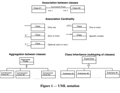
5.2 UML Notation
The diagrams that appear in this standard are presented using the Unified Modelling Language (UML) static structure diagram. The UML notations used in this standard are described in the diagram below.
Association between classes
Optional (zero or one )
1..*
Class #1 ComponentClass #2 ComponentClass #n
……….
0..*
0..1
Class Inheritance (subtyping of classes)
Superclass
Subclass #1
…………..
Subclass #2 Subclass #n
6 Brief Introduction to XACML (informative)
This chapter provides a brief informative introduction of XACML.
A short primer on XACML is available as a Technology Report at the OASIS Cover Pages; see [8] for more information.
The XACML standard can be separated into two main sections, which are introduced in more detail in the following sections: (i) Policy Language and Authorization Model as and (ii) Information Flow Model.
6.1 Policy Language Model and Authorization
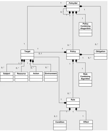
The XACML Policy Language Model defines an XML encoding for expressing general purpose access restrictions and extension points to define your own Attribute Values, Functions, etc. The entire set of access restrictions defines an XACML Policy. The Policy is structured, according to the following UML diagram (see Figure 2).
The top level element is the <PolicySet>. It can host zero or more <PolicySet> elements, which can be included inline or by reference. This powerful feature allows the reuse of pre-defined policy segments as well as the integration of multiple policies.
Each <PolicySet> element can host one or more <Policy> elements, which is the container for a set of <Rule> elements. Inside the <Rule> element, conditions can be formed to express complex access restrictions, using the <Condition> element.
Each <PolicySet>, <Policy> and <Rule> element have a <Target> element, which can be used to define simple matching conditions for the Subject, Action, Resource and
Environment. This allows the effective structuring of a policy into sub-trees, which eases the maintenance of rights defined in a policy. On the other hand, the simple matching in a <Target> element ensures fast decision making, when it comes to deriving an
authorization decision.
The flexible matching of Subjects in the <Target> element supports direct association of access rights to subjects or roles, as defined in the RBAC profile of XACML (“Core and hierarchical role based access control (RBAC) profile of XACML v2.0”,[6]).
The XACML Policy Language defines four different results for the authorization decision: (i) Permit, (ii) Deny, (iii) Indeterminate and (iv) NotApplicable. Finally, the process of deriving an authorization decision can result in an error, which is documented as additional information in the <Decision> element.
In addition, the decision can be “Permit with Obligation”, which can be expressed in the <Obligation> element, attached to the <Policy> or <PolicySet> element.
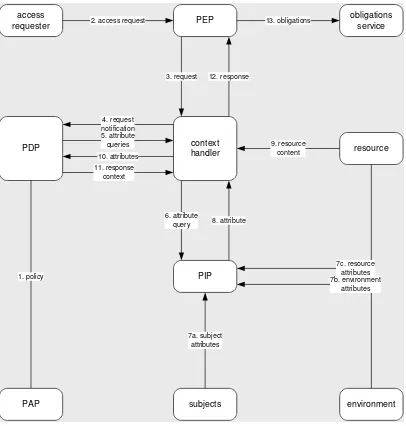
6.2 Information Flow Model
The XACML Information Flow Model defines the architecture of a modular and distributed access control system. In addition, it defines the exchange of messages between the components and the structure of the messages. The following figure illustrates the informative architecture and the sequence of messages, sent between the components of the access control system.
The Policy Administration Point (PAP) is the component that allows one or multiple policy administrators to maintain access rights in a set of policies. In addition, the PAP might provide an interface for requesting policies, as it is defined in the “SAML 2.0 profile of XACML v2.0” of the XACML standard (see [7]).
The Policy Decision Point (PDP) is the component that derives an authorization decision based on a request, received from one or multiple Policy Enforcement Point(s) (PEP). A PDP may request policies from the PAP or use a policy repository on file or in a
database.
The Policy Enforcement Point (PEP) can be characterized as a binary switch that either forwards the intercepted request from the client to the service (and the response from the service to the client respectively) or replies with an adequate error message. The decision if the request or response is to be forwarded or blocked depends on the authorization decisions, received from the PDP. Because the PEP must request authorization decisions in a particular XACML message format, it is the duty of the context handler to collect all relevant information and prepare the authorization decision request message. The
information, collected by the context handler can include the identity information about the user, the action to be taken on the resource, information about the resource itself, the IP address of the client, the time of the request, certificate information, etc… In order to collect all relevant information, it can be required to request such information from the Policy Information Point (PIP).
6.3 Extension capabilities of XACML
The XACML specification defines the non-normative extensibility points (section 8, [1]). For this specification, it is important to note that the DataType,FunctionId and
AttributeId can be extended.
Please see the XACML schema definitions in access_control-xacml-2.0-policy-schema-os.xsd ([2]) for the XML format of the elements.
6.3.1 Defining new Data Types
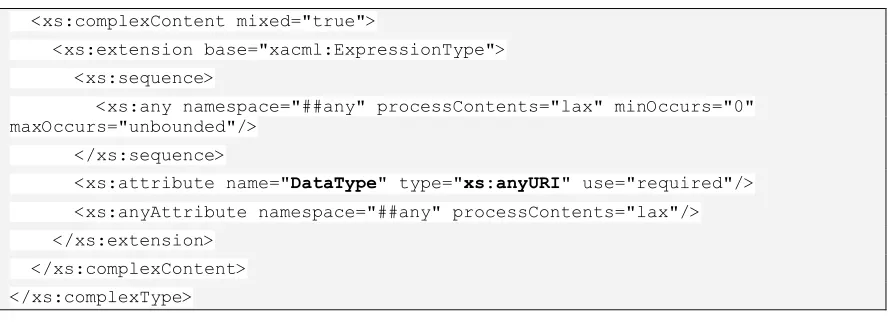
An <AttributeValue> element has an attribute named DataType, which is of type xs:anyURI. According to the extension capabilities of XACML, additional attribute values can be defined by associating a unique DataType identifier to it.
Section 8.2 of the XACML specification states that “<xacml:AttributeValue> and
<xacml-context:AttributeValue> elements MAY contain an instance of a structured XML data-type.”.
This capability allows the definition of geometry data types, as defined by GeoXACML.
<xs:complexContent mixed="true">
<xs:extension base="xacml:ExpressionType"> <xs:sequence>
<xs:any namespace="##any" processContents="lax" minOccurs="0" maxOccurs="unbounded"/>
</xs:sequence>
<xs:attribute name="DataType" type="xs:anyURI" use="required"/> <xs:anyAttribute namespace="##any" processContents="lax"/> </xs:extension>
</xs:complexContent> </xs:complexType>
Figure 4 — XACML schema definition of the <AttributeValue> element
6.3.2 Defining new Functions
A <Function> element has an attribute named FunctionId, which is of type xs:anyURI. According to the extension capabilities of XACML, additional functions can be defined by associating a unique FunctionId to it.
This capability allows the definition of geo-specific functions, as defined by GeoXACML.
<xs:element name="Function" type="xacml:FunctionType"/> <xs:complexType name="FunctionType">
<xs:attribute name="FunctionId" type="xs:anyURI" use="required"/> </xs:complexType>
Figure 5 — XACML schema definition of the <Function> element
6.3.3 Defining new Identifiers / Attributes
An <AttributeDesignator> element allows fetching information from an XACML
AuthorizationDecisionRequest based on named attributes. In order to specify new
names for attributes, the <AttributeDesignatorType> has an attribute named AttributeId. In order to use GeoXACML specific data types, the value of the attribute
DataType SHALL be used according to the specified data types. According to the extension capabilities of XACML, additional identifier-names or attribute-names can be defined by associating a unique AttributeId to it.
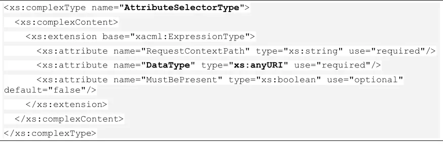
An <AttributeSelector> element allows fetching information from an XACML
AuthorizationDecisionRequest based on the XML encoded information as it can be
inserted into the <ResourceContent> element. The value of the attribute named
These capabilities allow the fetching of geo-specific information using either the XACML AttributeDesignator or the AttributeSelector without modifying any XACML schema (policy or authorization decision request schema).
The following two figures highlight the extension points in the XACML schema that are used by GeoXACML.
<xs:complexType name="AttributeDesignatorType"> <xs:complexContent>
<xs:extension base="xacml:ExpressionType">
<xs:attribute name="AttributeId" type="xs:anyURI" use="required"/> <xs:attribute name="DataType" type="xs:anyURI" use="required"/> <xs:attribute name="Issuer" type="xs:string" use="optional"/> <xs:attribute name="MustBePresent" type="xs:boolean" use="optional" default="false"/>
</xs:extension> </xs:complexContent>
</xs:complexType>
Figure 6 — XACML schema definition of the <AttributeDesignatorType> element
<xs:complexType name="AttributeSelectorType"> <xs:complexContent>
<xs:extension base="xacml:ExpressionType">
<xs:attribute name="RequestContextPath" type="xs:string" use="required"/> <xs:attribute name="DataType" type="xs:anyURI" use="required"/>
<xs:attribute name="MustBePresent" type="xs:boolean" use="optional" default="false"/>
</xs:extension> </xs:complexContent>
</xs:complexType>
7 GeoXACML Geometry Model (normative)
This chapter describes the GeoXACML core geometry model. It is separated from the encoding for geometries that are used in GeoXACML policy declarations. Please note that the actual XML encoding of these geometries can vary. Therefore, this standard provides multiple extension parts in which a particular encoding is defined.
Any conformant implementation for GeoXACML SHALL support at least one geometry schema encoding (introduced in the extension parts of this document) supporting the geometry types listed below.
In this standard, the underlying geometry models of all geometry schema encodings in the extension parts are based on the geometry definitions as specified in the OpenGIS® Implementation Specification for Geographic information - Simple feature access - Part 1: Common architecture, Version: 1.2.0 ([4]).
In order to support a flexible and straight forward solution for allowing geometric data types that easily comply with the base XACML specification, GeoXACML extends XACML by only one new data type that is named
“urn:ogc:def:dataType:geoxacml:1.0:geometry”.
This implies that the data type of every geometric attribute value, bag of geometric values or pointers to geometric data (i.e. AttributeSelector or AttributeDesignator) in a
GeoXACML policy SHALL always be “urn:ogc:def:dataType:geoxacml:1.0:geometry”.
By using a super class for all geometric data types (see [4]) as the only spatial data type in GeoXACML, this standard remains “stable” even if new extensions parts are added. Additionally, the use of the geometric super class as the only new data type in
GeoXACML simplifies the declaration of the function signatures as well as the implementation of GeoXACML conformant access control systems.
As all extensions are based on the underlying geometry model of [4], the specific values for a geometry <AttributeValue> of data type
“urn:ogc:def:dataType:geoxacml:1.0:geometry” must be represented by of one of the following basic types:
Remark: The definitions are listed here for easy reading. For the normative definitions, please see [4] .
Polygon - A Polygon is a planar Surface defined by 1 exterior boundary and 0 or more interior boundaries. Each interior boundary defines a hole in the Polygon.
MultiPoint - A MultiPoint is a 0-dimensional GeometryCollection. The elements of a MultiPoint are restricted to Points.
MultiLineString -A MultiLineString is a MultiCurve whose elements are LineStrings. MultiPolygon - A MultiPolygon is a MultiSurface whose elements are Polygons.
Geometries as listed above SHALL be represented as a child node of an
<AttributeValue> element. Regardless of the type of the enclosed geometry, the “DataType” attribute of the <AttributeValue> element SHALL be set to
“urn:ogc:def:dataType:geoxacml:1.0:geometry”. The encoding of the enclosed geometry SHALL conform to the syntax as specified in the chosen encoding extension.
As defined in [4], a geometry might be empty. The encoding of an empty geometry SHALL be compliant with the definition in the relevant extension. If necessary, an empty geometry can also be represented as an empty <AttributeValue> of data type
“urn:ogc:def:dataType:geoxacml:1.0:geometry”:
<AttributeValue DataType=”urn:ogc:def:dataType:geoxacml:1.0:geometry”/>.
8 GeoXACML Spatial Function Definitions (normative)
Each of the following relational and geometric operators is supported by GeoXACML, in at least one of the conformance classes defined in Annex A. Their definition is based on the OpenGIS® Implementation Specification for Geographic information - Simple feature access - Part 1: Common architecture, Version: 1.2.0 ([4]).
In case a GeoXACML defined function returns a bag of geometries, the implementation SHALL provide this as a Bag of data type
“urn:ogc:def:dataType:geoxacml:1.0:geometry”. The same applies if one explicitly defines a bag of geometries in a policy. Note that all common Bag and Set Functions (see 8.3 and 8.4) can be used on Bags of data type
“urn:ogc:def:dataType:geoxacml:1.0:geometry”.
If the geometric operator returns an empty Bag, this is to be represented as an empty Bag of data type “urn:ogc:def:dataType:geoxacml:1.0:geometry”.
All geometries, explicitly defined in a <Rule> element of a GeoXACML policy SHALL use only one encoding extension to this standard.
In GeoXACML, the internal unit of length is metres and the internal unit of area is square metres. Accordingly, length or area values that are either a function parameter or the result of a function, are based on GeoXACML‟s internal unit of length or area. In use cases, where the distance / area is specified in a different unit of measure, a conversion SHALL be achieved using the functions as defined in 8.5.
All defined functions SHALL return a XACML ProcessingError with the state INDETERMINATE if
the XML encoded data type of the argument g is invalid or not suitable for the function according to the definition in [4], or
the processing of the underlying functionality results in an error.
In addition, all defined functions with two arguments g1 and g2 of any geometric data type SHALL return a XACML ProcessingError with the state INDETERMINATE if
the combination of data types for g1 and g2 is invalid according to the definition in [4].
the Coordinate Reference System definitions for g1 and g2 are both explicitly given but their values are different and the implementation does not support a CRS-transformation at runtime.
8.1 Definition of Topological Functions
All functions defined in this section SHALL take two arguments of data type “urn:ogc:def:dataType:geoxacml:1.0:geometry” and return a value of data type “http://www.w3.org/2001/XMLSchema#boolean”. In the following definitions, a geometry is treated as a representation of a possibly infinite set of points. The
representations obviously are not infinite, but use a variety of interpolation algorithms.
Contains(g1:Geometry, g2:Geometry) : Boolean
This function SHALL return a TRUE value if and only if the geometry g2 lies in the closure (boundary union interior) of geometry g1 – the inverse of Within(g1:Geometry, g2:Geometry).
Crosses(g1:Geometry, g2:Geometry) : Boolean
This function SHALL return a TRUE value if and only if the geometries g1 and g2 share some but neither is contained in the other, and the dimension of the intersection is less than that of both of the geometries.
Disjoint(g1:Geometry, g2:Geometry ) : Boolean
This function SHALL return a TRUE value if and only if the geometries g1 and g2 have no point in common.
Equals(g1:Geometry, g2:Geometry) : Boolean
This function SHALL return a TRUE value if and only if the geometries g1 and g2 are equal (geometrically contain exactly the same points).
Intersects(g1:Geometry, g2:Geometry) : Boolean
This function SHALL return a TRUE value if and only if the geometries g1 and g2 have at least one point in common (the inverse of Disjoint).
Overlaps(g1:Geometry, g2:Geometry) : Boolean
This function SHALL return a TRUE value if and only if the geometries g1 and g2 share some but not all points in common, and the intersection has the same dimension as the geometries themselves.
Touches(g1:Geometry, g2:Geometry) : Boolean
This function SHALL return a TRUE value if and only if the geometries g1 and g2 have at least one boundary point in common, but no interior points.
Within(g1:Geometry, g2:Geometry) : Boolean
8.2 Definition of Geometric Functions
8.2.1 Definition of Constructive Geometric Functions
Buffer(g:Geometry, d:Double) : Bag
This function SHALL take two arguments of data type “urn:ogc:def:dataType:geoxacml:1.0:geometry” and “http://www.w3.org/2001/XMLSchema#double.
This function SHALL return a bag of geometry values representing the buffer of geometry g at distance d. The buffer of a geometry at distance d is the Polygon or MultiPolygon which contains all points within a distance d of the geometry. The unit of measure for the argument d SHALL be metre.
Boundary(g:Geometry) : Bag
This function SHALL take one argument of data type
“urn:ogc:def:dataType:geoxacml:1.0:geometry” and return a Bag of geometries.
This function SHALL return a bag of geometry values representing the combinatorial boundary of geometry g.
ConvexHull(g:Geometry) : Geometry
This function SHALL take one argument of data type
“urn:ogc:def:dataType:geoxacml:1.0:geometry” and return a value of the same data type.
This function SHALL return a geometric object that represents the convex hull of
geometry g. The convex hull is the smallest convex polygon that contains all points of the geometry. The convex Hull for a geometry of encoding data type Point is the point itself.
Centroid(g:Geometry) : Geometry
This function SHALL take one argument of data type
“urn:ogc:def:dataType:geoxacml:1.0:geometry” and return a value of the same data type. This function SHALL return the point that is the geometric centre of gravity of the geometry g.
Difference(g1:Geometry, g2:Geometry) : Bag This function SHALL take two arguments of data type
“urn:ogc:def:dataType:geoxacml:1.0:geometry” and return a Bag of geometries.
This function SHALL return a bag of geometry values representing the closure of the set difference between the two geometries g1 and g2. The difference is the set of all points which lie on g1 but not on g2.
SymDifference(g1:Geometry, g2:Geometry) : Bag This function SHALL take two arguments of data type
This function SHALL return a bag of geometry values representing the closure of the symmetric difference of two Geometries. The symmetric difference is the set of points which lie on either g1 or g2 but not in both.
Intersection(g1:Geometry, g2:Geometry) : Bag This function SHALL take two arguments of data type
“urn:ogc:def:dataType:geoxacml:1.0:geometry” and return a Bag of geometries.
This function SHALL return a bag of geometry values representing the Point set intersection of geometry g1 and geometry g2.
Union(g1:Geometry, g2:Geometry) : Bag
This function SHALL take two arguments of data type
“urn:ogc:def:dataType:geoxacml:1.0:geometry” and return a Bag of geometries.
This function SHALL return a bag of geometry values representing a Point set union of geometry g1 with geometry g2.
8.2.2 Definition of Scalar Geometric Functions
Area(g:Geometry) : Double
This function SHALL take one argument of data type
“urn:ogc:def:dataType:geoxacml:1.0:geometry” and return value of data type“http://www.w3.org/2001/XMLSchema# double”.
This function SHALL return a value representing the area of geometry g The unit of measure for the return value SHALL be square metre. This function SHALL return zero for a geometry of encoding data type Point or LineString.
Distance(g1:Geometry, g2:Geometry) : Double This function SHALL take two arguments of data type
“urn:ogc:def:dataType:geoxacml:1.0:geometry” and return value of data type “http://www.w3.org/2001/XMLSchema# double”.
This function SHALL return a value representing the shortest distance in metre between any two points in the two geometries g1 and g2.
Because the geometries are closed, it is possible to find a point on each geometric object involved, such that the distance between these 2 points is the returned distance between their geometric objects.
IsWithinDistance(g1:Geometry, g2:Geometry, d:Double) : Boolean This function SHALL take two arguments of data type
This function SHALL return a TRUE value if and only if the shortest distance between the geometries g1 and g2 is less than or equal to a specified distance d in metre.
Length(g:Geometry) : Double
This function SHALL take one argument of data type
“urn:ogc:def:dataType:geoxacml:1.0:geometry” and return value of data type “http://www.w3.org/2001/XMLSchema# double”.
This function SHALL return a value representing the length of geometry g. The unit of measure for the return value SHALL be metre. This function SHALL return zero for a geometry of encoding data type Point. This function SHALL return the perimeter for a geometry of encoding data type Polygon.
8.2.3 Definition of Functions to check special characteristics
All functions defined in this section SHALL take one argument of data type “urn:ogc:def:dataType:geoxacml:1.0:geometry” and return value of data type “http://www.w3.org/2001/XMLSchema#boolean”.
IsSimple(g:Geometry) : Boolean
This function SHALL return a TRUE value if and only if geometry g has no anomalous geometric points, such as self intersection or self tangency. Simple curves intersect themselves only at their endpoints (only if they are also closed, see next function).
IsClosed(g:Geometry) : Boolean
This function SHALL return a TRUE value for a curve g if and only if the start and end point of the curve g are identical. For a point, a finite set of points or an empty geometry this function SHALL return TRUE. Surfaces require a 3D space to close. In general, a closed geometry has an empty boundary.
IsValid(g:Geometry) : Boolean
This function SHALL return a TRUE value if and only if the geometry g is valid as specified in [4].
8.3 Definition of Bag Functions
GeometryOneAndOnly(b: Bag) : Geometry
This function SHALL take a bag with values of data type Geometry as an argument and SHALL return a value of data type “urn:ogc:def:dataType:geoxacml:1.0:geometry”.
This function SHALL return the value of the only element in the bag b.
This function SHALL return a XACML ProcessingError with state INDETERMINATE if the geometry bag b does not have exactly one value.
GeometryBagSize(b: Bag) : Integer
This function SHALL take a bag with values of data type
“urn:ogc:def:dataType:geoxacml:1.0:geometry”as an argument and SHALL return a value of data type “http://www.w3.org/2001/XMLSchema#integer”.
This function SHALL return a value indicating the number of elements in the bag. GeometryIsIn(g:Geometry, b: Bag) : Boolean
This function SHALL take as argument a value of data type
“urn:ogc:def:dataType:geoxacml:1.0:geometry”as the first argument, a bag with values of data type “urn:ogc:def:dataType:geoxacml:1.0:geometry”as the second argument and SHALL return an “http://www.w3.org/2001/XMLSchema#boolean”.
The function SHALL return a TRUE value if and only if the first argument matches by the function “urn:ogc:def:function:geoxacml:1.0:geometry-equals” any value in the bag.
GeometryBag(g*:Geometry) : Bag
This function SHALL take any number of arguments whose values are all of data type “urn:ogc:def:dataType:geoxacml:1.0:geometry”and return a bag of geometries containing the values of the arguments.
An application of this function to zero arguments SHALL produce an empty bag of data-type “urn:ogc:def:dataType:geoxacml:1.0:geometry”.
8.4 Definition of Set Functions
These functions operate on bags of data type
“urn:ogc:def:dataType:geoxacml:1.0:geometry” mimicking sets by eliminating duplicate elements from a geometry bag.
GeometryBagIntersection(b1: Bag, g2: Bag) : Bag
This function SHALL take two arguments that are both a bag of data type “urn:ogc:def:dataType:geoxacml:1.0:geometry”.
This function SHALL return a bag of data type
“urn:ogc:def:dataType:geoxacml:1.0:geometry” such that it contains only elements that are common between the bags b1 and b2, which is determined by
"urn:ogc:def:function:geoxacml:1.0:geometry-equals". No duplicates, as determined by "urn:ogc:def:function:geoxacml:1.0:geometry-equals", SHALL exist in the result. GeometryBagAtLeastOneMemberOf(b1: Bag, b2: Bag) : Boolean
This function SHALL take two arguments that are both a bag of data type “urn:ogc:def:dataType:geoxacml:1.0:geometry” and SHALL return a “http://www.w3.org/2001/XMLSchema#boolean”.
The function SHALL evaluate to TRUE if and only if at least one element of the bag b1 is contained in the second bag b2 as determined by
“urn:ogc:def:function:geoxacml:1.0:geometry-is-in”.
GeometryBagUnion(b1: Bag, b2: Bag) : Bag
This function SHALL take two arguments that are both a bag of data type “urn:ogc:def:dataType:geoxacml:1.0:geometry”.
This function SHALL return a bag of data type
“urn:ogc:def:dataType:geoxacml:1.0:geometry” such that it contains all elements of both bags b1 and b2. No duplicates, as determined by
"urn:ogc:def:function:geoxacml:1.0:geometry-equals", SHALL exist in the result.
GeometryBagSubset(b1: Bag, b2: Bag) : Boolean
This function SHALL take two arguments that are both a bag of data type “urn:ogc:def:dataType:geoxacml:1.0:geometry” and SHALL return a “http://www.w3.org/2001/XMLSchema#boolean”.
This function SHALL return a TRUE value if and only if the bag b1 is a subset of the bag b2. Each argument SHALL be considered to have had its duplicates removed, as
determined by "urn:ogc:def:function:geoxacml:1.0:geometry-equals", before the subset calculation.
GeometrySetEquals(b1: Bag, b2: Bag) : Boolean
type“urn:ogc:def:dataType:geoxacml:1.0:geometry” and SHALL return a “http://www.w3.org/2001/XMLSchema#boolean”.
This function SHALL return the result of applying "urn:oasis:names:tc:xacml:1.0:func-tion:and" to the application of "urn:ogc:def:function:geoxacml:1.0:geometry-bag-subset" to bag b1 and bag b2 and the application of "urn:ogc:def:function:geoxacml:1.0:geo-metry-bag-subset" to bag b2 and bag b1.
8.5 Definition of Conversion Functions
As stated before, in GeoXACML the only internal unit of length is metre and the only internal unit of area is square metre. This implies that all length / area arguments in rules that are based on different units of measure have to be converted into metre / square metre, before they are processed by the corresponding functions (e.g. IsWithinDistance or Buffer function). This can be achieved by using the appropriate conversion function as defined below.
ConvertToMetre(d:Double, u:String) : Double
This function SHALL take one argument of data type “http:/ /www.w3.org/2001/XML-Schema#double” and one argument of data type http://www.w3.org/2001/XML -Schema#string, representing a length unit of measure. This function SHALL return a value of data type “http://www.w3.org/2001/XMLSchema# double”.
This function converts the distance value d given in the unit of measure u into the corresponding distance value based on the basic unit metre.
This function SHALL return a XACML ProcessingError with state INDETERMINATE if the unit of measure, as given by the parameter u, cannot be converted to metre.
ConvertToSquareMetre(a:Double, u:String) : Double This function SHALL take one argument of data type
“http://www.w3.org/2001/XMLSchema# double” and one argument of data type
http://www.w3.org/2001/XMLSchema#string, representing an area unit of measure. This function SHALL return a value of data type “http://www.w3.org/2001/XMLSchema# double”.
This function converts the area value a given in the unit of measure u into the corresponding area value based on the basic unit square metre.
This function SHALL return a XACML ProcessingError with state INDETERMINATE if the unit of measure, as given by the parameter u, cannot be converted to square metre.
9 GeoXACML Identifier Definitions (normative)
The implementation MUST use the attributes associated with the following identifiers in the way GeoXACML has defined. The second column in the tables refers to the name of the functions as used in Chapter 8 of this specification or in [1].
9.1 Identifier for Geometry
The following identifier SHALL be used to reference the geometric data type Geometry.
URN Data Type
urn:ogc:def:dataType:geoxacml:1.0:geometry Geometry Table 1 — GeoXACML Geometry URN
In order to construct geometric data types using a specific encoding scheme, GeoXACML defines more URNs in the existing extensions.
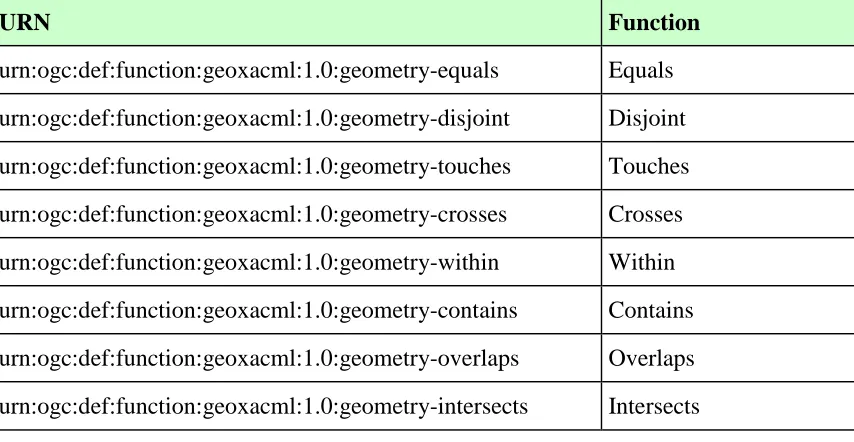
9.2 Identifiers for Topological Functions
In order to define functions for testing topological relations, GeoXACML defines the following URNs.
URN Function
urn:ogc:def:function:geoxacml:1.0:geometry-equals Equals urn:ogc:def:function:geoxacml:1.0:geometry-disjoint Disjoint urn:ogc:def:function:geoxacml:1.0:geometry-touches Touches urn:ogc:def:function:geoxacml:1.0:geometry-crosses Crosses urn:ogc:def:function:geoxacml:1.0:geometry-within Within urn:ogc:def:function:geoxacml:1.0:geometry-contains Contains urn:ogc:def:function:geoxacml:1.0:geometry-overlaps Overlaps urn:ogc:def:function:geoxacml:1.0:geometry-intersects Intersects
9.3 Identifiers for Geometric Functions
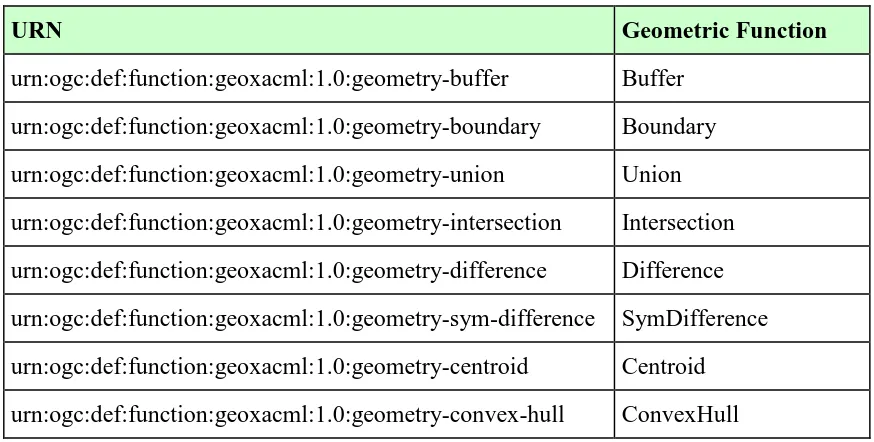
In order to express and enforce more complex access restrictions based on spatial analysis, GeoXACML defines the following geometric function URNs.
9.3.1 Identifiers for Constructive Geometric Functions
URN Geometric Function
urn:ogc:def:function:geoxacml:1.0:geometry-buffer Buffer urn:ogc:def:function:geoxacml:1.0:geometry-boundary Boundary urn:ogc:def:function:geoxacml:1.0:geometry-union Union urn:ogc:def:function:geoxacml:1.0:geometry-intersection Intersection urn:ogc:def:function:geoxacml:1.0:geometry-difference Difference urn:ogc:def:function:geoxacml:1.0:geometry-sym-difference SymDifference urn:ogc:def:function:geoxacml:1.0:geometry-centroid Centroid urn:ogc:def:function:geoxacml:1.0:geometry-convex-hull ConvexHull
Table 3 — Constructive geometric function URNs
9.3.2 Identifiers for Scalar Geometric Functions
URN Geometric Function
urn:ogc:def:function:geoxacml:1.0:geometry-distance Distance
urn:ogc:def:function:geoxacml:1.0:geometry-is-within-distance IsWithinDistance urn:ogc:def:function:geoxacml:1.0:geometry-length Length
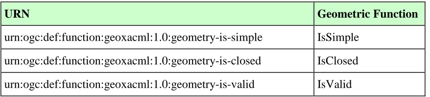
9.3.3 Identifiers for Miscellaneous Geometric Functions
URN Geometric Function
urn:ogc:def:function:geoxacml:1.0:geometry-is-simple IsSimple urn:ogc:def:function:geoxacml:1.0:geometry-is-closed IsClosed urn:ogc:def:function:geoxacml:1.0:geometry-is-valid IsValid
Table 5 — Miscellaneous geometric function URNs
9.4 Identifiers for Bag Functions for XACML Bags containing Geometries
In order to operate on bags containing geometries, GeoXACML defines the following geometric bag function URNs.
Remark: GeoXACML does not define new Bag Functions but leverages the Bag Functions for geometries as defined in the XACML specification (see [1], A.3.10).
URN Bag Function
urn:ogc:def:function:geoxacml:1.0:geometry-one-and-only GeometryOneAndOnly urn:ogc:def:function:geoxacml:1.0:geometry-bag-size GeometryBagSize urn:ogc:def:function:geoxacml:1.0:geometry-is-in GeometryIsIn urn:ogc:def:function:geoxacml:1.0:geometry-bag GeometryBag
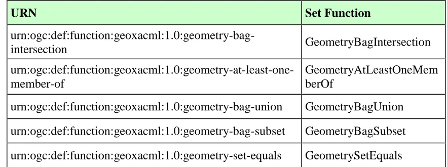
9.5 Identifiers for geometric Set Functions
In order to analyse geometric bags, GeoXACML defines the following geometric set function URNs.
URN Set Function
urn:ogc:def:function:geoxacml:1.0:geometry-bag-intersection GeometryBagIntersection
urn:ogc:def:function:geoxacml:1.0:geometry-at-least-one-member-of
GeometryAtLeastOneMem berOf
urn:ogc:def:function:geoxacml:1.0:geometry-bag-union GeometryBagUnion urn:ogc:def:function:geoxacml:1.0:geometry-bag-subset GeometryBagSubset urn:ogc:def:function:geoxacml:1.0:geometry-set-equals GeometrySetEquals
Table 7 — Geometric Set Function URNs
9.6 Identifiers for conversion Functions
In order to convert units of measure, GeoXACML defines the following conversion function URNs.
URN Set Function
urn:ogc:def:function:geoxacml:1.0:convert-to-metre ConvertToMetre
urn:ogc:def:function:geoxacml:1.0:convert-to-square-metre ConvertToSquareMetre
Annex A GeoXACML Conformance Tables (normative) This Annex defines which GeoXACML attribute, identifier, data type and function definitions are mandatory to be implemented toward BASIC or STANDARD conformance.
Note: "I" means to be implemented toward BASIC conformance. "II" means to be
implemented in addition to “I” towards STANDARD conformance.
A.1 Schema elements
GeoXACML does not define any new schema elements. Any conformant GeoXACML process MUST be able to prove XACML conformance
A.2 Identifier Prefixes
The following identifier prefixes are reserved by GeoXACML.
Note: Because they are part of the GeoXACML URN definitions, they MUST therefore be implemented in the BASIC conformance class.
Identifier
urn:ogc:def:dataType:geoxacml:1.0:geometry urn:ogc:def:function:geoxacml:1.0
Any conformant GeoXACML process MUST be able to pass tests as defined in Annex B which include these identifier prefixes.
A.3 Algorithms
GeoXACML does not define any new algorithms.
A.4 Status Codes
GeoXACML does not define any new status codes.
A.5 Data Type
Data Type Conformance
Class
A.6 Functions
In order to pass the BASIC conformance level, an implementation MUST process ALL function URNs marked “I” for ALL test cases defined in Annex B.3.
In order to pass the STANDARD conformance level, an implementation MUST process ALL function URNs marked “II” for ALL test cases defined in Annex B.3.
A.6.1 Topological Functions
Functions Conformance
Class
urn:ogc:def:function:geoxacml:1.0:geometry-equals I
urn:ogc:def:function:geoxacml:1.0:geometry-disjoint I
urn:ogc:def:function:geoxacml:1.0:geometry-touches I
urn:ogc:def:function:geoxacml:1.0:geometry-crosses I
urn:ogc:def:function:geoxacml:1.0:geometry-within I
urn:ogc:def:function:geoxacml:1.0:geometry-contains I
urn:ogc:def:function:geoxacml:1.0:geometry-overlaps I
urn:ogc:def:function:geoxacml:1.0:geometry-intersects I
Any BASIC level conformant GeoXACML process MUST be able to pass tests as defined in B.5 which include all of the functions above.
A.6.2 Bag Functions
Functions Conformance
Class urn:ogc:def:function:geoxacml:1.0:geometry-one-and-only I
urn:ogc:def:function:geoxacml:1.0:geometry-bag-size I
urn:ogc:def:function:geoxacml:1.0:geometry-is-in I
urn:ogc:def:function:geoxacml:1.0:geometry-bag I
A.6.3 Set Functions
Functions Conformance
Class urn:ogc:def:function:geoxacml:1.0:geometry-bag-intersection I
urn:ogc:def:function:geoxacml:1.0:geometry-bag-at-least-one-member-of I
urn:ogc:def:function:geoxacml:1.0:geometry-bag-union I
urn:ogc:def:function:geoxacml:1.0:geometry-bag-subset I
urn:ogc:def:function:geoxacml:1.0:geometry-set-equals I
Any BASIC level conformant GeoXACML process MUST be able to pass tests as defined in B.5 which include all of the functions above.
A.6.4 Geometric Functions
Functions Conformance
Class
urn:ogc:def:function:geoxacml:1.0:geometry-buffer II
urn:ogc:def:function:geoxacml:1.0:geometry-boundary II
urn:ogc:def:function:geoxacml:1.0:geometry-convex-hull II
urn:ogc:def:function:geoxacml:1.0:geometry-centroid II
urn:ogc:def:function:geoxacml:1.0:geometry-difference II urn:ogc:def:function:geoxacml:1.0:geometry-sym-difference II urn:ogc:def:function:geoxacml:1.0:geometry-intersection II
urn:ogc:def:function:geoxacml:1.0:geometry-union II
urn:ogc:def:function:geoxacml:1.0:geometry-area II
urn:ogc:def:function:geoxacml:1.0:geometry-distance II
urn:ogc:def:function:geoxacml:1.0:geometry-is-within-distance II
urn:ogc:def:function:geoxacml:1.0:geometry-length II
urn:ogc:def:function:geoxacml:1.0:geometry-is-simple II
urn:ogc:def:function:geoxacml:1.0:geometry-is-closed II
Any STANDARD level conformant GeoXACML process MUST be able to pass tests as defined in B.5 which include all of the functions above.
A.6.5 Conversion Functions
Functions Conformance
Class
urn:ogc:def:function:geoxacml:1.0:convert-to-metre I
urn:ogc:def:function:geoxacml:1.0:convert-to-square-metre I
For the function “urn:ogc:def:function:geoxacml:1.0:convert-to-metre” any BASIC level conformance GeoXACML process SHALL support all possible conversions to metre, as listed in [5], table “LENGTH”.
Annex B GeoXACML Conformance Definition and Tests (normative) This section lists those portions of the specification that SHALL be satisfied in an implementation of a PDP that claims conformance with GeoXACML v1.0.
Because the conformance to GeoXACML relies on the conformance to XACML, it is strongly recommended that the implementation satisfies all tests defined in [14].
B.1 Conformance Class Definition
GeoXACML has two conformance classes:
a) The BASIC (I) conformance class, which MUST be satisfied by all PDP implementations, consists of ALL tests for ALL definitions that are label “I”. b) The STANDARD (II) conformance class MUST satisfy the BASIC class tests
and MUST further satisfy ALL tests for ALL definitions that are label “II”.
B.2 Aspect Definitions
GeoXACML has two different aspect groups for testing:
Aspect group A: Data Type
Aspect group B: Function
The individual aspects for each group are defined in section 9 of this specification and in the used extension(s).
B.3 Conformance Test Case Definitions
Each test in the test suite will be associated to a particular requirement or constraint in this standard (the aspect), and the test format will follow the following pattern:
1. Test Purpose: To determine if the candidate process satisfies a particular aspect of this standard. For BASIC conformance, only BASIC aspects will be included in the test sample instance For STANDARD conformance, any aspects from BASIC AND STANDARD conformance SHALL be included in the test sample instance.
2. Test Method: A GeoXACML instance document using that particular aspect(s) will be present for processing, and the process should respond properly
3. Reference: Each test will reference the aspect to be tested