RICE YIELD ESTIMATION THROUGH ASSIMILATING SATELLITE DATA INTO A
CROP SIMUMLATION MODEL
N.T. Son *, C.F. Chen, C.R. Chen, L.Y. Chang, S.H. Chiang
Center for Space and Remote Sensing Research, National Central University, Jhongli District, Taoyuan City 32001, TAIWAN
[email protected], [email protected], [email protected], [email protected], [email protected]
Commission WG VIII/8
KEY WORDS: Data assimilation, remote sensing, crop simulation model, rice yield.
ABSTRACT:
Rice is globally the most important food crop, feeding approximately half of the world’s population, especially in Asia where around half of the world’s poorest people live. Thus, advanced spatiotemporal information of rice crop yield during crop growing season is critically important for crop management and national food policy making. The main objective of this study was to develop an approach to integrate remotely sensed data into a crop simulation model (DSSAT) for rice yield estimation in Taiwan. The data assimilation was processed to integrate biophysical parameters into DSSAT model for rice yield estimation using the particle swarm optimization (PSO) algorithm. The cost function was constructed based on the differences between the simulated leaf area index (LAI) and MODIS LAI, and the optimization process starts from an initial parameterization and accordingly adjusts parameters (e.g., planting date, planting population, and fertilizer amount) in the crop simulation model. The fitness value obtained from the cost function determined whether the optimization algorithm had reached the optimum input parameters using a user-defined tolerance. The results of yield estimation compared with the government’s yield statistics indicated the root mean square error (RMSE) of 11.7% and mean absolute error of 9.7%, respectively. This study demonstrated the applicability of satellite data assimilation into a crop simulation model for rice yield estimation, and the approach was thus proposed for crop yield monitoring purposes in the study region.
1. INTRODUCTION
Rice is the staple food for more than half of the world’s population (IRRI 2006) and is considered a main source of livelihoods for several billions of people worldwide. Rice agriculture thus plays an important role in the economy of Asian countries, including Taiwan. Impacts of climate change through global warming have recently altered the patterns of temperature and precipitation (IPCC 2007b), triggering more extreme weather events, such as flood and drought (Chen et al. 2011; Son et al. 2012; ADB 2009) consequently affecting rice production (IPCC 2007a; Masutomi et al. 2009; FAO 2011; Furuya and Kobayashi 2009; Matthews and Wassmann 2003; Matthews, International, and International Rice Research 1995).
Studies indicate that high temperature is a constraint to rice production when it exceeds optimal levels for biological processes, and 1°C increase in night time temperature during the growing cycle has been shown to cause a reduction of roughly 10–15% in rice yield (ADB 2009; Peng et al. 2004). Predictions show that a decrease of 3.8% in rice production in Asia could be observed in this century due to water scarcity and increased temperatures (Murdiyarso 2000), consequently causing food security issues. Thus, timely and accurate estimation and prediction of rice crop yield could allow more precise assessment of food production and better crop management strategies to provide solutions to the food challenges.
Traditional methods of rice yield estimation and prediction usually depend on sampling field measurements that are costly and time-consuming. However, the results of yield estimation are not available until the crop is harvested. Remotely sensed data have widely been used to estimate crop yields over large areas
* Corresponding author
because satellite-based methods are more cost-effective as well as timely than traditional surveys. Studies of crop yield estimation are mostly based on empirical regression methods that relate crop yield to remotely sensed data, such as leaf area index (LAI) and normalized difference vegetation index (NDVI) (Son et al. 2014; Fang et al. 2008; Bala and Islam 2009; Dabrowska-Zielinska et al. 2002; Mkhabela et al. 2011).
The empirical models reveal limitations to predict the time-dependent processes of crop growth and uncertainties under extreme weather conditions. The crop growth models can simulate fundamental processes of growth such as LAI and biomass, but often limited by their input parameters, including soil and whether conditions. The approach integrating remotely sensed data with crop simulation models (e.g., DSSAT and Oryza) has been increasingly adopted for crop yield estimation because of the capability of satellites to acquire data over a wide coverage at a high observation frequency (Delécolle et al. 1992; Clevers et al. 2002; Dorigo et al. 2007; Launay and Guerif 2005; Fang et al. 2008).
In this regard, LAI produced from satellite data are daily interpolated to provide daily observations to match the interactive time-step of crop models.
The main objective of this study to develop an approach to integrate remotely sensed data into a crop simulation model (DSSAT) for rice yield estimation in Taiwan.
2. STUDY AREA
The study region (Changhua and Yulin counties) covering approximately 3,170 km2 is selected for rice crop mapping (Figure 1). The population density was roughly 637 people/km2, concentrated in constricted plain areas. This region is one of the The International Archives of the Photogrammetry, Remote Sensing and Spatial Information Sciences, Volume XLI-B8, 2016
XXIII ISPRS Congress, 12–19 July 2016, Prague, Czech Republic
This contribution has been peer-reviewed.
main rice-producing areas in Taiwan, and farmers face the challenge of rice cultivation on limited land area. The climate is subtropical with an annual mean precipitation of 1,500 mm, concentrated from May to September. The region is one of the main rice-producing areas in Taiwan, concentrated in the constricted plain areas. Farmers in this region face the challenge of rice cultivation on limited suitable land area. Rice is the most important staple food crop in Taiwan, and therefore rice production areas are officially examined annually (Chou, Lei, and Chen 2006) so that policymakers can devise timely plans to ensure food security. Rice cultivation in the region is dependent on water availability. The year can be divided into two main rice-cropping seasons. The first crop is from February–March to June–July, and the second is from August–September to November–December, although the second crop might not be practiced in some areas due to weather constraints. The average size of rice fields in the study region is generally smaller than one ha (Huang, Huang, and Fu 2002). Short-term rice varieties (110−120 days) are commonly cultivated in the region due to their high productivity.
Figure 1. The location of the study region showing different elevation levels obtained from the ASTER DEM with a reference to the geography of Taiwan.
3. DATA COLLECTION
The following datasets used for rice yield simulation using DSSAT include:
Weather data: daily maximum and minimum temperature and rainfall collected for 2014 from rain gauge stations across the study region and spatially interpolated to produce daily datasets (1 km resolution), and solar radiation (1 km resolution) derived from the ASTER DEM data.
Soil properties: soil pH, soil organic carbon, soil texture, coarse fragments, cation exchange capacity, and bulk
density collected from the World Soil Information (ISRIC). The data have a spatial resolution of 1 km.
Rice genotype coefficients and information of crop management, such as amount of fertilizer application (e.g., N, P, K), cropping calendar (e.g., sowing and harvesting periods), plant population, transplanting method, and row spacing collected through field surveys.
The 8-day leaf area index (LAI) data extracted from the 2014 MODIS/Terra Leaf Area Index/FPAR 8-Day L4 Global 500 m SIN Grid V006 were resampled to daily LAI.
Other ancillary data, including rice crop maps and rice yield statistics in 2014, were also collected for verification of the results of yield simulation.
4. METHODS
The DSSAT-rice model was integrated with the MODIS LAI for spatially simulating rice yield in the study region at 1 km grid. A general outline of data assimilation is presented in figure 2.
Figure 2. Flowchart of the methodology used in this study for simulating rice yield using DSSAT in the study area.
The model estimates daily biomass production from emergence to harvest based on CO2 assimilation estimates. The biomass partitioning to different organs varies as a function of the phenological age of the plant. The simulation requires the calibration of crop parameters (development rates, portioning factors, relative leaf growth rate, specific leaf area, leaf death rate, sowing date, flowering date, etc.). In this study, the LAI simulated by the crop model was compared with MODIS LAI data in the optimization process.
In this study, the particle swarm optimization (PSO) algorithm, which is a population-based stochastic optimization technique. The cost function was constructed based on the differences between the simulated LAI and MODIS LAI, and the optimization process starts from an initial parameterization and accordingly adjusts parameters (e.g., planting date, planting population, and nitrogen amount) in the crop simulation model. The fitness value obtained from the cost function determined whether the optimization algorithm had reached the optimum input parameters using a user-defined tolerance. The process reinitiates the input parameters based on the root-mean-square error (RMSE) of the LAIs. The model produces crop yield and other parameters when a minimization threshold is satisfied.
The simulated yield obtained from DSSAT was spatially averaged for each township to compare with the government’s yield statistics. The performance of the model was assessed using the root mean square error (RMSE), mean absolute error (MAE), calculated as follows:
Crop yield simulation (DSSAT)
Cost function calculation
Yield and optimized parameters Optimization
process
The International Archives of the Photogrammetry, Remote Sensing and Spatial Information Sciences, Volume XLI-B8, 2016 XXIII ISPRS Congress, 12–19 July 2016, Prague, Czech Republic
This contribution has been peer-reviewed.
,
estimated yields, and
y
iis the rice yield statistics.5. RESULTS AND DISCUSSION
The robustness of the yield model was evaluated by comparing the estimated yields with the government’s rice yield statistics (Table 1). The results indicated that the values of RMSE and MAE were 11.7% and 9.7%, respectively, indicating consistency between the yield statistics obtained from the government and the simulated yields obtained from the DSSAT-Rice model. In general, several factors may exaggerated the accuracy of yield simulation results, including limitations of spatial and temporal resolutions of remotely sensed data and limited number of rain gauge stations used to derive weather data. For example, the resolution bias between remotely sensed data (e.g., LAI and soil data) and weather data, which were created by the spatial interpolation. Moreover, the model could also be affected by the mixed-pixel problems and the uncertainty of the data used in this study for the simulation.
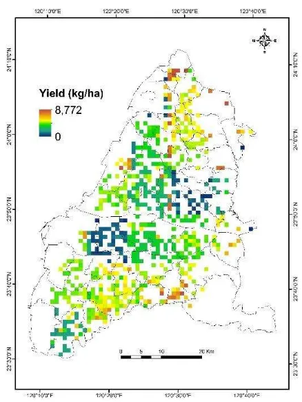
For example, this study used solar radiation derived from ASTER DEM as well as the 8-day MODIS LAI data to generate daily LAI used for the calibration of the simulated results that also included errors due to the resampling process. Thus, further studies of rice yield simulation using parameters derived from remotely sense data could be especially investigated. In general, the spatial distributions of rice yields for the first crop in 2014 indicated that higher yields were concentrated in the north and south parts of the study region, while lower yields were generally observed along the coast and in areas where the terrain was complex (Figure 3).
Table 1. Relative error between the simulated rice yield and the government’s yield statistics for the first crop in 2014.
No. Govt.
Figure 3. Spatial distributions of simulated rice yield for the first crop in 2014.
6. CONCLUSION
The main objective of this study was to develop an approach for rice yield estimation in Taiwan by integrating remotely sensed data into the DSSAT-rice model. The results compared with the government’s rice yield statistics confirmed the validity of our approach for yield estimation in Taiwan, indicating that the RMSE and MAE values obtained for the first crop in 2014 were 11.7% and 9.7%, respectively. This study demonstrates the potential of DSSAT-rice model integrating with remotely sensed data for yield estimation over a large region.
REFERENCES
ADB. 2009. The economics of climate change in Southeast Asia: A regional review. Manila, Philippines: Asian Development Bank.
Bala, S. K., and A. S. Islam. 2009. "Correlation between potato yield and MODIS‐derived vegetation indices." International Journal of Remote Sensing 30 (10):2491-507. doi: 10.1080/01431160802552744.
Chen, Chi-Farn, Nguyen-Thanh Son, Li-Yu Chang, and Cheng-Cru Chen. 2011. "Monitoring of soil moisture boosting to improve image image classification accuracy in rice parcel with decision tree. Paper presented at the ACRS.
Clevers, J. G. P. W., O. W. Vonder, R. E. E. Jongschaap, J. F. Desprats, C. King, L. Prévot, and N. Bruguier. 2002. "Using SPOT data for calibrating a wheat growth model under Mediterranean conditions." Agronomie 22:687-94.
The International Archives of the Photogrammetry, Remote Sensing and Spatial Information Sciences, Volume XLI-B8, 2016 XXIII ISPRS Congress, 12–19 July 2016, Prague, Czech Republic
This contribution has been peer-reviewed.
Dabrowska-Zielinska, K., F. Kogan, A. Ciolkosz, M. Gruszczynska, and W. Kowalik. 2002. "Modelling of crop growth conditions and crop yield in Poland using AVHRR-based indices." International Journal of Remote Sensing 23 (6):1109-23. doi: 10.1080/01431160110070744.
Delécolle, R., S. J. Maas, M. Guérif, and F. Baret. 1992. "Remote sensing and crop production models: present trends." ISPRS Journal of Photogrammetry and Remote
Sensing 47 (2):145-61. doi:
http://dx.doi.org/10.1016/0924-2716(92)90030-D. Dorigo, W. A., R. Zurita-Milla, A. J. W. de Wit, J. Brazile, R.
Singh, and M. E. Schaepman. 2007. "A review on reflective remote sensing and data assimilation techniques for enhanced agroecosystem modeling." International Journal of Applied Earth Observation and Geoinformation 9 (2):165-93. doi:
http://dx.doi.org/10.1016/j.jag.2006.05.003.
Fang, Hongliang, Shunlin Liang, Gerrit Hoogenboom, John Teasdale, and Michel Cavigelli. 2008. "Corn‐yield estimation through assimilation of remotely sensed data into the CSM‐CERES‐Maize model." International Journal of Remote Sensing 29 (10):3011-32. doi: 10.1080/01431160701408386.
FAO. 2011. "Climate change impacts on agriculture in Vietnam." In Strengthening Capacities to Enhance Coordinated and Integrated Disaster Risk Reduction Actions and Adaptation to Climate Change in Agriculture in the Northern Mountain Regions of Viet Nam. Hanoi, Vietnam: FAO.
Furuya, Jun, and Shintaro Kobayashi. 2009. "Impact of global warming on agricultural product markets: stochastic world food model analysis." Sustainability Science 4 (1):71-9. doi: 10.1007/s11625-008-0062-0.
Huang, M.Y., C.J. Huang, and T.T. Fu. 2002. "Cultivation arrangements and the cost efficiency of rice farming in Taiwan."
IPCC. 2007a. Climate Change 2007 - The Physical Science Basis: Working Group I Contribution to the Fourth Assessment Report of the IPCC. Edited by S. Solomon, D. Qin, M. Manning, Z. Chen, M. Marquis, K. B. Averyt, M. Tignor and H. L. Miller: Cambridge University Press.
———. 2007b. "Climate change: AR4 synthesis report." Cambridge University Press.
IRRI. 2006. Bringing Hope, Improving Lives: Strategic Plan, 2007-2015: International Rice Research Institute. Launay, Marie, and Martine Guerif. 2005. "Assimilating remote
sensing data into a crop model to improve predictive performance for spatial applications." Agriculture, Ecosystems & Environment 111 (1–4):321-39. doi:
http://dx.doi.org/10.1016/j.agee.2005.06.005. Masutomi, Yuji, Kiyoshi Takahashi, Hideo Harasawa, and
Yuzuru Matsuoka. 2009. "Impact assessment of climate change on rice production in Asia in comprehensive consideration of process/parameter uncertainty in general circulation models." Agriculture, Ecosystems & Environment 131 (3–
4):281-91. doi:
http://dx.doi.org/10.1016/j.agee.2009.02.004. Matthews, Robin B., C. A. B. International, and Institute
International Rice Research. 1995. Modeling the impact of climate change on rice production in Asia. Wallingford: CAB International in association with the International Rice Research Institute.
Matthews, Robin, and Reiner Wassmann. 2003. "Modelling the impacts of climate change and methane emission
reductions on rice production: a review." European Journal of Agronomy 19 (4):573-98. doi: 10.1016/s1161-0301(03)00005-4.
Mkhabela, M. S., P. Bullock, S. Raj, S. Wang, and Y. Yang. 2011. "Crop yield forecasting on the Canadian Prairies using MODIS NDVI data." Agricultural and Forest Meteorology 151 (3):385-93. doi: 10.1016/j.agrformet.2010.11.012.
Murdiyarso, D. 2000. "Adaptation to Climatic Variability and Change: Asian Perspectives on Agriculture and Food Security." Environmental Monitoring and Assessment 61 (1):123-31. doi: 10.1023/A:1006326404156. Peng, Shaobing, Jianliang Huang, John E. Sheehy, Rebecca C.
Laza, Romeo M. Visperas, Xuhua Zhong, Grace S. Centeno, Gurdev S. Khush, and Kenneth G. Cassman. 2004. "Rice yields decline with higher night temperature from global warming." Proceedings of the National Academy of Sciences of the United States of
America 101 (27):9971-5. doi:
10.1073/pnas.0403720101.
Son, N. T., C. F. Chen, C. R. Chen, L. Y. Chang, and V. Q. Minh. 2012. "Monitoring agricultural drought in the Lower Mekong Basin using MODIS NDVI and land surface temperature data." International Journal of Applied Earth Observation and Geoinformation 18 (0):417-27. doi: http://dx.doi.org/10.1016/j.jag.2012.03.014. Son, N. T., C. F. Chen, C. R. Chen, V. Q. Minh, and N. H. Trung.
2014. "A comparative analysis of multitemporal MODIS EVI and NDVI data for large-scale rice yield estimation." Agricultural and Forest Meteorology 197
(0):52-64. doi:
http://dx.doi.org/10.1016/j.agrformet.2014.06.007. The International Archives of the Photogrammetry, Remote Sensing and Spatial Information Sciences, Volume XLI-B8, 2016
XXIII ISPRS Congress, 12–19 July 2016, Prague, Czech Republic
This contribution has been peer-reviewed.