Open Geospatial Consortium
35 Main Street, Suite 5Wayland, MA 01778 Telephone: +1-508-655-5858
Facsimile: +1-508-655-2237 Editor: Carl Reed Telephone: +1-970-402-0284
The OGC™ Abstract Specification
Topic 0: Abstract Specification Overview
Version 5
Copyright © 2005, Open Geospatial Consortium, Inc.
NOTICE
The information contained in this document is subject to change without notice.
The material in this document details an Open Geospatial Consortium (OGC) specification in accordance with the license and notice set forth on this page. This document does not represent a commitment to implement any portion of this specification in any companies’ products.
While the information in this publication is beleived to be accurate, the Open Geospatial Consortium makes no warranty of any kind with regard to this material including but not limited to the implied warranties of merchantability and fitness for a particular purpose. The Open Geospatial Consortium shall not be liable for errors contained herein or for incidental or consequential damages in connection with the furnishing, performance or use of this material. The information contained in this document is subject to change without notice.
The Open Geospatial Consortium is and shall at all times be the sole entity that may authorize developers, suppliers and sellers of computer software to use certification marks, trademarks, or other special designations to indicate compliance with these materials.
This document contains information which is protected by copyright. All Rights Reserved. Except as otherwise provided herein, no part of this work may be reproduced or used in any form or by any means (graphic, electronic, or mechanical including photocopying, recording, taping, or information storage and retrieval systems) without the permission of the copyright owner. All copies of this document must include the copyright and other information contained on this page.
Revision History
Date Description
15 March 1999 Carried over previous version 98-100r1 and updated for 1999; add new Section 3.2, per change proposal 99-010 (w/ friendly amendments), adopted February 9, 1999; update relationships of Topic Volumes to WGs and SIGs in Section 2.5; update for new Topic Volumes 10, 15 and 16; updated description of the Abstract Specification, Section 2.2 and changed use of terms “Abstract Specification” and “Abstract Model” elsewhere to be consistent; added Sections Error!
Reference source not found., Error! Reference source not found. & Error! Reference source not found. from change proposal 98-072, approved February 9, 1999;
Table of Contents
1.
Introduction ...1
1.1.
The Open Geospatial Consortium ... 1
1.1.1. Overview... 1
1.1.2. Vision and Mission ... 1
1.1.3. Specifications ... 1
1.2.
The Open Geospatial Consortium Process ... 1
1.2.1. The Consensus Process... 1
1.2.2. The Open Geospatial Consortium Reference Model (ORM) ... 1
2.
The Abstract Specification ...3
2.1.
Background ... 3
2.1.1. The OGC Abstract Specification Topic Volumes... 3
2.2.
Purpose of the Abstract Specification... 3
2.3.
Relationship to the work of ISO TC 211 ... 3
2.4.
Topic Volumes ... 4
2.5.
Topics and Their Proponents... 4
2.6.
Relationships Between the Topic Volumes ... 5
2.6.1. Central Themes: Sharing Information and Providing Services... 5
2.6.2. Providing Geospatial Services... 5
2.6.3. Sharing Geospatial Information ... 5
2.6.4. Prerequisites for Sharing Geospatial Information ... 5
2.6.5. Miscellaneous Topics... 5
2.7.
References for Section 2 ... 6
3.
Guidelines and Conventions ...7
3.1.
The Structure of Individual Topic Volumes... 7
3.1.1. Introduction to the Topic ... 7
3.1.2. The Abstract Model of the Topic... 7
3.1.3. Future Work... 7
3.1.4. Glossary and Acronyms Supporting the Topic ... 7
3.1.5. Well Known Structures Supporting the Topic... 7
3.2.
The Use of Object Modeling Notation ... 8
3.3.
References... 8
1. Introduction
1.1. The Open Geospatial Consortium
1.1.1. Overview
The Open Geospatial Consortium (OGC) is a not-for-profit organization dedicated to open systems geoprocessing. For more information on the OGC and its mission and activities see our World Wide Web site at <http://www.opengeospatial.org>. In this section we very briefly introduce the vision of the OGC and to its major technical body, the OGC Technical Committee.
1.1.2. Vision and Mission
A world in which everyone benefits from geospatial information and services made available across any network, application, or platform. The Mission of the OGC is to lead the global development, promotion and harmonization of open standards and architectures that enable the integration of geospatial data and services into user applications and advance the formation of related market opportunities.
Specifications
The OGC Standards Development Process [1] creates two types of standards products: Abstract and Implementation specifications. The purpose of the Abstract Specification is to create and document a conceptual model sufficient enough to allow for the creation of Implementation Specifications. Implementation Specifications are unambiguous technology platform specifications for implementation of industry-standard, software application programming interfaces.
1.2. The Open Geospatial Consortium Process
1.2.1. The Consensus Process
The Open Geospatial Consortium uses a process of consensus gathering among its membership in order to define, test, edit, and approve standards for interfaces and encodings that enable
interoperability of geospatial content, services, and applications..
Through the activities of Revision Working Groups and Working Groups, members of the Consortium develop Abstract Specifications. These documents are brought before the Technical Committee for presentation, discussion, and approval.
When individual topics of the Abstract Specification are sufficiently mature, the OGC community can use that topic as a foundation for related interface and encoding specifications.. The OGC Request for Comment (RFC) standard process by which new candidate specifications are introduced to the OGC membership. Upon consensus acceptance by the OGC membership, the Implementation Specifications become a part of the OGC suite of specifications known as the OGC Technology Baseline. Software that is nominated by members is checked for conformance to the Implementation Specification, and if found conforming, is distinguished by an OGC trademark.
1.2.2. For detailed information on the OGC Standards Development Process refer to OGC
documents [1] and[2]. The Open Geospatial Consortium Reference Model (ORM)
The OGC consensus process has resulted in the adoption of numerous Abstract Specification topic volumes (described below) and numerous implementation specifications. Further, through the work of the membership, much of the ongoing effort of the OGC is harmonized with the work of other standards organizations, such as ISO, OASIS, and the W3C. In order to capture the essence of the work of the OGC in a structured manner, the OGC has developed and continues to maintain the OGC Reference Model (ORM)
The ORM supercedes the technology and architecture sections of the original 1996 OpenGIS Guide.The OGC Reference Model (ORM) provides an architecture framework and reference model that documents the current OGC Technical Baseline. It also documents the current thinking regarding the technology and interoperability for on-going work in the OGC.
The ORM has the following purposes:
! To provide the basis – or common semantic - for communicating, coordinating and understanding the work of the OGC.
! Describes the OGC architecture framework through a series of non-overlapping viewpoints: including existing and future elements.
! To promote the development of domain-specific interoperability architectures by providing examples.
The ORM is based on the Reference Model for Open Distributed Processing (RM-ODP, ISO/IEC 10746), a widely used international standard for architecting open, distributed processing systems. The RM-ODP provides an overall conceptual framework for building distributed systems in an incremental manner. The ORM provides an overall conceptual framework for building geoprocessing into distributed systems in an incremental manner.
References for Section 1
[1] Open Geospatial Consortium, 2005. OGC Technical Committee Policies and Procedures, Wayland, Massachusetts. Available at http://www.opengeospatial.org/docs/pnp.pdf .
[2] OGC 2004, The Tao of the OGC – A Guide for New Members.
2. The Abstract Specification
2.1. Background
2.1.1. The OGC Abstract Specification Topic Volumes
The Open Geospatial Consortium maintains the OGC Abstract Specification as a number of Topic Volumes. This document (Topic 0) is an overview of the OpenGIS™ Abstract Specification. Each Topic Volume addresses a specific set of abstract models, such as for metadata or geometry, required as a foundation unit upon which to build OGC interoperability standards. The complete set of Topic Volumes collectively form the OpenGIS™ Abstract Specification [2].
2.2. Purpose of the Abstract Specification
The purpose of the Abstract Specification is to create and document a conceptual model sufficient enough to allow for the creation of Implementation Specifications.
The purpose of the Abstract Specification is:
•
To relate software and system design to real world situations.•
To capture and precisely state requirements and domain knowledge so that all stakeholders may understand and agree on them.•
To think about the design of the system.•
To capture design decisions in a mutable form separate from the requirements.•
To generate usable work products (such as prototypes and proof of concept implementations).•
To organize, find, filter, retrieve, examine and edit information about large systems.•
To explore multiple solutions economically.•
To master complexity.The Abstract Specification, and specifically the Abstract Model, is used in all these capacities. Additionally, it provides an implementation neutral, but technically complete “language” to discuss issues of interoperability.
2.3. Relationship to the work of ISO TC 211
ISO TC 211 is a de-jure standards setting organization whose focus is in the field of digital geographic information. Their work aims to establish a structured set of standards for information concerning objects or phenomena that are directly or indirectly associated with a location relative to the Earth. These standards may specify, for geographic information, methods, tools and services for data management (including definition and description), acquiring, processing, analyzing, accessing, presenting and transferring such data in digital/electronic form between different users, systems and locations. The work must provide links to appropriate standards for information technology and data where possible, and provide a framework for the development of sector-specific applications using geographic data.
In the fall of 1998, OGC and ISO/TC211 signed an agreement establishing a Class A Liaison relationship that allows both organizations to take full advantage of the contributions of the other. Since then the two organizations have collaborated in a number of areas. These include
incorporating ISO TC 211 documents as part of the OGC Abstract Specification as well as OGC submitting OGC Implementation Specifications to ISO for consideration for adoption as International Standards.
2.4. Topic Volumes
There are currently 17 “books” in the OGC Abstract Specification (including this one, Topic 0). Each is called a “Topic,” and given a descriptive name. The Abstract Specification refers to the collection of Topic Volume documents referenced by [2].
The Abstract Specification is broken into Topics in order to assist parallel developments of different topics by different Working Groups of the OGC membership. Figure 1 shows some dependency relationships between topics.
Topic 9
Figure 1: Abstract Specification Topic Dependencies
The Abstract Specification is organized into separate topic volumes in order to manage the complexity of the subject matter and to assist parallel development of work items by different Working Groups of the OGC Technical Committee. The topics are, in reality, dependent upon one another each one begging to be written first. Each topic must be read in the context of the entire Abstract Specification.
The topic volumes are not all written at the same level of detail. Some are mature and some are less mature. Many have been harmonized with the work of ISO TC-211. The level of maturity of a topic reflects the level of understanding and discussion occurring within the Technical Committee. Refer to the OGC Technical Committee Policies and Procedures for more information on the OGC standards development process.
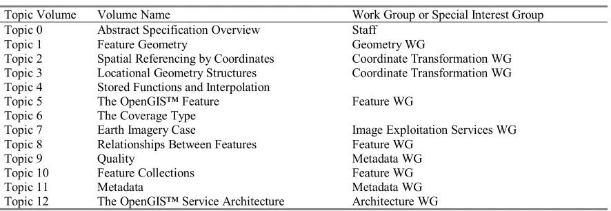
2.5. Topics and Their Proponents
The 17 Topics and the Technical Committee Work Groups (WGs) primarily responsible for their maintenance are:
Topic Volume Volume Name Work Group or Special Interest Group
Topic 0 Abstract Specification Overview Staff
Topic 13 Catalog Services Catalog WG Topic 14 Semantics and Information Communities ICS WG
Topic 15 Image Exploitation Services Image Exploitation Services WG
Topic 16 Image Coordinate Transformation Services Image Exploitation Services WG and Coordinate Transformation WG
Additional Domain Topic volumes are as follows:
Topic Volume Topic Name Work Group or Special Interest Group
Domain Topic Domain 1 - Telecommunications Domain
Additional topics may be added as the scope of the OGC widens, at the consensus of the OGC membership.
2.6. Relationships Between the Topic Volumes
2.6.1. Central Themes: Sharing Information and Providing Services
The OGC has two central standards development themes: Sharing Geospatial Information, and Providing Geospatial Services.
Topics 12 and 13 are concerned with providing geospatial services. The remainder of the topic volumes are focused on sharing geospatial information.
2.6.2. Providing Geospatial Services
Topic 12 specifies a comprehensive set of geospatial services. Topics 13, 15 and 16 describe, in greater detail, specific categories of geospatial services.
A great many additional services are foreseen.
2.6.3. Sharing Geospatial Information
Topics 5, 6, and 7 are centered on sharing geospatial information. These Topics are the
OpenGIS™ Feature, the Coverage Type, and Earth Imagery. The Coverage is a special case of an OpenGIS™ Feature, and an Earth Image is a special case of a Coverage. Each of these Topics (5,6 and 7) is fundamentally concerned with the handling and exposing of Geospatial information, whether it is modeled using Features With Geometry, Coverages, or with the Imagery information type.
2.6.4. Prerequisites for Sharing Geospatial Information
Topics 1, 2, 3, 8, and 11 directly support Topics 5, 6, and 7. Topic 1 provides the Geometry structures for Features With Geometry. Topics 2 and 3 deal with the same subject (geolocation), but in two different technology domains. The general subject is relating model coordinates to Earth coordinates. Topic 2 provides the Spatial Reference Systems by which features are related to positions on the Earth in the discipline of Geodesy. Topic 3 adds tools for providing geospatial referencing to image coordinates, raster coordinates, and indirect referencing systems that are not found in Geodesy texts. Topic 8 provides for the modeling and exposure of relationships between features. Topic 11 provides for the modeling and query of metadata. Each of these Topics is essential before any geospatial information may be shared.
Topic 4, on Stored Functions, is necessary to support Topic 6, Coverages. Most Coverages depend on two stored functions. The functions map respectively “to” and “from” a mathematical
coordinate space called the Coverage Extent, or a Spatial Domain. The first function, the Coverage Generation Function, maps from Earth coordinates to Coverage Extent Coordinates, and provides geolocation. The second, the Schema Mapping, maps from the Coverage Extent to some range of values. In general, both functions might be stored.
2.6.5. Miscellaneous Topics
The remainder of the Topics fall into the “Miscellaneous” category. These are: Topic 10 Transfer Technology
Topic 14 Semantics and Information Communities
All three of these Topics have strong information theoretic content that is not strongly tied to geospatial issues. Perhaps, in the long run, this means that these Topics will be endowed with interoperable interfaces by authorities other than the OGC. In the immediate future, however, these Topics must be enabled with interoperating technology by OGC, as they are necessary for the understanding of and access to geospatial information.
2.7. References for Section 2
[1] Open GIS Consortium, 1999. The OpenGIS™ Abstract Specification, are available at the OGC Web Site using the Find Documents widget. <http://www.opengeospatial.org>.
[2] Open GIS Consortium, 2005. OGC Technical Committee Policies and Procedures, Wayland, Massachusetts. Available at http://www.opengeospatial.org/docs/pnp.pdf .
[3] Cook, Steve, and John Daniels, Designing Objects Systems: Object-Oriented Modeling with Syntropy, Prentice Hall, New York, 1994, xx + 389 pp.
3. Guidelines and Conventions
3.1. The Structure of Individual Topic Volumes
Each Topic volume ordinarily contains six sections: Section 1 Introduction to the Topic
Section 2 The Abstract Model of the Topic Section 3 Future Work
Appendix A Glossary and Acronyms supporting the Topic Appendix B Well Known Structures supporting the Topic
Each section may conclude with a “References” subsection in order to simplify references to other Topics, and to other sources of technology.
3.1.1. Introduction to the Topic
Each Topic document should have an Introduction to the subject. The Introduction has a brief description of the purpose and scope of the Abstract Specification. The Introduction also states the subject and scope of the topic volume. The Introduction should also provide a history and status of work on the topic.
The Introduction of each Topic provides space to describe how each Topic is related to other Topics and to other standards. The Introduction should also reference the central documents of the Consortium and, at a minimum, the Abstract Specification Overview [1].
3.1.2. The Abstract Model of the Topic
Section 3, the Abstract Model, is the heart of each Topic document. Structured graphical or lexical languages for the expression of the conceptual schema are encouraged.
Typically, the Abstract Model identifies the classes and subclasses of interest, identifies and describes their relationships, and abstractly specifies the interfaces that are to be implemented in software.
At the most fundamental layer of information sharing, well known structures (WKS) are necessary. To make the WKS easily available to system developers, they are not ordinarily placed in the Abstract Model, but rather in an Appendix of the appropriate Topic volume.
The Abstract Model section of each Topic should provide references to foundation information for any advanced technology introduced.
3.1.3. Future Work
The specification and maintenance of OGC standards will never be completely finished. This is because Geospatial Information, like other information, is constantly growing, changing, and being integrated into new environments. Moreover, the Geospatial marketplace is expected to be a dynamic source of new requirements. Where it is possible, each Topic should identify the most important “next” developments that should be undertaken by the Working Group responsible for the Topic. This list of needs and future requirements constitutes the Future Work section.
3.1.4. Glossary and Acronyms Supporting the Topic
Terminology and acronyms specific to the Topic Volume should be defined in an Appendix.
3.1.5. Well Known Structures Supporting the Topic
Well Known Structures are to be expressed in Interface Definition Language (IDL), if possible, and placed in an Appendix of the appropriate Topic volume.
3.2. The Use of Object Modeling Notation
The Unified Modeling Language (UML) shall be used as the notation for all object oriented models included in OGC Abstract Specification and Implementation Specification documents. Specifically UML provides the notation for:
Use-Case Models Class Diagrams Object Diagrams State Diagrams Sequence Diagrams Collaboration Diagrams Activity Diagrams Component Diagrams Deployment Diagrams
UML is defined in a series of documents from the Object Management Group, specifically [2], [3], [4], [5], [6], [7] and [8].
The reader is referred to the appropriate industry available documents for detailed discussions and tutorials on UML.
Figure 3-1: Basic Language Types
3.3. References
[1] Open GIS Consortium, 2005. Topic 0, Abstract Specification Overview, Wayland, Massachusetts. Available at www.opengeospatial.org ..
[2] OMG Document ad/98-08-03, UML Summary version 1.1, 1 September 1997 [3] OMG Document ad/98-08-04, UML Semantics version 1.1, 1 September 1997 [4] OMG Document ad/98-08-05, UML Notation Guide version 1.1, 1 September 1997
[5] OMG Document ad/98-08-08, Object Constraint Language Specification version 1.1, 1 September 1997
[6] OMG Document ad/97-08-09, OA&D CORBA facility Interface Definition version 1.1, 1 September 1997
[7] OMG Document ad/98-08-07, UML Extension for Business Modeling version 1.1, 1 September 1997