VOL. 3, NO. 1, pp. 34 – 42, January, 2013
The Technique of Agroforestry at Communal Forest Areas in Pejarakan
Village, District of Gerokgak, Regency of Buleleng, Bali Province
I Putu Gede Ardhana1*, Sunardi2
1
Department of Biology, Faculty of Sciences, Udayana University, Denpasar, Indonesia 2
Branch Office for Forest Inventory and Land Classification Unit Denpasar, Indonesia
ABSTRACT
Since 2003, the technique of agroforestry with alley cropping systems has been implemented at the forest areas in Pejarakan Village, District Gerokgak, Regency of Buleleng, Bali Province. These activities are expected to support the progress of welfare for farmers, though they have been neglected to preserve forest around village. The result of the research shows that the result of the activities do not fulfill its first expectation. The analysis on the compositions and structures of vegetations in this research shows that the dominant type of species which was mainly cultivated had the character of Importance Value Index, while the balance of species among diversity index was still low at all of the communal forest areas and even at the slope sides. The composition and the structure of species were still few, and the vegetation itself was disturbed by people. With regard to illegal loggings, cuttings top branches or twigs often occuredr, and these activities brought about obstacle growth of trees in communal forest areas. It is concluded that the technique of agroforestry at the communal forest areas has few compositions of species and structure of vegetations, so the diversity of species becomes very poor and unstable, either for plants in forestry or for agricultural crops. The researcher could not determine what species of vegetations is superior at this area. Therefore, it necessarily needs some more time for intensive observations and research at this communal forest areas.
Keywords: agroforestry technique, communal forest areas, composition and structure of vegetation, forest area, species diversity
INTRODUCTION
The area of dry land in Indonesia reaches about 80 million hectares from the total territory of Indonesia [1]. In the country, the island of Bali has about 218,119 ha of dry land which is concentrated in the northern and eastern areas of the island [2]. The study about dry land was located in the communal forest (HKM) areas of Pejarakan Village, District of Gerokgak, Regency of Buleleng, Bali Province. The annual precipitation is 1400-1700 mm that falls mainly from December to March [3]. According to the map of soil types in Bali, the site belonges to chocolate and latosol soil type which are mainly made up of volcanic ash.
Within the government Regulation of the Minister of Forestry, number: P.01/Menhut-II/2004, Article 3, it is stated that in order to
*
Corresponding author: I Putu Gede Ardhana Department of Biology, Faculty of Sciences, Udayana University, Denpasar, Indonesia
Email: [email protected]
realize sustainable development for forestry and to improve the welfare of local communities, it is necessary to empower the local communities with community-based forest management system which is called Communal Forest (HKM). HKM is one of the systems that involves the participation of other parties who are permitted to take advantage from forest production in anywhere within the forest areas.
In such a territory, each Head of the Family (or, Kepala Keluarga (KK)) from farmers' group have been given each arable land of 0.5 ha. In this location of study, 100 families have cultivated about 50 ha of the area. The farmers group carry out the land management activities by employing the alley cropping system. Within this system, they obtain the crop of trees and the seasonal agricultural crops. The trees are planted in path lines which are 6 meters wide. These paths form a space between forest plants and seasonal agriculture crops.
At the time of the preliminary study, the space (interface) becomes narrower because the canopy trees make shade trees with plant age 7 (seven) years. Furthermore, the utilization and process of soils at interface of land space begin to decrease and, thus, abandon the cultivation of seasonal agricultural crops which has been rarely performed. The various types of vegetations have been covered by the community plants species as a habitat or niche that forms the dispersion pattern, the pattern of density and the pattern of mastership degrees of each type of vegetation in this area.
The locations of the study site have different slope conditions, namely, the flat site (0-8%), the ramp site (9-15%), a-bit steeping site (16-25%) and steep site (26-45%). These locations represent the different types of vegetation. This difference in vegetational type brings the difference in distributional pattern for each type, so we can calculate the form of relative frequency, the relative density, the relative dominance and the pattern of importance Value Index. Each type makes three summations and it shows the pattern of Importance Value Index (IVI), or "index of Important value". This value is usually used to determine the Index Diversity (ID) for vegetational compositions. The absolute association determines the role of each vegetational type in relation to environmental factors. Each plant species with regard to environmental factors can be seen in the process of soil formation. It is to say that the land becomes the main factors for material, climate, relief or landscape, time and organisms.
Vegetational compositions and the structures of the alley cropping system usually mean the probe properties of occupied habitat [4]. Therefore, in the activities of HKM location, they would be determined by conducting research Analysis of Vegetation in this site. The results of vegetation analysis are expected to be used for materials and advice in forest management in the next period which aims to
improve the welfare of the surrounding community and within the forest area.
The purpose of this study is to determine the compositions and the structures of vegetation in the cultivational area of alley cropping, the degree important value index of each type vegetation (IVI), diversity index and the balance of species diversity (ID) in HKM activity after a seven-year-old forest stands.
MATERIALS AND METHODS
The scheme of research
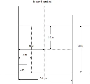
This research employed the plot method in sampling technique, that is, we determined the square-shaped plot for observations (Fig. 1). We brought several plot in the right and left side along the main line and used main lines (transects) as the path for observations. There were four transects, the distance between each was 100 meters. These transects cut off the path and were divided into four classes in the slope (KL). Each KL along each transects formed square plots for observation. We, eventually, had 16 square plots for observations and the size of each plot was 2 m x 2 m for collecting data of seedlings, 5 m x 5 m for collecting data of saplings, 10 m x 10 m for collecting data of poles and 20 m x 20 m for collecting data of trees.
Figure 1. The plot for observation for growth stage of plants
Note : 20 m x 20 m - for collecting data of trees 10 m x 10 m - for collecting data of poles 5 m x 5 m - for collecting data of saplings 2 m x 2 m - for collecting data of seedlings
We brought basic usages of this KL from the map for classifications of slopes in forest land enacted by the General Director of Forest Inventory and Forest Land Usage [5]. According to this map, these plots were classified into (Figure 2):
b. KL 2 ranged between 9-15% for the criteria ramp
c. KL 3 ranged between 16-25% for the criteria a bit steep
d. KL 4 ranged between 26-45% for the criteria steep
Figure 2. The planning plots for each point in different kl observation
In order to analyse the compositions and structures of vegetation, we used the plot the size of which was 20 m x 20 m for the growth rate in various the pole, 5 m x 5 m for sampling rate, 2 m x 2 m for seedlings in each level of trees. We brought samples and collected data from all vegetation which existed in these plots, and these ranged from seedlings or undergrowth plants, saplings poles to trees. The criteria to determine the growth stage of these vegetations are:
• The level of seedlings and undergrowth plants with diameter ≤ 2 cm and with height ≤ 1.5 m
• Level of saplings with diameter > 2 cm to < 5 cm with height > 1.5 m
• Level of poles with diameter ≥ 5 cm to <10 cm
• Level of trees with diameter ≥ 10 cm
The Research Site
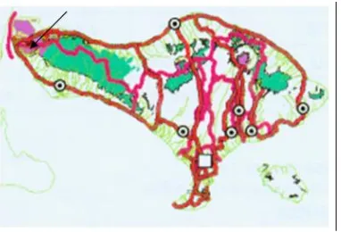
We surveyed this study site at Pejarakan Village, Gerokgak District, Regency of Buleleng, BaliProvince. In this village, there was a land management for alley of cropping system called HKM in 50 ha where farmers group ‘Wanna Sources Makmur’ managed the system since 2000. The research was conducted from March to May 2007 when the cultivation of seasonal agricultural crops began to be stopped or left untreated by the farmers group. At that time of the study, the forest stands were seven years old. The location of the research can be seen in Figure 3.
Figure 3. Research site
The Analysis of Vegetational Composition and Structures
a. Density (Density) = Σ all individuals of each
species / total area of plot
b. Relative density (RD) = (density value of each species / total density of all species) x 100%
c. Frequency = Σ found types in the plots
samples in each plots
d. Relative frequency (FR) = (frequency value of type / value of the frequency of all species) x 100%
e. Dominance (abundance) = Σ a type of basal
area / total area of plot
f. Relative dominance (DR) = (dominance of a species / total dominance of all species) x 100%
g. Important Value Index (IVI) = degree of mastership of each type of vegetation
(6)
(7) h. Species diversity index (I) or
(8)
I (0.00 to 3.00)
Pi
Pi log Pi
₌
₌
₌
Index of diversity (diversity index) I <1: low diversity
1 ≥ I < 2: medium diversity 2 ≥ I < 3: high diversity
Number of individual species (ni) divided by the number of individuals in the sample plots(N) or (ni / N) Log of price
RESULTS AND DISCUSSION
The Vegetational Compositions and Structures
The result of the analysis of vegetational compositions and vegetational structures in the stage of plant growth forest are as follows. The level of saplings, the poles and the trees consisted of 5 (five) forest plant species which spread across multiple slope classes (Table 1).
IVI = RD + FR + DR
IVI = RD + FR
Table 1. The vegetational compositions and structures of forest plants at stage of saplings, poles, and trees cult ivatied on the some classes in Pejarakan village
Slope Classes
Vegetation Compotition
(Species) Local Name
Vegetation Structure (Stage)
Saplings Poles Trees
KL 1 (0-8%) (flat)
Azadiractha indica Juss Leucaena glauca Benth Swietenia macrophylla King Albizza falcataria L.
Intaran
Azadiractha indica Juss Leucaena glauca Benth Swietenia macrophylla King Dalbergia latifolia Roxb.
Intaran
Azadiractha indica Juss Leucaena glauca Benth Swietenia macrophylla King Dalbergia latifolia Roxb.
Intaran
Azadiractha indica Juss Leucaena glauca Benth Swietenia macrophylla King Dalbergia latifolia Roxb.
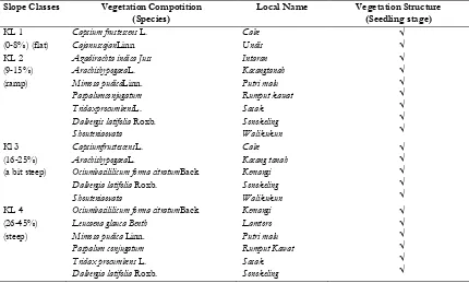
Intaran vegetational compositions and structures of plantings at the stage of the seedlings cultivation,
we could found 11 (eleven) agricultural plant species which spread across multiple slope classes (Table 2).
Table 2. The vegetational composition and structure of forest stand at the stage of seedling cultivation (seedlings) on the slopes in the of some classes Pejarakan village
Slope Classes Vegetation Compotition
(Species)
Local Name Vegetation Structure
(Seedling stage) KL 1
(0-8%) (flat)
Capsium frustescens L. CajanuscajanLinn
Azadirachta indica Juss ArachishypogaeaL. Mimosa pudicaLinn. Paspalumconjugatum TridaxprocumbensL. Dalbergis latifolia Roxb. Shouteniaovata ArachishypogaeaL.
Ociumbasililicum forma citratumBack Dalbergia latifolia Roxb.
Shouteniaovata
Ociumbasililicum forma citratumBack Leucaena glauca Benth
Mimosa pudica Linn. Paspalum conjugatum Tridax procumbens L. Dalbergia latifolia Roxb.
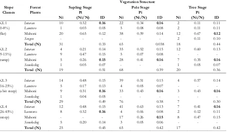
Table 3. Relative density (RD), relative frequency (FR), relative dominance (DR), importance value index (IVI) levels based on forest plant saplings, poles, and trees on slopes in the village of some classes Pejarakan
Slope Classes
Forest Plants
Vegetation Structure
Sapling Stage Pole Stage Tree Stage
RD in Forest Stand Forest Plants
The highest diversity index (ID) which put in trees on slopes at saplings and poles stage was occupied by Intaran, that is 0.16 and 0.16, respectively; whereas at the level of tree stage, Mahogany was the highest (0.12). Mahogany also showed the highest ID value at the third level of
the growth stage for saplings, poles and trees, that is 0.15, 0.16 and 0.16, respectively, at KL 2 and KL 3. If put in a row, these variables valued 0.16, 0, 16 and 0.16. In KL 4, Lamtoro showed the highest ID (0.16) at saplings, Mahogany the highest ID value (0.15) at the poles, and Intaran the highest at trees level (0.16) (Table 4).
Table 4. The type and level of diversity index (index of diversity) based on forest plants id saplings, poles, and trees at slopes classes at pejarakan village
Slope Classes
Forest Plants
Vegetation Structure
Sapling Stage Pole Stage Tree Stage
Agricultural Crops and Undergrowth Species
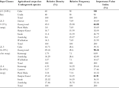
Table 5 indicates that cabe had the highest IVI (110%) at the class of flat slope (KL 1), while Kacang tanah had the highest IVI, that is 66.08%
and 98.24% at grade slope ramp (KL 2) and somewhat a-bit steep (KL 3), respectively. Rumput kawat had the highest IVI (61.91%) at the class of steep slopes (KL 4).
Table 5. Relative density (RD), relative frequency (FR), importance value index (IVI) of agriculture crops and plant cultivation several classes at aisle village slope pejarakan
Slope Classes Agricultural crops dan Undergrowth species
Relative Density (%)
Relative Frequency (%)
The Diversity Index or the Index of Diversity (ID) of seasonal crops and undergrowth plants had all worth <1.0. The ID value of seasonal agricultural crops and undergrowth plants was the highest (0.16) at KL 1 in which the Undis occupied this position, while KL 2 was occupied
by Rumput Kawat (0.60). Meanwhile, in KL 3,
Slope classes Agricultural crops and undergrowth species
Slope classes Agricultural crops and undergrowth species
Total Species in 4 Sample Plots
(Ni)
Pi = (Ni/N)
Diversity Index (ID)
KL 4 (26-45%) (steep)
Kemangi Lamtoro Putri Malu Rumput Kawat Sasak Sonokeling
4 2 2 30 14 11
0.06 0.03 0.03 0.48 0.22 0.18
0.08 0.05 0.05 0.15 0.14 0.13
Total 63 0.60
We could see that the composition and structure of plant vegetation in the forest stand has some variations for the plant species, growth stage of saplings, poles and trees on each classes of slopes, except on a bit steep slope class (KL 3) and steep (KL 4). Only five species of forest plants were found in the compositions of forest plant, namely, Intaran, Lamtoro, Mahogany, Sonokeling and Sengon. These plants were distributed equally in each class of slopes (KL 1, Kl 2, KL 3 and KL 4), and were given estimations (DR), and Important Value Index (IVI). Intaran and Lamtoro grew wild, while Mahogany, Sonokeling and Sengon were cultivated as main crops in the line.
At the flat class of slope (KL 1), the composition of plant species were dominated by Mahogany, while at the slope classes (KL 2), Lamtoro became the most common species. At KL 3 and KL 4, the compositions were dominated by Intaran. In each class of slope, the hightof INP defined activities in research areas, and was obtained from the sum of variable value (RD), (FR), and (DR) of each type. INP was the sum of (KR), (FR), and (DR) researching types [6] and the high INP was the type of power (dominant) (Soegianto, 1994 in [8]).
At flat slope class (KL 1), Mahogany had the highest value of RD, FR, and DR in the level of saplings, poles and trees. Meanwhile, the value of IVI indicated the highest evaluations, that is, 177.3%, 161.0% and 162, 4% against other forest plant species. The Sengon saplings and even small trees were found in KL 1, and these were only mature trees with IVI = 52.8%. In slope class (KL 2), Intaran had the highest value at the level of poles (144.6) and trees (166.4%), while Lamtoro at the level of saplings had the highest IVI (127.6%). Only a small quantity of Sonokeling was found, even it could not be found at slope class (KL 2). Such variations may be caused by the presence of pruning branches and Lamtoro and Sonokeling were used for animal feed. This situation reduced the number of these plants.
At rather a-bit slope class (KL 3), Intaran dominated as forest plants and had the highest IVI value among other species at the level of
saplings (137.05%), of the poles (148.0%) and of trees (161.6%). At this slope class (KL 3), Lamtoro and Sonokeling were not found at the level of trees since they might have been cut down illegally. At steep slope class (KL 4), Intaran dominated the forest stands but only at the level of saplings (132.7%) and poles (164.5%), while Mahogany had the highest IVI (133.1 %). At the level of trees, Lamtoro could only be found in small amounts (IVI = 41.8%), while Sonokeling was not found at all at this level in KL 4 and KL 3. The pruning branches and illegal logging were suspected to happen at KL 4 evident from some leaves which remained in Lamtoro and Sonokeling.
At each slope class, the difference of dominancy for forest plant species was strongly caused by the Mahogany and Sengon planting activities which were carried out from 2000 in these areas. Thus, Mahogany became the major species for reforestasion and planting activities at the flat slope class (KL 1). In 2003 the exchange of species had been carried out at each slope class. As a result of orientation for production forest area in Pejarakan Village, the forest plant species were converted into Intaran, Mahogany, and Sonokeling [9].
Planting also gradually led to differences in growth rates of different forest plants, leading to the finding of the structure of vegetation at the level of saplings, poles and trees. In addition, some species might have been dead or cut down illegally, so the number of individuals and species were diminished.
In each class slope, the communal forests showed unstable ID value in which the value was less than one (<1). In these study sites, it referred to the fact that the species vegetative compositions were less found. That also meant that they were in a stage in which the pioneer species such as shrubs and bush were yet dominant because continua ring cares and burning leaves have created these conditions.
Consequently, the crops of Sonokeling became growing slowly. The pruning of branches or twigs greatly affected the growth of a plant species because it is these actions numbers of leaves that had the role to relate the process of photosynthesis and respiration.
The DR values were relatively reflected by the diameters of basal area of trees which had an effect on the crown density of the forest plants. The stages of planting were considered similar when domination (DR) > 70% was evaluated, and as sufficient the value of DR 40%-70% was evaluated as rare [8]. At the study sites, at the level of saplings, poles, and trees, the dominant species on each class of canopy density slope was quite rare until intermediately tolerant (40%-51.3%). Such conditions sunlight is still more likely to get into the forest stage that could be utilized by crops.
As for the crops which were planted in the alleys, the dominant crops which had high (RD=60% at KL 1) were Cabe and Kacang tanah (RD = 69.64% at KL 3), while Lamtoro, Putri Malu, Sp. Undis and Walikukun were less dominant at each class of slope. Among the dominant species, the high IVI was also considerably supported by the presence of vegetative compositions such as RD, FR, DR of each species [6; Soegianto, 1994 in [8]]. From result of the research, at KL 1 Cabe’s IVI = 110%; at KL 2 and KL 3 Kacang tanah’s IVI = 66.8% and 98.24%; and at KL 4 RumputKawat’s IVI = 61.91%. At flat slope class (KL 1) Undis reached relatively high density (RD = 40%) with IVI = 61.91%, lower than Cabe, but this species was not found at ramp, a-bit steep and steep slope classes (KL 2, KL 3 and KL 4). These conditions were probably caused by the presence of the surface layer of soil erosion at steep slopes which take places every year in the rainy season, making the soil layer depleting, thin and unproductive for Undis planted.
As for crops which were planted in the alleys, the conditions at KL 1, KL 2, KL 3 and KL 4 showed that the community was not yet stable, that is the ID was only less than one (<1). However, at KL 1, Undis had the highest value, while at KL 2 and KL 4 Rumput Kawat had the highest value. At KL 3, Kacang tanah was the highest. Rumput Kawat was one kind of grass which farmers planted for the purpose of animal feeds. The low value of ID was affected by low new pioneer species which could live in cultivative fields due to tillage treatments that were continually performed in every planting season.
At the production forest areas in Pejarakan village, communal forest members may cultivate plant crops within 3-5 years and carry out the reforestation on each slope class. Within these 3-5 years, communal forest members must participate in maintaining these forest conditions, and they are permitted to get crops as fodder, firewood and for other personal use around the areas. This condition was associated with the government effort to involve communal forest to preserve and maintain forest sustainability by protecting forests from illegal actions. The productive forests formed the kind of artificial forest which was decided by human inventively [10].
Undisturbed forest ecosystem plays an important role for soil and water conservations. Humans beings need to preserve the forest to help protect preserve and prevent damages of forest ecosystem as well as to participate in the efforts of the government in reforestation of degraded lands. The production forest area of Pejarakan Villages in Regency of Buleleng has long experienced on degradations with natural conditions and local disturbances such as loggings and forest encroachments. The degradations occurred from 1997 to 1999 on the era of reform and have been continuing until today [9].
Careful management for production forests should be carried out by implementing agroforestry techniques which emphasize on the maintenance of forest plants in order to materialize the productive forest conditions, so be improve are safe able to the benefits and the welfares of local communities through independent, professional and sustainable management of the business. In addition to wood, the forest production will offer other products such as firewood, animal feed or food, medicinal plants, and utilities crops cultivation which the interface on the aisle. If the community is about to be involved in the cultivation, special management activities should be taken into account, such as preparation for planting seasonal crops started from the rainy season on October by doing the cleaning of weeds every July and tillage conducted in August.
3) and steep (KL 4), which aims to improve soil and water conservation. At the classified areas of Pejarakan village, the vegetation of forest plants was not popular indicated by the rank from rear to intermediate tolerant (40%-51.3%). This condition makes the sunlight could get into forest floors to help the productions of cultivated crops at study sites. We need to try planting another crop species at flat slope class (KL 1) and ramp class (KL 2) in accordance with these tolerance of shade by canopy trees to which provide areas at Pejarakan Village, Gerokgak District, Regency of Buleleng can run continuously.
CONCLUSION
Based on the results and discussion in the previous sections, some conclusions can be made as follows:
1. As for the species compositions and structure at
HKM areas, there were only 5 (five) species of forest plants and 11 (eleven) plant species, including seasonal crops under agricultural cultivation. The vegetative structures on level of saplings, poles and trees were found in forest
plants and seasonal agricultural crops;
undergrowth plants were found in plant seedlings level.
2. The patterns which represent each vegetative
types from the degree of important value index (IVI) became various among species at each class of slope which are represented by particular space. This species is characterized by the high IVI value among seasonal agricultural crops, forest plants and undergrowth plants. Thus, vegetative association types which represent study sites need to be determined.
3. The pattern of balance or stability of each kind
for better forest plants and seasonal agricultural crops and undergrowth plants is still very small. In other words, the stability of the diversity of each species is still in the category of low diversity (ID = <1).
REFERENCES
1. Great IGAMS (2006) Concept and strategy
development of Dryland Agriculture, National Seminar on Development of Dry Land Agriculture Towards a Prosperous Farmer. Denpasar.
2. Agricultural Statistics of Bali Province (1991).
Agricultural Statistics of Bali Province. Office of the Bali Provincial Department of Agriculture, Denpasar. p.165.
3. Daryono (2002) Identification of elements of
climate, nature rain, Climate Zone Evaluation
Oldeman and Schmidt-Ferguson Bali region based on Data Updates, Master Thesis, Udayana University. Denpasar.
4. Ardhana IPG (2009) Component analysis
methods and techniques biotic teaching material. Natural Science-Biology of Udayana University, Denpasar.
5. The Center for Forest Inventory (1999) Minutes
of the technical instructions forest preserv, Center for Forest Inventory National Forest Inventory and Land Use Department of Forestry, Jakarta.
6. Tjitrosoedirdjo S, Utomo IH, Wiroatmodjo J
(1984) Weed management in plantation. PT. Scholastic. Jakarta.
7. Fachrul MF (2007) Sampling methods
Bioecology. Earth Literacy. Jakarta.
8. Indriyanto (2006) Forest Ecology. Ed. 1. Earth
Literacy. Jakarta.
9. The Forest Service (2006) Development of dry
land agriculture with Social Forestry Models in the Province of Bali. National Seminar on Development of Dry land Agriculture Towards a Prosperous Farmer. Denpasar.
10. Arief, A. (1994) Forest, nature and environmental