EVALUATION MODEL FOR PAVEMENT SURFACE DISTRESS
ON 3D POINT CLOUDS FROM MOBILE MAPPING SYSTEM
Kazuya Aoki a , Kohei Yamamoto b and Hideki Shimamura b
a Infrastructure Management Division, PASCO CORPORATION, 2-6-17 Aobadai, Aoba-ku, Yokohama, Japan [email protected]
b Research and Development Center, PASCO CORPORATION, 2-8-11 Higashiyama, Meguro-ku, Tokyo, Japan
III/2: 3D Point Cloud Processing
KEY WORDS: mobile mapping system, pavement, infrastructure management, deterioration, inspection, chow-test
ABSTRACT:
This paper proposes a methodology to evaluate the pavement surface distress for maintenance planning of road pavement using 3D point clouds from Mobile Mapping System (MMS). The issue on maintenance planning of road pavement requires scheduled rehabilitation activities for damaged pavement sections to keep high level of services. The importance of this performance-based infrastructure asset management on actual inspection data is globally recognized. Inspection methodology of road pavement surface, a semi-automatic measurement system utilizing inspection vehicles for measuring surface deterioration indexes, such as cracking, rutting and IRI, have already been introduced and capable of continuously archiving the pavement performance data. However, any scheduled inspection using automatic measurement vehicle needs much cost according to the instruments’ specification or inspection interval. Therefore, implementation of road maintenance work, especially for the local government, is difficult considering cost-effectiveness. Based on this background, in this research, the methodologies for a simplified evaluation for pavement surface and assessment of damaged pavement section are proposed using 3D point clouds data to build urban 3D modelling. The simplified evaluation results of road surface were able to provide useful information for road administrator to find out the pavement section for a detailed examination and for an immediate repair work. In particular, the regularity of enumeration of 3D point clouds was evaluated using Chow-test and F-test model by extracting the section where the structural change of a coordinate value was remarkably achieved. Finally, the validity of the current methodology was investigated by conducting a case study dealing with the actual inspection data of the local roads.
1. INTRODUCTION
Implementation of infrastructure asset management is introduced as an optimal maintenance work. Infrastructure facilities such as roads and bridges deteriorate as time advanced, and it could lead to pose a risk to public safety and driver’s comfort. The deteriorated facilities should be repaired appropriately according to damaged conditions. However, in the background of maintenance work of infrastructure facilities, the reality is that it is not easy to conduct the maintenance work sufficiently due to a severe budget constraint. It is important to find out the method to minimize the life cycle cost under a limited budget. For that purpose, we have to consider the rational approach in all maintenance work.(Madanat,1993; Madanat et al, 1994;Aoki et al, 2011)
In maintenance work of infrastructure facilities, the best way of responding varies depending on damaged condition. The target for repair is the section where deterioration progresses. Even if the methodology to estimate the deterioration prediction is improved, is it impossible to predict the section where deterioration progresses by deterioration prediction model. Basically, one of the most important issues in maintenance work of infrastructure facilities is to find out the damaged facility efficiently. The maintenance plan could not been made without inspection data.
Many technologies about inspection of infrastructure facility have already developed and adopted in the actual field of
maintenance work. For example, in the case of road pavement maintenance work, the technology to measure index indicated the existing damaged condition of road surface semi-automatically, and archived database accumulated inspection result over the years has been developed. In the case of Japan, the inspection method with higher technology is introduced in expressway and major highway in order to keep high level of services. However, in community road, it is difficult to use the automatic inspection vehicle for scheduled inspection due to budget constraint. In practice, it depends on the visual inspections.
It is unnecessary for community road which does not require a high service level to measure each index such as cracking ratio, rutting depth and IRI using automatic measurement vehicle. The urgency in maintenance work for community road is not high compared to expressway and highway due to traffic, low-speed of traffic and slowed deterioration low-speed of surface. But the road which has completed several years from construction might have suffered big damage and that damaged pavement section should have been rehabilitated sufficiently.
In this research, focussing road maintenance work, the methodology is proposed to find out the damaged pavement section for the road which does not need a highly precise inspection such as community road. Specifically, undulation of road surface will be evaluated by statistical test model using 3D point clouds from Mobile Mapping System and the methodology is proposed to extract the pavement section for the
International Archives of the Photogrammetry, Remote Sensing and Spatial Information Sciences, Volume XXXIX-B1, 2012 XXII ISPRS Congress, 25 August – 01 September 2012, Melbourne, Australia
progressed deterioration of the road surface. The second section of this paper briefly describes the basic idea of this research. In the third section, the evaluation model for road surface is described. Finally, a case study using the methodologies proposed is considered in the fourth section.
2. BASIC IDEA
2.1 Inspection for Road Surface
In order to implement the asset management of road pavement reasonably, it is important to conduct scheduled inspection to monitor damaged condition of the pavement. Scheduled inspection can make it possible to find the damaged pavement section and those sections are repaired preferentially. Pavement management work needs rational decision-making based on index evaluation quantitatively by following the inspections.
An automatic measurement vehicle can measure cracking ratio, rutting depth (maximum and average) and IRI for each evaluate section while driving at a normal speed. Of this, the methodology is prevalent to measure condition automatically for rutting depth and IRI. On the other hand, the methodology to evaluate the cracking ratio automatically is now developing. Basically, the photo of condition of surface is captured and existing crack is confirmed visually.
For this reason, road condition survey using automatic measurement vehicle can accumulate highly accurate and reliable data while also it takes a considerable amount of time to analyze cracking ratio by visual inspection. Also, it increases the cost. Presently, the methodology to automatically analyze cracking ratio has been developed but not for the practical-usage yet.
In case that sufficient budget is secured for pavement maintenance work, it is possible to implement inspection for all road networks using automatic measurement vehicle. However, pavement asset management aims the optimization of whole maintenance work; therefore it is often that sufficient budget is secured for inspection work. Road network can be classified into several groups, and maintenance methodology and service level are different between heavy traffic road (expressway) and highway and low-traffic road (community road). The former requires high accurate index measured by inspection in order to implement high level maintenance. On the other hand, the latter needs to consider more reasonable inspection scheme.
2.2 Methodology
Based on the background as mentioned above, this research proposes new method of analysis to find the damaged sections of pavement effectively in view of the problem and issues of application of existing inspection methodology.
These days, the implementation has already started to prepare road ledger data and 3D special information using 3D point clouds from the Mobile Mapping System (MMS). 3D point clouds from MMS obtains the coordination of objects on the road and around according to arbitrary measurement interval. This research focuses on the utilization of 3D point clouds from MMS in the field of pavement maintenance work.
The regulation of 3D point clouds from MMS is evaluated by simple regression analysis and the flatness of cross section of
pavement at an arbitrary point is evaluated by the result of regression analysis.
The point of structural changes of road surface is extracted by statistical test model using a parameter of regression analysis. In particular, the locally-damaged point of pavement is extracted by Chow-test and F-test model and pavement condition is evaluated. This evaluation model can deal the uncertainty of 3D point clouds data.
3. EVALUATION MODEL FOR ROAD SURFACE
3.1 Data for evaluation
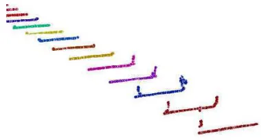
In the current study, 3D point clouds from MMS on pavement surface evaluated the pavement condition. As shown in Figure 1, the coordination data of cross-section pavement surface is extracted by a width of 50cm from 3D point clouds which is measured by 10cm pitch. From this, about 250 points data on the range of road width (5m) and longitudinal length (50cm) is extracted as an evaluated data of single surface area. The data of each surface area is made in 5m pitch for longitudinal direction continuously.
3.2 Chow-test and F-test model
A damaged point of pavement is evaluated by Chow-test and F-test model.(Morimune, 1999) The Chow-F-test is a statistical and econometric test of whether the coefficients in two linear regressions on different data sets are equal. The Chow-test is most commonly used in analysis to test the presence of a structural break.
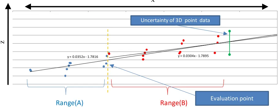
As shown in Figure 2, point data from MMS is plotted in cross direction of road. An arbitrary evaluation point is set and evaluation range is divided into 3 ranges as follows: 1) range A, 2) range B and 3) all range. And the parameter of regression model (least-square method) using each coordination data of range and residual sum of squares (RSS1, RSS2 and RSS) are
SSR1: residual sum of squares in range A
Figure 1. Extraction of 3D point clouds
International Archives of the Photogrammetry, Remote Sensing and Spatial Information Sciences, Volume XXXIX-B1, 2012 XXII ISPRS Congress, 25 August – 01 September 2012, Melbourne, Australia
SSR2: residual sum of squares in range A SSR : residual sum of squares in whole range n1 : number of data in range A
n2 : number of data in range B k : number of explanatory variable
Here, the following hypotheses are set.
Null hypothesis H0
: pavement condition of range A and range B is equal Alternative hypothesis H1
: pavement condition of range A and range B is different
F-value is computed by result of regression analysis and in the case that the hypothesis is rejected using a level of significance of 0.05, it is considered that that pavement of road is damaged. Also, the level of damage of surface condition is evaluated by F-value and the rate of the number of rejected points.
4. CASE STUDY
4.1 Outline of Case Study
The evaluation model proposed in this research is applied for actual road pavement. 3D point clouds from MMS are measured and pavement condition is evaluated by Chow-test using collections of data for road pavement managed by local government. Furthermore, the results between Chow-test and existing method of pavement condition survey were compared and the validity of evaluation method proposed in this research was assessed.
The target road for evaluation has length of 6km managed by local government and that road is semi- highway which had one lane for one direction. That road was constructed 30 years over ago and the damaged pavement sections were repaired by cutting overlay and replacement. Also, the road surface was dug up for construction, such as a gas pipe and burial of a sewer pipeline, and many marks of the construction were noticed
existing. The irregularity points of pavement are attributed to not only deterioration but marks of the construction.
The pavement condition survey in Japan evaluates the condition by Maintenance Condition Index (MCI)) and integrates the evaluation result of cracking, rutting and IRI. This MCI varies in the range from 10 to 0. The larger value of MCI indicates that the condition is better. This case study compares the results between Chow-test using 3D point clouds and MCI.
4.2 Result of analysis
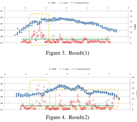
The results of Chow-test for arbitrary pavement section are shown in Figure 3 - Figure 5. These figures indicate F-value and coordinate value (XZ) of 3D point clouds. The horizontal axis shows the cross direction of road and the vertical axis shows the coordinate of Z and F-value. The section in Figure 3 has one point where is dented on surface and the F-value of that point shows large. In the case of Figure 4, the bump points are in some points on surface and F-values are also dispersed to horizontal direction. On the other hand, in the section in Figure 5, there is one point which has extremely the large number of F-value. That means there is a localized damaged point.
Figure 6 makes a comparison between MCI evaluated by pavement condition survey and the result by Chow-test. It is impossible to analyze the correlation directly between MCI and F-value due to difference of evaluation section range (evaluation length of pavement condition survey is 50m). For this reason, the whole tendency is represented by illustrating an evaluation result.
The upper part of Figure 6 indicates the maximum of F-value and the lower part indicates the rate of points which has bump on surface. There is no clear relationship between the maximum of F-value and MCI because MCI represents the average condition of pavement section, not localized damaged point. On the other hand, in the lower figure which shows the relation between the rates of points, has bump on surface and MCI, the evaluation result of Chow-test is consistent with MCI. From the above results, it can be said that the methodology proposed in this study makes it possible to evaluate pavement conditions by considering not only macro (average) but micro (localized) level. This indicated the possibility to evaluate the localized Figure 2. Basic idea of Chow-Test
y = 0.0352x - 1.7816 y = 0.0304x - 1.7895
x
z
Uncertainty of 3D point data
Range(A)
Range(B)
Evaluation point
International Archives of the Photogrammetry, Remote Sensing and Spatial Information Sciences, Volume XXXIX-B1, 2012 XXII ISPRS Congress, 25 August – 01 September 2012, Melbourne, Australia
damage point which was not evaluated by road condition survey (MCI value).
5. CONCLUSIONS
This research proposed the methodology to find the damaged pavement section effectively using 3D point clouds as a new approach for conducting inspection of the road maintenance work. Also, the case study represented that the bump on surface can be extracted and the validity of this method was described by comparing the result of pavement condition survey and Chow-test.
It is a future subject to apply on the maintenance work of actual pavement using the methodology proposed in the current study. When this method will be applied to actual maintenance work,
it would be necessary to estimate the cost for acquiring 3D point clouds from MMS and analyze the validity. However, when 3D point clouds are measured for several objectives such as updating of mapping data and urban planning, it is not necessary to acquire new 3D point clouds only for the road maintenance work. By using the already acquired data, it is possible to reduce inspection cost sharply. In this way, it is also an important issue that the advantage by sharing 3D point clouds is clarified and logic to use the data is well prepared.
REFERENCES
Madanat, S. (1993) Incorporating inspection decisions in
pavement management, Transportation Research, Part B,
Vol.27B, pp.425-438.
Madanat, S. and Ben-Akiva, M. (1994) Optimal inspection
and repair policies for infrastructure facilities,
Transportation Science, Vol.28, pp.55-62.
Aoki, K., Mori, H. and Okada, K. (2011) Effect of Pavement
Service Level upon Operation Timing of Periodical Inspection Policy, 7th International Conference of Pavement
Technology.
Morimune, K. (1999) Econometrics, Toyo Keizai INC. Figure 5. Result(3)
Figure 6. Comparison between Chow-Test and MCI
International Archives of the Photogrammetry, Remote Sensing and Spatial Information Sciences, Volume XXXIX-B1, 2012 XXII ISPRS Congress, 25 August – 01 September 2012, Melbourne, Australia