Research On The Classification Of High Resolution Image Based On Object-oriented And
Class Rule
Li Chaokuia,b, Fang Wena,b, Dong Xiaojiaoa,b
a、National-Local Joint Engineering Laboratory of Geo-Spatial Information Technology, Hunan University of Science and Technology ,Xiangtan, Hunan, [email protected]
b、Hunan province Engineering Laboratory of Geo-Spatial Information Technology, Hunan University of Science and Technology ,Xiangtan, Hunan, [email protected]
KEY WORDS: Object-oriented Rules High resolution Multi-scale segmentation
ABSTRACT:
With the development of remote sensing technology, the spatial resolution, spectral resolution and time resolution of remote sensing data is greatly improved. How to efficiently process and interpret the massive high resolution remote sensing image data for ground objects, which with spatial geometry and texture information, has become the focus and difficulty in the field of remote sensing research. An object oriented and rule of the classification method of remote sensing data has presents in this paper. Through the discovery and mining the rich knowledge of spectrum and spatial characteristics of high-resolution remote sensing image, establish a multi-level network image object segmentation and classification structure of remote sensing image to achieve accurate and fast ground targets classification and accuracy assessment. Based on worldview-2 image data in the Zangnan area as a study object, using the object-oriented image classification method and rules to verify the experiment which is combination of the mean variance method, the maximum area method and the accuracy comparison to analysis, selected three kinds of optimal segmentation scale and established a multi-level image object network hierarchy for image classification experiments. The results show that the object-oriented rules classification method to classify the high resolution images, enabling the high resolution image classification results similar to the visual interpretation of the results and has higher classification accuracy. The overall accuracy and Kappa coefficient of the object-oriented rules classification method were 97.38%, 0.9673; compared with object-oriented SVM method, respectively higher than 6.23% ,0.078; compared with object-oriented KNN method, respectively more than 7.96%,0.0996. The extraction precision and user accuracy of the building compared with object-oriented SVM method, respectively higher than 18.39%,3.98%, respectively better than the object-oriented KNN method 21.27%,14.97%.
1、INTRODUCTION
With the spatial resolution, spectral resolution and time resolution of remote sensing data has improved significantly, deeply mining and using all kinds of semantic association of remote sensing data, removing the interference factors effectively and improving the automation and accuracy of interpretation has become the main challenge of the development and application of high resolution remote sensing[4].The method of object-oriented classification [1-3] overcomes the defects of traditional high resolution remote sensing image classification. Not only make full use of a variety of knowledge extraction rules as the basis of the high complexity and difference of the high resolution image classification, and integrate the segmentation and classification to some extent, so as to realize the rapid and accurate classification of remote sensing images, improve the precision and speed of image classification. The research based on the remote sensing data of Worldview-2 Cuona County Zangnan area, using the OCRC method to classify and extracte the information of features effectively and accurately[6,10,11].On this basis, a new method of object-oriented and class rule classification (OCRC) of high resolution image classification has proposed in this paper. The OCRC by the discovery and excavate the rich knowledge of spectral and spatial characteristics of high resolution spectral image, establish image object segmentation and classification structureat
multiple levels of network , the classification results and object-oriented nearest neighbor classification method classification results were compared and analyzed. The results show that: the OCRC is proposed in this paper has obvious advantages in the image building extraction accuracy and user accuracy.
2、OBJECT-ORIENTED AND RULES OF INFORMATION EXTRACTION METHODS
2.1 STUDY AREA AND DATA SOURCES
The study area is located in the Cuona county of southern Tibet. Southern Tibet is the tropical area of the northest in the world distribution , warm and humid climate,plentiful hydrothermal conditions, with the "Jiangnan" said of Tibet. It’s the most complete altitudinal belts in parts of the world's , one of the most abundant water resources in the region of China. The main rivers Brahmaputra whole basin water reserves after the Changjiang River, and the whole basin water reserves of unit area and long river is the river in China for the first time Using the November 28, 2012 Worldview-2 remote sensing image as data source. Worldview-2 image including 0.5m panchromatic and 1.8 resolution multi spectral bands, with four standard spectrum (red, green, blue and near infrared). The pretreatment of remotely sensed images including the geometric correction, the image fusion and the image cropping.
2.2 The Best Segmental Scale
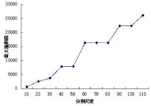
The phenomenon and process of surface entities are objectively true, and the phenomenon and process of research objects with different scales can show the complexity of surface entity[9].On an optimal scale clearly study and observe the research object geographical phenomenon, processes and the rules of geographical features, maintain the spatial structure characteristic consistent to the size of entity objects, that is the best segmental scale of features, which directly affect the classification results and accuracy. This paper uses the mean variance method, the maximum area method (Huang Huiping, 2003), the precision comparison method to select the optimal segmental scale of all kinds of features. This experiment select
the scales of 10,20,30,40,50,60,70,80,90,100,110 to partition experimental area. The results of the experiments presented, the optimal segmental scale of mean-variance method is 30,60,80,the optimal segmental scale interval of maximum area method is (40,50),(60,80),(90,100). And the segmental scale of precision comparison method in buildings, water, vegetation, bare land, road, at respectively 30, 80, 60, 20, 30, the classification accuracy reached maximum value. (As shown in Figure 1, Figure 2 and Figure 3).In conclusion, choose the segmentation scale of 80 to distinguish water and non water, the segmentation scale of 60 to distinguish vegetation and non vegetation in non-water, the segmentation scales of 30 to distinguish buildings, roads and bare land in non-vegetation.
2.3 ANALYSIS OF SPECTRAL AND SPATIAL FEATURES OF GROUND OBJECTS
2.3.1 Spectral Imprints: Through the overall observation and analysis of the images, in this paper, the study area is divided into five features, that is vegetation, water, roads, bare land and building, select and observe how changes in the image spectral characteristics of these five samples(shown in Figure 4), and summarize their characteristics. Finally, according to vegetation, water, roads, bare land and building ,30 size for 10-15 typical regional pixel sample were selected respectively on the image .Experimental results show that the separability between each object class of training samples were greater than 0.8, separation is better and suitable for the spectral analysis as the training sample.
By collecting and analyzing a large number of characteristics and changes of the ground object features typical values, using the spectral correlation relationship, summarize some outburst feature and distribution law ,so that it can fully reflect the attributes and spatial distribution of the surface of objects.
The NDVI values of the vegetation is very different with other ground feature categories. The NDVI values of vegetation is the highest in all types, the average value is greater than 0.6,while the average NDVI values of the other land is less than 0.2. (Figure 5 (a)). The NDVI values of water bodies and other surface features is significantly different, which shown as white in the result picture, and the range of the water body index is usually between [0.29,0.6] (Figure 5 (b)).
Figure 1. Relationship between segmentation scales and mean-variance
Figure 2. Relationship between segmentation scales and maximum area values
(a)Building (b)Water (c)Vegetation
(d)Bare land (e)Roads
Figure 3. (a)-(e) Relationship between scale and precision
The typical spectral characteristics of surface features showed in Figure 4, the roads brightness value is: Band 2>Band 1>Band 4>Band 3, the building brightness value is Band 2>Band 1>Band 4>Band 3. In order to separate the roads and the building, the F = (B1-B4) / B1 is greater than the threshold value 0 is for the building while the threshold value less than or equal to 0 is for the roads, which were obtained by the spectral characteristics analysis and repeated tests. In the Worldview-2 images, while the characteristics of bare land, roads and buildings is quite obvious which can be distinguished by visual, however, because the order of magnitude to the brightness mean value change of the bare land, the part of roads and the buildings (white) is similarity, and were showed white in the image spectra. Therefore, in order to distinguish the bare land, the part of roads and white building, that the threshold value of B2, when greater than 640 is for the buildings, less than or equal to 640 and greater than or equal to 450 is for the bare land, and less than the 450 is for the road.
2.3.2 Spatial Features: Shape feature is a very important feature of target recognition and classification in high resolution image. Object-oriented classification is based on the object as the basic classification unit, the shape features of objects can scientific calculated by mathematical tools, artificial intelligence and nonlinear systems, thus, it can accurately reflect and describe the shape of the surface real features. The study will choose aspect ratio features, width feature, suitability for rectangle, curvature, standard deviation of curvature and density characteristics as the classification rules. The scale of 30 segmentation results as shown in Figure 6 below.
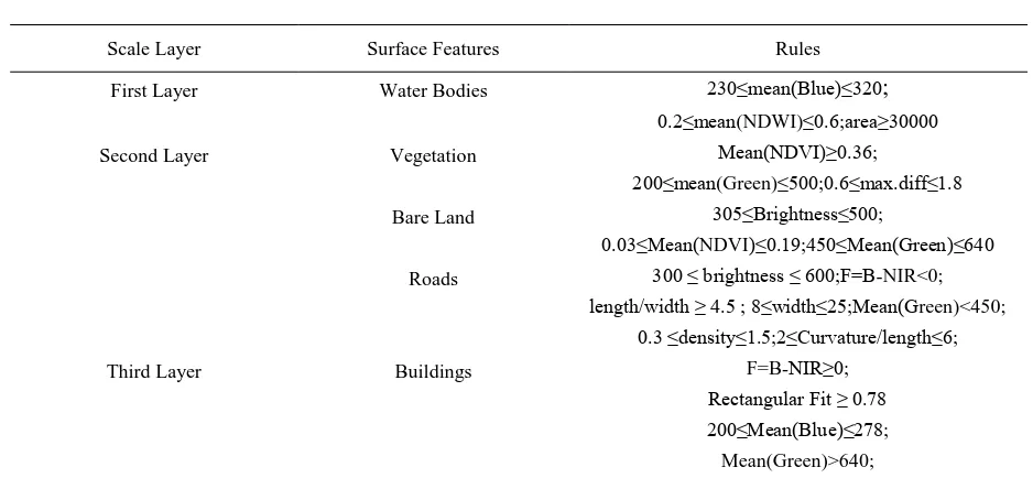
2.4 CLASSIFICATION RULES AND HIERARCHY
After image segmentation, high resolution image features with high complexity and difference are extracted by different knowledge of characteristics. Through the transfer of multiple levels to make the hierarchy has the inheritance relationship, constitute complex intellectual structure network of rules ,to achieve the hierarchical classify of various features in the image highly efficient and accurate. This paper takes Ecognition8.7 as the platform, comprehensive utilization of spectral, shape, texture and context information of the each level object category in the image, select the appropriate classification feature or combination, set up classification rule set of all kinds of surface features. According to feature knowledge analysis and extraction in the study area, establish the stratification system and classification rules of water bodies, vegetation, buildings, roads, bare ground, to hierarchical classify Worldview-2 images (Table 1).
Scale Layer Surface Features Rules
First Layer Water Bodies 230≤mean(Blue)≤320;
0.2≤mean(NDWI)≤0.6;area≥30000
Second Layer Vegetation Mean(NDVI)≥0.36;
200≤mean(Green)≤500;0.6≤max.diff≤1.8
Bare Land 305≤Brightness≤500;
0.03≤Mean(NDVI)≤0.19;450≤Mean(Green)≤640 Roads 300 ≤ brightness ≤ 600;F=B-NIR<0;
length/width ≥ 4.5 ; 8≤width≤25;Mean(Green)<450;
0.3 ≤density≤1.5;2≤Curvature/length≤6;
Third Layer Buildings F=B-NIR≥0;
Rectangular Fit ≥ 0.78
Figure 6. Results of all kinds of shape features
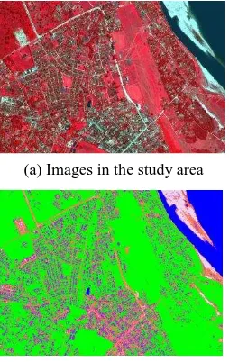
3、ANALYSIS OF EXPERIMENTAL RESULTS The comparison of the reference object inspection sample of known classification and the specific objects in classification images is carried out by experiments. Using the confusion matrix accuracy evaluation method to calculate the user accuracy, producer accuracy, total precision and Kappa coefficient of the classification results, and the results of image information extraction was evaluated. Figure 7 (b) and Table 3 is the object-oriented and class rules classification results and classification accuracy evaluation form. The OCRC overall classification accuracy up to 97.38% and kappa coefficient was 0.9673, the producer and user accuracy of building were as high as 91.67% and 96.37% respectively. The result of experiment shows that the OCRC is better. It can effectively distinguish the roads ,bare land, buildings, which have similar spectral information, integrally extract all types of surface features information. By discovery and mining characteristic knowledge of five kinds of surface features, select object features that were same with the object-oriented and class rules for SVM and KNN, and a total of 20 feature indices were selected: spectra, shape, vegetation index, water index, etc. (Table 2). Figure 7 (c), Figure 7 (d), Table 4 and 5 is classification results and accuracy evaluation respectively of the object-oriented SVM classification[5,7,8] and the object-oriented KNN classification.
Category Image object features Quantity
Spectrum Mean 4
Standard deviation 4
Brightness 1
Max-diff 1
Shape Area 1
Length 1
Width 1
Length/width 1
Asymmetry 1
Density 1
Rectangular fit 1
Shape index 1
Vegetation Index NDVI 1
Water Index NDWI 1
Total 20
Class Vegetation Water Bare Land Roads Building Total
Vegetation 360 0 0 0 0 360
Water 0 365 0 0 1 366
Bare Land 0 0 353 0 19 372
Roads 0 0 6 352 9 367
Building 0 3 1 8 319 331
Total 360 368 360 360 348 1796
Producer Accuracy 100.00 99.18 98.06 97.78 91.67
User Accuracy 100.00 99.73 94.89 95.91 96.37
Overall Accuracy=97.38%,Kappa = 0.9673
(d) Result of the object-oriented KNN classification Table 2. Total of image objects features
(a) Images in the study area (b) Result of the OCRC
(c) Result of the object-oriented SVM classification
Figure 7. Classification results of three methods
4、CONCLUSION
A remote sensing image classification method based on object-oriented and rule is proposed. The OCRC, object-object-oriented SVM classification method and object-oriented KNN classification method were compared and analyzed. The results showed that:
(1) object oriented classification method can very effectively using the spatial information characteristics of the true surface features, such as area, shape, length, aspect ratio, suitability for rectangle, to take part in the images classification process , especially for the object types that are metameric substance of same spectrum effect is obvious.
(2) Producer accuracy, user accuracy, overall accuracy, kappa coefficient of buildings, roads, bare land, water, vegetation that are concluded from the OCRC are higher than object-oriented SVM method and object-oriented KNN method. Among them: the total accuracy of OCRC was 97.38%, respectively, higher than the oriented SVM classification method and object-oriented KNN classification method 6.23%, 7.96%. The Kappa coefficient was 0.9673, which were 0.078 and 0.0996 respectively higher than the object-oriented SVM classification method and object-oriented KNN classification method. The producer accuracy and user accuracy of buildings were 18.39% and 3.98% higher than those of the object-oriented SVM classification method, and 21.27% and 14.97% higher than the object-oriented KNN classification method.
(3) By using object-oriented multi-scale segmentation, the image objects that are similar with the physical size of the image features can be generated. And the result and accuracy of this classification are more accurate than the conventional pixel-based classification method. Including: The OCRC through discovery and mining characteristic knowledge of of true surface features on the image, establish the classification rules of features, and, the classification results arrived from OCRC are better than the object-oriented classification method of supervision, such as object-oriented SVM classification method and object-oriented KNN classification method. In addition, The OCRC has higher precision.
ACKNOWLEDGEMENTS
Supported by the National Natural Science Foundation of China (NO.41271390), the Open Foundation of NASG Key Laboratory of Satellite Mapping Technology and Application (KLAMTA-201406), Cooperative Research Project of Dam-Break Flood Dynamic Development Analysis and Assess Damage (2011DFG 23330).
REFERENCES
Baatz M, Schape A., 1999.Object-oriented and multi-scale image analysis in semantic networks. In: Proc of the 2nd International Symposium on operation alization of Remote Sensing. August16~20th. Enschede ITC.
Baatz M, Schape A., 2000. Multiresolution segmentation: an optimization approach for high quality multi-scale image segmentation. Angewandte Geographische Information sverarbeitung XII: 12-23.
Table 4. Accuracy assessment of the object-oriented SVM results
Cao Y.T., 2011. Research on land use classification rule set based on QuickBird satellite data. Geography and Geographic Information Science, pp. 27(6): 28-31.
Chen J., 2011. Object-oriented classification of high resolution remote sensing image based on support vector machine and granularity computing. Science of Surveying and Mapping, pp. 2(40) 128-134.
Huang H.P., 2003. Study on the scale problem in object image analysis. Beijing: Graduate University of Chinese Academy of Sciences, pp. 74-82.
Ketting R.L., 1976. Computer Classification of Remotely Sensed Multispectral Image Data by Extraction and Classification of Homogeneous Object. IEEE Transactions on Geoscience Electronics, pp.14(1): 19-26.
Lv Y.H., 2001. Scale and scale conversion method in ecology. Acta Ecologica Sinica, pp. 2096-2105.
Rego, L.F.G., 2007. Automatic land-cover classification derived from high-resolution IKONOS satellite image in the urban Atlantic forest in Rio de Janeiro(Brazil) by means of an object-oriented approach. Applied Remote Sensing for Urban Planning, Governance and Sustainability, pp.25-36.
Yan L., 2010. Remote sensing image processing experiment tutorial. Wuhan: Wuhan University press, pp. 24-30.
Yan L., 2012. The extraction of high resolution remote sensing images based on Rules. Journal of Wuhan University (Information Science Edition), pp. 37(6): 636-639.