LINKING BUILDINGS, ARCHIVES AND MUSEUMS OF THE 19
THCENTURY TURIN’S
CULTURAL HERITAGE
R. Tamborrinoa, F. Rinaudoa,*
a Politecnico di Torino – DAD, Viale A. Mattioli 39, 10125 Torino, Italy- (rosa.tamborrino, fulvio.rinaudo)@polito.it
KEY WORDS: Documentation, GIS, 3D modelling, digital history, urban history, data integration
ABSTRACT:
The documentation of Cultural Heritage asset is the basis for all the interventions and policies on Cultural heritage conservation and management. The documentation is mainly based on historic knowledge and metric survey. As far as historic knowledge is concerned many information are still recorded and preserved inside written documents that are usually not easy to reach and correctly understandable by all the experts that have specific responsibilities on Cultural Heritage.
The digitalization of documents (hardly faced in the last years) is not sufficient to guarantee the effective access to the historical information useful inside a documentation process. The documentation always needs an historical interpretation based on a critical reading produced by linking heterogeneous materials. Iconography also is an important source when it is correctly interpreted and linked to other sources. IT development and digital technology diffusion allowed offering new way to record, organize and share historical information: GIS and 3D modeling can be used as standard approaches to transfer the historical knowledge in a proper way to specialists involved in Cultural Heritage conservation and management. They have been generally used as tool to represent information for different targets, the ones mostly for specialized users, the others for edutainment. GIS are largely diffused yet in the Cultural Heritage management, and 3D modeling is wide spread used in museums communication. Nevertheless, both of them have more potential. They could be integrated in order to manage different data set related with the same matter. They could be used to make new research by surveying and improving interpretation in a way ready to transmit the outcomes. To produce a new generation of affordable digital historical products is necessary that the GIS and 3D modeling design and realization would be developed in a multidisciplinary approach that must be explained and demonstrated to the people that in the future will offer to the community this expertise.
The paper describes a teaching and research training experience started two years ago at the Politecnico di Torino in the master course on Architecture (Conservation).
1. INTRODUCTION
The documentation of Cultural Heritage is the focus of CIPA activities.
In the previous years, many efforts have been done to define, from a disciplinary point of view, this topic. RECORDIM was a milestone in this effort by putting together the users of the documentation and the providers of the basic data in order to find out modern and updated way to give a strong platform to develop new way to collect and to link the basic data needed for a complete documentation.
As stated in one of the main products of the RECORDIM initiative the documentation is “The already existing stock of information. As an activity, it stands for the systematic collection and archiving of records in order to preserve them for future reference” (Letellier, 2007).
The term “information” means a set of data coming from one or more disciplines connected by a critical interpretation made by experts.
As stated in almost all the international doctrinal texts referring to immovable cultural heritage (Athen’s charter, Venice’s charter, etc.) a basic knowledge of the Cultural Heritage is the starting point for every intervention policy and this documentation has to be stored, preserved and make accessible in the best possible way.
In the past, those recommendations were interpreted and translated in terms of national and international archives collecting by using different strategies all the documents (reports, books, pictures) related to Cultural Heritage assets.
In the 80’s of the last century, a huge effort transformed almost all the national archives in digital form: texts, iconography and video are now accessible by using digital platforms: those digital archives reached a new way of conservation of historical records and allow a worldwide diffusion of knowledge and accessibility trough internet. The digitisation operated at that time is still a passive way to access the information: “passive” means, in this context, the possibility to visualize the data or to extract the possible interpretation just by reading in a digital way the results of the researches performed on those data usually transmitted inside reports and books.
The use of GIS technology in Cultural Heritage documentation opened the door to a more intelligent transmission of the research results: archaeology and digital history are the two disciplines, which used in the best way this technique to record, manage and interpret the data.
Digital history is now trying to use GIS and 3D modelling strategies also to transmit the results of the historical interpretation thanks to the developments of the software solutions able to offer to researchers new instruments to analyse and show the complete historical research path: original data collection, data integration and interpretation, diffusion of intermediate and final results.
Disciplines of Digital Urban History and GIS/3D modeling for Cultural Heritage are merged to face the historical documentation of an urban context. By conceiving the 19th Century Cultural Heritage in Turin as part of the urban history, the keynote of the research training is to use digital ISPRS Annals of the Photogrammetry, Remote Sensing and Spatial Information Sciences, Volume II-5/W3, 2015
approach in historical research in order to visualize how the Cultural Heritage was conceived in the city growing up at that time and what kind of documentation is now available. The research focus on the architectural drawings conceived by the most relevant architect at that moment, well known just for one among the many buildings and plans he really conceived. The goals may be to provide documentary evidence of the whole of his architectural production as a strong contribution of the urban development in 19th Century and to organize the linked data. The collected documentation is used to survey the Cultural Heritage within the urban history by linking and making understandable written documents and architectural drawings. Two different examples are developed by the students assisted by the teachers: the “translation” of published historical information extracted from the specific literature and transformed into GIS shape files and the historical research with direct sources about the development of a portion of an historical center by using archives data studied and connected by using GIS and 3D modeling strategies. Buildings and urban areas are linked to their documentation in archives, museums and libraries through digital tools. The first achieved results show how is possible to give to the future responsible for Cultural Heritage management update instruments by preserving the necessary serious approach of the historical research. Some of the developed research will be transferred to the City of Turin Museum, a GIS web based virtual museum realized to share affordable documentation about the history of the city. The following paragraphs offer a short overview of the GIS and 3D modelling potentialities for digital urban history researches running and transmission. Some example, developed during the teaching activities trained by the authors in the last two years at the Restoration master courses in Politecnico di Torino, will help to understand better the proposed strategy.
2. GIS
It is well known that GIS is a technology able to add to data new meanings and interpretation keys thanks to the localisation of different phenomena in a common geographical frame.
All the data usually considered for an historical reconstruction and/or interpretation may be upgraded if the relative and the absolute position in space and in time are considered.
For example, the simple geo-referencing of historical maps on modern maps allows one to understand the evolution of urban contexts. In the same way, the localisation of never realized designed urban developments may allow a better understanding of the places. Ideas and proposals sometimes conditioned the developments even if never realized. They definitely clarify the real ideas of an architect about the places where they acted in the past also enlightening the final decisions. Another interesting application of GIS technology is the possibilities to fuse in a unique support data coming from different archives and historical sources to interpret and understand mutual relationships. The use of GIS in the context of Urban History requires many efforts to define the features to be used and the list of attributes to be defined for each of them. One of the most intriguing part of this design is the complete definition of the glossaries and the meanings that the specialists assign to each of the possible values of the attribute. Actually, it is difficult to define normalized glossary because the huge variety of historical sources, the different
interpretation done by the historians, the different historical periods faced in a simple study do not allow a strong standardisation.
Research also never stops and new developments could change the evaluation of data. So historical knowledge basically needs flexible and not standardised tools in collecting data as well as in organising them in data set. Instead of that historians will consider tools as alien or irrelevant to the research.
For these reasons, it is mandatory to build up a strong documentation for each layer of the GIS project by defining gradually the real contents of the attributes and the used meanings for each of the glossary words.
Therefore, the GIS implementation needs a strong design before to start with the data collection and data entry, to avoid misunderstanding and continuous change of the data structure. The design runs with a multidisciplinary effort between historians and GIS experts by looking for the optimal solution of historical data management considering the limits of the IT adopted solutions.
It is impossible to define strict rules to be followed; the involved specialists have to be highly experienced on proper data management to be ready to find possible agreements to fit the requirements of the concurrent disciplines.
However, some basic rules can be stated to give a sort of path to be followed to reach the best possible result.
2.1 Geographic data basic rules
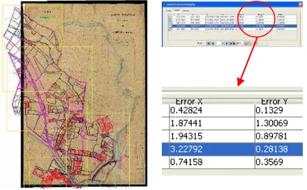
A GIS project can run in a multi-scale approach but the different maps are placed on different layers to avoid misunderstanding and confusions. The “nominal map scale” meanings of accuracy and level of detail are important for a correct management and interpretations of the other data. The different nominal scales of the used maps will influence also the level of detail of the database associate to them and have to be considered in order to select the best way to visualize the results. In case of historical maps, a correct geo-referencing strategy has to be adopted by considering the role of the specific map inside the study and the known metric information (e.g. reference and coordinate systems, unit measurement, epoch, etc.). Both in case of rigorous approach or local transformation, a consistent number of check points (e.g. points of known coordinates in the final system not used for the transformation) has to be adopted in order to give to the final users the real accuracy in terms of metric contents. A wrong appreciation of those values (e.g. the geo-referenced map has the same accuracy of the map used to define the transformation) may drive towards wrong interpretation of the data located on those maps.
Figure 1. Geo-referencing of an historical map: on the right the discrepancies on check points expressed in pixel units ISPRS Annals of the Photogrammetry, Remote Sensing and Spatial Information Sciences, Volume II-5/W3, 2015
As a rule it must be noticed that each resampling of a raster map increases the errors of the original raster map.
All the information about the instruments and methods used to generate the maps, the conservation situation of the original map are of strategic importance to drive correctly the geo-referencing process by an expert in cartography and survey. The selection of the specific transformations is important and has to be done by considering the metric origin of the historical map and the conservation level of the original paper: usually the affine planar transformation (roto-translation with two-direction scale factors) is the most suitable geometric model to be adopted.
Historical maps are historical sources and the correct description of the location of the original map has to be given to the users to allow the possibility to verify the original cartographic contents.
2.2 Database implementation
The database design is the most engaging step because it requires a deep strategy in research and its translation in terms of features, attributes and relationships. This effort is basic for the usability of the database as summary of the research outcomes.
The design development has to proceed in a “top – bottom” approach to create a logical structure form the lower up to the higher level of detail of the investigated objects.
For each object, the geometric feature (point, poly-line or polygon) is selected and the complete list of attributes defined in terms of type (e.g. numerical, date, string, logical, etc.) and glossary.
Once defined the hierarchy of the investigated objects, all the selected sub-objects will form a specific layer (or more layers in case of different geometric primitive adoption).
The design of the database is also the base for the organisation of the data capture. It also requires to be checked in the steps of the research in order to model information on the basis of the acquired data.
Considering the requirements of an historical research, all the data are documented in terms of quality by considering the different sources and by establishing a direct link to the specific source used. Therefore, a specific attribute has to declare where it is possible to access the original source and, if possible, to give a direct link to the digitized document, book or drawing. Today a lot of national museums, libraries and archives (both having digitized books, documents, pictures, videos, etc.) allow at least the visibility of digitized documents and in some cases also the possibility to download the raster document.
3. 3D MODELING
3D modelling is a well-known technology inside engineering and architectural disciplines more devoted to the design of new buildings and to the simulation of structural and physical phenomena. In those cases, the modelling is operated by using ideal quantities usually defined by the specialists by solving all the 3D geometric connections.
Another well known field of applications of 3D modelling technologies is the building up of realistic 3D models by using surveyed data (e.g. from laser scanner, digital photogrammetry, etc.). In this last case, the 3D geometric consistency of the generated model is harder to reach due to the inaccessibility and/or visibility of some parts of the object.
In addition, the use of surveyed 3D points (usually at different level of precision) requires more expertise in data management and shape comprehension.
In the last few years archaeologist has used them deeply in order to visualize the remains of the archaeological sites. They make understandable a very ancient period the documentation of which is just in the excavated materials.
By considering historical research, the 3D modelling is usually adopted to understand the original design ideas by interpreting authentic design drawings and/or old metric survey representations usually transmitted by means of 2D drawings and or perspective and axonometric graphics. The aim of this kind of 3D modelling is to understand the original components of a building or of a set of buildings within their urban contexts.
The possibility to work on different logical layers allows separating the information by following the adopted research strategies (e.g. by subdividing following the time, the function, the real existence, etc.). In a way the layers are the translation of the interpretations keys. They allow the 3D models to go behind the aim of the visualisation in order to transmit information (i.e. for the interventions and policies on Cultural heritage conservation and management).
In all cases, also 3D models have to fit the meaning of “nominal scale” especially in terms of level of detail and in terms of congruency of the data.
Sometimes to reach the congruency of the 3D models, some detail have to be interpreted and simulated by the specialists; in this case all the information that are not directly extracted from historical sources have to be stored in a different layer of the 3D model to allow a correct reading of the 3D model itself. Data coming from archival sources and data supposed and inserted by specialists have different meanings and importance inside the historical study.
4. HYPERTEXTS
GIS and 3D model native files are instruments used during the analysis of the data by the specialists but not suitable for the final users of the historical research results. In fact, it is quite impossible to transmit the personal interpretation just by showing the data collected and the intermediate results. At the same time, some of the data generated can be of fundamental importance to show the results of the interpretation and to allow the final user to check and to redo the intellectual path of the research.
Traditionally the interpretation of the results are recorded by using written reports and books but those instruments are not suitable to let a free access to all the data that allowed the development of the specific research.
Therefore, hypertext could represents an ideal solution because a correct planning of them will allow the authors of a research to drive the reader along the intellectual path. It adds a storytelling to the research visualization by organizing information and representations in a stream. This task is very important especially for urban history as it comes out from heterogeneous documentations, which have not an immediate impact in the understanding of the relationships.
Hypertexts allow to transmit an interpretation key and to create a link among different kind of documentations telling a story about the matter.
Hypertexts also can link different applications able to make possible the access to the basic structure of the databases (e.g. shape files) and of 3D models (e.g. 3D pdf files). Those files ISPRS Annals of the Photogrammetry, Remote Sensing and Spatial Information Sciences, Volume II-5/W3, 2015
could be downloaded and then used for different purposes.
5. TURIN TRANSFORMATION IN 19TH CENTURY
Since the beginnings of the 19th century, the walls of Turin were demolished and the city started to grow up around. The city was among the more planned cities until that time, but it did not produce a complete vision of its planned enlargement. During the second half of the 19th century, many different partial plans were perfected to allow the growing up of the population and the use of areas around the old settlement of the town. The development of the industries arrived later, around the end of the century.
One of the most important actors of this period is Alessandro Antonelli, mostly famous as the architect of the “Mole Antonelliana” (symbol of the town). He developed many architectural proposals for the new parts of the town and some urbanistic plans for one among these (Borgo Vanchiglia). He conceived new ideas for many private residencies and for several public buildings in the new areas and demonstrated some possible modification for the historical centre of Turin. Not all his designs were realized (actually just few of them are visible today as Antonelli thought) therefore, it is difficult to understand the real design idea of Antonelli without a complete study of all his production, both realized and not realized designs. Some built buildings also changed and often are different from the original design. Anyway, they are not easily understandable in the urban context for which they were conceived. The rich documentation about them is well preserved but split among several archives, museums and libraries.
The multitude of the drawings and the designs he realized as well as the many subjects he approached are also strong points in the aim to survey the urban history. Through each story they visualize, the survey can contribute to enlighten part of the city history.
Drawings are in the related public archives, and are completed by the private archive of the architect well preserved also in the public archive. All the designs of Antonelli were catalogued (Rosso,1989) by using a traditional approach in historical study that is the drawings were used to describe the design.
By the research program, that information have been translated in a GIS project where the different designs are characterized with a set of attributes which allow one to understand better the whole work of Antonelli during his life. In the research program the GIS has been conceived as a digital archive and will become the first database on the subject.
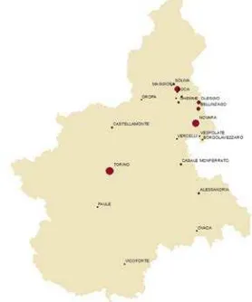
The project uses different scales: national (e.g.1:1.000.000), regional (e.g.1:10.000) and urban (e.g.1:1.000) scales. At each scale layer, a different set of attributes, by considering the level of detail of the different scales, have been used (see Fig. 2). All the designs were indicate by using point features at national and regional level and polygons at urban level. By using symbology and queries, it is possible to obtain different thematic maps able to demonstrate different aspects of the Antonelli’s designs by following the research strategy. By clicking on one of the 3D synthetic models, the GIS project redirect the user in a separate hypertext which describe more in detail the historical research done on the specific design.
5.1 The “Fetta di polenta” house
The hypertexts are standalone websites, which allow the historians to drive the reader along the research path by giving the opportunity to verify all the results by accessing directly all the sources used to elaborate the research. Therefore, the structure of the hypertext is designed directly by the specialists by considering the individual choices to demonstrate specific arguments.
Province # Designs Historical period
Torino 37 1824-1881
Novara 41 1826-1888
Biella 1 1856-1876
Vercelli 4 1834-1853
Alessandria 5 1842-1863
Figure 2. Attribute tables at national (up) and regional (low) level
Hypertexts are used, in this case, to collect in a congruent approach all the possible information coming from the historical source analysis. All the realized hypertexts (one for each of the Antonelli’s designs) allow the user to follow the author’s idea and/or to create personal reading paths. Each time an historical source is used to state something, the user may download a digital version of the original documents and/or access to the website form where it is possible to download or at least to see the source that was used.
Figure 3. Antonelli’s design selected by “Town”; a proportional symbology describe the number of design
realized for each town
Object Town Year Source Realised
Duomo di Novara. Main altar
Novara 1832 Franco Rosso,
Alessandro Antonelli
Novara 1850 Daniela Biancolini, Il
secolo di Antonelli
Torino n.d. Daniela Biancolini, Il
secolo di Antonelli Novara 1798-1888, Novara, De Agostini, 1988
N
When 3D models and/or thematic maps are used, the user may download the corresponding native files (shapefile or 3Ddpf) or directly access the GIS project or the 3D model in an editable form.
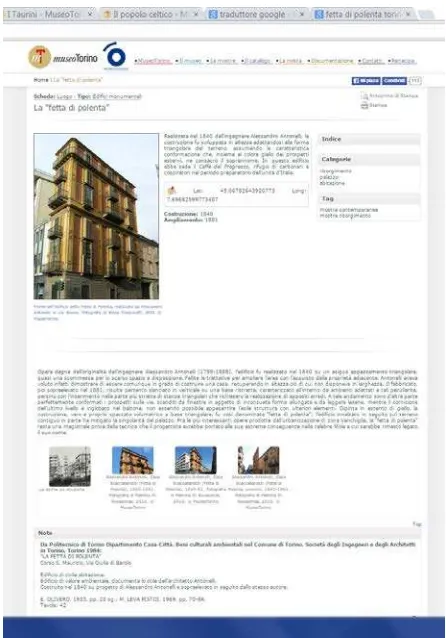
As an example, let us consider the case of “Casa Scaccabarozzi”, known in Turin as “Fetta di polenta”.
The realized hypertext shows the naissance of this strange-shaped house by using GIS visualizations.
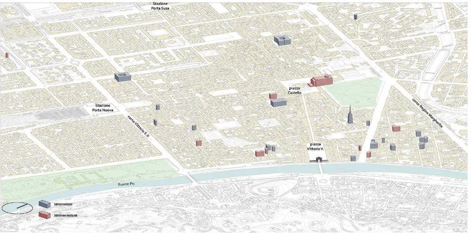
Figure 4. Location of Antonelli’s design inside Torino. The red ones are the not realized designs
Figure 5. The “Fetta di polenta” evolution at urban scale
A 3D model realized in 1:100 scale, allow the user to understand the different part of the house. The house is visualized in the urban area growing up around the old city. The Borgo Vanchiglia also was conceived as an enlargement by a proposal of the architect. The 3D shows as the plot was generated by the change produced in the area by the town planning of a new street, and the consequently modifications at the building conceived by Antonelli.
Videos introduce the time notion (the interval) in the space representation. The sequence reconstructs the creation, the variation and the building up in the urban site.
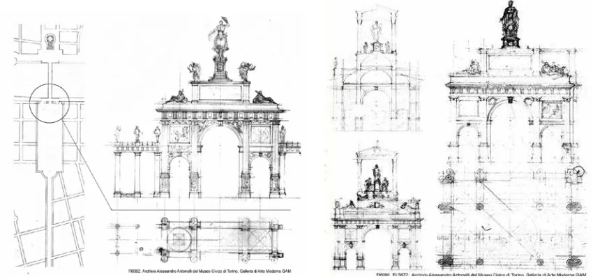
5.2 The new square Vittorio Emanuele
Vittorio Emanuele square is the biggest squares of Turin created after the walls were demolished by Napoleon at the beginnings of the 19th century. In the occasion of the return to Turin of the king Carlo Alberto for the restoration of his power, Antonelli envisaged a design of a triumphal arch in honour of the king at the end side of the square. The Antonelli’s idea, never realized, shows the will to modify the dimension of the town by inserting big buildings never seen in Turin although envisaged in the Napoleonic years.
Figure 6. The “Fetta di polenta” structure
The same scale he conceived for the Mole, the only one he could finally built.
Figure 7. Photorealistic 3D models of the triumphal arch in Vittorio Emanuele square
Figure 8. Original drawings with the catalogue number used by the City museum archive.
The 3D models realized by using the original drawings, have been inserted inside photographic images of the squares to demonstrate the above-mentioned idea. The hypertext allows the check-up of the realized models by giving the opportunity to access the original drawings just preserved as figures of an old journal published at that time. Drawings in museums, libraries, and archives are virtually gathered by digital tools that could be useful for different uses.
6. THE MUSEO TORINO
The Museo Torino (www.museotorino.it) is a growing idea of a city museum borne in 2011 by the city cultural program. It is based on a GIS project where the interesting monuments and places of the town are recorded as points. Each point allow the user to link a specific document where basic information about the selected object are offered and some interesting links to more specific website are offered.
The “collection” of the museum is the town itself and the adopted technology allows an easy access also by using i-phones and tablets, much-diffused peripherals always used by tourists and visitors. The Museo Torino was awarded by ICOM in 2011 for the Information and Communication Technology. It has not a specific location: it lives on the
network and everyone can access the information at every time and from every location. Completely developed as WEB3.0 or Semantic WEB it uses the most recent standard for the organization and archiving which allow an easy indexing by research engines (e.g. Google) and social networks (e.g. Facebook) by splitting the terms by following their own meaning and context. Thanks to this approach, all the contents of the Museo Torino can be related to all the other contents of the Web. The adoption of the Linked Open Data philosophy offers an open and easy access to database.
Figure 9. The WEBGIS of Museo Torino ISPRS Annals of the Photogrammetry, Remote Sensing and Spatial Information Sciences, Volume II-5/W3, 2015
Figure 10. The “Fetta di Polenta” designed and realized by Alessandro Antonelli.
The webpage offers some basic inquiries that allow the user to select the objects by using some research keys as historical period, specific arguments, etc. The Museo Torino link some digitized archives as libraries, picture collections, etc. by allowing the free download of the digitized sources.
The project is conceived as a “continuously growing system” where all the specialists, students, and citizens are invited to offer to the museum new documents and information. All the collected information, after a rigorous check by the scientific council, will than linked to the virtual museum and make available for all the visitors. The Historical Archive of the City now manages the website and the project.
By thinking to this structure, the examples described in previous paragraphs could be linked to the “hot-points” of the Museo Torino main page to offer the possibility to go into deeper analysis of the whole Antonelli’s designs. In this way the visitors can access to the results of the research over the Antonelli’s ideas by visiting a specific location or through a specific virtual exposition, which allow the selection of all the hot-points, related to the specific argument. That way all documentation about buildings and urban areas related to the Antonelli designs for Turin could be also available for different uses.
7. CONCLUSIONS
GIS and 3D modelling are today mature techniques that can be used to develop and transmit historical researches.
GIS projects have to be carefully designed to assist the specialists during their analysis and giving to them the opportunity to test different interpretations to look for the correct one.
3D models are conceived as practical instruments to understand at different scales the original designs and trough them to better understand the architect’s ideas. In this research program, this approach aims to understand how these ideas fit or contribute at the city change.
Hypertexts seem to be one of the possible way to connect all the interpretation path in a way comprehensible for different skilled users. In fact, it is possible to design different reading path for specialists who have to be able to verify the hypothesis and to check the correctness of the data.
Both GIS and 3D model original files has to be downloadable to guarantee the documentation principle of diffusion of the original data to be used also for different purposes (e.g. restoration, enhancement, management, etc.).
The same instruments can be used to transform the existing literature into digitally manageable data allowing a real migration from a passive digitisation toward an active digital translation of the knowledge.
The approach experienced by this research training shows as digital tools obtained will be something different and new. Digital adds new possibilities to survey and to manage a large quantity of data that are the basic of the historical research. If databases and visualizations model information, they also improve the understandings.
The challenge of the digital approach is in conceiving the Cultural Heritage as a field were the open data and the implementation in research has to be shared by all the operators. The goal of the digital tools for the Cultural Heritage has to be consequently in platform that could be implemented or modified by future research.
Hypertexts are actually standalone websites that can be linked to the network and made accessible by using every kind of device (e.g. smartphones, tablet, PC, etc.).
Figure 11. The description of the “Fetta di Polenta” and the link to main historical sources (e.g. books, pictures, drawings,
etc.)
The conceivable diffusion of this kind of media allows one to imagine a new structure for City Museums. They are becoming more and more the place to share the knowledge about the Cultural Heritage. By digital potential they could also improve in the interaction with people (specialised or not specialised) in order to build up a shared notion of the collective memory.
ACKNOWLEDGEMENTS
The figures of the present paper are based on the final works developed by the students of the course “GIS for Cultural heritage and Digital History” at the Politecnico di Torino in the academic year 2013-2014.
Chapters 2, 3 and 4 are under the responsibility of Fulvio Rinaudo. Chapters 5 and 6 are under the responsibility of Rosa Tamborrino. Introduction and conclusions are under the responsibility of both the authors (50% each).
REFERENCES
Agapiou, A., Alexakis, D. D., Lysandrou, V., Sarris, A., Cuca, B., Themistocleous, K., & Hadjimitsis, D. G., 2015. Impact of urban sprawl to cultural heritage monuments: The case study of Paphos area in Cyprus.Journal of Cultural Heritage.
Alves, D., & Queiroz, A. I.,2015. Exploring Literary Landscapes: From Texts to Spatiotemporal Analysis through Collaborative Work and GIS. International Journal of Humanities and Arts Computing, 9(1), 57-73.
Andreetto, M., Brusco, N., & Cortelazzo, G. M., 2004. Automatic 3D modeling of textured cultural heritage objects. Image Processing, IEEE Transactions on,13(3), 354-369.
Chías, P., Abad, T., Echeverría, E., Da Casa, F., & Celis, F., 2006. A GIS in Cultural Heritage based upon multiformat databases and hypermedial personalized queries.
Colley, S., 2015. Ethics and Digital Heritage. In The Ethics of Cultural Heritage(pp. 13-32). Springer New York.
Dell'Unto, N., Landeschi, G., Leander Touati, A. M., Dellepiane, M., Callieri, M., & Ferdani, D., 2015. Experiencing Ancient Buildings from a 3D GIS Perspective: a Case Drawn from the Swedish Pompeii Project. Journal of archaeological method and theory.
De Masi, A., 2015. Documentation, Digital Survey and Protection for a Multidisciplinary Knowledge of Some Urban Historic Landscape in Italy. InEngineering Geology for Society and Territory-Volume 8 (pp. 351-356). Springer International Publishing.
Duran-Dominiguez G., Felicisimo A. M., Snchez-Soto P. J., 2014. The representation of Cultural Heritage: Methodologies for digital characterization. Science, Technology and Cultural Heritage, 363.
Ferretti, V., & Comino, E., 2015. An integrated framework to assess complex cultural and natural heritage systems with Multi-Attribute Value Theory. Journal of Cultural Heritage.
Gaitatzes, A., Christopoulos, D., & Roussou, M., 2001. Reviving the past: cultural heritage meets virtual reality. In Proceedings of the 2001 conference on Virtual reality, archeology, and cultural heritage (pp. 103-110). ACM.
Guidi G., Russo M., 2011. Reality-based and reconstructive models: digital media for cultural heritage valorization. SCIRES-IT, 2011,1(2): 71-86.
Hanna, S. P., Potter, A. E., Modlin, E. A., Carter, P., & Butler, D. L. (Eds.)., 2015. Social Memory and Heritage Tourism Methodologies. Routledge.
M., Fernández, J. L., Gil, Á. M., Gómez-García-Bermejo, J., & Casanova, E. Z., 2010. A practical approach to making accurate 3D layouts of interesting cultural heritage sites through digital models. Journal of Cultural Heritage, 11(1), 1-9.
Letellier, R., 2007. Recording, Documentation, and Information Management for the Conservation of Heritage Places. Guiding principles. The Getty Conservation Institute, USA
Hanna, S. P., & Hodder, E. F., 2015. 11 Reading the commemorative landscape with a qualitative GIS. Social Memory and Heritage Tourism Methodologies, 210.
Pavlidis G. et al., 2007. Methods for 3D digitization of cultural heritage. Journal of cultural heritage, 8.1: 93-98.
Presner, T., Shepard, D., & Kawano, Y., 2014. Hypercities Thick Mapping in the Digital Humanities.
Rosso F., 1989. Alessandro Antonelli 1798-1888. Electa
Reunanen, M., Díaz, L., & Horttana, T., 2015. A Holistic User-Centered Approach to Immersive Digital Cultural Heritage Installations: Case Vrouw Maria. Journal on Computing and Cultural Heritage (JOCCH), 7(4), 24.
Slade, J., Jones, C. B., & Rosin, P. L., 2015. Semantic and geometric enrichment of 3D geo-spatial building models with photo captions and illustration labels.
Stephens, J., & Tiwari, R., 2015. Symbolic estates: community identity and empowerment through heritage. International Journal of Heritage Studies, 21(1), 99-114.
Yang W., Cheng H., Yen Y., 2014. An Application of GIS on Integrative Management for Cultural Heritage-An Example for Digital Management on Taiwan Kinmen Cultural Heritage. In: Digital Heritage. Progress in Cultural Heritage: Documentation, Preservation, and Protection. Springer International Publishing, p. 590-597.
Villa, D., 2015. Crowdsourced Heritage Tourism Open‐Data,
Small-Data and e-Participatory Practices as Innovative Tools in Alps Cultural Heritage Topic: Information Technology and e-Tourism. In Cultural Tourism in a Digital Era (pp. 229-230). Springer International Publishing.
Wüst, T., Nebiker, S., & Landolt, R., 2004. Applying the 3D GIS DILAS to Archaeology and Cultural Heritage Projects Requirements and First Results.International Archives of Photogrammetry Remote Sensing and Spatial Information Sciences, 35(Part 5), 407-412
http://www.hypercities.com/ (last access 08.04.2015)