Client : Dept. of Urban Development, Govt. of Delhi
C
C
H
H
A
A
P
P
T
T
E
E
R
R
-
-
5
5
LAND MANAGEMENT & URBAN GROWTH
5.1 INTRODUCTION
Delhi is located strategically on two National Highways (NH-2 & NH-8) that connect Delhi to Kolkata and Mumbai. NH-2 & NH-8 are two prime vertices of the Golden Quadrilateral Corridor of the National Highways Development Project. The city attracts a migrant population of 645 per day from various part of the country, mainly from the northern region. In order to control the unprecedented growth of Delhi, the approach of ‘planned decentralization’ has been suggested as per the MPD-1961 & 81 and NCR Plan 2001 & 21.
This chapter deals with the physical growth trends and planning efforts undertaken in Delhi. An attempt has been made to understand future growth trends and issues related to urban development. The approach at the NCR level is presented in the box below:
5.2 CONSTITUENTS OF DELHI
The National Capital Territory, Delhi (NCTD) area consists of the following three municipal areas-
(i) New Delhi Municipal Corporation (NDMC) area at the core. This is the
imperial Delhi spread over an area of 42.74 km2 which was established in
1911. It comprises of government Offices & residential areas and commercial nodes with wide roads, parks and open spaces etc. The NDMC area is administered by an 11 member council comprising 3 MLA’s; five government officers and 2 civilians nominated by Central Government; and a chairperson appointed by Central Government. The Council reports directly to Central Government.
(ii) Municipal Corporation of Delhi (MCD) area, occupying 1397 sq. kms, or most of the area of the city. The MCD further comprises the following areas:
• Old Delhi comprising of the walled city (Shahajahanabad) and
densely built up areas between the Red Fort and the New Delhi Railway Station on the periphery;
Client : Dept. of Urban Development, Govt. of Delhi
• Civil lines along the Ridge and Delhi University area in the North with
large plots and open spaces;
• New colonies, which have come up in last 50 years on the Southern
and Western sides;
• New development across the Yamuna river comprising of Shahadara
in the North, Patparganj & Mayur Vihar in the South;
• 728 squatter settlements, spread over an area of 9.68 km2 all over
the NCT area.
• Around 185 villages in outer Delhi area and 135 urban villages
characterized by haphazard development with marginal municipal services etc. (outer Delhi is included in MCD limits and accounted for in the MCD area).
The MCD is administered by an elected council comprising ward councilors from each of the 137 wards in the area. (refer Section 13, “Institutional Arrangement”). The MCD reports directly to the Central Government.
(iii) Delhi Cantonment area between the Airport and the NDMC area, spread
over an area of 42.97 km2. The cantonment area is administered by the
Delhi Cantonment Board (DCB), which reorts directly to the Central Government (Ministry of Defence).
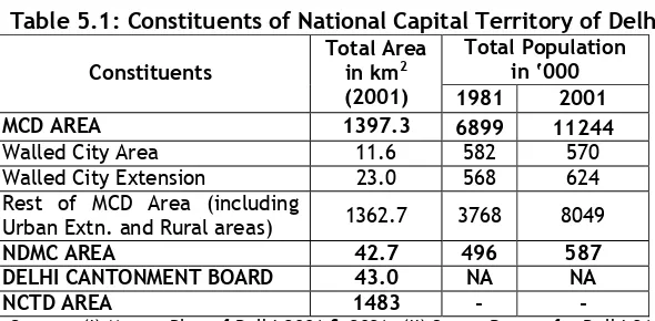
In 1999, the urban area of Delhi covered 701.62 Sq. Kms (Refer Table 5.1 and 5.2; and Figure 5.1).
Table 5.1: Constituents of National Capital Territory of Delhi Total Population
in ‘000 Constituents
Total Area in km2
(2001) 1981 2001
MCD AREA 1397.3 6899 11244
Walled City Area 11.6 582 570 Walled City Extension 23.0 568 624 Rest of MCD Area (including
Urban Extn. and Rural areas) 1362.7 3768 8049
NDMC AREA 42.7 496 587
DELHI CANTONMENT BOARD 43.0 NA NA
NCTD AREA 1483 - -
Source: (i) Master Plan of Delhi-2001 & 2021; (ii) Status Report for Delhi-21, Delhi Urban Environment and Infrastructure Improvement Project (DUEIIP), January 2001
Table 5.2: Delhi Area Statistics S.
No.
Item Area (Sq.
kms)
1. Total Area 1483
2. Urban Area* 701.62
(47.3%) 3. Natural Features to be Conserved** 195.09 4. Balance Area Available for Urbanisation 586.29 5. Addl. Area Proposed for Urbanisation (2021)*** 276.29 6. Proposed Urban Area (2021) 977.91 (66%)
* As per IRS-IC LISS 3 Satellite Data
Client : Dept. of Urban Development, Govt. of Delhi
Figure 5.1: Planning Division in NCTD Area
5.3 EXISTING CITY ASSESSMENT
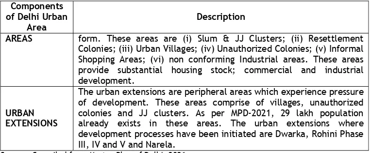
Delhi city region comprises of three components (i) Existing Urban Area; and (ii) Urban Extensions. The existing urban area has been classified as (a) Planned area; (b) Special Area; (c) Ecologically sensitive areas and (d) Unplanned areas. The descriptions of these areas are presented in Table 5-3.
Table 5.3: Description of Various Components of Delhi Urban Area
Components of Delhi Urban
Area
Description
PLANNED AREAS
The planned area of Delhi include (i) Influence area along MRTS and Major Transport Corridor; (ii) Lutyens Bunglow Zone; (iii) Chanakyapuri area; (iv) DIZ area; (v) Mata Sundari Area; (vi) Civil Lines Bunglow area; (vii) Other part of NDMC area;(viii) Planned built-up housing; (ix) Planned (Hierarchical) Commercial Area; (xii) Planned Industrial Area
SPECIAL AREAS
Special areas as defined on the plan cover about 2600 ha and have been divided into three separate parts (i) Walled City; (ii) Walled City Extension and (iii) Karol Bagh. These are characterized by a mix of different land uses and have similarities in built form.
UNPLANNED The unplanned areas are distributed homogenously across the urban
E
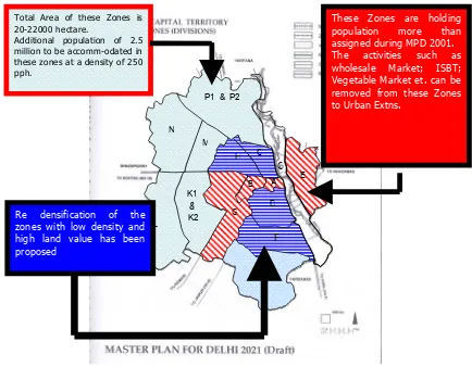
Total Area of these Zones is 20-22000 hectare.
Additional population of 2.5 million to be accomm-odated in these zones at a density of 250 pph.
These Zones are holding population more than assigned during MPD 2001. The activities such as wholesale Market; ISBT; Vegetable Market et. can be removed from these Zones to Urban Extns.
Client : Dept. of Urban Development, Govt. of Delhi Components
of Delhi Urban Area
Description
AREAS form. These areas are (i) Slum & JJ Clusters; (ii) Resettlement Colonies; (iii) Urban Villages; (iv) Unauthorized Colonies; (v) Informal Shopping Areas; (vi) non conforming Industrial areas. These areas provide substantial housing stock; commercial and industrial development.
URBAN EXTENSIONS
The urban extensions are peripheral areas which experience pressure of development. These areas comprise of villages, unauthorized colonies and JJ clusters. As per MPD-2021, 29 lakh population already exists in these areas. The urban extensions where development processes have been initiated are Dwarka, Rohini Phase III, IV and V and Narela.
Source: Compiled from Master Plan of Delhi, 2021
The development status of the city has been revised with respect to Existing Linear Development; Development in Special areas; Unauthorised / Unorganised Colonies; Housing Supply & Demand; Planned & Unplanned Commercial & Industrial areas and ecologically sensitive areas.
5.3.1 Influence Zone along Major MRTS and Major Corridors
The growth of Delhi over the years has been on a ring and radial pattern, with reliance on road based public transport. The development envisaged by previous plans was poly-nodal with a hierarchy of commercial centres located on either ring or radial roads. The proposed MRTS network has been acting as a development catalyst and has sizeable impact on the existing structure of the city.
5.3.2 Development Profile along Major Corridors
The road network can be categorized into four types i.e. Arterial roads, sub arterial roads, minor arterial road and collector roads. About 1100 km of road length are provided with right of way of 30m and above.
The road network comprising of ring and radial pattern has C.P. as a focal point with Mathura road, Lal Bhadur Shastri Marg, Aurobindo Marg, Rao Tula Ram Marg, Gurgaon Road (NH 8) Patel road, Shankar road, Rohtak Road, G.T Road (NH1), Loni road, Shahadra road, NH 24 bypass forming the radials while Mahatma Gandhi Road (Ring Road), Outer Ring road, Noida road- Bund road forming the prominent rings. These radial and ring roads serve as major arterials to carry bulk of traffic in the city.
These major corridors are high intensity development zones with planned and unplanned development along them. The predominant developments along the major corridors are presented in 4 & Figure 5.2.
Table 5.4: Development Intensity along Major Corridors of Delhi
Name of Corridor
Characteristics & Type of Development around 20km from Badarpur Border to Rajghat. It is one entry point to Delhi and has industrial,
• Encroachments at Jaitpur & Badarpur intersection reduce the carriageway width.
Client : Dept. of Urban Development, Govt. of Delhi Name of
Corridor
Characteristics & Type of Development
Problem
Quadrilateral institutional and residential development. At the entry point it is characterized by haphazard and unplanned growth residential & industrial areas in urban villages.
rainy seasons and lack of suitable drainage infrastructure
• Bottleneck at the entry point with industrial, commercial development and Bus & Truck parking
• Environmental degradation because of filling of water bodies and low lying areas for commercial uses such as petrol pump, Transport training institute, Sarai Kale Khan ISBT. NH-24 around 15km from Ghazipur to NH-2 intersection at IP Park. It was at Ghazipur which is a major fish & chicken market; and fruit & vegetable market of Delhi. It also has major garbage dumping site. It mainly traverses through haphazard development within urban villages and Patparganj & Mayur Vihar society complexes. The proposed site for common wealth games is also in proximity to this corridor.
• The corridor passes through low lying area and the development in the Yamuna Bed. It has unorganized development in villages such as Khicripur, Pandav Nagar etc.
• The corridor has been encroached by JJ clusters. These clusters are devoid of basic infrastructure facilities leading high interaction with the corridor.
• Low lying areas along the corridor are used for dumping of HH and construction wastes.
NH-1 (Delhi
The length of NH-1 from Samli border to TP Nagar Border is around 40 km. It traverses through Industrial areas
(Wazirpur, Jahangirpuri, Badli in North and Jhilmil & Shahadara in East), Institutional area (Delhi University, IP University, Old Secretariat), Resettlement Colonies (Babarpur, Saleempuri, Seemapuri et.al)
• High density industrial; commercial and unauthorized development
• Truck parking near the TP Nagar border in east with transport operators located along the corridor
• Encroachment on the corridor due to unauthorized
development have transformed the urban built form in the area along the corridor NH-10 (Delhi
It is around 25km in length in NCTD extending from Savdar Ghevra to Sarai Rohilla. It traverses through the urban extensions of Delhi, which have potential for future development. It is connected to Dwarka and Rohini through ring roads.
• Development of resettlement colonies and industrial areas at the urban periphery has led to unauthorized and unplanned growth of village settlements in and around these areas.
NH-8 (Delhi to Mumbai): Connecting the National Capital to the
It is around 15 km in length in NCTD extending from Rajokari Border to Daulakaun. It is one of most developed corridor of the city with industrial; residential
Client : Dept. of Urban Development, Govt. of Delhi Name of
Corridor
Characteristics & Type of Development
Problem
Economic Capital of the Country and
and commercial development. Most of the predominant historical monuments are also accessible through this corridor. It has intense commercial development near Rajokri border with large open spaces due to the Airport and cantonment areas. It connects urban periphery to New Delhi and Old Delhi Areas.
• Its proximity to the Airport leads to high interaction with Cargo and goods traffic.
• It is also connected to
institutional areas of Delhi and traverses through intense residential development, prone to landuse
transformation.
Outer and Inner Ring Road
The ring road is of 75 km in length connecting institutional and industrial areas in the north to residential and industrial area in the west; and historical sites & institutional area in south and east.
• Ring road has now become part of the city transportation network with high intensity commercial and industrial development.
Institutional Corridor
The institutional corridor of the city is of around 45km in length and traverses through Pusa road, Central Secretariat Complex, AIIMS, IIT, CWC and JNU areas
• It has experienced
transformation of residential areas to institutional and commercial areas --- eg. Green Park; Hauzkhas; Pusa road etc. These Landuse transformations have led to pressure on physical infrastructure of the city. MRTS
Corridors
MRTS has been planned to cover the spread of Delhi and its peripheral area. The metro station complexes at 2km distance are nodes for commercial development.
Client : Dept. of Urban Development, Govt. of Delhi
Figure 5.2 : Major Transport Coordination
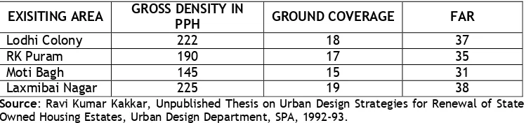
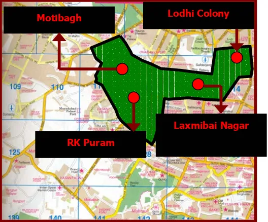
5.4 LOW DENSITY AREAS IN CITY
There is a large proportion of underused land with number of vacant sites or unutilized built areas within the central city. A majority of these are government lands having mostly low density (2 story structures) and old housing. As per the study, government is able to provide housing to only 30-35% of its employees within these areas. The gross densities in these areas are around 160 PPH against 350 PPH in the adjoining areas namely Safdarjang Enclave extn; Munirka; Bhikaji Cama commercial complex. Table 5.5 presents the development profile of low density areas.
Table 5.5: Development Profile of Low Density Area
EXISITING AREA GROSS DENSITY IN
PPH GROUND COVERAGE FAR
Lodhi Colony 222 18 37
RK Puram 190 17 35
Moti Bagh 145 15 31
Laxmibai Nagar 225 19 38
Source: Ravi Kumar Kakkar, Unpublished Thesis on Urban Design Strategies for Renewal of State Owned Housing Estates, Urban Design Department, SPA, 1992-93.
ROHINI RESIDENTIAL AREA
Gurgaon
NH-24
NH-2
NH-1
NH-10
NH-8
HERITAGE PRECINCT
Faridabad
NOIDA
Ghaziabad
NH-1
DWARKA RESIDENTIAL AREA
INSTITUTIONAL AREA WALLED CITY
&ITS EXTN
Client : Dept. of Urban Development, Govt. of Delhi
As per the provision of MPD-2001, the gross density of residential areas should be 350 PPH or 78 DU/ha with FAR of 33% against the existing FAR of 15%; whereas in commercial areas ground coverage of 25% and FAR of 100% is permitted. MPD-2001 & 2021 have recommended comprehensive planning for improvement and redevelopment of these areas in order to make the best use of land resources (Refer Figure 5.3).
Figure 5.3 : Low Density areas in Delhi
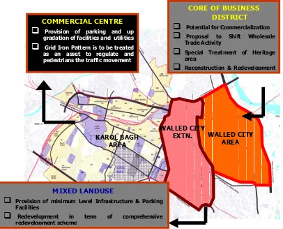
5.5 STATUS OF SPECIAL AREAS
The special area has been divided into three parts namely (i) Walled City; (ii)
Walled City Extension and (iii) Karol Bagh. These are characterized by a mix of different land uses and have similarities in compact built form, narrow circulation space and low rise high density developments mainly accommodating residential, commercial (both retail or wholesale) and industrial uses. Therefore it is important that these areas, which are already established with identified uses, continue to play an active economic role (Refer Figure 5.4).
(a) Walled City Area: The traditional walled city area is a core of the business district. The area is prone to commercialization, particularly with improved accessibility due to the MRTS. Around 20% of the wholesale trade enterprises (37000 enterprises) of urban Delhi are located in the walled city accounting for 12% of the employment.
(b) Walled City Extension: Pahar Ganj, Sadar Bazar, Rosanna Road and their adjoining areas are called as walled city extension. These are old congested built-up areas mainly with mixed land use. For upgradation of the environment in these areas minimum level of infrastructure and parking are to be provided.
(c) Karol Bagh Area: Karol Bagh area has been one of the important commercial centres outside the walled city. The land use transformation
Lodhi Colony
Laxmibai Nagar
Client : Dept. of Urban Development, Govt. of Delhi
from residential to commercial has led to increase in parking demand, reduction in available road width and pressure on other physical infrastructure. Therefore, this area is due for comprehensive redevelopment on the basis of mixed use concept with provision of parking and up gradation of facilities and utilities. The grid iron pattern is an asset to regulate and pedestrianise traffic movement.
Figure 5.4: Status of Special Area of Delhi
5.6 UNAUTHORIZED & UNORGANIZED COLONIES
The unplanned areas of the city include Slum and JJ Clusters, Resettlement colonies, unauthorized colonies and urban villages. Slum and JJ clusters have been discussed in detail in chapter 6. The section below presents in detail the status of unauthorized colonies and urban villages.
Unauthorized Colonies
The large scale land acquisition by DDA, unregulated growth of urban fringes and housing shortage are the genesis of unauthorized colonies in Delhi. There
are around 1432 unauthorized colonies1 providing shelter to around 30 lakh
people. In the past unauthorized colonies have being regularized only twice in
•
1 Though an official figure suggests that 1432 such colonies exist in Delhi, there are at least 200 more such colonies
which sprung up after March 2002 for which no policy exists.
WALLED CITY AREA WALLED CITY
EXTN.
COMMERCIAL CENTRE
Provision of parking and up gradation of facilities and utilities
Grid Iron Pattern is to be treatedas an asset to regulate and pedestrians the traffic movement
KAROL BAGH AREA
CORE OF BUSINESS DISTRICT
Potential for Commercialization
Proposal to Shift WholesaleTrade Activity
Special Treatment of Heritage area
Reconstruction & RedevelopmentMIXED LANDUSE
Provision of minimum Level Infrastructure & Parking Facilities
Redevelopment in term of comprehensiveClient : Dept. of Urban Development, Govt. of Delhi
Delhi. Once in 1961 when over 100 colonies were regularized and last time in 1977 when around 600 colonies where regularized.
Affluent unauthorized colonies included Sanik Farm; Anant Ram Dairy (near RK Puram), Mahendru Enclave (near Model town); other colonies include Zakirnagar, Jamianagar, Anand Parbat, Khanpur Extension, Viswas Nagar, Bawana, Madanpur Khader etc (Figure 5.4). Around 1000 unauthorized colonies are on private land developed by builders.
The infrastructure status in these colonies is marginally better than slums. No metalled road exists in any of these colonies, nor is there a provision of sewer lines and other facilities.
Urban Development Department, NCTD has been putting up various models for regularizing these against the resident’s demand of regularization without any charges (on the line of earlier regularization in 1977). The UDD proposals are presented in Table 5..
Table 5.6: Unauthorized Colonies Regularization Model
Facilities Charges (Rs per m2)
Power Rs 6600 Per KV
Water Rs 220 per m2
Sewerage Rs 355 per m2
Roads and
Drains Rs 400 per m 2
Total Fixed
Charge Rs 1060 per m 2
The cost for regularization of 100 sqm of plot is Rs 1 lakh. Delhi Government had invited application from residents associations for all unauthorized colonies in October 2004, through a public notice. The applicants were asked to submit their area plans. 1153 applications were received out of 1432 unauthorized colonies.
5.7 URBAN VILLAGES
165 urban villages and 52 census towns form part of the National Capital Territory of Delhi (NCTD). These urban villages have undergone significant physical and functional transformation related to their specific location. Villages are characterized by a mix of different land uses and have similarities in compact built-up form, narrow circulation space and high density developments. These mainly accommodate residential, commercial, industrial and mixed uses. These areas, established with identified uses, continue to play an active economic role.
5.8 STATUS OF SHELTER IN CITY
Client : Dept. of Urban Development, Govt. of Delhi
Table 5.7: Housing to be built (1981-91)
Year New Housing required Average per year
1981-86 323000 65000
1986-91 379000 76000
1991-96 434000 87000
1996-01 483000 97000
Total 1619000 81000
Source: A People’s Housing Policy; The case study of Delhi, Hazards Centre, January, 2003
As against this, Table 5. indicates the actual housing development in Delhi until 1995. This indicates that for the period of the second Master Plan (1981-2001), in fact DDA was able to provide land and housing for only 34 per cent of target.
DDA and cooperatives (42.5%) met their share of 43% and the site & services plots resettlement sites (23.9%) correspond to the 25%, but the allotment of plots for individual families (31.7%) significantly exceeded the 17% provision.
Table 5.8: Development of Housing
Type upto 1971 1971-81 1981-91 1991-95 Total %age
DDA Flats 5600 60000 129000 57000 251600 23.5
DUs on individual
plots 59000 82400 135600 63000 340000 31.7 DUs by
Co-operatives - 94661 72960 36000 203621 19.0 Resettlement
Schemes 35000 162700 40000 18300 256000 23.9
Slum Rehousing 9500 6000 4500 - 20000 1.9
Total 109100 405761 382060 174300 107122 100.0
DUs per Year 10910 40576 38206 43575 31506 Source: A People’s Housing Policy; The case study of Delhi, Hazards Centre, January, 2003
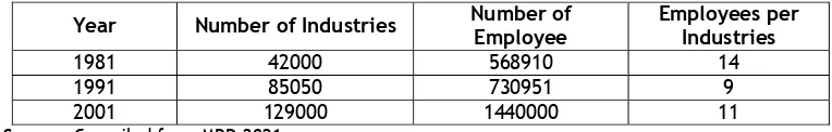
5.9 STATUS OF INDUSTRIAL DEVELOPMENT
As per economic survey of Delhi 2001-02, there were about 1,29,000 industrial units in Delhi in 1998, against 85050 units in 1991. An average unit employed 9 workers while 30% of units employed less than 4 workers. Units related to textiles products constitute the largest number followed by repair services and electrical machinery. Table 5.9 shows the growth of industrial units and employment.
Table 5.9: Growth of Industrial Units and Employment
Year Number of Industries Number of Employee
Employees per Industries
Client : Dept. of Urban Development, Govt. of Delhi
i) Existing Planned Industrial Areas: Out of 1.3 lakhs industrial units in Delhi, only around 25000-30,000 are located in planned industrial areas (Refer Figure 5.5 & 5.6). The existing industrial estates are Bawana; Narela; Badali; Mangolpuri; Okhla; Patparganj and Shahdara. These industrial areas were developed in the 70s and over the years have deteriorated considerably in terms of physical infrastructure. The industrial estates in the city are owned by three agencies- Delhi State Industrial Development Corporation (DSIDC), Delhi Government Industries Department and DDA. These industrial estates have various problems such as pot-holed roads, overflowing garbage bins, lack of water supply, improper electricity installations and absence of banks, common facility centres and post office. All the 28 industrial estates are plagued with the following problems.
• Poor Water Supply: Water is supplied in these industrial estates for less than half hour per day leading to diminishing quality of the produce.
• Bad Roads: The poor road connectivity to industrial estates has made industries withdraw from the area, leading to low occupancy and poor cost recovery. Bawana industrial estate is spread over 1900 acres of land but only around 10 per cent plots are occupied.
• Garbage Disposal: Garbage is littered on the roads and overflows out of the dustbins. The collection system is unreliable.
• Freehold Issue: There is a duality in the policy of the centre and the state. While DDA gives plot on freehold basis, the Delhi government still has a leasehold policy which does not give full ownership of land to the unit owner.
• Encroachment: Several plots are encroached by slum dwellers. The estate manager does not have the power to evict these encroachers.
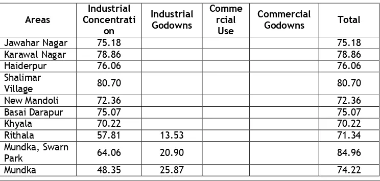
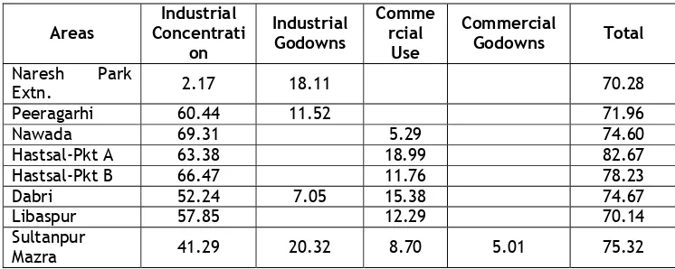
ii) Unplanned Industrial Area: A survey of residential areas with industrial concentration has revealed that only seven qualify clearly for regularization (as per the criteria of more than 70% industrial use). The remaining can get regularized only after considering godowns, commercial shops and commercial godowns as industrial activity (Refer Table 5.10)
Table 5.10: Percentage breakup of Unregularised Industrial Areas in Delhi
Areas
Industrial Concentrati
on
Industrial Godowns
Comme rcial
Use
Commercial
Godowns Total
Jawahar Nagar 75.18 75.18
Karawal Nagar 78.86 78.86
Haiderpur 76.06 76.06 Shalimar
Village 80.70 80.70
New Mandoli 72.36 72.36
Basai Darapur 75.07 75.07
Khyala 70.22 70.22
Rithala 57.81 13.53 71.34
Mundka, Swarn
Park 64.06 20.90 84.96
Client : Dept. of Urban Development, Govt. of Delhi Areas
Industrial Concentrati
on
Industrial Godowns
Comme rcial
Use
Commercial
Godowns Total
Naresh Park
Extn. 2.17 18.11 70.28
Peeragarhi 60.44 11.52 71.96
Nawada 69.31 5.29 74.60
Hastsal-Pkt A 63.38 18.99 82.67
Hastsal-Pkt B 66.47 11.76 78.23
Dabri 52.24 7.05 15.38 74.67
Libaspur 57.85 12.29 70.14
Sultanpur
Mazra 41.29 20.32 8.70 5.01 75.32
As per the Table above the maximum industrial concentration is in Shalimar village which has 80.70 per cent of the area under industries. Areas that do not qualify even after the inclusion of godowns include Tikri Kalan, Prahladpur, Viswas Nagar, Tri Nagar and Nangli Sakrawati. Two areas have more than 85 per cent industrial concentration (GT Karnal Road-80.64% and Kirti Nagar-95.83%) but do not qualify because the land area is less than four hectare land (Refer Figure 5.5)
Client : Dept. of Urban Development, Govt. of Delhi
5.10 ECOLOGICALLY SENSITIVE AREAS
Besides Delhi’s magnificent built heritage (discussed in detail in Chapter 7), there are natural and historical landscape features (Yamuna River Corridor, Delhi Ridge) and the associated protected areas of natural wildlife (Jasola Wildlife Sanctuary) that characterize the urban form of Delhi. The detail status of Yamuna River Corridor and Jasola Wildlife Sanctuary & Delhi Ridge are discussed below.
Areas Characteristics of Ecologically Sensitive areas YAMMUNA
RIVER CORRIDOR
The river front in Delhi has lost its potential heritage, religious, pulic amenity and recreational value. It is surrounded by unplanned and haphazard development of villages and JJ clusters in North; by Thermal Power Plants, Aksardham Temple complex, Commonwealth Game village etc in central part; in the south by Julenagaon; Taimur Nagar, Kalindikunj etc. The problem areas associated with river corridor in NCTD are listed below:
• Though an interstate water sharing treaty exists, there is lack of an effective inter state river basin hydro-policy regime. This results in upstream pollution from agricultural pesticides and sub-optimal water extraction practices.
• The presence of extensive, high density areas of informal low income housing generating large volumes of untreated sewage and solid waste that is discharged into the river.
• A recent Supreme Court Order stipulates that industrial effluent must be treated to a prescribed standard before being discharged into the Yamuna. Making this order operational, through effective implementation, enforcement and monitoring will be critical to the environmental sustainability of the Yamuna.
• Within the context of the Yamuna Action Plan, DDA has proposed to change the use of 260 hectare of land in the central tranche to public use.
JASOLA WILDLIFE AREA AND THE RIDGE
The sustainability of the sensitive ecological habitat of the Jasola wildlife area will also require the formulation and implementation of a special case integrated area strategy that would be likely to include Delhi Ridge as the environmental context and buffer zone to the sanctuary. The problems associated with this area are as follows:
• Temporary incompatible use permissions granted for storage, assembly, temporary accommodation (e.g. exhibition related activities) have left behind residual materials. This despoils the area and renders it environmentally vulnerable.
• Incremental quarry extraction activities have scared the ridge; and (post working) designation as wasteland by the DDA in its land-use plans has consolidated this abuse.
It is imperative to state that the development of Delhi Ridge and Yamuna City Regional Park System has to be comprehensively looked into to plan for better physical environment & ecological system of the city.
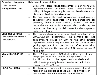
5.11 LAND DEVELOPMENT AND MANAGEMENT
Client : Dept. of Urban Development, Govt. of Delhi
Department/Agency Roles and Responsibilities Land Record
Management, DDA
• Deals with Nazul-I lands transferred to DDA from Delhi Improvement Trust and Nazul-II lands acquired under the policy of large scale acquisition for development and disposal of land by DDA after 1957.
• The functions of the land management department are to acquire land, allot sites for petrol pumps and gas godowns, maintain land records, protect land from encroachment and enforce Master plan section against misuse. DDA has setup six field zones for the purpose of protection of land.
Land and Building Department/Revenue Department
• The revenue department acquires land on behalf of the DDA/MCD/Slum department. The demand for land acquisition is placed by DDA to the land building department, which acquires the land for the DDA after getting approval from the LG; and after acquisition, places the same at the disposal of DDA, under section 12 of DDA act
L&E Department of MCD
• The L&E department of MCD deals with records of land and properties of the colonies/villages within the jurisdiction of MCD. The department also deals with collection of property tax and monitors its activities through the 12 MCD zones.
L&DO GoI, UDPA • The department deals with the maintenance of land record of the properties of the GoI. The activities of construction and maintenance are with CPWD.
In NCTD area most of the lands are owned by the DDA, L&DO and central governments. Land under state ownership is limited and sectorally owned. Agricultural land is mainly privately owned and owners pay agriculture tax to the revenue department. However the private sector primarily comprises of individuals; families; trusts; institutions; families; trusts; institutions and firms/companies, which own or seek land or space built on land (refer Table 5.).
Table 5.11: Land Ownership in Delhi
Land Owning
Railways etc) Total Area in hectare 25377.2 4270.0 114352.8 4300.0 148300
% to Total 17.1 2.9 2.9 77.1 100
Source: DUEIIP, Status Report for Delhi-21
5.12 EFFORTS OF PLANNED DEVELOPMENT
Client : Dept. of Urban Development, Govt. of Delhi
perspective of 2021 prepared in 2005. The salient features of these plans are discussed in the subsequent section.
5.12.1 Master Plan for Delhi (1961-81)
MPD-1981 has divided city into 8 planning divisions and planning districts with an objective to make these self contained in employment and community facilities. As per MPD-1981, these divisions were proposed to have populations ranging from 3 to 7 lakhs. Hence each division had 2-3 district centres, which are composite retail shopping centres with commercial and service uses. As per
the plan, total land available for urbanization in 1981, was about 440 km2.
Beyond this has the “Agricultural Green Belt” which was to be preserved for agricultural use. The proposed activities as per Master Plan (1961-81) are presented in Table 5.12 & Figure 5.7.
Table 5.12: Proposed Activities as per Master Plan (1961-81)
Land Uses Activities
Acquisition of Land and Development
• In order to contain the likely population of about 6.0 million by 1981, the following additional land areas were proposed to be developed under various uses: Residential: 30,000 acres; Commercial: 1900 acres; Industrial: 4800 acres; Government: 500 acres; Recreational: 25000 acres
Residential • Medium and High Density residential development proposed in the planning division A & B (Old Wall City area & its Extension).
• Average Residential Density ranges from 81 PPA in West Yamuna Canal area to 235 PPA in old walled city area. The average gross density in the Master Plan is about 97 PPA.
• Redensification of low density areas such as Lodhi colony; RK Puram, Motibagh and laxmibai nagar.
• Developing Low income housing-1,50,000 units; government housing-1,10,000 units and private housing-4,85,000 units
Commercial • The Commercial area as per MPD 1981 works out to be 0.48 acres/1000 population.
• The hierarchies of commercial area proposed were Central Business District (CBD); District Shopping Centre; Community Shopping; local shopping and convenient shopping.
• Development of commercial area of 565 acres. Slum
Improvements &
Redevelopment
• 20 projects were to be developed upto 1981 for slum improvements. These slum areas are Kotla Mubarakpur; Sui Walan; Kucha Pati Ram; Sarai Rohilla; Qadam Sharif; Shadipur Khampur, Ajmeri Gate etc.
Industrial Area • Areas proposed for industrial development. The details are given as part of Table 5..
Recreational Areas
• It has been proposed to develop 25000 acres of land for recreational use.
• It was proposed to provide active recreational facilities such as open air theatres, libraries, museums, swimming pools, terraced gardens, landscaped vistas and botanical gardens.
Plan for Rural Delhi
• The rural towns proposed for the location of light and medium industries are Nangloi Jat, Bawana, Palam and Najafgarh
• It was proposed to provide 17 local shopping centres for each cluster of villages (within radius of 3 miles from every village), 6 district shopping centres for bigger village groups (within radius of 5 miles from every village) and 3 mandis in more central location (Palam; Khera kalan and Kanjhawala).
Client : Dept. of Urban Development, Govt. of Delhi
Table 5.13: Proposed Wholesale & Specialized Markets (1981)
Market Proposed Location Area in
Acre Fruit and Vegetable
Markets
One mandi near Daya Basti railway station in Sarai Rohilla in North-west and another in South of Delhi at Okhla
35
Wholesale Grain Market Site near Teliwara, in north of Sadar bazaar was proposed
17
Bicycle and accessories Jhandewalan area 10 Cloth Market Redevelopment & Modernization of Chandni
Chowk area and site west of church mission road
10
Fodder Market Dayabasti near Najafgarh Road 6
General Merchandise and hosiery
Improvement and reorganization of Sadar Bazar-Old Bahadurgarh road
61
Iron, steel and scrap metal market
Jhadewalan; reorganization of junk & scrap yards in Motia Khan
15
Building Materials West Delhi adjacent to the railway line to Rewari
50
Source: Compiled from Master Plan of Delhi-1961-81
Table 5.14: Proposed Location of Industrial Estates and Zones (1981)
Industrial Area Total Land (in acres)
Industrial Area Total Land A. Extensive manufacturing B. Intensive Manufacturing C. Service
Industries
355
Najafgarh Industrial Area
716 Flatted industries inlying locations
1241 Flatted industries outlying locations
Source: Compiled from Master Plan of Delhi-1961-81
5.12.2 Review of Master Plan Proposals
Client : Dept. of Urban Development, Govt. of Delhi
Transport at ion Facilit ies
25% Agricult ure
16.2%
Figure 5.6: Proposed Landuse 1981 Figure 5.6(a): Existing Landuse 1961
Other departures from the proposed master plan measures include:
• As proposed the enhancement of existing CBD in MPD-81 did not take place.
Connaught place & its extension and commercial areas in the walled city and its extension continues to function as CBD with all the associated problems of parking and traffic congestion etcl.
• As per MPD-81, all non-conforming uses were to be shifted in stages to
conforming areas; but no areas with non confirming uses were shifted out.
• MPD-81 proposed industrial areas consisting mainly of flatted factories; light
industries and extensive industries but no flatted factory area was developed except for Jhandewalan area.
• MPD-81 estimated around 20000 informal sector units in 1981 which is
limited to 15%. Moreover plan did not contain any specific proposal for integration of unorganized sector in development schemes.
• MPD-81 targeted to construct government housing, Low cost housing and
private housing as per details mentioned in Table 5.11. During the two decades, only 5.43 lakhs houses had been constructed against target of 7.47 lakh.
• MPD-81 had proposed 15 district centres out of which only 3 had been
developed in 1981 (Nehru Place; Rajendra Place and Bhikaji Cama Place.
• Two wholesale markets namely Fruit & Vegetable Market (Okhla) and Iron &
Steel Market (Jhandewalan) had been shifted out up to 1981; and two cycle & truck accessories markets were partially shifted. Most of the other markets continued to grow further in the walled city creating, further congestion.
5.12.3 Master Plan for Delhi (1981-01)
MPD-2001, was based on the basic premise of Balanced Regional Development, which emphasizes restrictive policy of employment generation. The main guidelines for this policy were: (i) only such new Central Government Offices which directly serve the Ministries of the Government of India be located in Delhi; (ii) Industrial Growth in Delhi be restricted to small scale and less labour intensive and (iii) Legal & Fiscal measures to restrict employment and distributive trade.
Proposed 1981
Client : Dept. of Urban Development, Govt. of Delhi
The MPD-2001 projected a population of 12.8 million by 2001 for the entire NCT. However, the plan recommended to restrict the population to 11 million in NCT and divert the remaining 0.2 million to selected towns in the NCR. The population of NCT was however 13.4 million in 2001 Refer Figure 5.8.
(i) Spatial Strategies
The Master plan has come up with strategies for each of the constituents of the NCTD and DMA area. The proposed strategies as per Master Plan (1981-01) are presented in Table 5.15.
Table 5.15: Proposed Activities as per Master Plan (1981-01)
Constituent
Area Proposed Strategy
Acquisition of Land and Development
• 24000 hectare of land to be acquired up to 2001
• Land development for residential purpose 12000 ha and industrial purpose 1600 ha
Walled City-Special Area
• Revitalization of Walled City keeping in view the traditional character and style of the buildings
• Redevelopment of Sadar Bazaar wholesale market by provision of necessary infrastructure and parking areas
• Prohibiting all heavy commercial vehicles in walled city area
• Cars not allowed inside the walled city areas with provision of underground parking at Lal Quila, Delhi Gate, Ajmeri Gate, Turkman Gate, Mori Gate and Purdah bagh
• One way traffic on all the streets of walled city
• Planning tools such as conservative surgery to be adopted for city upgradation
Residential
• New Concept of Partially built plotted housing has been introduced. This involves partially built housing on individual plots of 70-80m2.
• Cooperative formation in 600 unauthorized colonies for improvement of low level of physical & social infrastructure
• Planned Development of Urban extension areas (Rohini, Dwarka and Narela)
• Augmentation of housing at focused locations-Patparganj, Sarita Vihar and Vasant Kunj (4000 ha)
Commercial
• Existing CBDs-Old Wall City, Connaught Place and Karol Bagh two Sub CBDs, Proposed 2 Sub-CBDs (One in Trans Yamuna Area & other in the urban extension area)
• Existing Five district centers; 22 new district centers proposed (14 in existing urban limits & 8 in the urban extensions)
• It was proposed to develop four regional wholesale markets in different directions integrated with freight complexes.
• 11 regional cum local wholesale markets as secondary wholesale markets are proposed to be developed in different planning divisions.
Slum
Improvement & Redevelopment
• Provision of Hostel accommodation for single; minimum 25% as site and Services and 45% housing up to 2 rooms dwellings for about 1 lakh LIG families
• Infrastructure up gradation in 44 resettlement colonies and provisions of income earning opportunities within or proximity of resettlement colonies
• Provision of slum housing for 49000 families
Client : Dept. of Urban Development, Govt. of Delhi Constituent
Area Proposed Strategy
Industrial Area); Shahdara (Light Industrial Area) and Shampur Badli (Extensive Industrial Area)
• Provision of 16 new light industrial areas (Total area of 1533 ha) was to be developed in urban industrial extensions (UIE). Each UIE upto 5 units of about 20 ha.
Recreational Area
• Provision of 1.6 km wide green belt beyond urbanisable limits
• Provision of Divisional sport centres-7nos; District level children parks-11nos; Development of lakes-2nos
Plan for Rural Delhi
• Five villages were identified as higher order growth centre-Bakhtwarpur; Bawana; Jharoda Kalan; Dhansa and Chawala. Six villages were identified as lower order growth centre- Jagatpur; Ghogha; Qutab Garh; Jaunti; Mitron; Gommanhera
• Environment improvement of 120 villages and development of 11 central villages
Channelisation of River Yamuna
• Development of river front considering all ecological and scientific aspects as project of special significance for city
Table 5.16: Proposed Wholesale & Specialized Markets (2001)
Market Proposed Location Area in
Hectare
A. MARKET WITH WAREHOUSING
Textile & Textile Products
Patparganj in east; Madanpur Khadar & Urban Extension in South; Urban Extension in South West 70 Auto, Motor
Part & Machinery
Patparganj in east; Urban Extension in South; Urban
Extension in South West 43
Fruit and Vegetable
Market
Loni Road in east; Madanpur Khader & Urban Extension
in South; Urban Extension in South West 53
Hardware and Building
Material
Patparganj & Loni Road in east; Madanpur Khader & Urban Extension in South; Urban Extension in South West
53
Iron and Steel Patparganj in east; Madanpur Khader & Urban Extension in South; Urban Extension in South West 25
Food Grain Patparganj in east; Madanpur Khader in South; Nazafgarh in South West 32
Timber
Patparganj & Loni Road in east; Madanpur Khader & Urban Extension in South; Urban Extension in South West
112
Plastic Leather
and PVC Patparganj in east and Urban Extension in South West 19 Relocation of
Junk Market Patparganj in east 4
Truck Terminal
Patparganj in east; Madanpur Khader & Urban Extension in South; Najafgarh & Urban Extension in South West
219
Regional cum local Markets
Sub-CBD (Shahdara); Okhla; Rohtak Road District Centre; Shivaji Place District Centre in North; Wazirpur District Centre; Rohini District Centre; Markets of 8-10hectare in each urban extension and fodder markets was to be developed in the rural areas
Client : Dept. of Urban Development, Govt. of Delhi
Market Proposed Location Area in
Hectare Integrated
Freight Complex
Madanpur Khadar (NH-2); Patparganj (NH-24); GT Road (NH-1) and Bharthal (NH-8) - Source: Compiled from Master Plan of Delhi-1981-01
• Review of Master Plan Proposals (1981-01)
Proposals which have not been completed as per the directions of the Master Plan are presented below:
o As proposed the enhancement of existing CBD in MPD-01 did not take place.
Connaught place & its extension, and commercial areas in the walled city and its extension continue to function as CBD with all the associated problem of parking and traffic congestion etc.
o District centres at Jhanakpuri; Laxminagar and Shivaji palace are still in
process of development
o As per MPD-01, all non-conforming uses were to be shifted in stages to the
conforming areas but no areas with non-conforming uses were shifted out.
o No provision of Hostel accommodation for single workers; or minimum 25%
as site and Services and 45% housing up to 2 rooms dwellings for about 1 lakh LIG families were made up to 2001
o Only 1 integrated freight complex at Gazipur is in development stage
against the 4 proposed in MPD-01.
5.12.4 Draft Master Plan for Delhi (2001-21)
The land use plan 2021 has been prepared based on (i) the policies enunciated for different urban activities; (ii) requirement of additional social and physical infrastructure; (iii) Transportation and work centres; (iv) restructuring of land uses along the MRTS corridors. In order to control development; the areas have been designated as one of the 27 use zones. These zones have been classified
into 10 categories2 as shown in Figure 5.9.
MPD-2021 projected a population of 23.0 million by 2021 for the entire NCT. However, the plan recommended accommodating 11.4 million people in zone A to H; and 3.9 million in Dwarka, Rohini phase-III, IV & V and Narela; and diverting the remaining 8.0 million in the planned new urban extensions. MPD-2021 is in draft stage the detailed provisions and development strategy suggested in the plan will be presented once it is finalized.
5.13 PROVISIONS OF NCR PLAN 2001 & 21
Five towns were proposed in the Master Plan (2001-21) as DMA towns in the Delhi Metropolitan Area (DMA). These include Ghaziabad, Faridabad, Gurgaon, Kundli and Loni. A total of 3.5-lakh population was assigned by the Master Plan to these towns for the year 2011. Besides, specialized economic activities were
•
2 The Landuse categories are Residential; Commercial; Industrial; Recreational; Regional Park/Ridge; Transportation;
Client : Dept. of Urban Development, Govt. of Delhi
proposed for each of these towns. A brief summary of the land use allocation strategies and provisions in NCR plan is discussed below:
Sectors Recommendations Development of
New Townships
• DMA Towns: Faridbad, NOIDA, Ghaziabad, Kundli, Bahadurgarh and Gurgaon
• Priorty Towns (Regional Centres): Palwal, Khurja, Hapur, Meerut, Bulandshar, Panipat, Rohtak, Dharuhera, Bhiwadi, Rewari, Alwar
• Counter Magnet Towns; Patiala (Punjab); Bareilly (Uttar Pradesh); Gwalior (Madhya Pradesh), Kota (Rajasthan), Hissar (Haryana)
• Sub- Regional Centre: Shikarpur; Philhua; Tijara; Khairthal; Bahror; Bawal; Hathin; Hodal; Jhajjar and Sonipat
Development of Transport Sector
• Development Proposals: Regional Road Links
• Elevated Expressway on Ring Road
• Development Proposal-Regional Rail Industrial
Development
• Industrial Development through NCRPB assistance in Loni; Faridabad; Kundli; Gurgaon; Meerut; Barhi; Panipat; Manesar; Bhiwadi; Bawal; Neemrana; Alwar
5.14 ISSUES IN LAND & GROWTH MANAGEMENT
Some of the major issues emerge from the above analysis are presented below:
• Increasing gap between demand and supply of housing and infrastructure: The growth of unauthorized colonies and JJ clusters clearly indicate the housing status of the city. Consistently, targets for housing provision have not been met. Moreover, the poor have borne the brount of the shortfall. Overall, Around 5 lakh houses are to be constructed to fulfill past back logs, over and above the future demand of 20 lakh houses by 2021.
• Over crowding, haphazard development without basic services: There are 728 JJ clusters; 1700 unauthorized colonies and 165 urban villages accommodating around 60 lakh population. Of these, barely 25% of the population has access to physical infrastructure.
• Encroachments on agricultural land and urban villages: The urbanization area is expanding in an adhoc manner, often into the green area. Due to lax development regulations and control, rural areas are falling prey to unauthorized development. Original land owners have parceled their holdings and sold these at high prices to builders/developers. Urban villages have been over-run with haphazard developments
• Exploitation of Land for unauthorized development: Large portion of urban land in NCT is owned by government generally for public, community and government uses. Without programmed use and efforts for protection, these lands get easily encroached by both marginal groups and unregistered land speculators. This is further aggravated by insufficient official provision of land for various uses – be it residential, commercial or industrial.
Client : Dept. of Urban Development, Govt. of Delhi
inaccessibility to work-centre of the relocation site; lack of infrastructure; security of tenure & assets and affordability of the owner.
• Lack of Linkage of Physical Planning Strategy with Financial Planning:
Successful physical planning should respond to economic realities; and support broader financial goals and strategies for the city. The link between these aspects, while strong in the first Master Plan, seems to have weakened substantially in subsequent plans. Failure of implementation has aggravated the situation further.
Client : Dept. of Urban Development, Govt. of Delhi
Figure 5.8 : L A N D U S E M A P 1981 - 2001