Participatory
Monitoring
and
Assessment
of
Ecosystem
:
Lessons
Learned
for
Development
SummaryoftheNationalConference
KasetsartUniversity,Bangkok
26Ͳ27May2005
Editedby
SomyingSoontornwong
RaweeThaworn
AttjalaRoongwong
MatthewWeatherby
Ecosystem: Lessons Learned for Development
Summary of the National Conference during 26-27 May 2005, at Kasetsart University, Bangkok
October 2007
Editorial Team:
Somying Soontornwong, Rawee Thaworn, Attjala Roongwong, Matthew Weatherby
Artwork:
Kanokwan Homcha-aim
Cover Design:
Do My Best Limited
4/349 Mu 3 Paholyothin Rd. khlongluang Pathumthani 12120
Printing:
Benchaphon Co., LTD.
2229/26 Ramkhamhaeng Rd. Huamark Bangkapi Bangkok 10240
Published by:
Thailand Collaborative Country Support Program
Regional Community Forestry Training Center (RECOFTC) PO Box 1111 Kasetsart University
Bangkok 10903, Thailand
Tel: (66-2) 940-5700 ext. 1208, 1237 Fax: (66-2) 562-0960 Email: [email protected]
Supported by:
Introduction 1
The conference 2
x Aims 2
x Lessons learned: natural resource 3 and forest monitoring in Thailand
x The way forward in participatory 6 monitoring approach for forest and other natural ecosystems in Thailand
x Concluding remarks 10
Progress in Ecosystem Monitoring in Thailand 11
x Evolution of community-based ecosystem 11
monitoring in Thailand
x National forest monitoring in Thailand 12
x Progress in Thailand 13
Participatory Forest Management Monitoring: 26
Case studies from Thailand Collaborative Country Support Program (ThCCSP)
x Case study 1 : Monitoring of sustainable 27 management of monastery bamboo forests: Khao Rao Thian Thong community forest,
Mueang district, Trat province
x Case study 3 : Monitoring of Melientha suavis 45 (phak wan) for sustainable management:
Rom Pho Thong community forest, Tha Takiap district, Chachoengsaoprovince
x Case Study 4 : Monitoring of sustainable 54 use of timber and bamboo products:
Huai Hin Dam community forest, Dan Chang district, Suphanburi province
x Case study 5 : Monitoring of forest for 62 poverty alleviation at Mae Tha sub-district
community forest, Mae On branch district,
Chiang Mai province
x Case study 6 : Seep management and 69 monitoring: Sam Pak Nam community forest,
Chumphae district, Khon Kaen province.
---INTRODUCTION
In the kingdom of Thailand, forest ecosystems play a pivotal role in the livelihoods of both rural and urban communities. Rural communities depend upon the forest as a source of food, shelter and income, whereas urban communities rely on forests to sustain the hydrological cycle and as a venue for recreational activities.
Ascertaining the correct balance between utilizing the goods and services that forests can provide in conjunction with sustainable management practices and biodiversity conservation is a highly important and debated topic within Thailand. In recent years there has been a greater societal interest in the sustainable management of forests and their natural resources and this has gradually seen the inclusion of local communities in the forest decision-making processes.
THE CONFERENCE
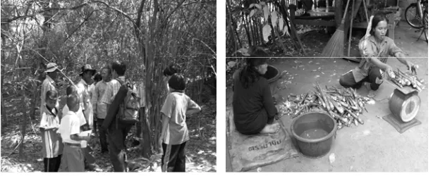
On 26 and 27 May 2005, more than 200 participants attended the “Participatory Monitoring and Assessment of Ecosystems: lessons learned in Thailand” national conference held at Kasetsart University, Bangkok. The attendees comprised: government officials, education and research staff, non-government organization (NGO) workers, community representatives and the media.
Figure 1 - 2 National technical conference on the participatory monitoring and assessment of ecosystems
Aims
(CBEM). This is a form of participatory monitoring that provides community members and NGOs the opportunity to work together in monitoring selected plants, wildlife, habitats and ecosystems. In this case, active community participation and stakeholder collaboration can lead to the development of indicators and data collection methods that are workable and accepted by local communities.
Lessons learned: natural resource and forest
monitoring in Thailand
Since the introduction of the national logging ban by the Thailand government in 1989, there has been considerable debate and attention provided to the possibility of allowing community management of forest areas in Thailand. Ongoing awareness of community forestry (CF) in the past decade has led to a significant increase in research activity and the development of indicators that may support CF in Thailand.
Early indicators for CF were constructed with a focus on measurement of resources and their abundance within the forest areas. Concurrently, forest dependent communities had also begun monitoring natural resources within their local areas. This led to some collaboration with a variety of organizations and the adoption of a number of approaches like environmental education and local culture based research. A few case study examples of these approaches that were presented at the conference include:
x River ecosystem monitoring of the Ping river in Chiang Mai;
x Lee watershed monitoring in Lamphun province; x Nan river monitoring by civil society groups in Nan
x Songkhla lake ecosystem monitoring;
x Wetland forest monitoring in Sisaket province; and x Thung Maha mangrove monitoring in Chumphon
province.
Further, many communities have been monitoring keystone species and resources that are of importance to their communities, particularly:
x Grapsoid crab monitoring at Pred Nai mangrove community in Trat province;
x Bamboo shoot monitoring in Khao Rao Thian Tong in Chai Nat province; and
x Opliaceae monitoring at Ban Rom Pho Thong in Chachoengsao province.
At the national level, natural resource and environment monitoring systems were developed consisting of criteria and indicators of sustainable development established by the Office of Natural Resource and Environment Policy Planning. The Royal Development Projects Board also developed a framework (often referred to as the Pressure-State-Response framework) for natural resource and environment assessment. This framework is inclusive of terrestrial and marine ecosystems, silvicultural, agricultural and socio-economic criteria and indicators. Satellite imagery was also widely undertaken to assess the ongoing changes that take place within some forest areas.
Ministry of Natural Resources and the Environment has subsequently led to apparent neglect to the Model Forest project. Essentially, there is still a strong requirement for the government to move forward and develop an effective monitoring system for forest management in Thailand.
The 2005 Conference discussed a number of ecosystem monitoring issues that had been conducted by researchers in Thailand over the past decade. In most cases, the research was quite specific rather than being broad-based and applicable to a large number of cases. Further, most research was representative of short-time frames and a small stakeholder base. Evidently, there is the need for the development of monitoring mechanisms at the local and national level in Thailand. This will only be achieved, however, if information sharing becomes paramount and there is strong institutional support.
The way forward in participatory monitoring
approach for forest and other natural
ecosystems in Thailand
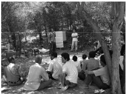
During the 2005 participatory monitoring and assessment conference there were three group discussions focused on three main ecosystem types, namely: 1) community forests, 2) watershed, and 3) mangroves and wetlands. Two small group discussions also focused on research and the role of the media in participatory monitoring. The discussion on the three ecosystem types was summarized under the following headings: ecosystem monitoring framework; methodologies for participatory ecosystem monitoring; and research development for participatory ecosystem monitoring.
1. Ecosystem monitoring framework
The three ecosystem types discussed during the conference were considered to comprise similar monitoring frameworks. These frameworks are apparent at the community and landscape level. There are three common categories of indicators comprising:
1) A set of indicators on resource conditions and ecosystem integrity. For example, at the community level monitoring tends to focus on fringe forest zones and comprise ecological studies, whereas, the study of larger forest areas (e.g. watersheds) tends to take place on an ad-hoc basis (e.g. measurement of water flow).
2) Indicators related to the resource management such as societal values and perceived importance of the resource.
2. Development of methodologies for participatory
ecosystem monitoring
There is a need for a participatory ecosystem monitoring methodology that can be applied at the local level but also can be elaborated at each level of society. For this to occur, cooperation is required from all stakeholders. An appropriate methodology can be developed utilizing existing local knowledge, research and lessons learned. Further development requires the support of local authorities and experts, the Community Forestry Department, water resource management units and the Thailand Research Fund.
Information exchange is critical in developing appropriate methodologies and ensuring they are disseminated via appropriate networks for landscape and watershed management. National forestry groups have a role to play in collecting and collating local community forestry-based monitoring systems in order to facilitate and complement information exchange. Key stakeholders that may assist in the development of these issues are: regional institutes; RECOFTC; forest conservation institutes; provincial natural resource and environment offices; regional education institutes and universities.
At the national level, there is a desperate need for an agency that has a defined mandate for national ecosystem monitoring by linking regional information. It is suggested this agency could function under the auspices of either: the Office of Natural Resource and Environment Policy and Planning; the Royal Forest Department; Department of National Parks Wildlife and Plant Conservation or the Office of the National Parks.
Figure 5 - 6 Small meeting groups brainstorming on participatory monitoring of ecosystems
3. Research development for participatory ecosystem
monitoring
Small scale individual ecosystem issues can be linked in overview to the landscape as a whole by conducting participatory ecosystem monitoring from upstream to downstream. Research should be based on indigenous knowledge. It is paramount that local and scientific knowledge is integrated by collaboration between local communities and experts.
community approaches and knowledge with respect to ecosystem management. Key issues include the development of appropriate technologies and methodologies that integrate, involve, are easily comprehensible and are regarded as meaningful by local communities. This process can be assisted by:
x Knowledge management involving the collection and collation of lessons learned from individuals and documented materials as well as the establishment of networks to pass on this information. RECOFTC has the ability to coordinate knowledge management, establish networks and disseminate information, news and developments in natural resource and ecosystem monitoring.
x Building collaborative research or partnerships at same working sites. There are eight field sites managed by RECOFTC, 80 local research sites for the Thailand Research Fund (TRF) and a very large base for the collection of lessons learned on ecosystem monitoring when taking into account the projects of the Royal Forest Department, National Parks, Wildlife and Plant Conservation Department and those of NGOs.
Concluding remarks
Overall there can be three key points that are considered to be lessons learned about participatory monitoring and assessment in Thailand based on the case studies presented in the conference of 2005. The lessons learned are:
1. A lack of education or a poor social background is not an excuse for prejudice that would prevent the introduction of participatory management approaches.
2. Awareness-raising amongst local people and joint management is essential for participatory management.
PROGRESS IN ECOSYSTEM MONITORING
IN THAILAND
Evolution of community-based ecosystem
monitoring in Thailand
Prior to 1987, forest land in Thailand was managed exclusively by the national government and there was little recognition of the forest management practices of forest dependent communities. However, the introduction of the ban on logging in 1989 led to studies of forest dwellers which provided a better understanding to researchers and officials of their forest management practices. At the same time, many educational institutions began to develop innovative tools and approaches for forest management, such as Rapid Rural Appraisal (RRA), Participatory Rural Appraisal (PRA), Community Forest Appraisal (CFA) and Participatory Action Research (PAR). This created a revolution in community forestry and led to practical application in over 10,000 communities throughout Thailand. Subsequent development of a CF Bill took place (although yet to be passed through Parliament) and by the year 2000, discussions on people and forests, biodiversity conservation and poverty alleviation for forest dependent communities became common public issues.
monitoring and assessment systems that cater for adaptive management practices.
Many communities have developed their own indicators for community forests and have cooperated with experts in the collection and analysis of data. Generally, the assessment of indicators is compiled by establishing village boundaries, forest boundaries and total forest area. Following this, permanent sample plots are developed for evaluating parameters such as the percentage density of bamboo clumps in a given area. In each case, for monitoring to occur on a regular basis, it is dependent upon community participation whether it is voluntary or through a particular interest group.
National forest monitoring in Thailand
The development of criteria and indicators for forest management in Thailand began in earnest in 1998 after Thailand accepted the resolution of the 1st ASEAN Senior Forestry Officials
Conference held in Malaysia that same year. The conference implored ASEAN countries to develop criteria and indicators that will illustrate progress in sustainable forest resource management for each ASEAN country. In Thailand, the Royal Forest Department assumed responsibility for this task and appointed a committee to determine the criteria and indicators necessary for assessing sustainable forest management. The criteria were to serve as national standards with a focal point toward a forest management development group and demonstration forest zones.
indicators and to make amendments where necessary. On 22 June 2000, the committee issued the Thailand National Criteria and Indicators for Sustainable Forest Management comprising seven criteria and 67 indicators (outlined in Table 1).
Table 1: Criteria and indicators for national sustainable forest management
Criteria Number of
Indicators 1 Elements facilitating forest
management
9
2 Forest resource security 7
3 Forest ecosystem status and abundance
9
4 Sustainability of forest yields 8
5 Biodiversity 6
6 Water and Soil 9
7 Economic, social and cultural conditions
19
Progress in Thailand
1. Forest ecosystem restoration monitoring
Box 1 Case study of Mae Sa Mai community: Chiang
Mai Province
(paper presented at the conference by K.Boonsai, S.Sangkam, N.Thanomvorakul, N.Kwamdeedumrong and S.Elliott)The Mae Sa Mai community is located in the Pongyaeng sub-district of Chaing Mai province and is a Hmong ethnic minority village. It is an agricultural community surrounded by the hills of the Mae Sa watershed located within the Doi Sutep-Pui National Park. However, forty years ago the community was located at the top of the hills but later had to migrate to their current location due to ecosystem changes and lack of plentiful fresh water supply.
Originally, Mae Sa Mai community comprised barely eight households and practiced swidden rice and vegetable cultivation on flat areas in the hills and utilized opium as a cash crop. The suppression of addictive drugs imposed by the government and other strict measures imposed for forestry conservation led to the planting of mono-crops such as peach and seasonal vegetables that include carrot, cabbage and potatoes. Today, Mae Sa Mai has almost 2,000 persons living in more than 300 households and mono-crops (especially lychee) as a response to consumer preferences.
Mae Sa Mai has a lengthy history of deforestation in the watershed of Doi Sunthep-Pui National Park which tends to have a direct impact on the quality of life of people in the village, as well as other villages located in the nearby Lae Sa watershed. The direct impacts are typically a reduction of quantity and quality of water flow, increased severity of drought, erosion and a general decline in forest game and forest resources.
brunt of considerable criticism over their livelihood practices. This criticism is often stronger towards villages of this nature given the negative perceptions the government and society in general tends to portray ethnic minorities. In essence, Mae Sa Mai village was regarded as the sole contributor to the environmental problems faced in the Doi Suthep-Pui national park, despite similar practices occurring in nearby villages.
Mae Sa Mai village afforestation
During the early 1990s, a rehabilitation and conservation forest area surrounding Mae Sa Mai village was designated by the village. A natural resource and environment conservation club was formed and plans were drafted and activities implemented soon after for protection of the forest. Rules, regulations and penalties in the form of fines and community service to compensate for infractions were introduced. Soon after, the hunting of fauna was banned and the expansion of areas under cultivation was under control of the conservation club. Overall, the club was initiated to promote restoration of natural resources within the forest area and overseeing the building of shared responsibilities and alliances for the management of the forest.
In 1996, the Mae Sa Mai conservation club requested cooperation and assistance from the Forest Restoration Research Unit (FORRU) of Chiang Mai University for the application of scientific knowledge to the rehabilitation of forest ecosystems in Northern Thailand. The FORRU duly assisted the village by:
x gathering funding for a community nursery;
x the collection of seeds from the surrounding forest and the germination of those seeds;
x management of the nursery and care of the seedlings;
x preparation of reforestation sites;
x reforestation;
x post-reforestation treatment;
x holistic reforestation monitoring.
For the success of the FORRU method in Mae Sa Mai, it was important that the selected species for replanting were indigenous species that are easy to germinate and had high survival rates in this region.
Monitoring forest rehabilitation in Mae Sa Mai village: post-planting Following the replanting that took place in the Mae Sa Mai area, three objectives were developed as part of the plan to monitor and evaluate the success of the replanting scheme. These objectives were:
1. To select relevant species from the list of structural species used in forest rehabilitation in the Northern Thailand region.
2. To test, develop and improve the structural species approach undertaken by the FORRU.
3. To monitor, measure and evaluate the return of biodiversity in the rehabilitated forest area.
Since the time of the initial replanting, there are today many joint activities between Mae Sa Mai community and FORRU. An initiative of FORRU sees local school children measure nearby trees for their height, shape and overall health within the reforested plots. This has not only taught many village children the ability to monitor tree survival and growth rates, but also the importance of monitoring.
The success of the initial replanting combined with education has led to the villagers taking ownership of the community nurseries and conducting their own surveys of a variety of plant species. For example, villagers now conduct fortnightly surveys on the flowering and fruiting of trees planted in previous years and compile this information for monitoring purposes. Further, when the villagers see any wild animals within the replanted areas, this information is recorded and provided to FORRU.
The lessons learned from Mae Sa Mai
been no less than 32 hectares of rehabilitation carried out by the villagers in conjunction with the assistance of FORRU. There is some evidence of the reforested areas joining together with other parts of the forest due to the diligence of management by the villagers. For example, trees that are less than three years old are regularly weeded and fertilized. Furthermore, the villagers often undertake fire watch patrols to prevent and control forest fires and this has seen the number of forest fires in this area decline markedly.
The monitoring of the reforested area has shown that within three years the replanting can lead to a closed forest canopy and the flowering and fruiting of many of those trees. This has naturally seen an increase in bird numbers in the replanted areas. The number of bird species found in reforested plots that were five years or older tended to increase dramatically. For example, bird nests were also found in 17 different species of trees in the five-year old plots and 53 bird species were identified as utilizing the forests for roosting and hunting purposes. Some medium-sized mammals were also found in the rehabilitated plots, including pangolins, Burmese ferret-badgers, civets, barking deer and wild boar.
Essentially, the structural approach applied by FORRU and the local villagers has enabled the rehabilitation of the forest and led to an increase in biodiversity to the forest within just a few years of plantings. Evidently, the number of new tree species that has been generated by the activity of wildlife in the rehabilitated plots has increased two-fold.
Concluding remarks
After eight years of collaboration, most stakeholders have come to recognize that a lack of education or a poor social background is not a barrier to the ability for villagers to learn, understand and apply scientific knowledge and the necessary tools for the effective monitoring and management of the forest. In essence, communities similar to that of Mae Sa Mai should not suffer from discrimination or access to scientific information and expertise due to prejudice based on poor knowledge capabilities of the villagers.
In the past three years, FORRU has undertaken more than 30 training and exposure trips (involving more than 700 participants) to the rehabilitated areas. This is because Mae Sa Mai village is a thriving example that demonstrates as a learning resource the ability for ethnic minority communities to establish forest plots with the aim of forest rehabilitation in a highland evergreen forest ecosystem.
2. Monitoring of streams and water sources
in conjunction with NGOs and Department of Environmental Quality Promotion; Ministry of Natural Resources and Environment.
3. Wetlands Monitoring
Wetlands management and monitoring systems have been developed in many areas of Thailand employing bio-indicators such as fish and aquatic plants, and chemical indicators. Examples of monitoring by bio-indicators include fish monitoring of wetland forests in Ise village, Po Si Suwan branch district, Sisaket province.
Box 2 Case study of Haui Thapthan community,
Sisaket Province
(paper presented at the conference by P.Wonglert)Ise village is located near the Huai Thapthan River in the Po Si Sumwan branch district of Sisaket Province, Thailand. The village is situated in an area of riverine forest that is regarded as one of the most important wetland areas for Northeast Thailand. Most of the communities in this region are depend on rice harvesting and fishing for their livelihood. However, rapid population growth has led to an overall scarcity in the natural resources in this region in recent years.
Chemical-based agriculture is widespread in this region. This has led to a rapid decline in the number of aquatic species in the river due to the lack of understanding of the negative impacts of chemical use in wetland areas. Water contamination is widespread and often the drinking water is hazardous to humans. Furthermore, modern agricultural practices have led to substantial erosion along the waterway.
communities living in the Non Yai forest region and along the banks of the Huai Thapthan River.
Monitoring in Huai Thapthan
Monitoring of Huai Thapthan River first took place in 1997. The initial activity was known as Eating Wild Rice – Wetlands Fishery and took place on a specified day in the dry season during April each year. On the day, villagers would come together and conduct a ceremony to pay respect to the ‘grandfather’ or ancestor spirit to ask permission to catch fish in their indigenous traps. The ceremony and fish gathering was led by the village elders in an effort to unite everyone in the village and all fish that was caught would be distributed equally.
The most important aspect of this annual activity was that villagers were gathering to discuss the conditions of the surrounding forest and wetlands. On the day, specific monitoring and data collection would also be carried out and sampling nets and traps would be placed at three wetland forest zones. The number of fish species captured would then be recorded for future comparison.
The results of the Huai Thapthan River surveys during the period of 2002 to 2004 illustrated the quantity of fish captured had declined markedly. The Non Yai youth club found that modern fish traps, fishing during the breeding season, increased drought severity that reduced river flow into the wetlands and especially the use of chemicals in nearby chilli plantations and rice field pesticides, were each significant contributors to the poor state of the river.
x An annual survey of fish traps and varieties;
x A survey of aquatic plants;
x Survey of the impact of the use of chemicals that negatively affect organisms in the wetlands;
x A clean water project; and
x A project to plant Garcinia and other plant species along the banks of the Huai Thapthan River.
4. Participatory mangrove monitoring
Participatory monitoring of mangrove management has been developed in some areas of differing issues. Benchamas (2005) of the Thailand Environment Institute (TEI) studied the progress of monitoring of mangrove management at Thung Maha mangrove forest. The local communities in association with educational and research institutions have also been engaged with many mangrove monitoring projects, such Khlong Lidee mangrove project in Satun province, where the community cooperated with the Thailand Research Fund (TRF) in an action research project. In other areas, mangrove monitoring methods have been implemented at the ecosystem level and the species level, such as the monitoring of the grapsoid crab monitoring at Prednai mangrove in Trat province (a study area which is profiled later) and mangrove monitoring in Khlong Lidee, Satun Province.
studies have been largely of mangrove plant species, their productivity, and management efficiency through consideration of:
x Plant type;
x Distribution;
x Growth rate;
x Wood density;
x Wood volume; and
x Natural propagation.
These studies typically were not continuous except for the monitoring of post-planting growth and assessment of the survival rates of seedlings.
5. Participatory wildlife monitoring
Previous wildlife monitoring projects in Thailand were carried out by wildlife specialists as part of research studies on wildlife by various academic institutions; however, community participation was often minimal. Later, a participatory approach to wildlife monitoring was introduced by the World Wide Fund for Nature (WWF), Thailand. This resulted in wildlife sanctuaries and the surrounding communities monitoring the focal species in their local areas. For example, monitoring gaur populations in the habilitated forest ecosystem area at Khao Phaeng Ma, Wang Nam Khiaw district, Nakhon Ratchasima province was undertaken by the Wildlife Fund Thailand, under the Royal patronage of H.M. the Queen.
There are several examples of participatory wildlife monitoring studies that have subsequently led to participatory wildlife management. For example, Robert et al (2005) studied the development of the “focal species technique” for wildlife monitoring under the research project on a system to monitor assess the status of wildlife in the Western Thung Yai Naresuan Wildlife Sanctuary (see Box 3).
Box 3
Participatory monitoring of wildlife on the western
side of Thung Yai Naresuan Wildlife Sanctuary,
Kanchanaburi Province
(paper presented at the conference byW.Shutipong, R.Steinmetz and N.Seuthurian)
x Conducting surveys;
x Data collection and analysis;
x Compass and map use; and
x Operating global positioning systems.
Following the workshops, the head of the Thung Yai Naresuan Wildlife Sanctuary appointed members of both communities as “Thung Yai Naresuan Wildlife Conservation Volunteers”. Their responsibilities included:
x Participating in patrols within the Thung Yai Naresuan Wildlife Sanctuary with other staff in order to prevent and resolve the problems of wildlife poaching by other community members and outsiders.
x Exchanging the information from patrols within the Thung Yai Naresuan Wildlife Sanctuary with officials from the sanctuary, WWF and Lai Wo Tambon Administration Organisation.
x Monitoring and assessing the population status and trends of selected wildlife species.
In the case of this project, it was found that the most important factor that complemented the fieldwork was the acceptance of the role and status of government officials and the local community which created mutual recognition of the abilities of each other.
Table 2 Focal species in wildlife monitoring
Herbivore Carnivore
1. Elephant (Elephas maximus) 2. Wild Ox or Gaur (Bos gaurus) 3. Asian Tapir (Tapirus indicus) 4. Deer (Cervus unicolor)
5. Barking Deer (Muntiacus muntjak) 6. Wild Pig (Sus scrofa)
7. Wild Dog (Cuon alpinus) 8. Asiatic Black Bear (Ursus thibetanus)
9. Malayan Sun Bear (Ursus malayanus)
11. Tiger (Panthera tigris)
6. Holistic Ecosystem Monitoring
In 2004-2005, the Office of Royal Development Project Board (RDPB) developed indicators to monitor Royal Development Projects. The indicators are related to monitoring soil, agriculture, and forests, and water source ecosystems, as well as social, economic and environmental factors.
PARTICIPATORY FOREST MANAGEMENT
MONITORING:
Case studies from Thailand Collaborative
Country Support Program (ThCCSP), RECOFTC
Case study 1: Monitoring of sustainable management of monastery bamboo forests: Khao Rao Thian Thong community forest, Noen Kham branch district, Chainat province
Bamboo forests and Khao Rao Thian Thong community
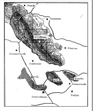
Khao Rao Thian Thong community, Mu 10 of Noen Kham sub-district, Noen Kham branch district, Chainat province, is located 60 kilometers southwest of Chainat provincial town, and about 18 kilometers from Hanka district. The community is situated in the central region of Thailand, and the topography consists of plains interspersed with low hills 89-319 meters above sea level. The hill areas are in Khao Rao Thian Thong national reserved forest.
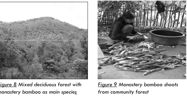
The forest area which the community is managing covers 720 hectares in total of which 158.8 hectares have been established as community forest, under the regulations of the Royal Forest Department in 1999. In practice, the villagers look after the entire area, including both the registered community forest and Khao Rao Thian Thong reserved forest. The forest is mostly deciduous forest in which ironwood (Xylia xylocarpa var. kerrii), Burmese rosewood (Pterocarpus Macrocarpus), Burmese sal (Shorea siamensis), are the major tree species, but the area is mostly covered by monastery bamboo (Thyrsostachys siamensis). Communities distinguish 2 types of forest (1) real forest which is covered mostly by trees with some monastery bamboo, and (2) bamboo forest where most of the cover is monastery bamboo with sparse trees.
medical plants and another forest products such as Melientha suavis, Adenia viridiflorai, Zingiber spectabile, Siam tupil (Curcuma aeruqinosa), Stemona burkillii, water primrose (Diospyros variegata), Jatropha gossypifolia, and wild honey are also favorite forest products.
Figure 7 Topography of Khao Rao Thian Thong community forest, Chainat province
This forest area is important for 14 nearby communities that are located outside the irrigation zone, above the Chao Phraya dam. They rely on rain for growing field crops such as sugar-cane and cassava. There are very few rice fields. The majority of villagers buy rice for consumption. They are rather highly dependent on the forest for their livelihoods. Over 50% of families rely on the collection of forest products for consumption and income. It can be seen that mixed deciduous forest with monastery bamboo as the main species, has an important role in poverty alleviation in each community, with over 100,000 baht annual income for each community. Processed bamboo shoots have become a community-based enterprise, and are shipped in tins to central Thailand and Bangkok for urban consumers.
Community learning and adaptation in natural resource management
Khao Rao Thian Thong community has developed a systematic learning process on forest resource management in order to promote the rehabilitation of deciduous forest with bamboo, without negative impact especially from bamboo collection, which is considered a key resource, earning income for the landless poor. As the matter of fact that community very much depends on the forest and forest products, special attention is then paid on the bamboo shoot due to its major role of extra income generation, especially for the non-property pauperized families. The community has developed a system of bamboo forest management by building agreements on closed and open seasons for harvesting, to allow the forest to regenerate. Meetings are held to establish community consensus on closing the forest at the end of the rainy season when the last batch of shoots have emerged, so that these can grow to become poles. The community has established the following regulations on bamboo shoot harvesting.
x Collection by digging is prohibited
x Collecting shoots longer than 1 meter is prohibited Figure 8 Mixed deciduous forest with
monastery bamboo as main species
x The dates of the closed season are announced every year (between August and September) Khao Rao Thian Thong community forest network and everyone is prohibited from collecting bamboo shoots for sale after closing.
x Penalty for violations is a 100-500 baht fine per kilo (depending on motive)
In addition the community has also been working with ThCCSP to develop a monitoring system for the sustainable harvesting of bamboo shoots as the mean to ensure sustainability community forest management, by brainstorming indicators of good bamboo forests and joining in the design of data collection procedures. The community also collects data on bamboo yields for analysis of sustainability and trends, and for deciding on adjustments for improved bamboo forest management, aiming to emphasize the use of a species at a sustainable level. This relies on quantitative data in managing and monitoring that status of that species.
Monastery bamboo monitoring:
x Monastery bamboo monitoring issues
Community researchers and project staff have chosen issues in bamboo monitoring which may provide answers to the question of the sustainability of bamboo forests. These can be summarized in 2 key issues.
1) Ecological issues on the status of bamboo clumps in the forest area.
2) Socio-economic issues on thevolume of shoots gathered and the number of gatherers.
Each issue would lead to the development of a set of criteria and indicators including data collection processes with a particular emphasis on the participation of the villagers involved, especially bamboo shoot gatherers, local experts, community leaders, community forestry committee members and schools. This collaborative knowledge generation process integrates indigenous knowledge, certain forest survey techniques, and community forest data collection.
x Monitoring methodologies
(1) 3 important indicators were selected for monitoring the bamboo forest
x Indicator 1: Density of clumps, number of poles per clump
x Indicator 2: Proportion of immature:old:dead stem x Indicator 3: Stem size
(2) Joint data collection design by categorizing the status of bamboo forest into 3 conditions: healthy; moderately healthy; and recovering.
(3) Two randomly selected permanent bamboo plots of 10x40 meters in every bamboo forest division
(4) Data collected on general condition, location, and topography
(5) Data collected on bamboo conditions, number of bamboo clumps, number of immature, old and dead stems in each clump in sample plots
(6) Randomsampling of stem size of five bamboo clumps in the sample plots, one in the middle and one 5 steps north, one 5 steps south, one 5 steps east, and one 5 steps west, the sampled clumps being tagged for monitoring in the following year
(7) Data collection on the other species found in the area, such as the wild vegetables and wildlife tracks.
(8) Compilation of data in each area, using basic the statistics, such as total, average,number of clumps per hectare, proportion of immature, old and dead stems, and average stem size
2) Monitoring of bamboo shoots gathering
Results of the study
x Monastery bamboo status
The results of bamboo forest assessment were differentiated, due to the divergent data provided, for specific area analysis and management. Data for areas, mountains, and the entire forest were systematically compiled and interpreted in the final stage for an overall explanation so as to achieve better participatory management of the entire forest.
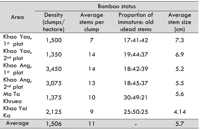
x The first sites represent the healthiest bamboo forest in the Khao Yao area. There were two sampling plots done in this area.
x The second sites were in Khao Ang area, representing bamboo forest of medium health. There were two sampling plots.
x The third sites, representing recuperating bamboo forests, were in Mo Ta Khruea area and Khao Yai Ka area, with one sampling plot per area.
Figure 12 Collecting data on monastery bamboo shoots by gatherer
Table 3
Comparison of sites studiedKhruea 1,375 10 30:49:21
5.6
Khao Yai
Ka 2,125 9 25:50:25 4.14
Average 1,506 11 5.7
Summary of monastery bamboo forest condition at Khao Rao Thian Thong community in 2004
1) The densest area of bamboo clumps could be found in the Khao Ang area where 3,200 bamboo clumps per rai were recorded. Other areas had 1,350-2,000 bamboo clumps per rai.
2) Approximately 7-14 bamboo stems were found in each clump. In the Khao Ang area, 13-14 bamboo stems per clump were documented, clumps in the Khao Yao area were the second largest and the bamboo clumps at Mo Ta Khruea and Khao Yai Ka were the smallest.
4) Overall average stem size was between 4-7 centimeters, which can be classified into three grades of (1) 4-5 centimeters, (2) 5-6 centimeters, and (3) 7 centimeters and larger
x Monastery bamboo shoot productivity
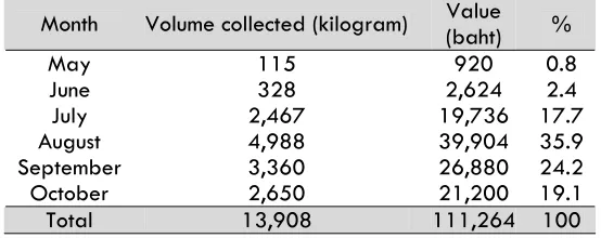
According to the communities’ study, over 60 households were engaged in shoot gathering in 2004, equivalent to 52% of the community. The harvesting season was between May and October. The productivity harvesting in 2004 can be displayed in Table 4.
Table 4 Volume collected
and economic value of monastery bamboo shootsMonth Volume collected (kilogram) Value (baht) %
May 115 920 0.8
June 328 2,624 2.4
July 2,467 19,736 17.7
August 4,988 39,904 35.9
September 3,360 26,880 24.2
October 2,650 21,200 19.1
Total 13,908 111,264 100
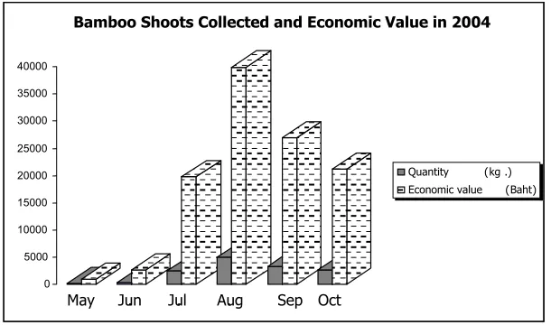
Figure 13 Volume collectedand economic value of monastery bamboo shoots in 2004
Conclusion of the study and implications for adaptive community forest management
From the data gathered in 2004 according to the indicators, it was found that the conditions of the bamboo forest vary in each area, both in density of clumps, number of stems per clump, ratio of immature, old and dead stems, including the products gathered each month during the harvest season. However, there were important ecosystem and socio-economic issues which required management and monitoring.
x Ecosystem management issues
(1) The proportion of old and dead stems at Khao Yao and Khao Ang was relatively high. Therefore the communities could appropriately plan the use of these old and dead stems, as a way of maintaining the health of the bamboo forest.
0 5000 10000 15000 20000 25000 30000 35000 40000
May Jun. Jul. Aug. Sep Oct
Bamboo Shoots Collected and Economic Value in 2004
(2) The bamboo in Mo Ta Khruea and Mo Yai Ka in the process of regeneration from earlier die-back, so there is a large proportion of immature stems and the stems are small. Therefore, there is a need for a plan to promote clump growth, to take great care in exploitation.
(3) It was found that during the August and September period, when productivity is high and the forest is considered closed, there may be an impact on gatherers. However, during October, there is a quantity of shoots that can be gathered. Nevertheless, it is necessary to consider the size and quality of shoots and seasonal fluctuations, which in 2005 were part of the decision about the closed season for harvesting.
x Socio-economic issues
(1) The participatory study on bamboo production
quantities provided a greater chance for gatherers to join in monitoring and forest management decision-making systems. The information supplied on quantity allowed everyone to reach a common understanding on forest conditions.
Case Study 2: Grapsoid crab and mangrove ecosystem monitoring: Prednai community forest, Mueang district, Trat province
Prednai community: from orchard to coast
Prednai village is located in Mu 2, Huang Nam Khao sub-district, Mueang sub-district, Trat province. The total 378 hectares area of the village includes residential plots, public land, and agricultural land. The community situated on high ground approximately 200 meters above mean sea level. To the east of the village are para rubber plantations and fruit orchards. To the west are shrimp farms, and beyond these are mangroves.
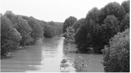
The community mangrove forest area that Prednai community uses is approximately 1 kilometer to the west of the village. It covers approximately 1,920 hectares with 12 main canals and 6 minor canals. The area was under a concession in the past. The forest species found can be divided to several vegetation zones. On the high ground, Olerodendron inerme, banyan, paper-gum, hibiscus tillaceus, and cycadcan be found. The soil composition is clay over mixed soil with sufficient leaf litter. The second zone has Duabanga grandiflora, Xylocarpus granatum, Bruguiera sexangula, and Palmae. The next zone has Xylocarpus granatum, Xylocarpus gangeticus, Lumnitzera littorea, Rhizophora apiculata, and Duabanga grandiflora. The coastal zone has Avicennia alba and Avicennia officinal. Near the canals are found Rhizophora mucronata. The undergrowth includes treebine, sea holly, and Flagellaria indica. The soil in lower areas is mud with peat swamp in flooded areas.
grapsoid crabs and sea crabs, operate natural shrimp farms and raise Cromileptes altivelis fish. Most products are sold to middlemen who buy in the orchards,while some is sold by the villagers themselves. It can be seen that the occupations of Prednai people are diverse throughout the year.
Figure 14 Prednai mangrove forest, 1,920 hectares restoration area
Grapsoid crab business: the mangrove’s fostering
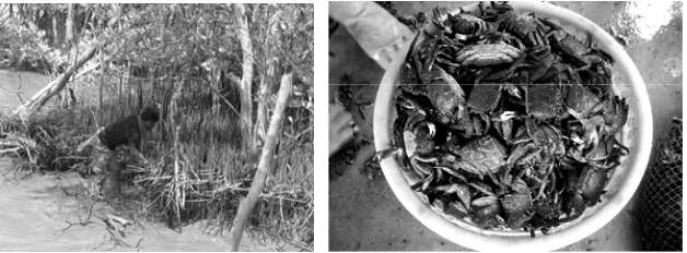
Grapsoid crab catching has been undertaken ever since the village was established. Apart from growing paddy rice and fruit orchard, some villagers have used free time to enter the mangrove to catch grapsoid crab for household consumption. Some pickled crab for sale in the town. Some bartered for rice with other communities. Prior to 1985, the community’s mangrove forest was in very fertile condition and covered over 48,000 hectares (Somsak et al., 2004). There were large numbers of crabs and catching was easy using gas lanterns and a technique of stepping on crab holes and catching them by hand. Villagers would normally go out catching between approximately 7 p.m. and 9 p.m. In the past there were no restrictions on catching grapsoid crab since there were many crabs and few catchers.
killed trees. The mangrove forest was encroached onand heavily degradedFurthermore, the concession holder banned villagers who used to catch crabs from entering the mangrove to catch crabs. This had an impact on the villagers’ exploitation of resources to gain a livelihood and earn an income. Because of the problems of encroachment and degradation, the villagers joined together to call for the revocation of the concession and organize as a group to conserve the remaining 1,920 hectares of mangrove forest. The crab gatherers’ group observed that the number of crabs was lower, and catching needed more time due to an increase in the number of crab catchers.
Management of mangrove resources and grapsoid crab
Since the leaders of the community saw the changes in the mangrove resources, which were reduced, and the problem of push-net trawlers in the sea, they joined together to form a mangrove conservation group to keep a close watch and conserve mangrove forest resource, including animals and plants in the mangrove forest. A management planning process was done through participatory data collection, and forums to collect ideas of the villagers, especially those who utilizing the mangrove forest resources, community leaders, and other groups in the village. The main points of forest management plan are:
1) Division of the area to be managed 2) Agreements on mangrove utilization
3) Rules forresource protection and maintenance 4) Organization structure and administration 5) Expanding the network of mangrove forest management.
Previously the emphasis of the management was on the building of understanding,and rehabilitation of mangrove forest ecosystems. At present, the community is trying to emphasize the sustainable use of resources, especially those economically importance species like grapsoid crab. There are agreements on the mangrove forest utilization which has been divided into zones, along with data collection to monitor the resource conditions, data will be analyzed among gatherers, forest users, and community members.
natural breeding, crab catching is prohibited on the 4th -6th days
of the waxing moon, and the 4th -6th days of the waning moon in
October etc.
Persons outside the community can catch crabs but must inform the committee and follow community rules. Additionally, the community has requested the cooperation of crab buyers is not buying the crabs during the closing period as well as not buying juvenile or small-sized crabs. If any small specimens are found, they shall be returned to the forest.
Mangrove ecosystem and coastal zone monitoring
Currently, there are three main aspects to the community’s resource and mangrove ecosystem monitoring.
(1) Grapsoid crab monitoring employs the quantity of crabs and number of gatherers as indicators. The monitoring methodology is to study the volume of sales to shops that buy crabs, information exchanged with crab gatherers, and community meetings.
(2) The coastal erosion monitoring uses the extent of erosion as an indicator. Community lays rubber blocks and bamboo stakes to reduce wave strength and to host the marine habitats.
(3) Area and fertility of rehabilitated forest restoration is also monitored.
Table 5 Mangrove monitoring data
Resource/indicator 1998 2003 2004 2005
Resource/indicator 1998 2003 2004 2005
3.1 Extent of erosion span
No data recorded
2 meters 2 meters Under study
Figure 17 Economic value of grapsoid crab caught in Prednai mangrove community
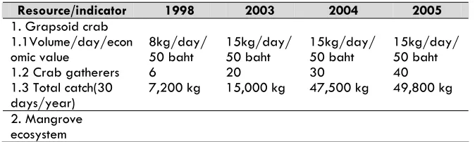
The resources which have returned to fertility and which most clearly indicate the rehabilitation of the mangrove are aquatic animals including shrimp, shellfish, crab, and fish. Grapsoid crab in particular has continually increased in numbers. In 1998 the average crab catch was 7-8 kilograms per person with a maximum of 30 kg., which would take the gatherers all night. By 2003-2005, the average crab catching was 15-20 kg. per person per night taking just a few hours. Crab gatherers’ income has also
1998 2003 2004 2005
increased, which is a good trend for crab gatherers. At present, it is found that an increasing number of people in the community catch the crabs which over 40 doing it as an occupation. Others catch occasionally during term breaks or when the number of crabs is large, so there will be almost 100 persons per night of various aging both sexes. 11-12-year-olds will go with their parents to catch crabs. Some 20-year-olds catch crabs as an occupation since no investment is needed other than labor and a few hours work in the mangrove yields an income of 500-600 baht per night.
It is found from sales to the 3 grapsoid crab traders in the community that annual production is 40-50 tons, with an economic value of 2-2.5 million baht per year. Households which catch grapsoid crab as an occupation can earn 80,000-100,000 baht yearly. Households which catch crabs as a supplementary occupation in the middle of the night and have another day-time occupation to earn a living earn 50,000-70,000 baht yearly from catching crabs. Since 1997, the number of grapsoid crab has been found to increase gradually. This reflects the efficient management of the mangrove ecosystem and the community’s management of crabs which is moving in a positive direction.
Conclusion
Case study 3: Monitoring of Melientha suavis Pierre (phak wan)
for sustainable management: Rom Pho Thong community forest, Tha Takiap district, Chachoengsaoprovince
Rom Pho Thong community forest is located in Mu 7, Khlong Trakraosub-district, Tha Takiap district, Chachoengsao province, in the east of the province, 20 kilometers from Tha Takiap district town and 103 kilometers from Chachoengsao provincial townThe general topography is made up of hills interspersed with undulating plains. High mountains to the east of the village border Khao Ang Reunai Wildlife Sanctuary. The community forest is mixed with agriculture areas on flat land. The area is 120-240 meters above mean sea level.
Rom Pho Thong is an agricultural community. The community forest occupies 240 hectares of dry evergreen forest. The crucial resource is Opilliaceae (Meliantha suavis Pierre) or ‘phak wan’.It is found that villagers from within the community and from outside the community entered the forest to harvest a large amount of Opilliaceae for household consumption and yearly supplementary income. Research studies to assess the status of phak wan and set the agreements for sustainable harvesting is important. Local research was therefore undertaken for a concrete form of management seeking techniques and methods for Opilliaceae management for continuing sustainable production. The objective of the study was to investigate the distribution and status of Opilliaceae in Rom Pho Thong community forest, to gather local knowledge on Opilliaceae management, as well asto seek an approach to develop and manage an Opilliaceae monitoring system by the community.
Community forest resources
and healthy forest. The secondary forest at the foothillsborders agricultural land is in the process of regeneration after damage from forest fires which thinned out the forest. The upper canopy is comprisesLagerstroemia floribunda Jack, Afzelia xylocarpa (Kurz) Craib, and Pterocymbium tinctorium (Blanco) Merr., while the lower canopy is immature trees from natural seedlings and from the old stumps. The land is covered by grass and weed. The undamaged central core of healthy forest has received no damage from forest fires and is in good condition with the important species Pterocymbium tinctorium (Blanco) Merr with Memecylon myrsinoides Bl., Baccaurea ramiflora Lour, Hydnocarpus ilicifolia King, and Melientha suavis Pierre in the undergrowth.
Local wisdom in Opilliaceae management
xHarvesting
xPropagation in agricultural areas
Propagation in agricultural areas uses three techniques.
(1) Propagation from seeds is relatively successful with good budding. However, this technique is somehow problematic. When the seedlings are replanted, they are stunted and growth rates are very slow. Therefore, this technique needs to be developed with methods for looking after the seedlings after re-planting. Moreover, there are trials of planting in the open and in an environment similar to forest shade conditions, which suggest that planting under custard apple trees will yield good growth.
(2) Propagation by root cuttings has a 70% success rate. This technique is currently at the trial stage.
(3) Digging up young trees from the forest for replanting has been found to be unsuccessful since only 20% survived, which is held to be very few and destroys Opilliaceae resources in the forest.
Figure 18 Removal of mature Opilliacea leavestostimulate new growth
Development of indicators for sustainable Opilliaceae harvesting
The harvesters, experts, and community leaders brainstormed on developing the indicators from the community’s point of view. Many indicators were proposed. Using all indicators in monitoring would be difficult, and would use a lot of resources, time, and personnel. Therefore the important indicators should be selected to form a minimum set with the following principles:
1. The indicators should give clearly qualitative or quantitative measurements
2. The villagers have the ability to use them in monitoring 3. Indicators should have a role as umbrella indicators with influence over other indicators
The methodologies and instruments for selecting indicators are prioritization or weighting and analysis of the relationship with other indicators. Three important indicators were selected: annual
Figure 20 Opilliaceae seedling under custard apple tree
production, number of trees cut, and the increase in the number of Opilliacea.
Table 6 Community Opilliaceae monitoring system
Indicator Methodology Frequency Site Comparable
value
x The status of Opilliaceae
plant stems was considered, over 40% were found to be degraded, with shoots and trunks broken, resulting in low productivity. This situation reflects previous harvesting methods, especially the practice of cutting trees and so destroying their propagating potential, with implications for the long-term sustainability of Opilliaceae.
Table 7 Circumference and Height of Opilliaceae trees in 2004
Circumferencecms Heightmeters Zone
Number of
Trees Max Min Ave Max Min Ave
1 41 65 9 15.7 9 1.5 3.30
2 64 70 9 13.75 10 1 3.11
3/1 86 76 4 11.95 9 0.8 3.09
3/2 39 38 9 15.66 8 1.2 3.50
4/1 46 40 4 10.96 9 1 2.60
4/2 25 32 10 16.56 5 1 3.45
Total 301 76 4 14.09 10 0.8 3.17
Table 8 Status of Opilliaceae
trees in 2004Status Zone
(1) Healthy (2) Damaged (3) Broken trunk Total
1 22 16 3 41
2 41 20 3 64
3/1 60 19 7 46
3/2 21 12 6 39
4/1 25 20 1 86
4/2 13 7 5 25
Total 182 94 25 301
51
x Opilliaceae harvesters, Opilliaceaequantities, and Opilliaceae economic value
Studies show that Opilliaceae harvesters can be categorized into two main groups. Approximately 17 community members are regular gatherers and gain an annual supplementary income. A second group comprises harvesters from outside the community whose agricultural landsshare border the forest but who live elsewhere. In 2004, the total amount collected by community members was, over the whole year, at least 650 kg of which approximately 50 kg was for household consumption. The remaining approximately 600 kg go to the local markets where middlemen buy from the community. Some retail by themselves, both in the community and in Nong Khok market. The annual economic value was at least 65,000 baht, an annual supplementary income of 60,000 baht to each of 17 families. This is profit from zero investment, merely from maintaining the forest and gathering.
At present, it is found that the productivity of Opilliaceae is 2.65 kg per tree, with an annual economic value of 212 baht per tree. It is found that the productivity from the forest could be increased if harvesting was sustainable technique, if the number of trees in the natural forest can be increased, and if techniques were developed for propagationin community agricultural areas.
Figure 22 Opilliaceae retailed in the community
Table 9 Opilliaceae Harvesting in 2004 (harvesters from RPT community)
Harvester number
Harvest volume kilogram
Household consumption
Supplementary
income (baht) Note
1 100 0.5kg/time 8,000 Once a week
2 200 N/A 16,000
3 500 0.5kg/time 2,000
4 500 0.5kg/time 2,000
5 800 0.5kg/time 4,000
6 10 0.5kg/time 500
7 20 0.5kg/time 1,000
8 10 0.5kg/time 500
9 50 0.5kg/time 2,000
10 5 N/A For household consumption 11 10 N/A For household consumption
12 10 N/A For household consumption 13 5 0.5kg/time For household consumption
14 22 4kg 1,440
15 12 12kg For household consumption
16 13 4kg
17 4 4kg
Approach to community Opilliaceaemanagement and monitoring
There are three approach to community Opilliaceae management and continuous monitoring in the future.
x Sustainable harvesting in natural forest
From survey data on the condition of Opilliaceae in the community forest, it is found that over 40% of harvesting practices use incorrect methods. Therefore an agreement should be reached on harvesting with the gatherers’ participation. There should be a village meeting to build agreements on proper harvesting methods. Also an understanding should be reached with harvesters from outside the community through conversation to build an ongoing understanding, and public relations.
x Increasing productivity and promotion of natural
propagation
There is very little natural propagation because there are few plants capable of propagating. Also young flowers and fruits are harvested for consumption. Therefore it is necessary to develop agreements not to harvest young flowers and fruits, not to cut trees capable of propagating, to ban the digging up of Opilliaceae plants from the forest for replanting in agricultural areas, and to increase the number of trees by the method of propagation by cutting suckers to create separate plants which will help to promote natural propagation and increase future production in the natural forest.
x Domesticated propagation
Case Study 4: Monitoring of sustainable use of timber and bamboo products: Huai Hin Dam community forest, Dan Chang district, Suphanburi province
Community context
Huai Hin Dam community is located in Mu 6 of Wangyao sub-district, Dan Chang district, Suphanburi province. The community is Thai Karen with a history of community settlement in the area for over 200 years. Huai Hin Dam villagers call themselves ‘Ploew’, which means Pwo Karen, one of largest ethnic groups in Thailand.
The forest area is connected to Huai Kha Khaeng forest and is part of the western forest complex, the largest forested area in Thailand which covers 6 provinces in the west. At present, part of the fields and especially the area of the community’s rotational agriculture has been included in Phu Toei National Park (approximately 192 Ha.), which was formally gazetted at the end of 1998.
Relationship between community and forest
forest areas that the community uses as an important source of food and timber for house repairs. The agreements which the community has collectively set are based on cultural traditions linked to sustainable resource management.
Huai Hin Dam forest comprises mixed deciduous forest and dry evergreen forest. The major forest plants that the Huai Hin Dam community makes use of are timber and bamboo poles are for house renovation, field shelters, and maize and rice storehouses. Bamboo shoots, especially the shoots from Dendrocalamus membranaceus Munr and Bambusa arundinacea (Retz.) Willd are important for almost every family in the community. The forest not only provides direct benefits as a source of food and indirect benefits to the community, but the forest is also linked to the Karen culture. This can be seen from the ceremonies that demonstrate the respect for sacred spirits which look after the soil, water, and forest. The practice of looking after the management of the community forest has for a long time been the positive basis of Karen culture and tradition.
Community forest management
Community initiated the process of managing the forest in the form of a community forest in 1994 with the support of Project for Agro-ecology and Plant Genetic Resource Conservation. The forest being managed by the community is divided into two management zones; conserved community forest (approx. 1,600 ha.) and utilized community forest (approx. 240 ha.). Demarcation was participatory, as was determination of management objectives and regulations on use. In summary, the conserved forest will be conserved as the source of water for the community and habitat of rare animal species. Community members can collect certain non-wood forest products, but there is a strict prohibition on logging and hunting including resident animals and those with young. The utilized forest is an area for gathering of medicinal herbs, wild vegetables, dyestuffs, and household wood supplies as long as this does not in any way degrade the forest.
The process of community forest management monitoring
xDeciding monitoring issue and objective
The initial stage is a review of the management objectives and key community management issues, with reference to the community’s management zones. From an evaluation of the current state of community forest management, the community chose to carry out monitoring of sustainable utilization of the utilized forest over 2-3 years since this is an issue that the community saw as important in the development and improvement of the community’s management and since it is an issue that will help relevant outsiders and nearby communities see that the forest management of Huai Hin Dam does not affect forest productivity.
xIdentifying monitoring indicators for Huai Hin Dam forest management
The process of developing monitoring indicators was brainstorming by community leaders and related agencies such as forestry officials, development workers, and academics or knowledgeable outside persons. Meetings were arranged where there was a broad exchange of opinions, which were condensed into a set of indicators which are most suitable for the community situation in terms of the feasibility for monitoring studies where the community can participate at all stages.
xPlanning the study and team preparation
The study on sustainable utilization is separated into two parts.
(1) Study on community exploitation, including species used, methods of use, quantities used, and other mechanisms relative to community utilization of timber and bamboo shoot. The study of quantity used is gathered by the community team by developing a data form related to use which is systematically recorded. With regard to the quantity of bamboo shoots used, there is an agreement that the data should be collected from buyers. In Huai Hin Dam community, there are only 2-3 buyers; therefore it is easy to record purchases every day. Data on methods of use and factors relating to use can be gathered by talking to the users.
Results of the monitoring
x Timber
The monitoring by Huai Hin Dam community shows that the community’s use on timber did not affect the natural regeneration of trees in the forest or the forest ecosystem. This is the result of to several factors.
1. The method of tree harvesting and level of harvest by the community was mostly for house repair and construction, so trees were selected for good characteristics and size of core. Another feature was that the tools used for processing and transporting the timber out of the forest limited the size of trees cut to those with a circumference of 90-120 cm. The removal of tress from the forest is a form of selection based on the need quality and size of the tree.
2. The scale of cutting is set by the community at a maximum of 25 trees per year. The estimated use is even lower than the estimated carrying capacity of this forest.
3. The number of mature and juvenile trees was moderately good. Measures must be considered for better maintenance so regeneration improves.
4. Physical data on the utilized forest showed that the canopy in general is at an appropriate level and there have not been any wide exposed areas. In addition, the community has other agreements and prohibitions on tree harvesting, e.g. a prohibition on harvest in the vicinity of streams. These are further control mechanisms.
x Bamboo shoots
The ratio of juvenile, mature, and dead stems of ‘pii nuan’ (Dendrocalamus membranaceus Munro) in figure 28 and 29 could equivalently shows similarity to ratios in natural bamboo forests. Generally, the ratio of bamboo in natural forests in Thailand is 8-10% of juvenile stems of one year, 60-70% of mature stems of 2 years or more, and 20-30% of dead standing stems (Watanabe, 1972) with an average density of 53 clumps per rai. This indicates that the capacity of the bamboo in terms of soil cover and soil adhesion is at an appropriate level.
Note: immature or juvenile trunk is 1 year old, old trunk is 2 years old and older Figure 28Dendrocalamus
membranaceus Munro ratios in
April, 2004
Figure 29 Dendrocalamus membranaceus Munro ratios in