CR-Form-v3
CHANGE REQUEST
WCS
CR ?
rev-
Current version:1.1.1
For HELP on using this form, see bottom of this page or look at the pop-up text over the symbols.
Proposed change affects: AS Imp Spec X Best Practices Paper Other
Title: WCS change request - Summarize CRS uses
Source: Arliss Whiteside, WCS 1.2 RWG
Work item code: Date: 2008-01-27
2007-12-21
Category: D (Add needed information)
Use one of the following categories: F (Critical correction)
A (corresponds to a correction in an earlier release) B (Addition of feature),
C (Functional modification of feature) D (Editorial modification)
Reason for change: WCS uses Coordinate Reference Systems (CRSs) in widely distributed parts of the specification, making difficult reader understanding of the CRS usage differences and similarities.
Summary of change: Add a summary of all CRS uses in Subclause 7.5 of WCS 1.1.
Consequences if
not approved:
Clauses affected: 7.5, F.2
Other specs Other core specifications
Affected: Abstract specifications
Best Practices Papers
Supporting Doc.
Other comments: This change request is to the approved WCS version 1.1.1 [OGC 07-067r2].
Status
Disposition
Add new Subclauses 7.5.4 through 7.5.
6 7
to the WCS specification as
follows:
7.5.4 ImageCRSs used in WCS
WCS 1.1 uses the specialized form of ImageCRSs specified in the GML 3.1.1 grid CRSs profile [OGC 05-096r1 with Corrigendum 1 OGC 111 and Corrigendum 2 OGC 06-146]. Each coordinate value in an ImageCRS is the index of a spatial position in the image, with units of Grid Spacings, see Subclause 10.9 of [OGC 05-096r1]. To refer to a recorded pixel value, each coordinate value will be an integer. However, to refer to a general position in an image, each coordinate value may include a fractional value to reference positions between recorded pixels.
NOTE 1 An ImageCRS is defined in OGC Abstract Specification Topic 2, which includes a copy of ISO 19111. That ImageCRS is specialized in the GML 3.1.1 grid CRSs profile. Such an ImageCRS has only spatial coordinate axes. A CRS for an image with both spatial and temporal axes can be defined as a CompoundCRS, as defined in OGC Abstract Specification Topic 2. However, no examples of this are now included in this document.
WCS 1.1 uses only ImageCRSs with the origin at the centre of the first recorded pixel, to be consistent with ISO 19123. Negative coordinate values shall not be used, since they would thus reference pixels that do not exist (or are not recorded). Therefore, the
ImageCRS identifier should be changed when the origin pixel is changed, from the origin of between an offered coverage to the origin of and an output coverage that is derived from that offered coverage.
dimension of the ImageCRS. For example, if the offered coverage's ImageCRS is
"urn:ogc:def:crs:OGC:0.0:ImageCRSpixelCenter:ABC123", the output coverage's ImageCRS might be "urn:ogc:def:crs:OGC:0.0:ImageCRSpixelCenter:ABC123DE:987:654”.
When such an ImageCRS is referenced, the first recorded pixel shall be the first pixel in this ImageCRS. For a spatial 2D image, the first recorded pixel has the indices 0,0. For a spatial 3D image, the first recorded pixel has the indices 0,0,0. For a spatial 1D image, the first recorded pixel has the index 0.
In WCS 1.1, all 2D ImageCRSs should be referenced using the URN form specified in Subclause 10.2 of [OGC 05-096r1], namely
“urn:ogc:def:crs:OGC:0.0:ImageCRSpixelCenter:TBD”. Each specific ImageCRS shall be for the image, or image group, whose alphanumeric character string identifier is substituted for the “TBD” in this URN. When these URNs are used, there is no need to provide a definition for each specific ImageCRS, since the definition of this ImageCRS is completely specified in Clause 10 of [OGC 05-096r1], with the exception of the image identifier that shall beis directly included in this URN.
7.5.5 GridCRSs used in WCS
WCS 1.1 uses the GridCRSs specified in Annex F of this document. Each coordinate value in a GridCRS is the index of a spatial position in the grid coverage, with units of Grid Spacings (like an ImageCRS). (Coordinate values in a GridCRS are NOT in the
referenced GridBaseCRS.) To refer to a recorded pixel, each coordinate value will be an integer. However, to refer to a general position in a grid coverage, each coordinate value may include a fractional value to reference positions between recorded pixels.
The origin of a GridCRS may be at either of the following alternatives:
a) The origin of a GridCRS may be the first pixel recorded for that grid coverage (similar to an ImageCRS). In this case, negative coordinate values shall not be used, since they would reference pixels that do not exist (or are not recorded). Also, the GridCRS definition identifier should be changed when its first pixel is changed,
between from the origin of an offered coverage and to the origin of an output coverage that is derived from that offered coverage. Specifically, the GridOrigin value(s) should be changed.
b) The origin Alternately, the first pixel value recorded for a grid coverage may be located at any grid point in the specified grid. In this case, negative and positive coordinate index values may be used, since they reference pixel positions that are defined, but may not be recorded in the grid coverage. In this case, the GridCRS grid
origin pixel (with 0 valued indices) might may be anywhere in the pixels recorded, or may be anywhere outside not be included in the pixels recorded, and thus not
recorded. Alternately, negative coordinate values may reference pixels that exist (or are recorded). In this both cases, the same GridCRS definition may be used for grid coverages recorded with different first pixels, from the same or different original coverages or images. Also, the GridCRS definition identifier should be changed when any other part of the GridCRS definition is changed, either the GridOrigin,
In WCS 1.1, the definition of each referenced GridCRS is always included in the same operation request or response. This is done since many GridCRSs will be unique. No URN form for referencing GridCRSs is currently specified, but probably should be defined. Such a GridCRS may then be referenced as a SupportedCRS or in a BoundingBox, included in an operation request or response.
7.5.6 WCS use of GridCRSs
In WCS 1.1, a georectified image or coverage always uses a GridCRS, for both offered and output coverages. Each GridCRS specifies the origin and offsets between recorded coverage pixels, in the referenced GridBaseCRS. For a georectified image or coverage, the referenced GridBaseCRS shall be a ground space CRS, which may be either a GeographicCRS, ProjectedCRS, VerticalCRS, or CompoundCRS that combines a VerticalCRS with a 2D GeographicCRS or ProjectedCRS.
NOTE 1 An ImageCRS is not used for a georectified image because a GridCRS provides more useful information. Specifically, that GridCRS specifies the location of the grid points in the referenced
GridBaseCRS, and that information is often needed to usefully exploit this coverage. If used, an ImageCRS would provide only the identification of the image, allowing finding the image pixels. However, an ImageCRS requires that the origin be the first pixel recorded. Furthermore, an ImageCRS should only be used for an image, not for a more general grid coverage.
In WCS 1.1, an unrectified image may use either an ImageCRS, or a GridCRS with its GridBaseCRS being an ImageCRS, for both offered and output coverages. Such a GridCRS may be used when an unrectified image was previously processed, to change the pixel spacing or origin. That GridCRS specifies the origin and offsets between the recorded coverage pixels, each in the referenced original ImageCRS before the known previous processing. If such previous processing is not known, an ImageCRS for the current image may beis used.
NOTE 2 A separate ImageCRS is not used for an unrectified image when a GridCRS is known and used, because that GridCRS allows providing more useful information. Also using an ImageCRS separate from the GridBaseCRS of that GridCRS would not provide needed additional information. The only information in a WCS 1.1 ImageCRS is the identification of the image, allowing finding the image pixels. For an offered coverage, that image identification is not needed separate from the Identifier in the
CoverageDescription. For an output coverage, that image identification should be assigned by the WCS client.
When an unrectified image uses a GridCRS with its GridBaseCRS being an ImageCRS, that ImageCRS should be referenced using a URN, and no separate ImageCRS definition is required. The GridOrigin and GridOffsets parameters specify the pixel positions in this GridCRS relative to the referenced ImageCRS. For example, these parameters can specify different pixel spacings and origin, of the GridCRS relative to the referenced original ImageCRS (before known previous processing). If no previous processing is known, a GridCRS may be used with GridOrigin values of zero, and GridOffsets values that specify the same pixel spacings.
GridCRS definition is stored might be used, except for difficulties in implementing such URL access.
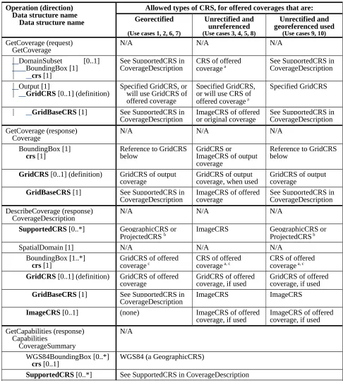
7.5.67 Current WCS uses of CRSs
WCS 1.1 operationrequests and responses frequently include references to a defined Coordinate Reference System (CRS), and sometimes include a CRS definition. Table 1 summarizes these CRS uses in this version of this OGC Standard. In Table 1:
a) In the left column, all the WCS 1.1 data structures and parameters that define or reference CRSs are listed in Bold. All of these are CRS references (with type URI) except for GridCRS (three times), which are GridCRS definitions.
c) In the left column, indented lists are used to identify which larger data structures and operation request or response contains each listed CRS reference or definition. The multiplicity of most data structures and parameters is indicated using UML notation. d) In the other three columns, the allowed types of CRSs are listed for each CRS
reference or definition, for each of three conditions based on the nature of the offered coverage. These conditions map to the use cases described in Annex G and listed in the table header.
e) In the second column, the allowed types of CRSs are listed for a (previously) georectified offered coverage.
f) In the third column, the allowed types of CRSs are listed for an unrectified offered coverage that is not (known by the WCS server to be) georeferenced. This column also applies if the unrectified offered coverage is georeferenced, but the WCS server is not requested to apply, or cannot apply, the (known) georeferencing coordnate transformation.
g) In the right column, the allowed types of CRSs are listed for an unrectified offered coverage that is georeferenced when the georeferencing coordinate transformation IS used by the GetCoverage operation to georectify that image. If the unrectified
Table 1 — WCS uses of CRSs
Operation (direction) Data structure name
Data structure name
Allowed types of CRS, for offered coverages that are: Georectified
CoverageDescription CRS of offered coverage a See SupportedCRS in CoverageDescription
Output [1]
GridCRS [0..1] (definition) Specified GridCRS, orwill use GridCRS of offered coverage
CoverageDescription ImageCRS of offered or original coverage See SupportedCRS in CoverageDescription GetCoverage (response)
Coverage N/A N/A N/A
BoundingBox [1]
crs [1] Reference to GridCRSbelow GridCRS or ImageCRS of output coverage
Reference to GridCRS below
GridCRS [0..1] (definition) GridCRS of output
coverage GridCRS of output coverage, when used GridCRS of output coverage
GridBaseCRS [1] See SupportedCRS in
CoverageDescription ImageCRS of offered coverage See SupportedCRS in CoverageDescription DescribeCoverage (response)
CoverageDescription N/A N/A N/A
SupportedCRS [0..*] GeographicCRS or
ProjectedCRS b ImageCRS GeographicCRS or ProjectedCRS b
SpatialDomain [1] N/A N/A N/A
BoundingBox [1..*]
crs [1] GridCRS of offered coverage c CRS of offered coverage a, c CRS of offered coverage a, c
GridCRS [0..1] (definition) GridCRS of offered
coverage GridCRS of offered coverage, if used GridCRS of offered coverage, if used
GridBaseCRS [1] See SupportedCRS in
CoverageDescription ImageCRS ImageCRS
ImageCRS [0..1] (none) ImageCRS of offered
coverage, if used ImageCRS of offered coverage, if used GetCapabilities (response)
Capabilities
CoverageSummary
N/A
WGS84BoundingBox [0..*]
crs [0..1] WGS84 (a GeographicCRS)
SupportedCRS [0..*] See SupportedCRS in CoverageDescription
a The CRS of an unrectified offered coverage may be an ImageCRS or a GridCRS with a GridBaseCRS that is an ImageCRS. b In addition to a GeographicCRS or ProjectedCRS, other ground space CRSs may be referenced, including a VerticalCRS or a CompoundCRS that combines a VerticalCRS with a 2D GeographicCRS or ProjectedCRS. These CRS types are sometimes referred to as ground CRSs.
Insert new Subclause F.2.2 (between current F.2.1 and F.2.2) in the WCS
specification as follows:
F.2.2 GridCRS coordinates
Each coordinate value in a GridCRS is the index of a position in the grid coverage, with units of Grid Spacings, see Subclause 10.9 of [OGC 05-096r1]. (Coordinate values in a GridCRS are NOT in the GridBaseCRS.) To refer to a recorded pixel, each coordinate value will be an integer. However, to refer to a general position in a grid coverage, each coordinate value may include a fractional value to reference positions between recorded pixels.
The origin of a GridCRS may be at either of the following alternatives:
a) The origin of a GridCRS may be the first pixel recorded for that grid coverage (similar to an ImageCRS). In this case, negative coordinate values shall not be used, since they would reference pixels that do not exist (or are not recorded). In this caseAlso, the GridCRS definition identifier should be changed when its first pixel is changed, from the origin of an offered coverage to the origin of an output coverage that is derived from that offered coverage. Specifically, the GridOrigin value(s) should be changed.
b) The origin Alternately, the first pixel value recorded for a grid coverage may be located at any grid point in the specified GridCRSgrid. In this case, negative and positive coordinate index values may be used, since they reference pixel positions that are defined, but may not be recorded in the grid coverage. In this case, the
GridCRS grid origin pixel (with 0 valued indices) may be anywhere in the pixels recorded, or may be anywhere outside the pixels recorded, and thus not recorded. In both cases, might not be included in the pixels recorded. Alternately, negative coordinate values may reference pixels that exist (or are recorded). In this case, the same GridCRS definition may be used for grid coverages recorded with different first pixels, from the same or different original coverages or images. Also, the The