RTRW Evaluation and Development Activities in Padang City
Based on Public Perception
Syafri Anwar
Faculty of Social Sciences, State University of Padang Abstract
Regional development is an effort to transform one condition to a better condition which means problems are properly solved in this region. Padang as a city has developed more intensively to the eastern area regarding to the previous research. This research identified that tsunami is a trigger to make people move to this area. In fact, this area is a prone area against tsunami. To cope with this condition, Government issues a regulation that manage how the regional planning in this city. In contrary, buildings still grow in the wester area which is claimed as a red zone for tsunami by government. This growth invites people to come back into this prone area. It shows the inconssitency of government in applying the regulation. This phenomenon is basically an object of this research. This research is aimed at evaluating on perception of Padang citizens against government’s regulation about regional planning. Qualitative descriptive is used in this research based on field data and secondary data.
Keywords: evaluation, regional planning, public perception
1. Introduction
Many people assume that the city is a place that promising a better life, the increasing population in the city is not only of a natural childbirth but also from inmigration. Population growth and activity of the population is a major cause of the growing need for greater space in the city. This encourages growth of cities in the horizontal direction where still have a space that can be utilized.
Spatial phenomenon picture in above also occur in Padang city. As a provincial capital, Padang has primary function of government administration center of trade and services at the same time so it is always progressing and continue to experience the process of compaction, especially in center of the city that is on western region which is based on its geographical located adjacent to the shoreline. However the results of the study in 2010 stating that Padang city progressing physically dominant morphologic leads to the east of the city. This happens because of the earthquake hit the city in 2009 that indicated a potential tsunami. Because of people tend to choose a place to stay on higher ground and keep away from the shore.
Orientation changing of physical development in the city is also driven by government policy direction of the development in the city as outlined in the city RTRW 2010-2030. In factual conditions in the western parts of the city persists development activities. It can be seen from implementation of some activities like construction of two-lane coastal road, hotel and new buildings. On the theoretical and in the fact that buildings will invite people to return to activity in the western region (Hermon, 2014)
The description shows that government policies to guide the development of the area to the east and south of the city contrary to the factual condition that there is any development activities that indirectly attract residents back to the western region is real a red zone based on prone zones tsunami map and not become a destination city development (Hermon, 2016). This situation certainly brings doubts among society towards urban planning because it is directly or indirectly related to society activities in the future and economic activities affects such as trade and services. This phenomenon is interesting to examine, especially in Padang city were vulnerable to the threat of the earthquake and tsunami. Government policy regarding directly of development in the region and its implementation / practice would have to be clarified because thats will affect of the activities of its own people and create the perception among the public. The review was deemed necessary to provide input to government policy makers as well as implementers of development. Relating to the implementation of government policies regarding Padang city spatial layout and observe development activities that happens then the goals to be achieved in this study was to evaluate the RTRW Kota Padang in terms of public perception of Padang
Methods
descriptive quantitative research which gives an idea of the tendency of the public perception of the implementation of government policies regarding city planning through coding and calculation of the percentage trend with computerization. Determining the object of location the research is constituted by:
First: the level of tsunami danger zone, red zone is an area that the highest level of vulnerability / affected by the tsunami disaster. Second: Based on the density of buildings. The western area of Padang has the highest density compared to other parts of the region. The number of buildings which are the red zone is closer to 50% of the total existing buildings in Padang City of approximately 192 thousand buildings (the results of satellite image analysis Kota Padang) This research is a quantitative descriptive research which give a view on the condition of the implementation of the RTRW Kota Padang-based disaster mitigation and current construction activity. The research location is the city of Padang in the red zone. This study is a continuation of spatial phenomena research due to the development of the city and its relevant geographical conditions. The data used in this study are primary and secondary data. The primary data obtained from interviews conducted for several families (KK) who settled in the red zone as respondents. Interviews were conducted with a guide questionnaire. Secondary data in this study of the map and the image of the city of Padang and the direction of policy documents such as spatial development of cities of Padang obtained from department of spatial planning . Population data such as the number of households obtained from the office of provincial BPS and the profile or a general overview of Padang. The population in this study is the community living in the red zone. technique determination of the population utilizing GIS to perform interpretation of Landsat imagery Padang area to determine the number of buildings that are in the red zone is assumed as KK. Based on the interpretation of the results obtained the total population of 85 587 households. The research sample is obtained by referring to the sample table Krejcie and Morgan (1970). In this table the total population will be the withdrawal of the sample reached up to 1 million population. In connection with a study population, so the sample is equal to 384 samples. Laboratory Work for the purpose of designing an interview guide or questionnaires that will be used for the collection of primary data and secondary data to process imagery into maps printed per sheet as a guide to the location of the interview or the respondent's house. By utilizing software Geographical Information Systems (GIS, we can determine the location of the sample with the tools of the software. The input data used is the number of samples and a map of the buildings of Padang in tsunami red zone. Then, SIG will showcase building which will be sampled in the distribution and density of the buildings that represent the population. Laboratory Work related processing primary data obtained of which have been implemented are the stages of data coding. The fieldwork in this study is required in order to collect data primary of public perception with an interview guide in the form of questionnaires and secondary data from related government agencies such as documents Spatial Plan (RTRW) and maps. Data coding or code data is a give a code number to each interview data that is descriptive. This process is done to facilitate the next stage that is to find the percentage of answer to see the tendency of respondents' perception. On This phase calculated percentage of the answer by classifying the same answer every question. The method used to carry out this process is the proposed technique Arikunto (1998). In his analysis of the data to determine the percentage of respondents for each category within a variable then use formula distribution frequency calculation as follows:
P = f/n x 100%
Where :
P = Percentage of respondents
f = Number of respondents were included in the criteria n = total of number respondents
The calculation result is interpreted with the following criteria: 0% : None of respondent.
1-19% : Very few respondents.
20-39% : A small percentage of respondents 40-59% : partially of respondents
Results And Discussion
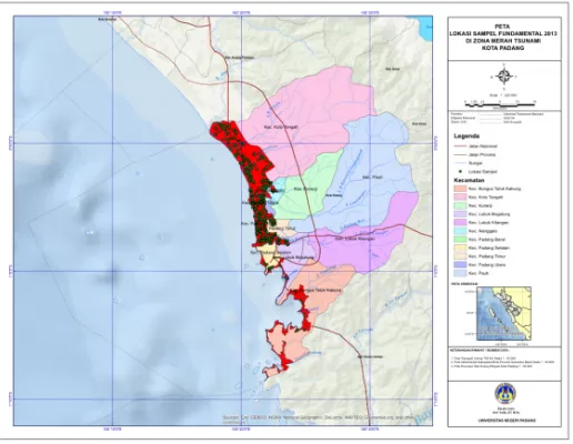
Geographically the city of Padang is in the range 1000 07' 00' '- 1000 32' 00 '' East Longitude and 000 08 ' 00' '- 010 10' 00 '' South Latitude. Padang city has a land area of 600 ± square Kilometers. With a population approaching 900,000 in 2012. In this study, the research area is the tsunami red zone specified in local regulations Padang city object no.4 in 2012. The object of the research is that people who live or work in the red zone. For the determination of sample locations on the basis of the existing buildings in the red zone that the process is done through software tools on a Geographic Information System that takes into account the representation of buildings distributed within the zone. The study area generally is coastal areas are the West side of Padang city. This region extends from the North, subdistrict Koto Tangah to the South, Subdistrict Bungus sackcloth Bay. As an illustration can be seen in Figure 1 below.
Figure 1. Areas and Location Research Sample
RTRW is a measuring instrument or reference to the society and the government in pembangungan (physical) in the space / area or also called directives use and land use of an area. Currently, the government of Padang has compiled a spatial plan, the city in 2010 - 2030 in accordance with the conditions (potential, problems) existing maximize the benefits and reduce to a minimum the negative impact. One of the negative impacts that may arise is the earthquake and tsunami. Therefore, the arrangement and the use of land-based Padang city made with disaster mitigation. In connection with that, then society as a whole must know and understand the reasons for and the background of the land-use regulations. Here are the results obtained on the public's understanding of Padang on RTRW.
Table 1. public comprehension about the condition of the red zone area
No Description Perception % Tendency Interpretation
1 Conditions area (close to the beach, prone to
earthquake and tsunami) 97 %
Almost all respondents know / understand
3% Very few who do not know
2 Distribution of tsunami danger zone (red zone / yellow / green)
70% Most respondents know / understand
30% A small part of that do not know
Table 2. Public comprehension about Implementation of RTRW Related Earthquake and Disaster
3 Encourage residential to develop to north of the
city and to east of the city
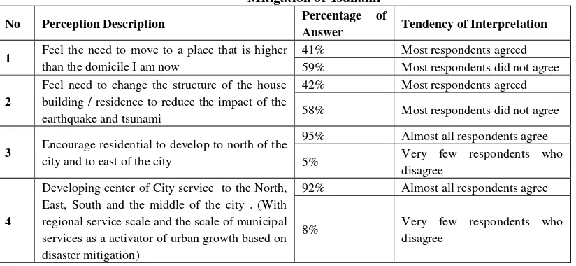
From Table 2 looks society have the perception that the policy of spatial planning on the construction of vertical and relocate the administrative center / service center to the east and north in anticipation of the tsunami is correct, this is expressed by the number of respondents 95% and 92% were agreed, but responded not serious. Evident from the percentage of people who answered the need for relocation and restructuring of residential buildings vertically only around 41% and 42% (half / less than half) and most respondents found not agree with the amount of 59% and 58%.
In connection with the foregoing, it has been done in-deep interviews with respondents and get the results that this perception is due to the invisibility still intensive development activity in the area west of the city so that people are reluctant to relocate to a place that is relatively secure. Another fact is the rising price of land in the area - the area of interest relocation so burdensome for the people, while the average appeal restructuring has been carried out but is constrained mainly to restructuring costs of residential buildings vertically. In addition, people perceive that the lack of firmness of government to relocate settlements to altitude.
Table 4. Public Perceptions about Development in the Western Region of Padang
No Perception description Percentage of
The data in Table 4 interesting to study because implementation perception of RTRW consistently the has been largely answered by the respondents (63%). But this figure is the respondents' answers to middle and high school education with work as housewives and small traders. While a limited number (37%) gave answers that have not been consistent RTRW Padang of respondents were educated to the work of entrepreneurs, professional groups, and skilled labor. It can be presumed that the level of public knowledge affects their perception of the government's policy of Padang on RTRW. While highly educated people tend to answer the RTRW policies have not been consistent with the policy. It is assumed they are well-educated people who are hungry for information at any time through a variety of media, one of which is the government's policy of Padang information about the RTRW (Hermon, 2016).
This study has shown that spatial planning policy based on disaster mitigation of Padang city that have been implemented since the year 2010 or after the earthquake in 2009 not yet give an idea or fact that is clear to the public. Spatial policy, which in essence is a rescue oriented development, to avoid the risk of disaster is merely
theoretical and not practical studies. Theoretically it has a lot that is informed to the public, among others; the
organization, controlling, monitoring and supervision, regulation, control and preservation. All aspects of planning and judgment are necessarily based on a critical assessment of the characteristics of the environment itself. Environmental characteristics of the earthquake-prone, would require proper consideration and planning for it.
This study also proved that people's awareness of the dangers of earthquakes is high. This is evident from the amount of public support for policy development are shifted toward the East Padang. Although many people who are not moving to the east of Padang but this does not mean that low awareness of the dangers of earthquakes. This fact is more dominated by economic and psychological reasons. Economic reasons, they knew the risks of disaster, there is a desire to relocate to the Eastern portion of Padang, but they do not have enough cost to bring hope to move to a safe location. It is assumed, wants the public is increasingly hampered by the increase in the price of land to the east of Padang which each year has increased in price significantly. As for psychological reasons related to the love of ancestral land that constituted also by awards to the historical values that they went through in a long time.
The idea that the educational background, knowledge and experience of someone involve contribute how he perceives a phenomenon and events in the surrounding areas turned out to be true. Therefore, efforts to improve public knowledge about the earthquake and tsunami promptly carried out. These efforts can be followed up with a disaster socialization and socializing RTRW Padang. Socialization will be more effective in two ways, the first to reach the public to location of residence to provide knowledge and training, and both take advantage of the presence of social media (social media), so that people always get actual information about the hazard.
Conclusion
Nearly 50% of the buildings on the city of Padang is in the tsunami red zone . Since the two major earthquakes in Padang, namely in 2007 and 2009 the government has made RTRW of Padang city based on disaster mitigation. In the RTRW map the red zone is the danger zone should always watch out for the people that live in it. Community largely remained in tsunami red zone because constrained funding for relocation. The plan that has been designed in conjunction with the design RTRW Kota Padang in 2010 has not shown any serious efforts from the government to put the people of the city of Padang in position safe from. Development activities of a commercial character is increased in the red zone. This fact certainly confuse the public because they know is the development of a secure means of disaster risk, such as the construction of shelters - shelters, a buffer zone or tsunami hills, high rise building that has a shelter. By building the infrastructure of a commercial character people will focus on one particular point, and if disaster strikes threatened, would be a lot of loss of life. The Society is aware of the dangers of a tsunami, but the ability to moved because it cost prohibitive. This is made worse by the surge in land prices in the East portion of Padang due to the high public interest to seek a safer place. The price of housing-mortgage housing built by the developer is also high, due to the high price of the land. Society tends with negative perspective against implementation of policies RTRW Padang due to its consistency among plans with action. On the one hand, the government promised construction of a buffer means (hill tsunami) and high-rise buildings (shelter) but in reality standing are public facilities such as hotels, flats, and area attractions. This negative perception allegedly due to lack of socialization activities RTRW Kota Padang by the government to the people in the red zone area, especially the less educated people and housewives. Padang city RTRW promising development friendly means of earthquake and tsunami should be realized. Construction of a functioning green buffer zone (hill tsunami), shelter in pockets of society difficult to escape from the place of residence must be no longer merely a promise but actually can be proven. There is a continuous dissemination activities to the public, especially to locations where people were berpersepsi low. Socialization activities should be carried out continuously, if necessary, the public have a public service that every time the duty to give a report on the tsunami hazard.
References
Bergman EF. (1995). “Human Geography. Cultures, Connection & Landscapes”. New Jersey:Prentice Hall Engle wood cliffs
Giyarsih S Rum. (2001). “Gejala Urban Sprawl Sebagai Pemicu Proses Densifikasi Permukiman di Daerah Pinggiran Kota”. Jurnal Perencanaan Wilayah dan Kota.Vol 12.No.1/Marct 2001.12:40-45.P4N-UGM Hadi Sabari Yunus. (2010). “Metodologi Penelitian Wilayah Kontemporer”. Pustaka Pelajar.
Hadi Sabari Yunus. (2008). “Dinamika Wilayah Peri-Urban, Determinan Masa Depan Kota”. Pustaka Pelajar Hermon, D. (2014). “Geografi Bencana Alam”. Radja Grafindo. Jakarta
Lutfi Muta’ali. (2011). “Kapita Selekta, Pengembangan Wilayah”. Badan Penerbit Fakultas Geografi – UGM (BPFG)
Nugroho, Iwan. (2000). “Pertumbuhan Perkotaan dalam Perspektif Sistem Ekologi”. Jurnal Perencanaan Wilayah dan Kota. Vol 11.No.2/Juni 2000.11:63-75.PPK-ITB
Rubenstein JM. (1996). “An Introduction to Human Geography”. Fith Edition. New Jersey: Prentice Hall Inc Suriasumantri JS. (2006). “Ilmu dalam Perspektif. Sebuah Kumpulan Karangan tentang Hakekat Ilmu”. Jakarta :
Yayasan Obor Indonesia
Worosuprodjo, Suratman. (2008). “Pembangunan Wilayah Berwawasan Lingkungan dan Kebencanaan”. Prosiding SEMINAR nasional PIT IGI IX in Medan. Medan: USU Press