PAPER • OPEN ACCESS
Geohazard assessment in Borobudur Temple area, Central Java,
Indonesia
To cite this article: H Murwanto et al 2018 IOP Conf. Ser.: Earth Environ. Sci.212 012005
View the article online for updates and enhancements.
Geohazard assessment in Borobudur Temple area, Central
Java, Indonesia
H Murwanto1, Sutarto1, A Purwoarminta2 and A Sulaksono1
1Department of Geological Engineering, UPN Veteran Yogyakarta
2Research Center of Geotechnology, Indonesian Institute of Sciences, Bandung
Abstract. Borobudur attracted some researchers to study not only about its temple and culture but also the environment. Borobudur environment is very interesting because Borobudur located in the hill and surrounded by swamp. However, behind the beautiful place, Borobudur is vulnerable from natural hazard. Earthquake and volcanic eruption are the main disaster that can destruct the temple. Geological evidence could help the government to protect the temple or to develop the tourism. The aims of research are to assess and analyze natural hazard potential base on geological condition in Borobudur temple area. The research was conduct from 2008 to 2013 with compile primary and secondary data. The data were collected from secondary data validated that which were collected in the field. Several indicators of geohazard i.e. fault, volcanic materials, and landslide sediment were shown the vulnerability of research area. Base on this condition government should consider geological factors to develop and protect Borobudur temple and surrounding areas.
Keywords: Borobudur temple, volcanic eruption, earthquake, disaster
1. Introduction
2
Another potential hazard is volcanic eruption. Bemmelen [13] hypothesis is about the great events of the eruption of Merapi volcano in year 1006. The powerful eruption made volcanic material fill all river until Menoreh mountain. The Progo river was stemmed by material of old Merapi and flooded southern side of Kedu plain including Borobudur area. In November 2010, the Merapi eruption also give impact for Borobudur temple which covered by volcanic ash with high depth. Some researcher believe that chemical contain in volcanic ash can destroy temple material.
Base on the history and explanation, identification geological hazard potential in Borobudur is important to anticipate and conserve the temple. Geological evidence could help the government to protect the temple or to develop the tourism. The aims of research are to assess and analyze natural hazard potential base on geological condition in Borobudur temple area.
2. Methods
The research was conduct from 2008 to 2013 with compile primary and secondary data. The data were collected from secondary data validated which were collected in the field. Tectonic activity in Borobudur area can identify from satellite image as the basic for the analysis of topography, meandering river, and geological structure. Fault identification was done with interpret using ASTER GDEM and support with field survey. Volcanic hazard was assess base on volcanic material characteristic in the research area. The site location of each object was saved by GPS.
3. Results and Disscussion
3.1 Geology
Borobudur plain is a part of Java Island which in the formation processes also influenced by tectonic activities because it is in the subduction zone [1]. Indo-Australian Plate moves to the north and subducting beneath the Sunda Plate, generating trench-arc system called Sunda Arc ([3]; [9]) with initial product are the Tertiary volcanic arc (18-27 million years ago) known as Old Andesite Formation [13]. The plates tectonic movement were triggering the earthquake and affect to change earth morphology. In Borobudur tectonic activity make Kulonprogo dome (Menoreh) faulted which is drowning at the end of Tertiary [13]. In the faulted part of Kulonprogo dome were surrounded by volcanic landforms and formed a basin which is surrounded by mountains called intramountainous basin, then Borobudur Lake was developed in Quaternary.
3.2 Geohazar 3.2.1 Volcanic
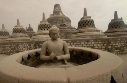
Even though Borobudur was located near many volcanoes but not all of them threat the temple. Merapi is the most active and often threat Borobudur for instance eruption in 2010 that Borobudur covered by volcanic ash (Figure 1). Due to chemical content, volcanic ash can destroy the temple materials and also disturb drainage system.
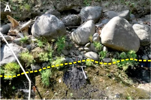
The previous Merapi eruption until now is always triggered lahars. The lahars flow occurs caused by loose material around the volcanic peak, sliding down affected by gravity and rain. Lahar flow has high velocity so can destroy the buildings in surround od the river. Moreover, the volcanic materials will accumulate in the rivers (Figure 2). Black clay deposit covered by volcanic materials from Merapi volcano eruption that flowed through ancient Pabelan River and come down into Lake Borobudur. Some rivers come down in Borobudur area from the upstream of Merapi volcano, including Mangu River, Pabelan River, Kunjang River, Keji River, Putih River, Lamat River and Gung River. These rivers serve as a stream of material from Merapi eruption. Volcanic materials in Borobudur area are found in the river valleys, above the black clay sediments.
Figure 2. Lake sediment covered by volcanic material in Progo river East part of Borobudur area
3.2.2 Tectonic
The result of the interpretation are the lineament of fault scarp and its triangular facetss, fault blocks off set, lineament and deflection of river flow pattern in structural zones. These faults can be clearly shown in the Menoreh hills, in the south of Borobudur area. Other supporting geological data for traces of tectonic earthquakes are faults that form the cliff of Menoreh hills. The faults re-activated to cut the Pleistocene-Holocene bedrocks of Borobudur Plain landform i.e. Progo Fault, Tangsi Fault, Sileng Fault, nearby the temple of Borobudur. The convergent tectonic plates movement releases the energy through activation of fault structure that previously formed, and produced the large faults due to the earthquake.
That event is able to ravage all the buildings of the temple and brought down the cliff of Menoreh hills. Tectonic earthquake events that followed by the tsunami in 938 Saka triggers eruption of the Merapi volcano, Sumbing volcano and Sindoro Volcano. Eruption products are pyroclastic flows or pyroclastic fall "tepra" and cold lahar flood. The materialspile up the temple at the slopes and plains around the volcanoes such as Liangan temple in slope of Sindoro volcano and Hindu and Buddhist temple in southwet-southern side of Merapi volcano that covered by the materials. However, Borobudur and Pawontempleare not covered because they were built on a hill at that time.
4
Figure 3: A. The fault outcrop in Progo river that cut by volcanic breccia and forming a valley. B. Black clay or swamp sediment was cutted by fractures.
3.2.2.2 Sileng fault. Sileng is a river located in the south of Borobudur and Kaliduren is a village name near Sileng river. Both of fault was located in the same river. Sileng fault is a normal fault with direction relatively East to West N 102° E/80°. Then in the west of East of Sileng fault, found structure with a slip fault with N 101° E/75°.
3.2.2.3 Tangsi Fault. Tangsi is a river in the north-west side of Borobudur. The flow direction of Tangsi river was affected by fault structure [8]. These fault structure was resulted meandering pattern of channel along 10 km. Fault activity was trigger emergence of salt springs with high temperature. In the north side of Borobudur (near Ringinanom bridge), the fault was relatively NE-SW.
3.2.3 Landslide
In the south of Borobudur shows Menoreh mountain with steep slopes. The mountain was composed by volcanic breccia with some step fault. A lot of past landslide material found in the research areas. Marsh sedimentation the south of Borobudur area were covered by avalanche material from Mt Menoreh [7]. This situation shows that the susceptibility of landslide is very high especially with type rock fall and flash flood. On the other hand, anual rainfall in this area is very high (2252-3627 mm/year). Landslide in Borobudur could trigger by rainfall and tectonic activity.
Conclusions
The main geohazard in Borobudur temple and its surrounding is volcano eruption, earthquake, and landslide. The conclusions of the paper are;
a. Volcanic eruption was occurred in many time especially from Mt Merapi with pyroclastic fall and ash. The volcano material could damage temple material and structure. Other volcanoes also have same disaster potential.
b. Base on fault mapping, it was clear that tectonic activity has potential to destroy Borobudur. c. Landslide is trigger by geologic and hydrological condition. In Borobudur and surrounding has
potential severe by landslide which was triggered by rainfall and tectonic activity.
Acknowledgment
The authors would like to thank the University of Pembangunan National Veteran Yogyakarta, which give us the trust and the opportunity to conduct this research. The authors also would like to express special thanks to Prof. Dr. Sutikno and Prof. Dr. Sutanto, DEA for the discussion.
References
[1] Clements, B., Hall, R., Smyth, H., and Cottam, M. A. 2009. Thrusting of a volcanic arc: a new structural model for Java. Petroleum Geoscience. v. 15. p. 159-174.
[2] Hall, R. 2002. Cenozoic geological and plate tectonic evolution of SE Asia and the SW Pacific: computer-based reconstructions, model and animations. Journal of Asian Earth Sciences.v. 20, p. 353-434.
[3] Hamilton, W. 1979. Tectonics of the Indonesian region.USGS Professional Paper, 345 p.
[4] Haryono, T. 2013. Borobudur temple and the ancient Javanese. Proceeding of 6th International Experts Meeting on Borobudur, p. 95-102.
[5] Gomez, C. et al., 2010. Borobudur , a basin under volcanic in fl uence : 361 , 000 years BP to present. Journal of Volcanology and Geothermal Research, 196(3–4), pp.245–264. Available at: http://dx.doi.org/10.1016/j.jvolgeores.2010.08.001.
[6] Murwanto, H. et al., 2004. stood by a natural lake : chronostratigraphic evidence historical implications and. , 3(2004), pp.459–463.
[7] Murwanto, H., Purwoarminta, A. & Siregar, D.A., 2014. Pengaruh tektonik dan longsor lahan terhadap perubahan bentuklahan di bagian selatan Danau Purba Borobudur Tectonics and landslides control of the landform changes in the southern part of Borobudur ancient lake. , 5(2), pp.143–158.
[8] Nossin, I., J., and Voute, C. 1986. Notes on the geomorphology of the Borobudur plain (Central Java, Indonesia) in an archaeological historical context. Symposium on Remote Sensing for Resources Development and Environmental Management/Enschede, Netherland.
[9] Prasetyadi, C. 2007.Evolusi tektonik Paleogen Jawa bagian timur.Dissertation. Bandung Institute of Technology.unpublished.
[10] Prasetyadi, C. 2012. Exploring Jogja Geoheritage: The Lifetime of an Ancient Volcanic Arc in Java. Proceedings of the 1stEarth Science International Seminar. p. 387-384.
[11] Suhandini, P. 2011. Banjir bandang di DAS Garang, Jawa Tengah: penyebab dan implikasinya. Dissertation. Fak. Geografi UGM.
[12] Sutikno. 2013. Borobudur temple and the ancient Javanese. Proceeding of 6th International Experts Meeting on Borobudur, p. 57-72.
[13] van Bemmelen, R.W., 1949, The Geology of Indonesia, Vol. IA: General Geology of Indonesia and Adjacent Archipelagoes, The Hague.