ANCIENT SETTLEMENTS ALONG
THE SAVA RIVER
Marija Buzov Institute of Archaeology Ljudevita Gaja 32 HR - 10000 Zagreb e-mail: [email protected]
M
aterial remains from antiquity, texts by ancient writers, survey of old cadastral maps and plans and aerial photographs play a crucial role in the research of the development of ancient cities and urban planning, as in the process of inspection and reconnaissance we can use them for recognizing and identifying ancient settlements. To study the urbanism of the ancient city is to research its life. Archaeology, through its methods, follows this development, dates finds, observes and records changes wherever possible, registers innovation in urban layers as well as phenomena mani-fested in the construction, ups and downs, destruction and reconstruction, determines changes and additions that appear as expressions of new ideas or higher powers.Many factors pertaining to relief, hydrography, composition and quality of soil, as well as climate, have an impact on the position of a city and its materialization, eventually influencing survival and progress of the city.
The paper discusses the ancient settlements built along the Sava river – their scope and geographic features, sources, litera-ture and previous research, types and development of settlements, and the administrative and territorial division.
Key words: ancient cities, urban planning, Pannonia, Siscia, Cibalae, Marsonia, villae, ancient settlements
Marija BUZOV
In the part of the Roman province of Pannonia that presently lies within the borders of Croatia there were important cities of Siscia, Mursa, Cibalae and Marso-nia. In addition to these cities, there were a number of smaller settlements, baths, stations and villae rusticae. One of the outcomes of the fact that the Roman Em-pire had no serious adversary through several centuries is that settlements started to be built in lowlands. Even though urban planning was one of the basic features of the Roman civilization, it was impossible to avoid a cer-tain monotony in the selection and implementation of
the rectangular layout, generally characterized by sym-metrically organized streets, squares and architectural and sculptural masses of colonnaded architecture.
In discussing the architectural heritage of antiquity we mainly have in mind the heritage related with urban spaces, that is, towns, inadvertently disregarding or for-getting the architectural heritage of rural areas, which is likewise of exceptional value for the research of ancient urbanism, and thereby also colonization.
Many factors pertaining to relief, hydrography, com-position and quality of soil, as well ase climate, have an
UDK 904:911.37>(282.24 Sava)(210.5)“00/02“ Original scientific paper
Received: 1.07.2011. Approved: 16.08.2011.
inhabitants and in size. The interior design, construc-tion and architectonics of the city are condiconstruc-tioned by the type and general features of a dwelling house as the basic element of its building substance. Domus, a single-family residential structure with an interior courtyard, was the general type of Roman residential architecture. This type of building developed through centuries of Roman architecture, from modest autochthonous Ital-ic forms to sumptuous ones influenced by the dwelling cultures of Mesopotamia, Egypt, Crete, Greece and the Hellenistic world. With greater or smaller variations, the domus is a transformed ‘tarma’, ‘megaron’ or ‘pasta’, a ground-floor or one-storey house with rooms organ-ized around a common interior courtyard – atrium.3
In comparison with the contemporaneous Greek house, the traditional Italic or Etruscan-Roman house appears quite modest, while in comparison with the later Hellenistic house it can almost be described as primitive. This applies in particular to houses built in colonies, considering that the first colonists, as the lower class of the Roman society—humiliores—could hardly be considered exponents of the dwelling culture. Naturally, they conveyed the basic idea of the modest semi-rural Roman house that gradually adopted au-tochthonous elements encountered in conquered ter-ritories. Under the strong influence of the Hellenistic house, Rome in time developed its own characteristic type of domus with the atrium and peristylium. The rooms of the house cluster around an open or roofed atrium with a pool (impluvium) in the centre of the house. The building is fully closed towards neighbours and the street (unless there is a shop or a workshop opening to the street). The only light in the building came from above or from the garden. Richer houses had one or several additional interior spaces besides the atrium, in which case the front part was used for vari-ous public or business purposes, while the more luxu-rious rear part contained private spaces of the family. Large families with servants used also an upper storey with dormitories and other quiet and isolated spaces. The peristylium with fountains and sculptures was of-ten doubled and linked with spacious gardens behind and around the house.
Such a low and relatively extensive architecture of independent family domus fit into the system of the in-sulae – residential blocks, covering the entire residential territory of the city. Naturally, the density of construc-tions in the poorer areas was far greater due to the re-duction in number and size of residential spaces. Gar-impact on the position of a city and its materialization.
These factors in fact have bearing on the survival and progress of the city. In fact, already during the Augus-tan period Vitrivius1 advised about the choice of the
position to build a city, how to orient its streets, how to use favourable and avoid unfavourable climatic fac-tors. Vitrivius instructs about the construction of urban fortifications, streets and squares, about the positioning of temples and other public structures, as well as about aesthetics, proportions and symmetry of urban spaces. Therefore, Vitruvius for the most part does not theorize but—analyzing the problems of a city—provides gen-eral rules for its organization and construction. Same as Aristotle did for the Greek city, Vitrivius, through a series of practical instructions and recommendations, analytically observes each element of a city in its spe-cific function, but at the same time in the function of the whole.2 Somewhat naïve and banal as his theories
may seem today, these were the highlights of the urban-istic theory of the time and the sum of the architectural practice of entire antiquity.
Administrative norms determining conditions for building appeared very early in the Roman urban plan-ning. The Law of the Twelve Tables, created in the mid-5th century BC, directly impinges on the area of city build-ing. Regulations on limitation contain a number of di-rectives regulating and limiting property rights over re-al-estates in general, particularly over municipal land. Ancient Roman law set down the dimensions of city
streets, which the users have to give to the community, as well as to maintain them. Streets are divided into three categories – Iter, as a pedestrian street at least 0.66 m wide, Actus, at least 1.35 m wide, and Via, as a vehicle road, with a minimum width of 2.70 m. These regula-tions were supplemented with numerous rules about regulation lines in construction, limitations to building in depth and height, regulations on the maintenance of roads, construction monitoring, permanent util-ity services etc. Lex Iulia Municipalis from 45 BC, and Vespasian’s decree (60-70 AD) regulate in detail issues of maintenance and furnishing of streets, construction and repair of buildings, procedure of expropriation of land and other property in the city etc. It is important to mention that the promulgation of legal regulations and rules created appropriate instruments for dealing with problems pertaining to the building of cities, spa-tial organization and regulation – problems that grew parallel with the increasing urbanization of the ancient world and the steady rise of cities both in number of
1 VITRVV. De arch. 1899, Vitruvius 1999. 2 MILIĆ 1994, 192.
3 For a development of dwelling culture
and dwelling house in antiquity see: E. CAMESAICA 1968.
4 The plan of insulae and even of the forum
in Zadar almost entirely conformed to these norms.
5 MILIĆ 1994, 199. 6 MILIĆ 1994, 199. 7 MILIĆ 1994, 199.
The economic development and increasingly more patent stratification of the Roman society resulted in differentiation and growing zonation of the city on the economic basis, i.e. into the areas of elite and luxurious living separated from the quarters of the poor. Howev-er, social differences were not so pronounced as to leave a lasting trace in the urbanism, except in metropolises, where incidents between the city aristocracy and the plebs could be considerable, particularly during the later Empire, when dissension between the rich and the poor sometimes reached frightening proportions.
City blocks of insulae are defined by the basic net-work of the rectangular system of streets and, accord-ing to the theoretical specifications of Roman survey-ors, should ideally measure 120 x 240 feet (around 36 x 80 m), i.e. cover approximately 2900 m2. However, such elongated insulae with a 1:2 ratio are very rare.4
In contrast to the Greek (colonial) and Hellenistic city, where markedly elongated blocks consisting of a double row of residential structures prevail, the concept of Ro-man urbs quadrata is analogous to a square or almost square shape of the insula. Its dimensions vary from the minimum 21 x 21 m (Timgad) to the maximum 100 x 100 m (Trier), and such square insulae are oriented equally on all four bordering streets regardless of car-dinal points and the traffic character of the street. The parcellation system within such insulae, particularly larger ones, offered wide possibilities regarding the par-tition of land, use of space and construction, certainly wider than those offered by elongated blocks with dou-ble rows of buildings.
The unified territory of Illyricum was divided politi-cally and organizationally into the provinces Dalmatia and Pannonia. The province of Dalmatia was let with-out any substantial military strongholds at an early date (provincia inermis) and could therefore exploit all the benefits of peaceful development. Numerous forts— castra and permanent military camps—castra stativa as seats of Roman legions (Emona, Poetovio, Mursa, Singi-dunum etc.)5 developed on the border of the Empire,
which at that time followed the course of the Drava and Danube rivers. Some legionary camps lost their strategic significance and were gradually transformed into colonial cities, with the northward and eastward shit of the limes beyond the Drava and the Danube.6
Simultaneous with this, the hinterland was pacified and colonized, parallel with the reconstruction of existing settlements and foundation of new ones at important political and economical positions.7
den is missing altogether, while the atrium is oten only a modest skylight. Compared with such spaces, palaces of well-off citizens and patricians, with their luxurious gardens and numerous courtyards, can oten cover an area equal to that of an insula.
In the Imperial provinces this type of dwelling varies depending on natural conditions and degree of develop-ment of a given milieu. Nevertheless, the inward orien-tation of rooms and complete isolation from the street remained a common feature of the ancient house, with the exception of residential buildings located along busy and commercial streets.
Parallel with the rise of urban population in larger urban centres, we note a gradual change in their demo-graphic and social structure, and consequently also in the type of the residential building. The extensive, low and thinly spaced domus of the classical type increas-ingly gave way to high and multi-storey buildings, of-ten densely spaced, particularly in the poorer quarters. Unlike the residential buildings of the domus type, the new multi-storey constructions are oriented exclusively to the street – the atrium, peristylium and garden dis-appear without a trace. The cenacula-type apartments grow in height, and are connected with common ver-tical communications – staircases. Ground-floors of these multi-storey tenant buildings are used for shops or other economic purposes. The ground-plan of the building is schematized to the maximum, and the apartment layout is limited to tiny dwelling cells.
The poor state of the dwelling culture is reflected also in the fact that rooms are seldom diversified by function – such tenant apartments lack a separate kitchen or bathroom, and even basic sanitary facilities.
There are a number of transitional types in the de-velopment of residential architecture from the domus oriented inwards to a courtyard and garden to densely-spaced multi-storey tenant cenacula, which allows us to follow the gradual emergence of the new type of urban dwelling that would be passed to the urban planning of succeeding historical periods. Ater the great fire, Nero limited the height of residential buildings to 70 feet (20 m), i.e. six storeys and the ground floor at the most, and the same law regulated the method of building and minimum conditions for stability and fire safety. How-ever, certain documents from a later time reveal that these regulations did not much improve the quality of construction and living conditions in multi-storey ten-ant buildings.
8 KLEMENC 1963, 58; MÓCSY 1967,
586; BUZOV 2000, 55.
9 VIKIĆ BELANČIĆ 1973, 52-54;
VIKIĆ BELANČIĆ 1981; GREGL 1991; NEMETH EHRLICH, VOJVODA 1994, 39-45; SANADER 2001, 12.
10 M.P. KATANČIĆ 1795, 120-144.. 11 VIKIĆ, GORENC 1973, 52-54; VIKIĆ
BELANČIĆ 1986, 39-40; NEMETH EHRLICH 1994, 39-45.
known for a long time, considering the ubiquitous stone monuments.
Matija Petar Katančić documented the position of Andautonia in his 1795 work Specimen philologiae et geographiae Pannoniorum among the remains of ir-regular hexagonal towers of the ancient fortifications in Ščitarjevo.10 His opinion was authenticated in 1934
with the discovery of a milestone of the Emperor Max-iminus. Archaeological investigations have confirmed that the city ceased functioning toward the end of the 4th or the beginning of the 5th cent. AD.
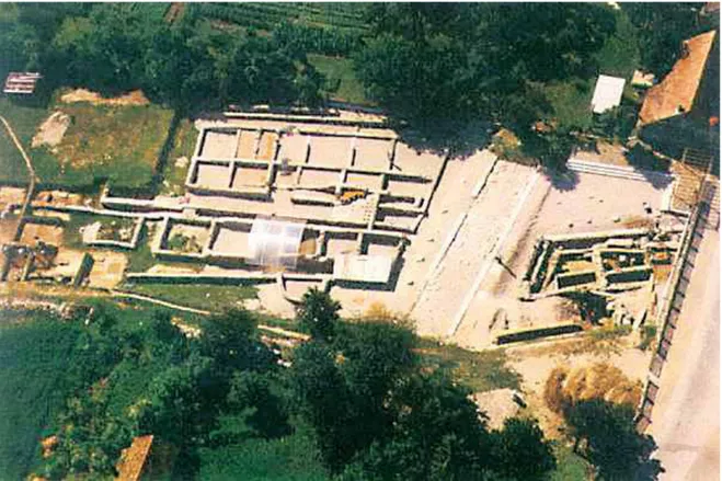
During its heyday, Andautonia occupied a territory of approximately 50 hectares. Among the preserved re-mains from the earliest phase of the urbanization there is the northern part of the sewer system, which proba-bly doubled as a flood-prevention canal. Thick layers of gravel cover the remains from the earliest period of the city. The large baths, whose very well preserved remains were investigated to a large extent, were built in the 2nd cent.11 (Fig. 2). The baths were entered from a city
street through a number of colonnades. It seems that The Romans established two provinces in the area
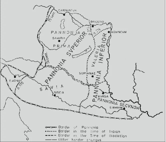
north of the Sava river (Savus flumen) – Pannonia Supe-rior and Pannonia InfeSupe-rior (Fig. 1), stretching to the Dan-ube (Danubius flumen) in the northeast, to the province of Noricum in the northwest, to Italy in the southwest and to the province of Dalmatia in the south.8
In Upper Pannonia (Pannonia Superior), the Romans founded the town of Andautonia (Ščitarjevo) in the 1st cent. AD, in the area inhabited by the tribal communi-ty of the Andautonians (res publica Andautoniensium).9
There are opinions that the Romans had first built a military camp at that place, although archaeology has not yet ascertained this. The city was situated on the right bank of the Sava, near the road leading from Aq-uileia toward Syrmium. Due to this, it is believed that there had been a bridge over the river nearby. It seems that the city was granted municipal status during the Flavians around AD 70.
Andautonia is mentioned in ancient sources (Ptole-my, Geog. II, 14,4) and itineraries (Itinerarium Antonini Augusti 266, 2), but its exact location remained
12 VIKIĆ BELANČIĆ 1958, 75-127; GREGL 1991. 13 HOFFILLER, SARIA 1938, 215. 14 HOFFILLER, SARIA 1938, 214-215. 15 HOFFILLER, SARIA 1938, 213. 16 HOFFILLER, SARIA 1938, 212-213. 17 BRUNŠMID 1902, 126, note 6; ISKRA
JANOŠIĆ 1999, 52;. ISKRA JANOŠIĆ 2001, 31 seq..; SANADER 2001, 25; ISKRA JANOŠIĆ 2004, 169-195. 18 DIMITRIJEVIĆ 1979, 133-148; KRZNARIĆ ŠKRIVANKO 1999, 11-19, 21-29; DIZDAR 1999, 31-37, 39-48; CAMBI 2002, 60.
19 ISKRA JANOŠIĆ 1999, 52; SANADER
2001, 26.
the Pannonian Plain, along the edges of the Fruška Gora, Dilj and Krndija mountains, there runs the Bosut river, on whose slightly elevated let bank lies the Ro-man settlement of Cibalae (Vinkovci).17 In the 8th cent.
BC this area was inhabited by the Illyrians, namely the Breuci.18 The Scordisci—a Celtic folk—arrived there in
the 3rd cent. BC, and continued living there until the ar-rival of the Romans.
In order to secure the passage towards the Danube, the Romans had to conquer the Illyrian and Celtic population. The first campaigns date from 119 BC, but the area was conclusively secured only ater Tiberius defeated the Breuci in AD 6-9. Tiberius celebrated his triumph in AD 12 – triumph ex Pannonies et Dalma-ties. In the frame of the Romanization process, which started with the appearance of the first soldiers, as early as AD 10 Illyricum was divided into two provinces – Dalmatia or Upper Illyricum and Pannonia or Lower Illyricum. By Trajan’s division of Pannonia into Upper or West Pannonia (Pannonia Superior) and Lower or East Pannonia (Pannonia Inferior), Cibalae became part of Lower Pannonia. Upon conquering new territories, the Romans built military camps and forts, towns and cities which they populated with Roman citizens. They covered the conquered areas with roads and bridges to facilitate the flow of the military and goods, creating in that way a border of sorts – limes.19
the baths underwent a reconstruction in the 3rd cent., with the addition of an apse, a new heating system and several smaller rooms.
Andautonia was not a major ancient city, but it was the largest town in the wider area of the Zagreb city. In Zagreb, but also in its surroundings, there were smaller settlements and numerous villae rusticae, as testified by archaeological finds.12
At the end of the 1st cent., the councillors (decreto decurionum) of Andautonia erected a monument to the governor of the province of Pannonia, Lucius Fu-nisulanus.13 In the 3rd cent. they erected a statue of the
Emperor Decius and his wife Herenia Etruscilla. The statues are not preserved, but their inscribed bases are.14 Worthy of mention is an altar to Savus, dedicated
by Marcus Primigenius,15 as well as a relief of goddess
Nemesis from the 3rd cent., dedicated by Julius Vic-torinus, formerly a soldier and now a veteran and mu-nicipal councillor (veteranus decurio municipii Andau-toniensium). The relief depicts the goddess with all her attributes—sword, shield, whip, trident, palm frond and a lit torch—and bears an inscription. The inscrip-tion is important for the history of ancient Andautonia, because it says that Andautonia had a municipal status (municipii Andautiniensium).16
The area of Cibalae shows continuity of settlement from the Neolithic to the present day. In the south of
Fig. 2 Andautonia - remains of baths and architecture
20 ISKRA JANOŠIĆ 1999, 52 seq.
14 m wide, while the canal between the two parts of the rampart was 5 m wide. This happened during the reign of the Emperor Hadrian, a prosperous period for Pan-nonia, although the Marcomannic wars brought an end to this prosperity. In the wake of the peace Rome settled the barbarian Cotini in the area of Cibalae, who then took to draining swamps. The ascension of Septimius Severus to the imperial throne marked the beginning of a more peaceful period and a new period of prosper-ity of Pannonian cities, while Cibalae entered its third urban phase. The defence system of the time consisted of a single earthen rampart supporting a palisade with timber faces and interior filled with soil. Brick walls were erected only at the periphery and presumably also next to the city gate. The younger rampart was 14-15 m wude, and only the western and northern ramparts were furnished with a water-filled moat. In its second and third phases the city had an irregular rectangular shape aligned northeast-southwest with a slight incli-nation, which is reflected in the architecture. The for-tifications of both phases were built on the model of Upon reaching the Danube, the Romans erected
their settlement—which they named Cibalae—at the position hitherto occupied by a Celtic oppidum. It seems that it had features of a fortified settlement – it was surrounded by an earthen rampart with a ditch dug in front of it. The foundation rampart was widened, and partly also reinforced, with brick walls.
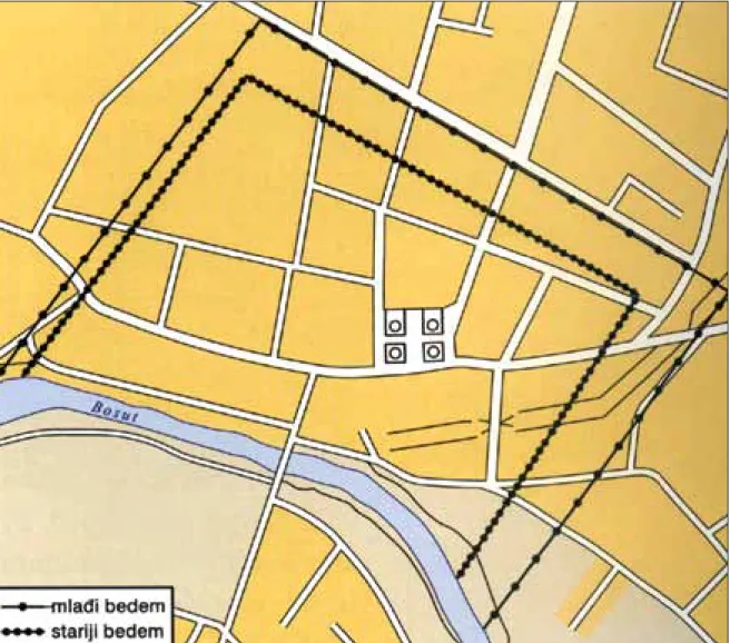
We can define four construction phases in the ur-ban development of the city.20 The first phase is
char-acterized by timber constructions and is related with the general Romanization and the first phase of ur-banization during the Flavians, Vespasian in particular (69-79). The timber phase was ascertained in certain unconnected areas, making it impossible to determine the size of the settlement. The second phase relates to the first solid constructions in Cibalae, when brick and stone became important building materials. Rome in-troduced brick imports into these areas, and the first bricks imported into Cibalae are confirmed by imperial marks I M P – IMPERATORIS. In this phase, the de-fence system consisted of a double earthen rampart
12-Fig. 3 Vinkovci (Cibalae) - ground plan of Roman fortifications (ater Iskra Janošić)
21 ISKRA JANOŠIĆ 1999, 55. 22 SANADER 2001, 26; DIZDAR,
RAD-MAN LIVAJA 2004, 37-53.
23 ISKRA JANOŠIĆ 2001, 106-116. 24 APP. Ill. 10,30. 17.49. 23; PLIN. N.H.
3.131. 3.148; STRABO. 4.6.10; 7.5.2; 7.5.12. 25 PLIN. N.H. 3.148; STRABO. 1903, 296; BUZOV 2003, 177-178. 26 BUZOV 2000, 42-44; BUZOV 2001, 133. 27 BUZOV 2000, 45.
architecture (at the positions of Šokadija, a small sports stadium), a luxurious dwelling structure (frescoes, floor substructure and a post-base, a 3rd cent. alabaster ves-sel and a 3rd cent. metal lamp; the Croatia Osiguranje building – residential architecture with a porch, Duga Ulica Street 10 – a rich Roman house devastated in the second half of the 4th cent. and superseded by modest structures; the site of the future Croatian Centre – an ivory handle of a mirror or some other toilet accessory, with a carved lion’s head on top – 1st-3rd cent.).
The Emperors Valentinian (b. 321) and Valens (b. 328) were born in Cibalae. Their father Gratian had been a Roman soldier who progressed from a body-guard to a praetorian prefect. He retired to an estate near Cibalae. The ancient Cibalae met their end in the incursions of the Goths, who thoroughly looted and laid waste to the city. The last ancient source to men-tion the name of the city was Justinian’s grant from 536 stating that the Emperor granted estates from the terri-tory of Cibalae to the Benedictine order.
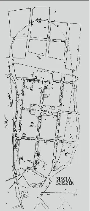
The city of Sisak lies at the confluence of the Kupa into the Sava. In addition to these two rivers, the hydro-graphic network—crucial for the selection of a position to build a settlement—consists also of the river Odra, which empties into the Kupa in the northwest.
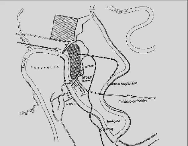
The Illyrian-Celtic settlement Segestica, situated on the right bank of the Kupa river, is the earliest set-tlement beneath present-day Sisak. Its position con-ditioned the placement of Siscia, the city built by the Romans on the neighbouring, let bank of the Kupa. The first mention of Segestica in ancient sources dates from 119 BC, when the consuls Lucius Aurelius Cotta and Lucius Caecilius Metellus were ordered to break into Italy from the north, i.e. from Gaul. The Romans had besieged Segestica already in 156 BC, but most likely without success, because their interest was then turned to Noricum, rich in iron and silver.
Historical sources place the neighbouring settle-ment of Segestica on the right bank of the Kupa,24 at
the position of Pogorelec, while Siscia is placed on the let bank of the Kupa (Fig. 4).25 During a war campaign
in 35 BC Octavian conquered and destroyed Segestica. Appian relates of the defence of the rampart by the people of Segestica during Octavian’s conquest.26 Siscia
first appears in sources starting from 35 BC.27
The Illyrians united in AD 6 and war broke out again. The Romans held Siscia and Syrmium, while the Illyrians controlled the other territories. Tiberius spent time in Siscia, his starting point against the Illyr-the Danubian border camps, which in Illyr-their first phase
were likewise furnished with a double earthen rampart with a timber palisade, to be reinforced with brick walls during Hadrian’s reign. The shape of the settlement, as well as a number of discovered finds, speak of the so-journ of a military unit in Cibalae—most likely one of the cohorts of the Breuci—which must have happened in the incipient phase of the Romanization.21 Similar to
the first phase, the spatial extent of the fourth phase is difficult to ascertain, because it belongs to late 4th cent., when the city was destroyed by a Gothic incursion and when numerous barbarian tribes were passing through the territory of Cibalae. Of these, the Gepids would stay a little while longer. They mostly used the better preserved Roman houses or renovated the less dam-aged ones.
Apart from the rampart (Fig. 3) and the position of the city, today we can speak more clearly about the po-sition of the forum, which was surrounded with public buildings, while direct and indirect finds allow us to determine the layout of the main streets – cardo max-imus and decumanus maxmax-imus, as well as to identify the function of certain structures of residential and public character, many of which—thermal complexes in par-ticular—were furnished with a heating system, the hy-pocaust.
Military veterans who settled in Cibalae also played an important role in the Romanization of local popula-tion, as they were discharged from the army with re-wards – a plot of fertile land and the status of a Roman
citizen.22
During Hadrian’s reign Cibalae were granted mu-nicipal status: municipium Aelium Cibalae. The rule of Septimius Severus between 193 and 211 was a prosper-ous moment for the city. During Caracalla’s rule the city became a colony - Colonia Aurelia Cibalae. Archaeo-logical excavations brought to light the remains of city baths, water supply system and sewer system, pottery, coins, inscriptions, sculptures. Cibalae had a thriving economy, trade and crats, which was facilitated by a navigable river as an important communication route, which was particularly beneficial for grain and timber. We find confirmation that the river fleet frequented Cibalae in a brick marked C F P – CLASSIS FLAVIA PANNONICA. The quality of clay was beneficial to the development of ceramic manufacture, especially with regard to the production of vessels and construc-tion bricks. Around 50 ceramic kilns were discovered in Cibalae.23 Vinkovci yielded the remains of residential
28 ŠAŠEL 1974, 733.
The city was a vibrant commercial centre trading in wheat, wool and other goods. It accommodated the Directorate for mines, as well as financial and admin-istrative institutions. Siscia developed into a large city, built—like all Roman towns—in a plain, with an or-thogonal system of city blocks and a regular grid pattern of streets with cardo and decumanus. Iron ore reached Siscia from the surrounding mines via a road- and river trail. A mint was established in Siscia in the 3rd cent., during the reign of Emperor Gallienus, and remained in operation until the 5th cent. It was imperative to have a mint there in order to pay soldiers’ wages.
During the Emperor Diocletian Pannonia Superior was divided into Pannonia Prima and Pannonia Savia. Siscia then became the capital of the province of Savia and the seat of the governor of Pannonia Savia, the su-perintendent of the provincial treasury and mint and the commander of the fleet. In the 3rd cent. Siscia be-came a diocesan see and the only diocese in Pannonia Savia.
Inscriptions reveal that many veterans, sailors, as well as Italics and people of Oriental origin lived in Sis-cia and its surroundings. The people from the Orient were mostly employed in administrative and commer-ians, whom he conquered at the end of AD 9, which
earned him an ovatio in Rome.28 Siscia became a colony
during the Flavians—most likely Vespasian—around 71 – Colonia Flavia Siscia. At that time also began the first period of urbanization of Pannonia. During Tra-jan, Siscia became part of Upper Pannonia, Pannonia Superior. Crats and trade flourished and Siscia steadily prospered. The Emperor Septimius Severus (193-211), in the third period of urbanization of Pannonia, recolo-nized the area of the right bank of the Kupa. It seems that Siscia stayed loyal to Rome, especially to Emperor Septimius Severus, who had been a governor of Panno-nia for a certain time, considering that the city reached its heyday during his reign. In 194 Siscia was honoured with a new title - Colonia Septimia Siscia Augusta.
During the 3rd cent. new buildings were built and old ones renovated. During Magnentius’ conflict with Constantius II (337-361) Siscia experienced devasta-tion, looting and turmoils. Magnentius took refuge in Siscia, from where he tried to defeat Constantius. Fail-ing in this, he took the looted treasure and fled to Aq-uileia, however, only to meet his death there. Although Siscia did not recover from the devastation, the mint continued operating.
29 BUZOV 2000, 122-144; LOLIĆ,
BUR-MAZ 2004, 125-127; LOLIĆ, BURBUR-MAZ 2005, 175-177; LOLIĆ 2006, 232-233.
30 BUZOV 2000, 176-184. 31 BUZOV 2004, 463. 32 BUZOV 2000, 112-116.
33 MÓCSY 1974, 114. See VRBANOVIĆ,
Excavation diaries for the years 1954, 1957/58, 1962, 1972, 1974, 1976 and 1978.
34 New buildings were constructed in the
following way – the remains would be raised to the ground, filled with a layer of pressed earth, on which a new building would be constructed, consequently on a higher level than the preceding one. This same method was used through centuries, with the result that present-day Sisak lies on average two meters higher than the foundation level of the architecture of ancient Siscia.
35 FABER 1972-1973, 136.
nary, public baths and water supply were built at that time. Unfortunately, there are still many uninvestigated buildings, which could complement our picture of the ancient city. Nevertheless, due to portable and non-portable archaeological finds, careful inspection into the underground of the streets, courtyards and gardens of Sisak, stone monuments deposited in museums, we can deduce and draw a plan of the ancient city and paint a picture of the wealth of ancient Siscia and of the complexity of its architecture (Fig. 5).
A part of an ancient building was discovered dur-ing the excavation of the foundations for a new builddur-ing of the Tailors’ Association in Stjepan and Antun Radić cial jobs, but were also buying large estates. Local
popu-lation integrates. Many new buildings were built in the city, such as a theatre, amphitheatre, triumphal arch, porch, fortification, temple, baths etc.29 At the time of
the highest output of the Siscian mint there could oper-ate as much as 7 officinae.30
Ater the Empire was divided in 395 Siscia was con-quered by the Huns and the Ostrogoths. We have infor-mation about this period owing to the documents from ecclesiastical synods.31
There were three building phases in Siscia.32 The first
phase belongs to the time of the military camp estab-lished between 35 BC and AD 6, when Siscia was an im-portant stronghold of Tiberius. This phase is character-ized by the remains of timber architecture and wooden piles necessary for consolidation and preparation of the terrain for erecting a settlement. It is necessary to point out that the piles used in the first phase to reinforce the terrain remained as the permanent solution also in the remaining phases of the construction of the city. Most of the structures from the first phase were destroyed by fire, as we gather from the layers clearly showing burnt and carbonized timber mixed with soil.
The second phase of construction would belong to the early Imperial period, from the time when Tiberius was encamped in Siscia with 10 Roman legions, until the time that Siscia ceased to be a military camp and became a Flavian colony.33 This phase is characterized
by a combination of stone rubble joined with mortar or lime in combination with timber substructure in foundations. Stone rubble joined with mortar formed foundations for brick architecture. The same technique was used for the fortifications, so we assume that on the eve of the Pannonian-Dalmatian revolt, with the loom-ing threat from the surroundloom-ing tribes, the former mili-tary camp, characterized by timber constructions, was transformed into a considerably better fortified centre with strengthened ramparts and a system of ditches and embankments.
The third construction phase emerged in the period when the city started losing its military role and ater the buildings from the previous phase were destroyed (by earthquake, flood and fire).34 This phase too is
char-acterized by foundations of stone rubble mixed with mortar and laid on a timber substructure, which sup-ported brick architecture, whose determining feature is its monumentality. Bricks bound with mortar and occasionally strengthened with stone were the most commonly used building technique. Fortifications,
gra-Fig. 5 Remains of Roman architec-ture discovered in the substrucarchitec-ture of Sisak (D. Vuković)
36 FABER 1972-1973, 137. 37 FABER 1972-1973, Fig. 29, no. 1, 30. 38 BUZOV 2000, 118.
39 FABER 1972-1973, 146, Fig. 29, no.
4, 44.
40 BURMAZ 2004, 122-124. 41 BAĆANI 2006, 198-200.
lier building, within which it was possible to determine several phases of construction or reconstruction, were discovered on a layer of sandy clay 3.50 m deep. This was a simple ancient building with solidly built walls of bricks and lime mortar, as already mentioned, with primitively constructed floor, i.e. the foundation layer of clay was simply levelled and used as the floor of the room. In time the soil settled and fire broke out, so the rooms within the existing walls were renovated on two occasions. This is revealed by the layers of charcoal that yielded fragments of pottery, amphorae, pithoi and fragments of small vessels for everyday use. Taking into consideration that the material can generally be dated to the early Imperial period, it can be attributed to the first phase of settlement, probably to the period of ex-istence of the military camp.38
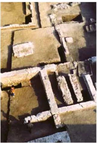
Architectural remains with features suggesting a public building, probably dating from the 3rd construc-tion phase (a crushed-brick mortar), were discovered in the park in front of the railway station in Franko-panska Street.39 In Stjepan and Antun Radić Street,
op-posite the building of the former Popular Committee, excavations revealed transected walls and remains of a large ancient building, whose cellars contained a store of amphorae. The excavation of the foundations for a house in the courtyard of the Post Office in Stjepan and Antun Radić Street also led to the discovery of ar-chitectural remains (Fig. 6). When it comes to recent excavations, it is worthy to mention the finds from the Historical Archives in Sisak, which belong to the re-mains of a building from the end of the 2nd until the 4th cent. Roman architecture was built on an earlier hori-zon from the Late Iron Age.40 A representative
build-ing was discovered on the playground of the ‘22nd June’ Elementary School. The building was a residence of an Street. Constantine’s coin from the Siscian mint,
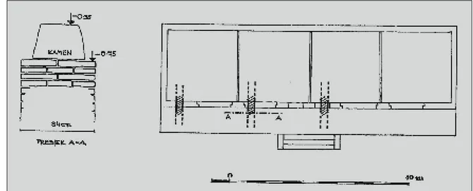
dis-covered in association with the foundation, dates the building to the first half of the 4th cent.35 A large room
measuring 6.6 x 7 m was discovered in the northern part
of the building, surrounded by five smaller rooms clus-tered in the southeastern part of the excavation trench. Unfortunately, as it was not possible to excavate the en-tire surface of the building, and based on the discovery of the foundations, appearing at the depth of around 1.50 m from the surface of the surrounding terrain and continuing down to the depth of 3.50 m, we suppose that this must have been a monumental building that was probably furnished with an upper storey. The walls on the ground floor at the floor level are 0.94 m thick, while the foundation is 1.60 m wide at the base.36 The
foundation consists of stone bound with lime mortar with the addition of crushed brick, while the walls were built with brick bound with mortar made of lime, sand and crushed brick.37 The preserved upper portions of
the walls occasionally reach 0.50 m above the floor lev-el. In a corner of one of the smaller rooms there is a rec-tangular extension in the foundation, measuring 0.50 x 0.60 m, considered by A. Faber to have served as the foundation for a chimney. The excavated portion of the building did not reveal the remains of a hypocaust. The central room was decorated with a polychrome mosaic floor, while the rooms to the south of the central room were decorated with a pavement of hexagonal bricks. These southern rooms yielded fragments of painted wall plaster. Another, earlier architectural layer was discovered beneath that layer. The walls of this layer were built of bricks and lime mortar (without crushed bricks, characteristic for the later period), and accord-ing to the discovered associated material they can be attributed to the Imperial period. The walls of an
ear-Fig 6 Sisak - Drawing of the archi-tectural remains in the courtyard
42 SANADER 2001, 113. 43 ŠARIĆ ŠEGVIĆ 1986, 95-101. 44 ŠARIĆ ŠEGVIĆ 1983/1984, 167-174. 45 BOBOVEC 2001, 167; BOBOVEC 2006, 194. 46 KUKULJEVIĆ SAKCINSKI 1873. 47 Land consolidation joined all private
plots into a single large complex of cultivated land, while the remains of above-ground buildings were removed.
48 BOBOVEC 2001, 167-172; BOBOVEC
2004, 121-122; BOBOVEC 2005, 111-117; BOBOVEC 2006, 195 seq.
49 MIHALJEVIĆ 2006, 202.
The Moslavina region is missing from ancient sourc-es, but it is assumed that it formed part of the Roman state system at the beginning of the 2nd cent., which points to a developed system of communications – roads, along which the Romans built military camps, villae rusticae and rural settlements, some of which in time developed into towns and cities.45
The Roman road starting from Siscia is mentioned in the Antonine Itinerary. At the place where this road divided into two directions—one ending in Mursa and the other in Cibalae—there was a road station – the settlement of Variannis. The Roman complex of Ciglenice was most likely situated next to this road. The site in Osekovo was first mentioned by Ivan Kukuljević Sakcinski in 1873.46 A reconnaissance survey was first
undertaken only in 1972, but already at that time the site was devastated due to land consolidation.47
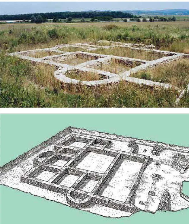
Recon-naissance surveys in 1994 and 1995 ascertained that the remains belonged to a large building complex of Roman Imperial date 48 (Fig. 8, 9). The foundations of
a—pre-sumably—residential structure were discovered on the northern edge of the site. The building was constructed in two phases, i.e. most likely changes or additions were made on the structure during the time it was used. The original building measured 12 x 12 m. The interior is divided into eight rooms of different sizes, two of which affluent city family, as testified by portable
archaeo-logical finds: fragments of marble, fragments of frescoes discovered near and above the hypocaust, ceramic oil lamps, a bronze oil lamp, mosaic tiles, pottery shards, terra sigillata, a quernstone, metal objects – fragment of a bronze lock, key, bone and bronze hairpins, bronze fibulae, crushed brick, fragments of mortar, tegulae and imbrices, hexagonal bricks.41 Unfortunately, this
valu-able find of residential architecture was not conserved in situ, but covered with geotextile and then with soil, upon which the construction of a children’s playground was resumed.
It is important to point out that almost every street in Sisak that lies within the boundary of the ancient centre yielded remains of architecture (Fig. 7).
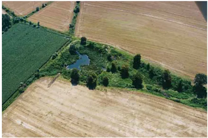
Topusko, a picturesque town in the Kordun region, is situated between the Glina and Čemernica rivers, at the foot of the Nikolino Brdo hill between the Petrova Gora and Zrinska Gora mountains.42 Topusko has been
permanently settled since prehistoric times, as corrobo-rated by the finds of the Lasinja and Retz-Gajary cul-tures, as well as abundant remains of Illyrian artefacts. The reason for this certainly lies in its thermal spring. The presence of autochthonous Illyrian population is proved by anthroponyms, theonyms, toponyms and ar-chaeological finds.43
Topusko developed into an important settlement at the border of Dalmatia and Pannonia. It is identi-fied with the Ad Fines from ancient sources, and in the recent times also with quadrata. The discovery of a milestone indicating the distance to Aquileia speaks of Topusko as an important communication junc-tion, considering that such milestones were placed on important and direct communications, whereas side roads had milestones bearing information about the distance to the first major junction. As the remains of ancient architecture, hypocaust and parts of painted walls were discovered by chance, unfortunately today we cannot say anything about the urbanistic picture of the ancient city. Topusko yielded numerous monu-ments—epigraphic – dedications to deities, sepulchral, and inscriptions by Roman soldiers—that bear witness to intensive life in the town. Interesting finds are arae with dedications to the Illyrian deities Vidasus and Thana, as a couple that during the Romanization proc-ess acquired attributes of Roman deities (Silvanus and Diana – interpretatio romana).
Another testimony to life in the town is provided by grave goods from the ancient necropolises, particularly the unique specimens of amber jewellery.44
Fig 7 Sisak - remains of Roman architecture, 2.-4. st.
50 DAMEVSKI, GORENC 1976, 79-81;
Fig. 8 Osekovo, Ciglenice - remains of a Roman complex
Fig. 9 Osekovo, Ciglenice – draw-ing of the structure (ater E. Butjer)
had apses. Another three rooms were probably added at a later date. On the southeast the building had an open porch with columns, as testified by the remains of bases and fragments of columns, as well as capitals, discovered nearby. Above-ground architecture was not preserved due to the devastation of the terrain.
The archaeological finds reveal that the structure con-tained all the elements expected in a well furnished prop-erty. The building had a water supply, as testified by the almost entirely preserved conduit on the northeastern site, more than 20 m long. The foundations of another building were discovered within that complex towards
northeast. The structure was preserved in two smaller segments – one built of trimmed stone and the other of bricks laid in an irregular herringbone pattern. An area covering approximately 60 m2 was also discovered, with the remains of a hypocaust. Considering the find of a mosaic, these were probably private baths.
The ancient site of Brod at Otrnci is situated in the valley of the Sloboština river in Benkovac north of Okučani.49 This area has long been a convenient junction
of roads leading from the north to south and connecting the Podravina and Posavina regions, as well as the east-west roads connecting central and east-western Slavonia.
MIHALJEVIĆ 2006, 202. 51 DAMEVSKI 1982, 267-268. 52 MIHALJEVIĆ 2006, 203. 53 ČUČKOVIĆ 1992, 49-51; ČUČKOVIĆ 2006, 204-205. 54 MIŠKIV 2006, 238-239. 55 CAMBI 2002a, 489-497. 56 MIŠKIV 1997/1998, 83-101. 57 BRUNŠMID 1901, 137-139.
fort lasted until the 6th cent., that is, until the time of Justinian.
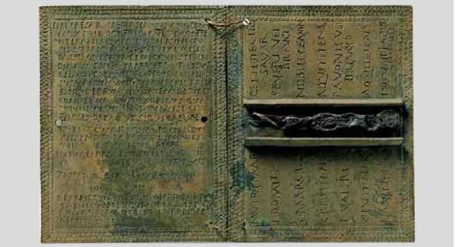
Roman Marsonia (Marsunnia; Slavonski Brod) emerged on the remains of settlements from the Late Bronze Age and from the Pannonian-Celtic period. Marsonia is mentioned in ancient sources, maps and itineraries, and Tabula Peutingeriana positions it on the main Roman road aligned west-east. Although it was believed that Marsonia had been a post station, numer-ous remains of Roman architecture, building material and an abundance of various objects show that Marso-nia was a larger urban centre. Another factor speaking in favour of this is the discovery of a Roman military diploma from the 1st cent. AD, with the first mention of the ancient town of Marsunnia at the location of present-day Slavonski Brod.
The 2002-2003 investigations revealed traces of Ro-man architecture, foundations of building floors, wells and a ceramic kiln, in addition to an abundance of construction material – bricks, roof tiles, mortar, lime and stone.54 Exceptional finds from Marsonia include a
greave—leg armour—and a Roman military diploma55
(Fig. 10). The diploma was issued on 9th February 71 to the centurion Liccaius, son of Birsus from
Marso-nia, a veteran of the Misenum fleet, who was granted Roman citizenship (civitas) and the rigth to lawfully marry (conubium) ater more than 26 years of military service.56 Seals—otherwise rarely found on diplomas—
make this diploma exceptionally valuable.
Marsonia had an elongated rectangular shape, with earthen ramparts and timber palisades. The position of Salvage and conservation investigations carried out
with interruptions between 1953 and 1983 ascertained that this was a luxurious ancient countryside villa with accompanying farm buildings. The villa rustica was built on a carefully chosen position, with excellent en-gineering solutions for water supply, heating and sewer-age used in its construction.50 Nine rooms were
discov-ered, of various functions and different sizes, aligned from the west towards east. The largest room in the villa had a polychrome mosaic floor. The discovered rooms of the villa yielded few portable archaeological finds, only a few coins from the 3rd and 4th cent., and Roman clay vessels. The method of construction and the discovered archaeological finds date the villa to the period between the 2nd and 4th cent.
There is another Roman countryside villa in the im-mediate vicinity of Benkovac, in the village of Cage. It was investigated between 1981 and 1986 and provides evidence of intensive life in this area during the Roman period.51 The remains of a Roman road that connected
these two villas were discovered running parallel with the present road Okučani – Lipik – Daruvar.52
In the wake of the barbarian incursions into the Empire in the 3rd century, fortifications started to be erected on strategic elevations. The first walls in the Old Town of Ozalj, bearing witness to the existence of a set-tlement in antiquity, date from that period. The finds of thick walls, tubuli and a large hypocaust furnace reveal that this was a Roman fort.53 The lack of a more sizeable
portable assemblage points to an exclusively military use of the place. Intensive use and reconstruction of the
Fig. 10 Roman military diploma from Slavonski Brod 1st cent.
58 MIGOTTI 2006, 268.
59 The mentioned inscription is kept in the
Diocesan Collection of archaeological and other cultural material, but lacks details about the circumstances of the discovery.
60 MIGOTTI, ŠLAUS, DUKAT, PERINIĆ
1998.
61 GREGL 1993, 32-34; GREGL 1994,
181-190; PAVLOVIĆ 2001, 109-114; MIGOTTI 2003.
62 CAMBI 2002, 61. SUIĆ 2003, 56.
(Ljubljana), Syrmium (Srijemska Mitrovica) and Emona and Salona (Solin). Štrbinci yielded a diverse portable archaeological assemblage that includes con-struction bricks, mortar, mosaic tiles, inscriptions, tools, glass and ceramic vessels, jewellery, marble, stone, clay, ceramics, metals etc, dated from the 1st to the 6th cent.60
The spatial extent and the quantity and character of objects corroborate and testify to the existence of an urban settlement at Štrbinci (Fig. 11). This is substan-tiated by valuable finds discovered at the necropolis.61
In addition to the mentioned sites, each of which represents a specific settlement type, there were a number of smaller and larger settlement agglomera-tions in continental Croatia, which have not been suffi-ciently investigated and excavated, but only ascertained topographically.
Villae rusticae, as economic building blocks in the hinterland of the limes, play a particularly important role for this part of South Pannonia. All of this speaks about intensive life in antiquity in this area, but at the same time raises numerous questions that we cannot answer at this point, such as the relationship of these settlements and necropolises with regard to Siscia, as well as whether these were Roman villages (pagi) or hamlets (vici). In fact, the insufficient level of investiga-tion into Roman pagi and vici is an acute problem in our area.62
the northern rampart and the exterior ditch were dis-covered in the course of the reconstruction of the mu-nicipal square.
Trial archaeological excavations in the area of Štrbinci started at the beginning of the 20th century owing to Josip Brunšmid.57 The systematic
archaeologi-cal investigations carried out since 1993 brought to the light of day the remains of a prehistoric settlement (the Sopot culture) and the finds from the Hallstatt period at various places. The accurate layout of prehistoric settlements has not been determined, and the discov-ered material has not been systematically analyzed.58
Portable and non-portable remains of a settlement from antiquity were discovered during the mentioned investigations over the entire area of the site. These finds, together with chance finds, speak in favour of the supposition that the Roman town of Certisia was located in the area of Štrbinci. Certisia appears in an-cient sources under different names: Kertissa, Certis-sia, CirtiCertis-sia, Cirtisa, Certis and Certisia. The assumption about Certisia in the area of Štrbinci is plausible, but it has not been conclusively confirmed. Roman Certisia has been confirmed epigraphically by the discovery of a partly preserved marble fragment bearing the inscrip-tion beginning with the words Accede ad Certissiam...,59
but the place where it had been remains unknown. Cer-tisia is marked in the inscription as a road station and a junction of roads (caput viarum) connecting Emona
Fig. 11 Štrbinci a view on a part of the site
63 BUZOV 2000, 171-176.
64 KUBITSCHEK 1928, 1231; GRENIER
1934, 199-213; VASIĆ, MILOŠEVIĆ 2000, 133-138.
tio, statio, praetorium, palatium, civitas and vicus.64 Little
information is available about the construction of road stations in written sources and epigraphic monuments. The number of road stations in our area, as well as their appearance, is another priority of our investigations.
Based on the previous knowledge about the devel-opment of ancient cities and settlements we have ob-served that their development was conditioned by their position, cultural-ethnic origin, economic and socio-political importance, but also by all other histori-cal forces that set in motion the general development of a society. Naturally, the type of dwelling in cities and settlements varied depending on the natural conditions and the level of development of individual centres, but the inward orientation of rooms and complete isolation from the street remain a general feature of the ancient house, with the exception of residential buildings situ-ated next to busy and commercial streets.
Upon conquering new territories, Rome immedi-ately started constructing necessary communications to connect the new provinces with the core area as well as other parts of the Empire. These were big main roads that determined the directions of urbanization of this part of the Roman Empire, as almost all important cities of the Roman period lay on these routes. Along the roads leading from Aquileia to the Danube basin lay e.g. Emona (Ljubljana), Celeia (Celje), Vindobona (Beč), Aquincum (Budimpešta), Mursa (Osijek). The main road that ran through the valley of the Sava river connected Emona, Siscia, Marsonia, Cibalae, Sirmium (Srijemska Mitrovica) and Singidunum (Beograd).63
In addition to the main roads, the Romans expanded the network of vicinal roads, narrower and less well equipped, but laid down in the same way as the main roads.
Along the roads the Romans built road stations, mentioned in sources by various names – mansio,
muta-BIBLIOGRAPHY
BOBOVEC 2001. A. BOBOVEC, Moslavina u svjetlu najnovijih nalaza iz rimskog doba. Histria Antiqua 7, 167-172.
BOBOVEC 2004. A. BOBOVEC, Lokalitet: Ciglenice. Hrvatski arheološki godišnjak 1/2004, 121-122.
BOBOVEC 2005. A. BOBOVEC, Roman complex Ciglenice in Osekovo, u Šegvić, M. i Mirnik I. (ur.), Illyrica Antiqua ob honorem Duje Rendić Miočević, 111- 117, Zagreb, Odsjek za arheologiju Filozofskog fakulteta u Zagrebu, Arheološki muzej u Za-grebu.
BOBOVEC 2006. A. BOBOVEC, Osekovo – Ciglenice, u: Stotinu hrvatskih arheoloških nalazišta. Durman, A. (ur.), Zagreb, 194-195.
BRUNŠMID 1901. J. BRUNŠMID, Arheološke bilješke iz Dalmacije i Panonije IV. VHADns 5, 87-168.
BRUNŠMID 1902. J. BRUNŠMID, Colonia Aurelia Cibalae, Vinkovci u staro doba. VHADns
6, 117-166.
BURMAZ 2004. J. BURMAZ, Sisak – Povijesni arhiv. Hrvatski arheološki godišnjak 1/2004,
122-124.
BUZOV 2000. M. BUZOV, Topografija antičke Siscije na temelju arheološke baštine. Neobjav-ljena doktorska disertacija, Sveučilište u Splitu.
BUZOV 2001. M. BUZOV, O bedemima Siscije. Histria Antiqua 7, 131-143. BUZOV 2003. M. BUZOV, Siscia – grad na tri rijeke. Histria Antiqua 10, 177-194.
BUZOV 2004. M. BUZOV, Problem povijesnog kontinuiteta i diskontinuiteta u Sisciji. Zbornik 1, Pelc, M. (ur.), 463-468.
CAMBI 2002. N. CAMBI, Antika. Zagreb.
CAMBI 2002. a N. CAMBI, Bilješke o ikonografiji rimske paradne knemide iz Slavonskog Bro-da. Opuscvla Archaeologica 27, 489-497.
CAMESAICA 1968. E. CAMESAICA, Storia della Casa. Milano.
ČUČKOVIĆ 1992. L. ČUČKOVIĆ, Ozalj, zaštitna arheološka iskopavanja 1992. godine. Obavijesti Hrvatskog arheološkog društva 24/3, 49-51.
ČUČKOVIĆ 2006. L. ČUČKOVIĆ, Ozalj, u: Stotinu hrvatskih arheoloških nalazišta. Durman, A. (ur.), Zagreb, 204-205.
DAMEVSKI 1982. V. DAMEVSKI, Terenska istraživanja 1981. godine, Benkovac – Cage. VAMZ 15, 267-268.
DAMEVSKI, GORENC 1976. V. DAMEVSKI i M. GORENC, Benkovac kod Okučana, Nova Gradiška – rim-ska ladanjrim-ska vila. Arheološki pregled 18, 79-81.
DIMITRIJEVIĆ 1979. S. DIMITRIJEVIĆ, Arheološka topografija i izbor arheoloških nalaza s vinkovačkog tla. u: Corolla memoriae Iosepho Brunšmid dicata, Izdanja HAD 4, 201-269.
DIZDAR 1999. M. DIZDAR, Brončano doba. u: Vinkovci u svijetu arheologije, katalog izložbe, 31-37.
DIZDAR 1999. M. DIZDAR, Željezno doba. u: Vinkovci u svijetu arheologije, katalog izložbe, 39-48.
DIZDAR, RADMAN LIVAJA 2004.
M. DIZDAR. i I. RADMAN LIVAJA, Nalaz naoružanja iz Vrtne ulice u Vink-ovcima kao prilog poznavanju rane romanizacije istočne Slavonije. Prilozi Insti-tuta za arheologiju 21, 37-53.
FABER 1972-1973. A. FABER, Građa za topografiju antičkog Siska. VAMZ VI-VII, 133-162. GREGL 1991. Z. GREGL, Rimljani u Zagrebu, Zagreb.
GREGL 1993. Z. GREGL, Istraživanje kasnoantičke nekropole u Štrbincima kod đakova. Obavijesti Hrvatskog arheološkog društva 25/2, 32-34.
GREGL 1994. Z. GREGL, Kasnoantička nekropola Štrbinci kod đakova – istraživanja 1993. g. Opuscvla Archaeologica 18, 181-190.
GRENIER 1934. A. GRENIER, L´archéologie du sol; les routes. M
HOFFILLER, SARIA 1938. V. HOFFILLER i B. SARIA, Antike Inschriten aus Jugoslavien. Het I, Nori-cum und Pannonia Superior, Zagreb.
ISKRA JANOŠIĆ 1999. I. ISKRA JANOŠIĆ, Colonia Aurelia Cibalae. u: Vinkovci u svijetu arheologije, katalog izložbe, 51-63.
ISKRA JANOŠIĆ 2001. I. ISKRA JANOŠIĆ, Urbanizacija Cibala i razvoj keramičarskih središta. Za-greb – Vinkovci, Hrvatska akademija znanosti i umjetnosti, Centar za znanstve-ni rad u Vinkovcima, Gradski muzej Vinkovci.
ISKRA JANOŠIĆ 2004. I. ISKRA JANOŠIĆ, Colonia Aurelia Cibalae, Entwicklung der Stadt. The Au-tonomous Towns of Noricum and Pannonia. Pannonia 2. Situla 42, 169-195. KATANČIĆ 1795. M. P. KATANČIĆ, Specimen philologiae et geographiae Pannoniorum in quo
de lingua et literatura Croatorum, simul de Sisciae, Andautonii, Nevioduni, Po-etovienis in Pannonia olim celebrium et his interiectarum via militari mansion-um situ disseritur. Zagrabiae.
KLEMENC 1963. J. KLEMENC, Der pannonische Limes in Jugoslawien. ARR 3, 55-68.
KRZNARIĆ ŠKRIVANKO 1999. M. KRZNARIĆ ŠKRIVANKO, Mlađe kameno doba. u: Vinkovci u svijetu arheologije, katalog izložbe, 11-19.
KRZNARIĆ ŠKRIVANKO 1999. M. KRZNARIĆ ŠKRIVANKO, Bakreno i mlađe brončano doba. u: Vinkovci u svijetu arheologije, katalog izložbe, 21-29.
KUBITSCHEK 1928. W. KUBITSCHEK, s.v. mansio. PWRE, XIV/1, 1231-1252.
KUKULJEVIĆ SAKCINSKI 1873. I. KUKULJEVIĆ SAKCINSKI, Panonija rimska. Rad JAZU, XXIII, 86-157. LOLIĆ 2006. T. LOLIĆ, Sisak. u: Stotinu hrvatskih arheoloških nalazišta. Durman, A. (ur.),
Zagreb, 232-233.
LOLIĆ, BURMAZ 2005. T. LOLIĆ i J. BURMAZ, Siscija – Sv. Kvirin. Hrvatski arheološki godišnjak 2/2005, 175-177.
MIGOTTI, ŠLAUS, DUKAT, PERINIĆ 1998.
B. MIGOTTI, M. ŠLAUS, Z. DUKAT i LJ. PERINIĆ, Accede ad Certissiam, Antički i ranokršćanski horizont arheološkog nalazišta Štrbinci kod đakova. Katalog izložbe.
MIGOTTI 2003. B. MIGOTTI, Pozlaćena stakla sa Štrbinaca kod đakova. đakovo, Muzej đakovštine.
MIGOTTI 2006. B. MIGOTTI, Štrbinci. u: Stotinu hrvatskih arheoloških nalazišta. Durman, A. (ur.), Zagreb, 268-269.
MIHALJEVIĆ 2006. M. MIHALJEVIĆ, Otrnci – Benkovac. u: Stotinu hrvatskih arheoloških nalazišta. Durman, A. (ur.), Zagreb, 202-203.
MILIĆ 1994. MILIĆ, B. 1994. Razvoj grada kroz stoljeća I. Prapovijest – Antika. Zagreb. MIŠKIV 1997-1998. J. MIŠKIV, Rimska vojnička diploma iz Slavonskog Broda. VAMZ 30-31,
MIŠKIV 2006. J. MIŠKIV, Slavonski Brod – antika. u: Stotinu hrvatskih arheoloških nalazišta. Durman, A. (ur.), Zagreb, 238-239.
MóCSY 1967. A. MóCSY, Pannonia and Upper Moesia. London, Routledge. NEMTH EHRLICH, VOJVODA 1994.
D. NEMETH EHRLICH i P.VOJVODA, Andautonija rimsko urbano središte. katalog izložbe, Zagreb prije Zagreba, Zagreb, 39.45.
PAVLOVIĆ 2001. I. PAVLOVIĆ, Istraživanje kasnoantičke nekropole Štrbinci kod đakova. Obavijesti Hrvatskog arheološkog društva 33/3, 109-114.
SANADER 2001. M . SANADER, Antički gradovi u Hrvatskoj. Zagreb, Školska knjiga. SUIĆ 2003. M. SUIĆ, Antički grad na istočnom Jadranu. Zagreb, (2°).
ŠARIĆ ŠEGVIĆ 1983-1984. M. ŠARIĆ ŠEGVIĆ, Ponovo o rimskom grobu u Topuskom. VAMZ 16-17, 167-174.
ŠARIĆ ŠEGVIĆ 1986. M. ŠARIĆ ŠEGVIĆ, Antički kultovi u Sisku i Topuskom. u: Arheološka istraživanja na karlovačkom i sisačkom području, Izdanja HAD 10, 95-101. ŠAŠEL 1974. J. ŠAŠEL, Siscia. PWRE XIV, 702-741.
VASIĆ, MILOŠEVIĆ 2000. M. VASIĆ i G. MILOŠEVIĆ, Mansio Idimum: rimska poštanska i putna sta-nica kod Medveđe. Beograd, Arheološki institut.
VIKIĆ BELANČIĆ, GORENC 1958.
B. VIKIĆ BELANČIĆ i M. GORENC, Arheološka istraživanja antiknog kupališta u Varaždinskim Toplicama od 1953.-1955. godine. VAMZ 1, 75-127. VIKIĆ BELANČIĆ 1981. B. VIKIĆ BELANČIĆ, Etape urbanog razvitka Andautonije i antičko nasljeđe
Zagreba. u: Arheološka istraživanja u Zagrebu i njegovoj okolici, Izdanja HAD 6, 129-154.
VIKIĆ BELANČIĆ 1986. B. VIKIĆ BELANČIĆ, Andautonia, Ščitarjevo, antičko naselje. Arheološki pre-gled 25, 39-40.
VIKIĆ, GORENC 1973. B. VIKIĆ i M. GORENC, Andautonia, Ščitarjevo – Istraživanja u 1973. godini. Arheološki pregled 15, 52-54.
VRBANOVIĆ 1954. S. VRBANOVIĆ, Dnevnik istraživanja Sisak. VRBANOVIĆ 1957/58. S. VRBANOVIĆ, Dnevnik istraživanja Sisak. VRBANOVIĆ 1962 S. VRBANOVIĆ, Dnevnik istraživanja Sisak. VRBANOVIĆ 1972. S. VRBANOVIĆ, Dnevnik istraživanja Sisak. VRBANOVIĆ 1974 S. VRBANOVIĆ, Dnevnik istraživanja Sisak. VRBANOVIĆ 1976. S. VRBANOVIĆ, Dnevnik istraživanja Sisak. VRBANOVIĆ 1978. S. VRBANOVIĆ, Dnevnik istraživanja Sisak. ABBREVIATIONS
Arheološki pregled Arheološki pregled. Savez arheoloških društava Jugoslavije (Beograd)
ARR Arheološki radovi i rasprave. Acta et Dissertationes
Archaeologica, Jugoslavenska akademija znanosti i umjetnosti (Zagreb)
Histria Antiqua Histria Antiqua, Međunarodni istraživački centar za arheologiju (Brijuni – Medulin)
Hrvatski arheološki godišnjak Hrvatski arheološki godišnjak, Ministarstvo kulture (Zagreb)
Izdanja HAD Izdanja Hrvatskog arheološkog društva: sv. 4(1979): “Corolla Memoriae Iosepho Brunšmid dicata” (Zagreb)
Izdanja Hrvatskog arheološkog društva: sv. 6(1981): “Arheološka istraživanja u Zagrebu i njegovoj okolici” (Zagreb)
Izdanja Hrvatskog arheološkog društva: sv. 10(1985): “Arheološka istraživanja na karlovačkom i sisačkom području” (Zagreb)
Obavijesti Hrvatskog arheološkog društva
Obavijesti Hrvatskog arheološkog društva (Zagreb)
Opuscvla Archaeologica Opuscvla Archaeologica, Filozofski fakultet Sveučilišta u Zagrebu (Zagreb) Prilozi Instituta za arheologiju Prilozi Instituta za arheologiju u Zagrebu (Zagreb)
PWRE Pauly Wissowa Real-Encyclopädie der classischen Altertumswissenschat
(Sttutgart)
RadJAZU Rad Jugoslavenske akademije znanosti i umjetnosti (Zagreb)
Situla Situla (Ljubljana)
VHADns Vjesnik Hrvatskog arheološkog društva, nova serija 2 (Zagreb)
VAMZ Vjesnik Arheološkog muzeja u Zagrebu (Zagreb)
Zbornik 1 Zbornik 1. kongresa povjesničara umjetnosti Hrvatske (Zagreb) SOURCES
Appiani Historia Romana I, P. Viereck – A.g. Roos – E. Gabba, Teubner, Leipzig 1962.
Appiani Historia Romana/Appian’s Roman History, The Loeb Classical Library (prijevod: H. White), London – Cambridge 1962.
Plinii Secundi, Naturalis Historia, C. Mayhoff, Teubner, Leipzig 1906. Strabo, Geographica, Lipsiae 1903.
Strabonis Geographica, Strabo’s Geography, The Loeb Classical Libraray (prijevod: H. L. Jones), London – Cam-bridge 1966.
Vitruvii, De architectura Libri decem, V. Rose, Leipzig 1899.
Vitruvii, De architectura Libri decem, The Loeb Classical Library (prijevod: G. Granger), London 1970.
Vitruvije, Deset knjiga o arhitekturi, M. Lopac – V. Bedenko, Golden marketing i Institut građevinarstva Hrvatske, Zagreb 1999.
SAŽETAK
ANTIČkA NASELjA Uz RIjEkU SAVU
Marija BUZOVZa proučavanje razvoja antičkih gradova kao i antičkog urbanizma od presudne su važnosti antički materijalni ostaci, spisi starijih pisaca, pregled starih katastarskih mapa i planova, zračni snimci koji nam u postupku inspekcije i rekognosci-ranja mogu poslužiti za prepoznavanje i identifikaciju starih naselja. Urbanizam antičkog grada znači proučavati njegov život, a arheologija svojim sredstvima prati taj razvitak, datira nalaze, uočava i konstatira promjene gdje je to moguće, re-gistrira inovacije u urbanom sloju te pojave koje se manifestiraju izgradnjom, usponima i padovima, rušenjima i ponovnom izgradnjom, utvrđuje preinake i dogradnje što se pojavljuju kao izraz novih ideja ili više sile. U lokaciji grada i u njegovoj materijalizaciji imaju udjela mnogi čimbenici u svezi s reljefom, hidrografijom, sastavom i kvalitetom zemljišta, klimom te u konačnici utječu na opstanak i napredak grada.
U radu će se obraditi antička naselja nastala uz rijeku Savu – njihov opseg i zemljopisne značajke, izvori, literatura te dosadašnja istraživanja, tipovi i razvoj naselja te upravna i teritorijalna podjela.
U dijelu rimske provincije Panonije, koji je danas u sklopu Hrvatske bili su gradovi Siscia, Mursa, Cibalae i Marsonia, a uz njih se isticao niz manjih naselja, ljekovita kupališta, postaje te villae rusticae. Gradnja naselja u ravnicama bila je posljedica situacije kad Rimsko Carstvo nije imalo ozbiljnijega protivnika tijekom nekoliko stoljeća. Iako je urbanizacija bila jedna od osnovnih značajki rimske civilizacije, pri tome se nije mogla izbjeći i određena monotonija u izboru i primjeni pravokutnog tlocrtnog rastera, uglavnom simetričnog rasporeda ulica, trgova i arhitektonsko-plastičnih masa kolonadne arhitekture. Ekonomski razvoj te sve izrazitije raslojavanje rimskog društva imalo je kao posljedicu diferencijaciju i sve oštrije zoniranje grada na ekonomskoj osnovi, tj. na područja elitnog i raskošnog stanovanja odijeljenih od područja sirotinje. No, socijalne razlike ipak nisu bile toliko izrazite da bi ostavile bitnog traga na planu urbanizma, osim u metropolama gdje su ekscesne situacije između gradske aristokracije i puka znale biti izrazite, posebice u kasnijem Carstvu kada je razdor između bogatih i siromašnih dosizao zastrašujuće razmjere.
Jedinstveno područje Ilirika politički i organizacijski dijeli se na provincije Dalmaciju i Panoniju. Provincija Dalmacija vrlo je rano postala provincija bez većih vojnih uporišta (provincia inermis) pa je mogla koristiti sve blagodati mirnog razvo-ja. Na granicama Carstva, koje su tada tekle Dravom i Dunavom, gradile su se mnogobrojne utvrde – kasteli i stalni vojni logori – castra stativa kao sjedišta rimskih legija (Emona, Poetovio, Mursa, Singidunum i dr.) Neki legionarski logori gube svoje strateško značenje pa se postupno pretvaraju u gradove kolonije, s pomakom limesa s one strane Drave i Dunava prema sjeveru i istoku. Paralelno se odvija pacifikacija i kolonizcija zaleđa koja se paralelno odvija s pregradnjom postojećih naselja i osnivanjem novih na važnim političkim i privrednim točkama.
Pored ovih spomenutih lokaliteta koji svaki za sebe predstavlja specifičan tip naselja, na području kontinentalne Hrvatske postojao je i niz većih i manjih naseobinskih aglomeracija koje zasad nisu dovoljno sustavno ispitane i istražene već su tek topografski utvrđene.
Posebnu važnost za ovaj dio Južne Panonije imaju vile rustike (villae rusticae) kao gospodarske baze u zaleđu limesa. Sve to govori o intenzivnom životu u antici na tom prostoru, no ujedno nam ukazuje na brojna pitanja na koja zasad ne možemo odgovoriti a to su odnos tih naselja i nekropola prema Sisciji te je li možda riječ o rimskim selima (vici) ili zaselcima (pagi). Naime, još uvijek je jedan od akutnih problema na našem području nedovoljna istraženost rimskih sela (pagus) i rimskih zaselaka (vicus), aglomeracija ruralnoga karaktera.
Osvajanjem novih područja Rim je odmah pristupio izgradnji odgovarajućih komunikacija koje su povezivale nove pro-vincije s maticom i ostalim dijelovima Carstva. Riječ je o velikim cestovnim magistralama koje su odredile smjerove urba-nizacije ovoga dijela Rimskog Carstva na kojima su se našli svi značajniji gradovi rimskog doba. Na magistralama što su iz Akvileje (Aquileia) vodile u Podunavlje nalazili su se među ostalima Emona (Ljubljana), Celeia (Celje), Vindobona (Beč), Aquincum (Budimpešta), Mursa (Osijek). Savskom nizinom tekla je magistrala na kojoj se nalazila Emona, Siscia, Mar-sonia, Cibalae, Sirmium (Srijemska Mitrovica), Singidunum (Beograd). Pored glavnih cesta, Rimljani su proširili i mrežu vicinalnih cesta koje su slabije opremljene i uže, ali se jednako trasiraju kao i magistralne.
Uz ceste su podizane putne stanice koje se u izvorima različito nazivaju – mansio, mutatio, statio, praetorium, palatium, civitas i vicus. O izgradnji putnih stanica nema mnogo sačuvanih podataka ni u pisanim izvorima ni na epigrafskim spo-menicima. Koliko je bilo putnih stanica na našem području i kako su one izgledale također je prioritet naših istraživanja.
Na temelju dosadašnjih spoznaja o razvoju antičkih gradova i naselja uočili smo da su svi gradovi i naselja imali svoj ra-zvoj koji je određen njihovim položajem, kulturno-etničkim podrijetlom, gospodarskim i društveno-političkim značajem, ali i svim onim povijesnim silnicama koje pokreću opći razvoj nekog društva. Dakako, i tip stanovanja u gradovima i naseljima varira ovisno o prirodnim uvjetima i stupnju razvitka pojedine sredine, no opća značajka antičke kuće ostaje introvertna orijentacija prostorija i puna izoliranost od ulice, no iznimka su stambene zgrade koje su se nalazile uz prometne i trgovačke ulice.