Open Geospatial Consortium Inc.
Date: 4 September 2008 Reference number of this OpenGIS® Project Document: OGC 08-028r7 Version:1.3.0
Category: OpenGIS® Implementation Standard Editor : Gil Fuchs, TeleAtlas Authors: Gil Fuchs, TeleAtlas Marwa Mabrouk, ESRI Will Wilbrink, MapInfo Steve Smyth, MobileGIS Tom Bychowski, NavTeq
OpenGIS® Location
Services (OpenLS):
Part 6-Navigation Service
Copyright © 2001-2008 Open Geospatial Consortium, Inc. All Rights Reserved. To obtain additional rights of use, visit http://www.opengeospatial.org/legal/.
Warning
This document is an OGC Standard. The authors welcome feedback. This document represents an official position of the OGC and of the OGC Technical Committee. It is subject to change without notice and may be referred to as an OGC Standard. Recipients of this document are invited to submit, with their comments, notification of any relevant patent rights of which they are aware and to provide supporting documentation.
Document type: OpenGIS Implementation Standard Document subtype:
License Agreement
Permission is hereby granted by the Open Geospatial Consortium, ("Licensor"), free of charge and subject to the terms set forth below, to any person obtaining a copy of this Intellectual Property and any associated documentation, to deal in the Intellectual Property without restriction (except as set forth below), including without limitation the rights to implement, use, copy, modify, merge, publish, distribute, and/or sublicense copies of the Intellectual Property, and to permit persons to whom the Intellectual Property is furnished to do so, provided that all copyright notices on the intellectual property are retained intact and that each person to whom the Intellectual Property is furnished agrees to the terms of this Agreement.
If you modify the Intellectual Property, all copies of the modified Intellectual Property must include, in addition to the above copyright notice, a notice that the Intellectual Property includes modifications that have not been approved or adopted by LICENSOR.
THIS LICENSE IS A COPYRIGHT LICENSE ONLY, AND DOES NOT CONVEY ANY RIGHTS UNDER ANY PATENTS THAT MAY BE IN FORCE ANYWHERE IN THE WORLD.
THE INTELLECTUAL PROPERTY IS PROVIDED "AS IS", WITHOUT WARRANTY OF ANY KIND, EXPRESS OR IMPLIED, INCLUDING BUT NOT LIMITED TO THE WARRANTIES OF MERCHANTABILITY, FITNESS FOR A PARTICULAR PURPOSE, AND NONINFRINGEMENT OF THIRD PARTY RIGHTS. THE COPYRIGHT HOLDER OR HOLDERS INCLUDED IN THIS NOTICE DO NOT WARRANT THAT THE FUNCTIONS CONTAINED IN THE INTELLECTUAL PROPERTY WILL MEET YOUR REQUIREMENTS OR THAT THE OPERATION OF THE INTELLECTUAL PROPERTY WILL BE
UNINTERRUPTED OR ERROR FREE. ANY USE OF THE INTELLECTUAL PROPERTY SHALL BE MADE ENTIRELY AT THE USER’S OWN RISK. IN NO EVENT SHALL THE COPYRIGHT HOLDER OR ANY CONTRIBUTOR OF
INTELLECTUAL PROPERTY RIGHTS TO THE INTELLECTUAL PROPERTY BE LIABLE FOR ANY CLAIM, OR ANY DIRECT, SPECIAL, INDIRECT OR CONSEQUENTIAL DAMAGES, OR ANY DAMAGES WHATSOEVER RESULTING FROM ANY ALLEGED INFRINGEMENT OR ANY LOSS OF USE, DATA OR PROFITS, WHETHER IN AN ACTION OF CONTRACT, NEGLIGENCE OR UNDER ANY OTHER LEGAL THEORY, ARISING OUT OF OR IN CONNECTION WITH THE IMPLEMENTATION, USE, COMMERCIALIZATION OR PERFORMANCE OF THIS INTELLECTUAL PROPERTY.
This license is effective until terminated. You may terminate it at any time by destroying the Intellectual Property together with all copies in any form. The license will also terminate if you fail to comply with any term or condition of this Agreement. Except as provided in the following sentence, no such termination of this license shall require the termination of any third party end-user sublicense to the Intellectual Property which is in force as of the date of notice of such termination. In addition, should the Intellectual Property, or the operation of the Intellectual Property, infringe, or in LICENSOR’s sole opinion be likely to infringe, any patent, copyright, trademark or other right of a third party, you agree that LICENSOR, in its sole discretion, may terminate this license without any compensation or liability to you, your licensees or any other party. You agree upon termination of any kind to destroy or cause to be destroyed the Intellectual Property together with all copies in any form, whether held by you or by any third party.
Except as contained in this notice, the name of LICENSOR or of any other holder of a copyright in all or part of the Intellectual Property shall not be used in advertising or otherwise to promote the sale, use or other dealings in this Intellectual Property without prior written authorization of LICENSOR or such copyright holder. LICENSOR is and shall at all times be the sole entity that may authorize you or any third party to use certification marks, trademarks or other special designations to indicate compliance with any LICENSOR standards or specifications.
This Agreement is governed by the laws of the Commonwealth of Massachusetts. The application to this Agreement of the United Nations Convention on Contracts for the International Sale of Goods is hereby expressly excluded. In the event any provision of this Agreement shall be deemed unenforceable, void or invalid, such provision shall be modified so as to make it valid and enforceable, and as so modified the entire Agreement shall remain in full force and effect. No decision, action or inaction by LICENSOR shall be construed to be a waiver of any rights or remedies available to it.
Table of Contents
i. Preface ... v
ii.
Document terms and definitions
... viii. Submitting organizations ... v
iv. Document Contributor Contact Points ... vi
v. Revision history ... vi
vi. Changes to the OpenGIS Abstract Specification ... vii
Foreword ... viii
1 Scope ... 1
2 Conformance ... 1
3 Normative references ... 1
4 Terms and definitions ... 3
4.1 Abstract Data Type (ADT) ... 3
4.2 Area of Interest (AOI) ... 3
4.3 (OpenLS) Core Services ... 3
4.4 Directory Service ... 3
4.5 Geocoder Service ... 3
4.6 GeoMobility Server ... 3
4.7 Location-Based Service (LBS) ... 3
4.8 Navigation Service ... 3
4.9 Point of Interest (POI) ... 4
4.10 Presentation (Map Portrayal) Service ... 4
4.11 Position ... 4
4.12 Positioning ... 4
4.13 Reverse Geocoder Service ... 4
4.14 Routing ... 4
4.15 Route Service ... 4
4.16 XML for Location Services (XLS) ... 4
5 Symbols (and abbreviated terms) ... 5
6 Use Cases ... 6
6.1 Routing for Navigation Use Case ... 6
6.2 Positioning for Navigation Use Case ... 11
6.2.1 Get Position on Map ... 11
7 Requirements ... 13
7.1 Schema Conformance (Normative) ... 13
7.2 Terminology ... 13
7.3 Routing for Navigation Requirements ... 14
7.4 Positioning for Navigation Requirements ... 15
7.4.1 Introduction ... 15
7.4.2 Functional Description ... 15
7.4.3 Interaction of Positioning Service and other Services (informative) ... 16
8 Top-Level Architecture ... 17
9 OpenLS Core Services ... 19
10 Navigation Service ... 20
10.1 Description of an Example ... 20
10.2 Request and Response Parameters ... 20
10.2.1 Navigation DetermineRoute Request Parameters and Attributes ... 20
11 OpenLS Information Model ... 32
12 Conformance Requirements and Procedures ... 33
12.1 Compliance Testing ... 33
12.2 Abstract Test Suite ... 33
i.
Preface
This OpenGIS Implementation Standard defines the interface for OpenGIS Location
Services (OpenLS): Part 6 - Navigation Service (formerly the Full Profile of the Route Determination Service), which is part of the GeoMobility Server (GMS), an open location services platform.
This standard was produced as a result of the work done in the Location Services thread of the OGC Web Services 3 test bed initiative (2004) as well as the efforts of the OLS1.3 Revision Working Group. It also includes enhancements and fixes made subsequent to the testbed efforts by an ad hoc work group consisting of the sponsors of this standard.
The Navigation Service was formed by breaking out the Full Profile of the Route Determination Service from the basic set of LS Core Services, as developed during the testbed initiative. Likewise, the Route Service was formed from the Basic Profile of the Route Determination Service, as developed during the testbed initiative. The Navigation Service is an extended profile of the Route Service.
ii.
Document terms and definitions
This document uses the standards terms defined in Subclause 5.3 of [OGC 06-121r3], which is based on the ISO/IEC Directives, Part 2, Rules for the structure and drafting of
International Standards. In particular, the word “shall” (not “must”) is the verb form used to indicate a requirement to be strictly followed to conform to this standard.
iii.
Submitting organizations
This standard was submitted to OGC by the following organizations:
Autodesk, Canada deCarta, USA ESRI, USA
Image Matters, USA
Intergraph IntelliWhere, Australia MapInfo, USA
MobileGIS, Ireland
Navigation Technologies, USA Oracle, USA
Webraska, France
iv.
Document Contributor Contact Points
All questions regarding this submission should be directed to the editors.
CONTACT COMPANY EMAIL
Gil Fuchs Tele Atlas [email protected]
Marwa Mabrouk ESRI Inc. [email protected]
Will Wilbrink MapInfo [email protected]
Steve Smyth MobileGIS [email protected]
Geoff Hendrey Telcontar [email protected]
v.
Revision history
Date Release Author Paragraph modified Description
28/11/2001 1.0 Tom Bychowski
Original document 03-007r1
26/02/2008 1.0 – new document
Gil Fuchs OLS1.3 Standard as 08-028
vi.
Changes to the OpenGIS
Abstract Specification
Foreword
The information in this document was substantially derived from the OGC Web Services (OWS) test bed initiatives as well as comprehensive work of the OLS1.3 RWG.
Attention is drawn to the possibility that some of the elements of this document may be the subject of patent rights. The Open Geospatial Consortium Inc. shall not be held responsible for identifying any or all such patent rights.
Recipients of this document are requested to submit, with their comments, notification of any relevant patent claims or other intellectual property rights of which they may be aware that might be infringed by any implementation of the standard set forth in this document, and to provide supporting documentation.
OpenGIS
Location Services (OpenLS): Part 6 - Navigation
Service
1 Scope
This OpenGIS Implementation Standard defines the interfaces for OpenGIS Location
Services (OpenLS): Part 6 - Navigation Service (formerly the Full Profile of the Route Determination Service), which is part of the GeoMobility Server (GMS), an open location services platform.
2 Conformance
The framework, concepts, and methodology for testing, and the criteria to be achieved to claim conformance, are specified in ISO 19105: Geographic information — Conformance and Testing. See section 12 concerning the requirements and procedures for OpenLS Conformance.
3 Normative references
The following normative documents contain provisions, which through reference in this document constitute provisions of this architecture. For dated references, subsequent amendments to these publications or revisions of any of these publications do not apply. However, parties to agreements based on this document are encouraged to investigate the possibility of applying the most recent editions of the normative documents indicated below. For undated references, the latest edition of the documents applies.
Abstract Specification Topic 0: Overview, OpenGIS document 99-100r1.
Guidelines for Successful OGC Interface Specifications, OpenGIS document 00-014r1.
OpenGIS®Geography Markup Language (GML), Version 3.0, 18 December
2002, OpenGIS Implementation Standard 02‐023r4. Available [Online]:
http://www.opengis.org/techno/documents/02-023r4.pdf.
OpenGIS® Location Services (OpenLS): Part 1-5: Core Services, Version 0.5, April 18, 2003, OpenGIS RFC 03-006r1. Available [Online]:
<http://www.opengis.org/techno/discussions/03‐007r1.pdf>.
OGC Units of Measure Use and Definition Recommendations. OGC
Recommendation Paper. OGC Project Document 02‐007r4. Available
[Online]: <http://www.opengis.org/techno/discussions/02‐007r4.pdf>.
OpenGIS® Simple Features Standard for SQL. OGC Implementation Standard.
Available [Online]: <http://www.opengis.org/techno/specs/99‐049.pdf>.
XML Linking Language (XLink) Version 1.0. W3C Recommendation (27 June 2001). Available [Online]: <http://www.w3.org/TR/xlink/>
Namespaces in XML. W3C Recommendation (14 January 1999). Available [Online]: <http://www.w3.org/TR/1999/REC‐xml‐names‐19990114/>
XML Schema Part 1: Structures. W3C Recommendation (2 May 2001). Available [Online]: <http://www.w3.org/TR/xmlschema‐1/>
XML Schema Part 2: Datatypes. W3C Recommendation (2 May 2001). Available [Online]: <http://www.w3.org/TR/xmlschema‐2/>
4 Terms and definitions
For the purposes of this document, the following terms and definitions apply.
4.1 Abstract Data Type (ADT)
The basic information construct used by the GeoMobility Server and associated Core Services. Consists of well-known data types and structures for location information. Defined as application schemas that are encoded in XML for Location Services (XLS).
4.2 Area of Interest (AOI)
A user defined area (represented by a bounding box, circle or polygon). Often used as a filter in a query.
4.3 (OpenLS) Core Services
The basic services that comprise the open service platform (GeoMobility Server) defined under OpenLS.
4.4 Directory Service
A network-accessible service that provides access to an online directory (e.g. Yellow Pages) to find the location of a specific or nearest place, product or service.
4.5 Geocoder Service
A network-accessible service that transforms a description of a location, such as a place name, street address or postal code, into a normalized description of the location with a Point geometry.
4.6 GeoMobility Server
The open service platform comprising the Core Services developed under the OGC OpenLS initiatives.
4.7 Location-Based Service (LBS)
A wireless-IP service that uses geographic information to serve a mobile user. Any application service that exploits the position of a mobile terminal.
4.8 Navigation Service
4.9 Point of Interest (POI)
A location (with a fixed position) where one can find a place, product or service, typically identified by name rather than by address and characterized by type, which may be used as a reference point or a target in a location based service request, e.g., as the destination of a route.
4.10 Presentation (Map Portrayal) Service
A network-accessible service that portrays a map made up of a base map derived from any geospatial data and a set of ADT’s as overlays.
4.11 Position
The state of being placed. In this context, it is the location of a mobile agent relative to a road network which is captured in a digital map database.
4.12 Positioning
The act of converting an externally independently and uncertainly measured location to a framing digital map database.
4.13 Reverse Geocoder Service
A network-accessible service that transforms a given position into a normalized description of a feature location (Address with Point), where the address may be defined as a street address, intersection address, place name or postal code
4.14 Routing
The act of finding an optimal path from a source to a destination.
4.15 Route Service
A network-accessible service that determines travel routes and navigation information between two or more points.
4.16 XML for Location Services (XLS)
5 Symbols (and abbreviated terms)
The following symbols and abbreviated terms are used in this document.
ADT Abstract Data Type
API Application Program Interface
GMLC Gateway Mobile Location Center
GMS GeoMobility Server
LBS Location Based Service
LIF Location Interoperability Forum
MLP Mobile Location Protocol
MPC Mobile Positioning Center
OGC Open Geospatial Consortium
OMA Open Mobile Alliance
OSA Open Service Architecture
XLS XML for Location Services
6 Use Cases
6.1 Routing for Navigation Use Case
Use Case Name NA_PlanRoute
Actors End User
(Driver/Passenger)
Description General description: The End User wishes to compute a
route, with the ability to add detours and specific or fuzzy waypoints, subject to the End User’s preferences. User might specify a “negative” way point (that is don’t want to go via it, or even near by it, that is avoid this area kind)
1. End User requests routing after setting the origin and destination. The Navigation Server provides a route.
2. End User requests a detour re-route. The Navigation Server provides the detour re-route.
3. End User requests adding waypoint(s) while the vehicle is in transit on a route. The Navigation Server provides a re-route that includes the new waypoint(s).
4. Navigation Client provides a re-route if the End User departs from a route.
5. End User requests previous routes he has traveled. The Navigation Server provides them.
6. End User requests modifying the route with fuzzy waypoints. The Navigation Server provides the new route.
7. End User submits new preferences for route planning. The Navigation Client updates current preference settings.
User goals 1. End User gets an optimal route based on his preferences.
2. End User gets a detour re-route in order to avoid traffic accidents and congestion.
3. End User gets a re-route to accommodate a new waypoint while the vehicle is in transit.
route.
Flow <Main Flow>
1. End User specifies routing preferences (see Note 1).
2. End User requests the Navigation Client to create a route from origin (the current user position) to the destination.
3. Navigation Client requests current position <include NA_GetMapPosition>
4. Navigation Client notes the returned network link(s) (and possibly locations along) as the origin.
5. End User specifies the destination <include NA_RequestLocation>
6. Navigation Client notes the returned network link(s) (and possibly locations along) as the destination.
7. Navigation client requests the Navigation (or Route) Service to provide a route from the origin to the destination.
8. Navigation client informs the End User and the route guidance function when the route has been generated.
9. Navigation client displays the route <include NA_DisplayRoute>
<Extends-use-case NA_RequestDetour>
10. End User requests a detour re-route after starting route guidance.
11. End User may request traffic information and Navigation client makes the request of the Navigation Server (or Traffic Service, if one such exists).
12. End User supplies the detour information, for example what is to be avoided.
13. Navigation Client requests the Navigation (or Route) Service to provide a new route based on the detour.
14. Navigation client displays the new route on the map <include NA_DisplayRoute>
16. Navigation client informs the route guidance function that a detour route has been generated.
<Extends-use-case NA_NewWaypointReroute>
17. While route guidance is underway, the End User sets additional waypoint(s) <include NA_RequestLocation>
18. Navigation client notes the returned location(s) as additional waypoints.
19. Navigation client requests the Navigation (or Route) Service to provide a new route, from the current vehicle location to the original destination including the new waypoint locations and any waypoints previously included but not yet visited.
20. Navigation client informs the End User and the route guidance function that a way-pointed route has been generated.
21. Navigation client displays the new route <include NA_DisplayRoute>
<Extends-use-case NA_RecoveryReroute>
22. The End User travels off the current guided route.
23.The Navigation client detects that the End User is off-route <include NA_GetMapPosition>
24. Navigation client requests the Navigation Service to provide a recovery route from the current user position back onto the current route.
25. Navigation client informs the End User and the route guidance function that the recovery route has been generated.
26. Navigation client displays the recovery route <include NA_DisplayRoute>
.
<Extends-use-case NA_ChangeRoutingPreferences>
38. Navigation client provides the list of preferences that are
supported by the Navigation Server.
39. End User selects some items and submits them.
40. Navigation client verifies them and establishes them as the new current settings, requesting Navigation Service to re-plan route if necessary.
Dependencies Main flow extended by: NA_RequestDetour
NA_NewWaypointReroute NA_RecoveryReroute NA_PreviousRoutes
NA_ModifyPlannedRouteWithFuzzyWaypoints NA_ChangeRoutingPreferences
Alternate flow extended by:
NA_PlanRouteWithWaypointCandidateSets NA_PlanRouteWithMultipleAlternateRoutes NA_PlanRouteWithMultipleDestinations Includes:
NA_GetMapPosition NA_DisplayRoute NA_RequestLocation Used by:
NA_GuideDriver
Preconditions/ Postconditions
Notes 1. End User wants the following as preferences for route planning.
-Shortest Time -Shortest distance
-Avoids pass of highway/toll road and specified streets/areas. -Using scenic route or sightseeing tour routes.
-Using traffic information
-Applies time period traffic restriction by estimate passing time and daylight saving time.
2. Despite the absence of a MapService call, this use case is significant in that the NA is assumed to retain previous routes.
or more waypoints, but the waypoints are not specific points or links, but rather areas. For example, the End User may want to indicate a region through which the route should go, in order to specify a preference for one highway over another (without bothering to click exactly on the highway), or in order to specify going around an obstacle like a body of water or a mountain on one side rather than the other (without bothering to choose a particular highway on that side of the obstacle).
Use Case Name NA_GetMapPosition
Actors End User
(Driver/Passenger)
Description 1. End User presses a button which is tantamount to asking “show me on the map, where am I?”
User goals 1. Since the map might be different then the real world that the End User
sees around him/her, the End User wants to know where in the map he/she is.
Flow 1. Current lat, long is obtained from external device
2. history of previous position and direction of motion is consulted 3. a unique Link is picked as current map element that the user is on. 4. location along this element is figured out (fractional)
5. lat, long is snapped to element at proper place and made available
Preconditions/ Postconditions
[Pre] World Positioning knows where End User is now [Pre] either history, or “summed” history is stored
[Pre] End User is assumed to be on the navigable network relevant to this map
Alternative flow Instead of current external device position an End User manual click on the map is used (cast as new step 1)
Notes 1. History of position and direction of motion is needed, if map
6.2 Positioning for Navigation Use Case
6.2.1 Get Position on Map
Use Case Name NA_GetMapPosition
Actors End User
(Driver/Passenger)
Description 1. End User presses a button which is tantamount to asking “show me on the map, where am I?”
User goals 1. Since the map might be different then the real world that the End User
sees around him/her, the End User wants to know where in the map he/she is.
Flow 6. Current lat, long is obtained from external device
7. history of previous position and direction of motion is consulted 8. a unique Link is picked as current map element that the user is on. 9. location along this element is figured out (fractional)
10.lat, long is snapped to element at proper place and made available
Preconditions/ Postconditions
[Pre] World Positioning knows where End User is now [Pre] either history, or “summed” history is stored
[Pre] End User is assumed to be on the navigable network relevant to this map
Alternative flow Instead of current external device position an End User manual click on the map is used (cast as new step 1)
Notes 1. History of position and direction of motion is needed, if map
6.2.2 Information Utilities (aid to Positioning) – Get Features which are nearby to current position
Use Case Name NA_GetNearbyMapFeatures
Actors End User
(Driver/Passenger)
Description 1. Description: User presses a button which is tantamount to asking “what am I near on the map?”
User goals 1. Given a world position, the End User wants to know what other map
features he is next to (or area he is within)
Flow 1. Current lat, long is obtained from external device
2. How many items to be returned to user is known by preferences. 3. if classification type is be filtered (or chosen) this is obtained
{point, line, area} of features are segregated by geometrical classification (point, line, area, complex) as well as increasing “distance” from current position. Then ADTs (or handle to them) are returned
Preconditions/ Postconditions
[Pre] World Positioning knows where End User is now
Alternative flow Instead of current world position an End User manual click on the map is used
7 Requirements
7.1 Schema Conformance (Normative)
A server implementation shall return a valid XML document of the type corresponding to a valid XML document request according to the following table:
Request Document Type Response Document Type
DetermineRouteRequest DetermineRouteResponse
GetPositionRequest GetPositionResponse
GetNearbyMapObjRequest GetNearbyMapObjResponse
All other information and requirements in this document exclusive of Annex A are informative.
7.2 Terminology
All OGC Standard related documents shall use the following terminology as defined in Subclause 5.3 of [OGC 06-121r3], which is based on the ISO/IEC Directives, Part 2: Rules for the structure and drafting of International Standards
1. shall – verb form used to indicate a requirement to be strictly followed to conform to this standard, from which no deviation is permitted
2. should – verb form used to indicate desirable ability or use, without mentioning or excluding other possibilities
3. may – verb form used to indicate an action permissible within the limits of this standard
4. can – verb form used for statements of possibility
5. informative – a part of a document that is provided for explanation, but is not required
6. normative – a part of a standards document that is required
7.3 Routing for Navigation Requirements
The service shall support the planning of routes according to the following simple route, waypointed route, and co-routing parameterization:
Start at the origin, go to the destination, while passing through the via points (in some order), and avoid the regions specified by avoid list.
The result returned to the application is an abstract route object reference, which provides access to a list of link references and perhaps other data. This minimal or basic route object supports data-object-level utility functions, which allow subsequent client-side application functionality such as rendering a highlighted version of the route geometry on a displayed map.
Optionally, the route object may also contain a collection of additional connected and/or nearby link references to support client-side access to a larger collection of map data elements for subsequent application access to Positioning and (static or dynamic) Route Guidance API functions. This optional “route buffer” capability is particularly important to minimize data request roundtrips when the service is implemented in a distributed fashion over slow and/or less robust networks.
Some possible types of additional map data elements returned in addition to the basic sequence of links (ordered by data size):
Data sufficient to provide a guidance-oriented trip itinerary or “route preview” (mainly street names and sign text)
All links directly connected to nodes along the route not already returned in the sequence of links comprising the route
Networks of navigable links extending away from all nodes along the route limited by driving time or distance forming a connected buffer whose extent is constant driving time (or distance) from the planned route
Spatial buffers of all map elements (connected as well as unconnected links plus cartographic elements) at a prescribed distance from the route
The returned data extent options shall be specified as input or configuration parameters to the route planning service request.
7.4 Positioning for Navigation Requirements 7.4.1 Introduction
The Positioning service is used to determine “map DB location”, for example, given latitude and longitude return the appropriate navigable network entity. Positioning is further enhanced by Map Matching. Map Matching is the method of determining where the “mobile device” has moved in the navigable network based on the device’s previous location{s} and data about the device’s motion from external inputs (such as, but not limited to GPS).
7.4.2 Functional Description
“Positioning” seeks a relative position and orientation of a mobile device to the transportation network with respect to the map data representing the real world. An application may dynamically determine the device’s current position while the device is in motion. Map Matching in the background of the application (which might be just tracking of positional history) can continue even while other functions are being performed so the device always “knows where it is.” Map Matching algorithms are beyond the scope of this service, and are not meant to be standardized. For the purpose of positioning, the following are the requirements:
1. For a given observed lat-long coordinate, return the best POI on the navigable best link on the navigable network.
5. For any specified link on the navigable network and a fraction of the distance along it, return a single (corrected) lat-long coordinate.
6. For any specified link (or sequence of connected such) on the navigable network, return the Geometry of said items.
7. For any requested specified rectangle, return the Geometry of all navigable network features.
8. For any specified link on the navigable network, return the set of topologically connected links on the navigable network.
9. For any requested specified rectangle, return all POIs and links on the navigable network.
10.Provide positioning related Attributes, Conditions and Relationships (i.e. Prohibited Maneuvers, Direction of Traffic Flow) for an application-specified link on the navigable network.
11.Provide the entry and exit angles for the set of Transportation Elements connected to an application-specified Intersection or Junction.
13.Only one coordinate system can be used in a service invocation.
14.Identification of the coordinate system provided by the service with a single identifier.
15.Turn on and off background map matching 16.Where appropriate, provide QoS measure.
7.4.3 Interaction of Positioning Service and other Services (informative)
Positioning may provide position information to other services (directly) to perform the following tasks:
1. When an application tracks progress along the route and provides maneuver instructions at appropriate points to the end-user. [IE routing service would make direct requests to Positioning Service]
2. When an application determines whether the mobile device has left the planned route. [same as above]
3. When an application calculates a route to the requested destination from the mobile device’s current position. [same as above]
4. When an application scrolls the displayed map.
5. When an application selects services by geographic proximity.
6. When an application is displaying the navigation system’s position on a map. [Presentation Service]
7. When an application displays a map around a location relative to the mobile device’s current position
8 Top-Level Architecture
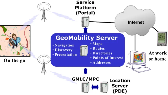
Figure 1 shows how the concept GeoMobility Server relates to the other elements of an LBS architecture. The GeoMobility server is an element offering basic functions on which location-based applications are built (the OpenLS Core Services). This server uses open interfaces to access network location capacity (provided through a GMLC, for instance) and provides a set of interfaces allowing applications hosted on this server, or on another server, to access the OpenLS Core Services (see definition of Core Services in section 9).
The GeoMobility Server also provides content such as maps, routes, addresses, points of interest, traffic, etc. It can also access other local content databases via the Internet.
In summary, the GeoMobility Server contains:
The Core Services and their OpenLS interfaces;
The OpenLS Information Model, consisting of ADTs;
Possibly, a set of local applications build upon the Core Services and accessing them through OpenLS interfaces;
Content such as map data, points of interest, routes, and so on used by the Core Services. This content can also be hosted on other servers and accessed through the Internet; and
9 OpenLS Core Services
The Core Services are location-based application services that form the Services Framework for the GeoMobility Server. See the associated standards for these services (this reference is listed in section 3).
The GeoMobility Server
•Geocode / Reverse Geocode
LIF
Figure 2. The GeoMobility Server
Note: It is not necessary to specify a Coordinate Reference System for Point geometries that are used by these services because the default for all coordinates used by the GeoMobility Server is WGS 84 as specified in the EPSG database. The coordinate conventions are as follows:
- Default Coordinate Reference System - WGS 84 (srsName=’4326’);
- Coordinate Order - Latitude, Longitude;
- Value Type - Decimal Degrees;
- Latitude Sign is +90 at North Pole to -90 at South Pole;
10 Navigation Service
10.1 Description of an Example
Use Case 1: The user wants to know: Which route should I take? The user has specified the endpoints, and optionally some waypoints, in some manner, or these points have been specified for the user. The starting point is either defined from a GPS or cellular network measurement or entered manually by the user. This information is then fed to a service that determines the route. Optionally, the user may specify route determination criteria. These criteria might be: fastest, shortest, least traffic, most scenic, etc. and can also specify the preferred mode of transport of the user. The routing algorithm might default to a single criterion, such as fastest. The route can also be optionally stored on the terminal or application server. The user may store it for as long as needed, thus requiring the means to also fetch a stored route.
10.2 Request and Response Parameters
10.2.1 Navigation DetermineRoute Request Parameters and Attributes
Determine Route Request Parameters
A collection of one or more of the parameters below
Name Mandatory? Data Type Description
RouteHandle Y (must
choose one of these two)
RouteHandleType Reference to a previously determined route. Used to request additional
information about the route, or to request an alternate route.
ExtendedRoutePlan RoutePlanType Specifies the criteria upon
which a new route is
determined [an extension of the base Route Service parameter].
BoundingBox N gml:EnvelopeType Rectangular area of route
for which the answer is requested. If not specified, defaults to full route.
turn-est equestType by-turn route instructions and travel advisories in a text, voice, or other presentation format.
FirstBucketSize N integer If not there, or zero, then
don't get first bucket, Else if some positive integer, then get that many objects in the first bucket.
Priority Y PriorityType Priority of the request (as
compared to other requests which need to be handled out of order).
provideRouteHandle N Boolean Requests the return of a
route handle.
Default = “false”
distanceUnit N DistanceUnitType
(UOM)
Specifies the unit for measuring distance.
RoutePlanType: Defines the criteria upon which a route is determined.
Name Mandatory Data Type Description
WayPointList Y RoutePointSequ
enceType
List of waypoints along the route. There must be at least two points, one for the origin and one for the destination. They are the first and the last point in this sequence. Intermediate waypoints, if there are any, are defined in the middle of the sequence.
AvoidList N AvoidListType
(ADT)
List of areas, locations, and features in which the route should avoid passing through.
ExtendedRouteControl Y RouteControlTy
pe
RouteControlType: This structure contains the criteria to be used by the DetermineRoute request:
The cost criteria includes the following information:
Should travel time or travel distance be minimized?
Should highways be used?
Should toll roads be used?
Should a scenic route be preferred?
For which vehicle type(s)?
For what starting and/or ending time?
Name Mandatory Data Type Description
CostCriteria Y RouteCostModel
Type
Cost Criteria
Vehicle N VehicleType Vehicle type(s)
VehicleCompositionL ogic
N string If more then one vehicle listed,
should they be considered as disjuncts or conjuncts (AND or OR)
RouteStartDateTime N DateTimeType Route “start” date and time
RouteEndDateTime N DateTimeType Route “end” date and time
useRealTimeTraffic N Boolean Specifies whether to use real
time traffic information when determining the best route.
10.2.2 Navigation Response Parameters Determine Route Response Parameters
A collection of one or more of the parameters below.
Name Mandatory Data Type Description
RouteLinkAndCost Y CursorType of type
RouteLinkAndCost
Here is returned an ordered list of links and node travel costs for the computed path. The computed path is the path for the specified compute control values in the request call
FirstBucket N CursorFetchResponse of
type RouteLinkAndCost
If we asked for 1st bucket to be returned in the Request
RouteHandle N RouteHandleType(ADT) Contains a reference to the
route stored at the Navigation Service server.
Can be used in subsequent requests to the Navigation Service to request additional information about the route, or to request an alternate route.
RouteSummary N RouteSummaryType
(ADT)
Describes the overall characteristics of the route.
ConstraintRelaxed N Boolean The ConstraintRelaxed output
parameter shows whether one or more RoutePlan (input parameter) values has been relaxed
WhichConstrainWas Relaxed
N Shows which constraint
11 OpenLS Information Model
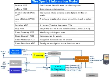
The OpenLS Core Services exchange content in the form of well-known OpenLS Abstract Data Types (ADTs). Collectively these ADTs comprise the OpenLS Information Model (Figure 3).
Turn-by-turn navigation instructions for a route Route Directions ADT
Navigation maneuver data for a route Route Maneuvers ADT
Geometry data for a route Route Geometry ADT
Metadata pertaining to a route Route Summary ADT
The portrayal of maps and feature overlays (routes & POI) Map ADT
A location (Position, Address or POI) Location ADT
A polygon, bounding box or circle used as a search template Area of Interest (AOI)
ADT
The location where someone can find place, product or service
Point of Interest (POI) ADT
Street address or intersection Address ADT
Point location in well-known coordinate system Position ADT
12 Conformance Requirements and Procedures
12.1 Compliance Testing
Compliance testing for this Implementation Standard shall be based upon the normative schema in Annex A.
The sponsors of this standard have devised the following conformance test requirements and procedures.
12.2 Abstract Test Suite
Annex A.1: OpenGIS Location Services (OpenLS) Navigation Service
Schema and Positioning Service (Normative)
The XML for Location Services (XLS) schema for Navigation Service, Version 1.3 is presented below.
nav-RouteService.xsd
<?xml version="1.0" encoding="UTF-8"?>
<!-- edited with XMLSpy v2008 sp1 U (http://www.altova.com) by Gil Fuchs (Tele Atlas) --> <!-- edited with XMLSpy v2006 sp1 U (http://www.altova.com) by Marwa Mabrouk (ESRI) --> <schema xmlns:gml="http://www.opengis.net/gml" xmlns:xls="http://www.opengis.net/xls"
xmlns:nav="http://www.opengis.net/ols/nav" xmlns="http://www.w3.org/2001/XMLSchema"
targetNamespace="http://www.opengis.net/ols/nav" elementFormDefault="qualified"
version="1.3">
<import namespace="http://www.opengis.net/gml" schemaLocation="GML4XLS.xsd"/> <import namespace="http://www.opengis.net/xls" schemaLocation="XLS.xsd"/>
<import namespace="http://www.opengis.net/xls" schemaLocation="RouteService.xsd"/> <include schemaLocation="nav-Positioning.xsd"/>
<include schemaLocation="nav-CursorUtil.xsd"/> <include schemaLocation="nav-UOM.xsd"/>
<!--Copyright (c) 2003 OGC, All Rights Reserved - This OGC document is a draft and is copyright-protected by OGC. While the reproduction of drafts in any form for use by participants in the OGC Interoperability Program is permitted without prior permission from OGC, neither this document nor any extract from it may be reproduced, stored or transmitted in any form for any other purpose without prior written permission from OGC.-->
<!-- ====================================== -->
<!-- DetermineRouteRequest --> <!-- ====================================== -->
<element name="DetermineRouteRequest" type="nav:DetermineRouteRequestType"
substitutionGroup="xls:_RequestParameters"/>
<complexType name="DetermineRouteRequestType"> <complexContent>
<extension base="xls:AbstractRequestParametersType"> <sequence>
<choice>
<element name="RouteHandle" type="xls:RouteHandleType"/> <element name="ExtendedRoutePlan" type="nav:RoutePlanType"/> </choice>
<documentation>Rectangular area of route for which the answer is requested. If not specified, defaults to full route.</documentation>
</annotation> </element>
<element name="RouteGuidanceRequest"
type="xls:RouteInstructionsRequestType" minOccurs="0"/>
<element name="FirstBucketSize" type="integer" minOccurs="0"> <annotation>
<documentation>If not there, or zero, then don't get first bucket, Else if some positive integer, then get that many objects in the first bucket.</documentation>
</annotation> </element> </sequence>
<attribute name="priority" type="nav:PriorityType" use="required"/> <attribute name="provideRouteHandle" type="boolean" use="optional"
default="false">
<annotation>
<documentation>Requests the return of a route handle.</documentation> </annotation>
</attribute>
<attribute name="distanceUnit" type="xls:DistanceUnitType" use="optional"
default="M">
<annotation>
<documentation>Specifies the unit for measuring distance.</documentation>
<complexType name="RoutePlanType"> <sequence>
<element name="WayPointList" type="nav:RoutePointSequenceType"> <annotation>
<documentation>There must be at least two points, one for the origin and one for the destination. They are the first and the last point in this sequence. Intermediate waypoints, if there are any, are defined in the middle of the sequence.</documentation>
</annotation> </element>
<element name="AvoidList" type="xls:AvoidListType" minOccurs="0"/> <element name="ExtendedRouteControl" type="nav:RouteControlType">
<annotation>
<documentation>The criteria upon which a route is determined.</documentation>
</sequence>
<attribute name="useRealTimeTraffic" type="boolean" use="optional" default="false"/> <attribute name="RelaxConstraint" type="boolean" use="required">
<annotation>
<documentation>The RelaxConstraint input parameter allows the caller to specify whether all the specified RoutePlan values must be met, or whether the called "agent" has
permission to relax one or more. If the specified RoutePlan values would result in no route being found because highways or toll roads are prohibited, then if RelaxConstraint is TRUE, the function may relax one or more RoutePlan prameters so that a route can be found. If the specified RoutePlan values do allow a result to be found, then RelaxConstraint has no effect.</documentation>
</annotation> </attribute> </complexType>
<complexType name="RoutePointSequenceType"> <annotation>
<documentation>Defines a list of waypoints along a route.</documentation> </annotation>
<sequence>
<element name="StartPoint" type="nav:RoutePointType"> <annotation>
<documentation>Starting point of the route.</documentation> </annotation>
</element>
<element name="ViaPoint" minOccurs="0" maxOccurs="unbounded"> <annotation>
<documentation>Intermediate waypoints along the route.</documentation> </annotation>
<complexType> <complexContent>
<extension base="nav:RoutePointType">
<attribute name="ordered" type="boolean" use="optional"
default="true">
<annotation>
<documentation>Unless otherwise specified, the ViaPoints are meant to be supplied in order</documentation>
</annotation>
<element name="EndPoint" type="nav:RoutePointType"> <annotation>
</element> </sequence> </complexType>
<complexType name="RoutePointType"> <annotation>
<documentation>contains a set of link loci associated with a single route point.</documentation>
</annotation> <sequence>
<element name="LinkLoci" type="nav:LocusType" maxOccurs="unbounded"/> </sequence>
</complexType>
<complexType name="RouteControlType"> <annotation>
<documentation>This structure contains the criteria to be used by the DetermineRoute request:
The cost criteria includes the following information: -- Should travel time or travel distance be minimized? -- Should highways be used?
-- Should toll roads be used?
-- Should a scenic route be preferred? For which vehicle type(s)?
For what starting time?</documentation> </annotation>
<sequence>
<element name="CostCriteria" type="nav:RouteCostModelType"> <annotation>
<documentation>Cost criteria</documentation> </annotation>
</element>
<element name="Vehicle" type="nav:VehicleType.N" minOccurs="0"
maxOccurs="unbounded"> <annotation>
<documentation>Vehicle type(s)</documentation> </annotation>
</element>
<element name="VehicleCompositionLogic" minOccurs="0"> <annotation>
<documentation>If more then one vehicle listed, should they be considered as disjuncts or conjuncts</documentation>
</annotation> <simpleType>
<restriction base="string">
</simpleType> </element>
<element name="RouteStartDateTime" type="nav:DateTimeType" minOccurs="0"> <annotation>
<documentation>Route start date and time.</documentation> </annotation>
</element>
<element name="RouteEndDateTime" type="nav:DateTimeType" minOccurs="0"/> </sequence>
<attribute name="useRealTimeTraffic" type="boolean" default="false"> <annotation>
<documentation>Specifies whether to use real time traffic information when determining the best route.</documentation>
</annotation> </attribute> </complexType>
<complexType name="RouteCostModelType"> <annotation>
<documentation>This structure contains information about the cost criteria. It contains information about how to assign "exchange rate" cost to:
-- Road distance -- Road travel time
-- Highway usage preference -- Toll road usage preference
-- Scenic route preference</documentation> </annotation>
<sequence>
<element name="MinimizerGoal" type="nav:RouteMinimizeOptionEnum"/> <element name="HighwayAffinity" type="nav:RouteHighwayUsageEnum"
minOccurs="0"/>
<element name="TollroadAffinity" type="nav:RouteTollUsageEnum"
minOccurs="0"/>
<!--<element name="ScenicRoute" type="boolean" minOccurs="0"/>--> </sequence>
<attribute name="ScenicRoute" type="boolean" use="optional"/> </complexType>
<!-- ====================================== --> <!-- DetermineRouteResponse -->
<!-- ====================================== -->
<element name="DetermineRouteResponse" type="nav:DetermineRouteResponseType"
substitutionGroup="xls:_ResponseParameters"/>
<complexType name="DetermineRouteResponseType"> <annotation>
</annotation> <complexContent>
<extension base="xls:AbstractResponseParametersType"> <sequence>
<element name="RouteLinkAndCost" type="nav:CursorType"> <annotation>
<documentation>Here is returned an ordered list of links and node travel costs for the computed path. The computed path is the path for the specified compute control values in the request call.</documentation>
</annotation> </element>
<element name="FirstBucket" type="nav:CursorFetchResponse"
minOccurs="0"/>
<element ref="xls:RouteHandle" minOccurs="0"/> <element ref="xls:RouteSummary" minOccurs="0"/>
<element name="ConstraintRelaxed" type="boolean" minOccurs="0"> <annotation>
<documentation>The ConstraintRelaxed output parameter shows whether one or more RoutePlan (input parameter) values has been relaxed. </documentation>
</annotation> </element>
<element name="WhichConstrainWasRelaxed" minOccurs="0"/> </sequence>
</extension> </complexContent> </complexType>
<complexType name="RouteLinkAndCost"> <sequence>
<element name="Link" type="nav:AbstractIDType"/>
<element name="EstLinkTravelTime" type="unsignedLong"> <annotation>
<documentation>Link traversal time, in tenths of seconds.</documentation> </annotation>
</element>
<element name="NodeTravelTime" type="unsignedShort"> <annotation>
<documentation>Estimated node travel cost to the link above, units of measurement are in tenths of seconds.</documentation>
nav-Positioning.xsd
<?xml version="1.0" encoding="UTF-8"?>
<!-- edited with XMLSPY v2004 rel. 3 U (http://www.xmlspy.com) by Gil Emanuel Fuchs (Tele Atlas) -->
<!--Generated by XML Authority. Conforms to w3c http://www.w3.org/2001/XMLSchema--> <xsd:schema xmlns:xsd="http://www.w3.org/2001/XMLSchema"
xmlns:gml="http://www.opengis.net/gml" xmlns:xls="http://www.opengis.net/xls"
xmlns:nav="http://www.opengis.net/ols/nav" targetNamespace="http://www.opengis.net/ols/nav"
elementFormDefault="qualified" version="1.3">
<xsd:import namespace="http://www.opengis.net/gml" schemaLocation="GML4XLS.xsd"/> <xsd:import namespace="http://www.opengis.net/xls" schemaLocation="XLS.xsd"/>
<xsd:include schemaLocation="nav-CursorUtil.xsd"/> <xsd:include schemaLocation="nav-UOM.xsd"/>
<!-- ====================================== --> <!-- Positioning functions -->
<!-- ====================================== -->
<xsd:element name="GetPositionRequest" type="nav:GetPositionRequestType"
substitutionGroup="xls:_RequestParameters"/>
<xsd:element name="GetPositionResponse" type="nav:GetPositionResponseType"
substitutionGroup="xls:_ResponseParameters"/>
<xsd:element name="GetNearbyMapObjRequest" type="nav:GetNearbyMapObjRequestType"
substitutionGroup="xls:_RequestParameters"/>
<xsd:element name="GetNearbyMapObjResponse"
type="nav:GetNearbyMapObjResponseType" substitutionGroup="xls:_ResponseParameters"/> <xsd:complexType name="GetPositionRequestType">
<xsd:complexContent>
<xsd:extension base="xls:AbstractRequestParametersType"> <xsd:sequence>
<xsd:element name="UseHistory" type="xsd:boolean"/>
<xsd:element name="CurrentPosition" type="xls:PositionType"/> </xsd:sequence>
<xsd:attribute name="priority" type="nav:PriorityType" use="required"/> </xsd:extension>
</xsd:complexContent> </xsd:complexType>
<xsd:complexType name="GetPositionResponseType"> <xsd:complexContent>
<xsd:extension base="xls:AbstractResponseParametersType"> <xsd:sequence>
<xsd:element name="Locus" type="nav:LocusType"/> </xsd:sequence>
<xsd:complexType name="GetNearbyMapObjRequestType"> <xsd:complexContent>
<xsd:extension base="xls:AbstractRequestParametersType"> <xsd:sequence>
<xsd:element name="CurrentPosition" type="xls:PositionType"/> <xsd:element name="Delta" type="xsd:unsignedLong"/>
<xsd:element name="GetFirstBucket" type="xsd:integer" default="0"
minOccurs="0">
<xsd:annotation>
<xsd:documentation>If not there, or zero, then don't get first bucket, Else if some positive integer, then get that many objects in the first bucket.</xsd:documentation>
</xsd:annotation> </xsd:element> </xsd:sequence>
<xsd:attribute name="priority" type="nav:PriorityType" use="required"/> </xsd:extension>
</xsd:complexContent> </xsd:complexType>
<xsd:complexType name="GetNearbyMapObjResponseType"> <xsd:complexContent>
<xsd:extension base="xls:AbstractResponseParametersType"> <xsd:sequence>
<xsd:element name="MapObj" type="nav:MapObjType"/> </xsd:sequence>
</xsd:extension> </xsd:complexContent> </xsd:complexType>
<xsd:complexType name="MapObjType"> <xsd:sequence>
<xsd:element name="Cursor" type="nav:CursorType"/>
<xsd:element name="FirstBucket" type="nav:CursorFetchResponse" minOccurs="0"/> </xsd:sequence>
</xsd:complexType>
<xsd:complexType name="LocusType"> <xsd:complexContent>
<xsd:extension base="xls:AbstractWayPointType"> <xsd:sequence>
<xsd:element name="Link" type="nav:AbstractIDType"/> <xsd:element name="PositionAlongLink" minOccurs="0">
<xsd:simpleType>
<xsd:restriction base="nav:FractionType"> <xsd:minInclusive value="0"/>
<xsd:maxInclusive value="1"/> </xsd:restriction>
<xsd:element name="Side" minOccurs="0"/> </xsd:sequence>
nav-CursorUtil.xsd
<?xml version="1.0" encoding="UTF-8"?>
<!-- edited with XMLSPY v2004 rel. 3 U (http://www.xmlspy.com) by Gil Emanuel Fuchs (Tele Atlas) -->
<!--Generated by XML Authority. Conforms to w3c http://www.w3.org/2001/XMLSchema--> <schema xmlns="http://www.w3.org/2001/XMLSchema"
xmlns:xsd="http://www.w3.org/2001/XMLSchema" xmlns:xls="http://www.opengis.net/xls"
xmlns:nav="http://www.opengis.net/ols/nav" targetNamespace="http://www.opengis.net/ols/nav"
elementFormDefault="qualified">
<import namespace="http://www.opengis.net/xls" schemaLocation="XLS.xsd"/> <include schemaLocation="nav-UOM.xsd"/>
<!-- ====================================== --> <!-- Large Result Set Utilities (requests) -->
<!-- ====================================== --> <complexType name="CursorFetchRequest">
<annotation>
<documentation>get a bucket from the cursor (of requested size)</documentation> </annotation>
<complexContent>
<extension base="xls:AbstractRequestParametersType"> <sequence>
<element name="CursorID" type="nav:CursorIDType"/>
<element name="FetchDirection" type="nav:FetchDirectionType"/> <element name="NumRecordsToFetch" type="xsd:unsignedLong"/> </sequence>
<attribute name="priority" type="nav:PriorityType" use="required"/> </extension>
</complexContent> </complexType>
<complexType name="GetCursorInfoRequest"> <complexContent>
<extension base="xls:AbstractRequestParametersType"> <sequence>
<element name="CursorID" type="nav:CursorIDType"/> </sequence>
<attribute name="priority" type="nav:PriorityType" use="required"/> </extension>
</complexContent> </complexType>
<complexType name="GetCursorPositionRequest"> <annotation>
records. If there are N records in total, gap number N is the gap after the last record. The value returned by this request is the current cursor position.</documentation>
</annotation> <complexContent>
<extension base="xls:AbstractRequestParametersType"> <sequence>
<element name="CursorID" type="nav:CursorIDType"/> </sequence>
<attribute name="priority" type="nav:PriorityType" use="required"/> </extension>
</complexContent> </complexType>
<complexType name="SetCursorPositionRequest"> <annotation>
<documentation>This request positions a large result set cursor current position (CP) to a specified record within the complete result set. The action of this request can be described in two steps as follows, although there is no implication that the actual implementation of the request must be implemented in this way: First, if the “CursorStartPosition” element is RESULT_SET_START, the CP is moved to the gap before the first record; if the “CursorStartPosition” element is
RESULT_SET_END, the CP is moved to the gap after the last record; and if the
“CursorStartPosition” element is CURRENT_POSITION, the CP is not moved. Second, if NumOfPositions is positive, the CP is moved forward (toward the end of the result set) by NumOfPositions records; if NumOfPositions is negative, the CP is moved backward (toward the beginning of the result set) by NumOfPositions records; if NumOfPositions is zero, the CP is not moved. However, if this movement would move the CP before the gap at the beginning of the large result set or after the gap at the end of the large result set, the CP is instead left at that gap.
</documentation> </annotation> <complexContent>
<extension base="xls:AbstractRequestParametersType"> <sequence>
<element name="CursorID" type="nav:CursorIDType"/>
<element name="CursorStartPosition" type="nav:CursorOriginEnum"/> <element name="NumOfPositions" type="xsd:long" default="0"/> </sequence>
<attribute name="priority" type="nav:PriorityType" use="required"/> </extension>
</complexContent> </complexType>
<complexType name="ProcessCursorRequest"> <annotation>
<documentation>This request is for the server to process all of the records in the result set starting with the first record regardless of where the cursor's current position is currently
The action function’s first parameter is a pointer to a structure of the type contained in the cursor's records. The second is an application-defined structure, or NULL. In processing each cursor element, the third element of ProcessCursorRequest is passed in as the second argument of ActionFunc. If ActionFunc yields a negative result value, processing will be aborted. ProcessCursorResponse returns the number of records processed.</documentation>
</annotation> <complexContent>
<extension base="xls:AbstractRequestParametersType"> <sequence>
<element name="CursorID" type="nav:CursorIDType"/> <element name="ActionFunc" type="xsd:anyType"/> <element name="ActionFuncParam" type="xsd:anyType"/> </sequence>
<attribute name="priority" type="nav:PriorityType" use="required"/> </extension>
</complexContent> </complexType>
<complexType name="CloseCursorRequest"> <complexContent>
<extension base="xls:AbstractRequestParametersType"> <sequence>
<element name="CursorID" type="nav:CursorIDType"/> </sequence>
<attribute name="priority" type="nav:PriorityType" use="required"/> </extension>
</complexContent> </complexType>
<!-- ====================================== --> <!-- Large Result Set Utilities (responses) -->
<!-- ====================================== --> <complexType name="CursorFetchResponse">
<complexContent>
<extension base="xls:AbstractResponseParametersType"> <sequence>
<element name="NumFetchedRecords" type="long"> <annotation>
<documentation>How many records actually got returned.</documentation>
</annotation> </element>
<element name="CursorType" type="nav:CursorTypeEnum"/> <element name="RetrievedRecords" type="xsd:anyType"
</complexType>
<complexType name="GetCursorInfoResponse"> <complexContent>
<extension base="xls:AbstractResponseParametersType"> <sequence>
<element name="CursorInfo" type="nav:CursorInfoType"/> </sequence>
</extension> </complexContent> </complexType>
<complexType name="GetCursorPositionResponse"> <complexContent>
<extension base="xls:AbstractResponseParametersType"> <sequence>
<element name="CursorPosition" type="xsd:long"/> </sequence>
</extension> </complexContent> </complexType>
<complexType name="SetCursorPositionResponse"> <complexContent>
<extension base="xls:AbstractResponseParametersType"> <sequence>
<element name="GapNum" type="long"> <annotation>
<documentation>the number of the gap at which the cursor is left</documentation>
<complexType name="ProcessCursorResponse"> <complexContent>
<extension base="xls:AbstractResponseParametersType"> <sequence>