ISSN: 2339-076X, Volume 2, Number 2 (January 2015): 289 - 294
DOI:10.15243/jdmlm.2014.022.289
Research Article
Controlling conservation functions of peat lands at Langgam District,
Pelalawan Regency of Riau Province
P. Astuti
*, C.A. Bintang
Department of Urban and Regional Planning, Engineering Faculty - Islamic Riau University Kaharuddin Nasution Street #113, Pekanbaru 28284 - Indonesia
*
corresponding author: [email protected]
Abstract:
Forest fires in Langgam District, Pelalawan Regency of Riau Province is caused environmental damage which impact on many aspects, especially the social and economic. This study was aimed to identify the natural environment, the impact of deforestation and land, and the potential problems to the spatial environment and to manage of land conservation and the environment. The methodology used in this study-included quantitative analysis with interviews, GIS spatial analysis and qualitative analysis. Results of this study indicated that the destruction of forests covering about 45.71% of total land in Riau Province was peat land. Sixty six percent of the destruction was directed to the use of land and forest production. There were 11 fire spots in the Langgam District. Results of SWOT analysis indicated non-integrated the estate management, lack of coordination among stakeholders, non-integrated institutional management and forestry and plantations, lack of budget, large illegal logging and land conversion made by private and public institutions.Keywords:environmental, conservation, degradation, peat land, spatial
Introduction
Riau Province became one of the interesting issues to be discussed. This is caused by many factors including land use as it did in Pelalawan, Riau Province. Forest conversion causes environmental damage because of forest fires that occur continuously. This will have an impact on many aspects, especially the social and economic (Anwar et al., 1984). Even from this impact is not only about the disadvantaged communities but also about the wider community beyond the local community affected by the effects of smoke pollution caused by peat fires (Warman, 2011).
For that, we need to pay attention to these environmental benefits to be gained by maintaining the presence of each component of the environment for future utilization, known as conservation. Conservation to preserve, maintain and preserve something of the built environment and the natural environment, such as protection against natural disasters, river conservation and natural scenery, environmental conservation needs to be done to peat lands in Langgam District as vulnerable peat forest fires. According to Rijksen
(1981), conservation is a form of cultural evolution in which conservation can be seen in the economic and ecological conservation economically which means trying to allocate resources for now, while the ecological conservation of a natural resource allocation for the present and future. Conservation is an environmental conservation effort but still consider the benefits gained at that time while maintaining the presence of each component of the environment for future utilization.
According to Law no. 4 in 1982, the conservation of natural resources is a form of natural management to ensure prudent utilization of renewable resources and to ensure continuity of supply while maintaining and enhancing the value and diversity. The national conservation strategy has been formulated into the following three implementations:
controlling LBPS for maximum exploitation in LBPS waters.
2. Preservations of plants, animals, and their ecosystems that includes preservation of plant animal diversity 3. Sustainable use of biological resources
and ecosystems that require the utilization of a nature conservation area of environmental conditions, and the use of plants and wildlife.
This study was aimed to identify the natural environment, the impact of deforestation and land, and the potential problems to the spatial environment and to manage of land conservation and the environment of Langgam District, Pelalawan Regency of Riau Province.
Material and Methods
The method used for this study was descriptive quantitative method to create a description of the situation or event, to explain the relationship between phenomena, and to make predictions and get the meaning and implications of a problem to be solved. This study was conducted by observing a case study on the Langgam District, Pelalawan Regency. Identification of field conditions of land use was done by identifying the mapping technique through analysis of aerial photographs of the study area supported with observation data as well as other supporting data. Methods used for this study were similar to those used by Yoza (2013) and Yusuf (2013). Summary of the method is presented in Table 1.
Table 1. Research Method
Target Variable Method
Identification of forest and peat land destruction
Area of peat land Degraded peat lands
Descriptive Analysis and Qualitative Analysis of GIS through secondary data and field observations
Identification of land conservation Problems Potential Opportunities Challenge
Descriptive analysis through field observations
Strategies of land conservation and environmental
Output targets 1 and 2 Descriptive qualitative interviews
Result and Discussion
Destruction of forests and peat lands
Peat area is an area with soil forming elements of mostly organic material that are buried for a long time. Under the Act no.26 of 2007 on Spatial Planning, Government Regulation no.26 of 2008 on National Spatial Plan states that peat areas are protected areas that provide as conservation area.
The protection of peat is intended to control hydrology of the region that serves as a mooring water and prevention of water, as well as protecting the unique ecosystem of the concerned region. Peat region is defined by the criteria of 3 meters or more that were found in all districts, especially that of districts in Pelalawan Regency. The total peat land area in Pelalawan regency is 4,105,242 ha or 45.71% of the total land in the Province of Riau (Table 2 and Figure 1). This conditions describe Riau has high vulnerability to ecological disaster. This is because the characteristics of peat:
1. The ability to store water 15-20 times the
2. Hydrophobicity/dry so prone to fires.
3. The ability of removing water toward greater horizontal than the vertical so dry and flammable.
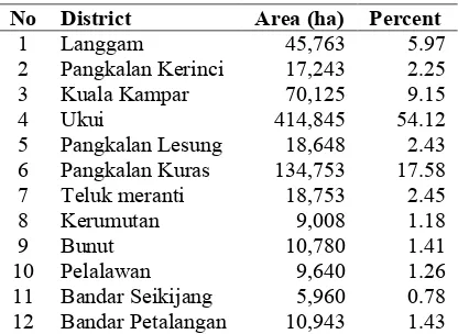
Table 2. Peat areas at Pelalawan Regency
No District Area (ha) Percent
1 Langgam 45,763 5.97
2 Pangkalan Kerinci 17,243 2.25 3 Kuala Kampar 70,125 9.15
4 Ukui 414,845 54.12
5 Pangkalan Lesung 18,648 2.43 6 Pangkalan Kuras 134,753 17.58 7 Teluk meranti 18,753 2.45
8 Kerumutan 9,008 1.18
9 Bunut 10,780 1.41
Rate of forest degradation
Analysis of the results showed that natural forest in Riau, especially which in Pelalawan Regency has entered a critical phase with the rate of degradation of 100,000 ha/year. Based on the results of the study, 50% of total peat lands were no longer forested as on Riau RTRWP because it has been converted to aquaculture activities. Currently there is only 22.9% of the land area of Riau is converted by natural forest. Data presented in Figure 1 show that degradation would occur around 17.87% of the land area of Riau will be converted for the purpose of cultivation or about 5.13% of the land area in Riau that will be left.
Use of industrial plant forest
Based on data of Jikalahari (2012), 66% of the area is directed to the use of production forest, and the remaining 23.64% is for the plantation (Table 3).
Table 3. Land use in Riau
No Land Use Area
(Ha)
Percent (%) 1 Fixed production
forest areas
1,457,379 66.87%
2 Plantation / annual plant areas
525, 294 23.64%
3 Plantation areas and others
43, 250 1.98%
4 Agricultural areas
163, 254 7.49%
5 Industrial areas 275 0.01% Source: Jikalahari (2012)
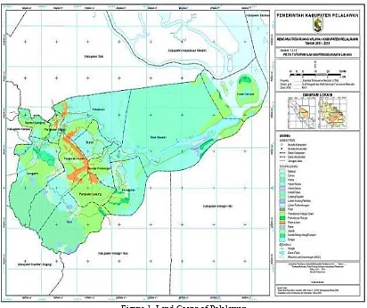
Data presented in Table 3 show that the licensing of Industrial Plantation Forest has relatively high portion. This led to massive forest fires that occurred in Langgam District, Pelalawan Regency of Riau Province. Pelalawan land cover map is presented in Figure 1.
Distribution of forest fires
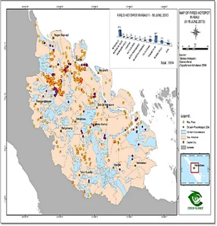
Peat land areas that are susceptible to forest fire are located in the Langgam, Ukui, Pangkalan Lesung, Bunut, Pelalawan, Kuala Kampar, Kerumutan, Teluk Meranti, Bandar Seikijang, and Bandar Petalangan Districts. Environmental issues related to forests are forest fires that cause of smog. Potential prone of forest fire forests or peat lands that cause smog are primarily concerned with land clearing by burning, and fires on forest/peat in the downstream region. Conversion of peat land in large scale caused some area at Langgam District became fire spots. Results of
observation showed 11 spots comprising 2 spots at Segati Village, 3 spots at Sotol Village, 1 spot at Tambak Village, 2 spots at Langkan Village, 1 spot at Penarikan Village, and 3 spots at Langgam Village (Figure 2).
Land conservation
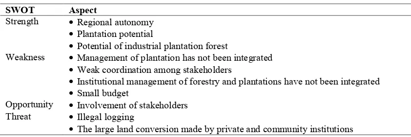
Based on the results of the research with interviews and secondary data collection, SWOT analysis (Strength, Weakness, Opportunity, Threat) of Langgam District is presented in Table 5.
Table 5. Identification of land conservation at Langgam District
SWOT Aspect
Strength Regional autonomy
Plantation potential
Potential of industrial plantation forest
Weakness Management of plantation has not been integrated
Weak coordination among stakeholders
Institutional management of forestry and plantations have not been integrated
Small budget
Opportunity Involvement of stakeholders Threat Illegal logging
The large land conversion made by private and community institutions
Land and environmental conservation
strategies
Based on the results of the study by combining field observations and secondary data, strategies of controlling land and environmental conservation are as follows:
1. Establishing integrated conservation area at Laggam District through the Spatial Plan by incorporating elements of peat land studies as a protected area.
2. Reviewing the use of Industrial Plantation Forest area contained in the Spatial Plan which particular plantation forest industry including peat.
3. Conducting control measures of conservation areas by implementing integrated planning stages, management, rehabilitation which includes natural regeneration, artificial natural regeneration, reforestation using native trees, commercial reforestation, community-based reforestation and agroforestry and community-based conservation stages.
4. Management, regulation and licensing of forestry.
5. Preparation of legislation in conservation planning and industrial plantation forest in the form of regulations, Decree, etc.
6. Integration of forest management between stakeholders.
Conclusion
1. Forest destruction covered about 45.71% of total land of Riau Province; 66% of the area was directed to the use of land and forest production. There were 11 fire spots in the Langgam District comprising 2 spots at Segati Village, 3 spots at Sotol Village, 1 spot at Tambak Village, 2 spots at Langkan
Village, 1 spot at Penarikan Village, and 3 spots at Langgam Village.
2. Results of SWOT analysis indicated non-integrated the estate management, lack of coordination among stakeholders, non-integrated institutional management of forestry and plantations, small budget, large illegal logging and land conversion made by private and community institutions.
3. Conservation area control strategy needs to be developed to minimize the impact of forest fires caused by land conversion in Riau Province.
Acknowledgements
The authors thank the Organizing Committee of the 2014 Land Degradation Workshop of Mataram University for correcting this manuscript
References
Anwar, J., Damanik, S.J., Hisyam, N. dan Whitten, A.J. 1984. Ekologi Ekosistem Sumatra. Gadjah Mada University Press. Jogyakarta. p 245-251.
BPS-Kabupaten Pelalawan. 2013. Pelalawan in Figure 2013. Catalog BPS : 1102001.1404.
Jikalahari (Jaringan Kerja Penyelamat Hutan Riau). 2012. Documents of Regional Spatial Plan Riau Province.
Pangkalan Kerinci District of Kabupaten Pelalawan Regency. 2007. RDTR Kecamatan Pangkalan Kerinci tahun
Pemerintah Kabupaten Pelalawan, 2011. RTRW Kabupaten Pelalawan (RIAU), Laporan Rencana, 2011-2021
Rijksen, H.D. 1981. Infant killing; a possible consequence of a disputed leader role. Behaviour
78: 138–168.
Warman, A. 2011. Regional Planning in Langgam District of Pelalawan Regency. Departement Urban and Regional Planning, Islamic University of Riau. Yoza, D.. 2013. Mode Penentuan Daerah Rawan
Informasi Geografis (SIG) Berdasarkan Kriteria Fisik Lingkungan dan Sosial Ekonomi Masyarakat Kabupaten Rokan Hilir Riau. Prosiding Seminar Nasional Konservasi dan Proteksi Lingkungan. 14 Desember 2013. Pangeran Hotels. Pekanbaru. p 289-303.