STATE OF MBEGANI BAY
The Ecosystem, Livelihoods and Future Status
Bagamoyo District
September 2013
This publication is available electronically on the Coastal Resources Center’s website at http://www.crc.uri.edu. For more information contact: Coastal Resources Center, University of Rhode Island, Narragansett Bay Campus, South Ferry Road, Narragansett, Rhode Island 02882, USA. Visit: www.crc.uri.edu. Tel: (401) 874-6224; Fax: (401) 874-6920.
Citation: Tobey, J., Robadue, D., Shaghude, Y.W., Muhando, C., Kalangahe, B., Mahenge, J., Daffa, J. (2013). State of Mbegani Bay: The Ecosystem, Livelihoods, and Future Status, Tanzania. Coastal Resources Center, Graduate School of Oceanography, University of Rhode Island, Narragansett, RI, 49 pp.
Disclaimer: This report is made possible by the generous support of the American people through the United States Agency for International Development (USAID). The contents are the responsibility of the Coastal Resources Center at the University of Rhode Island as part of the USAID/Pwani Project. Cooperative Agreement No. 621-A-00-10-00012-00.
Cover Photo: Beach resort on Mbegani Bay
PREFACE
The coastline of Bagamoyo District stretches from Mpiji River in the south that marks a border with Dar es Salaam to Mligaji River in the north bordering Pangani District. This area is endowed with a bounty of diverse natural resources that supports the livelihoods of
communities. However, the coastal resources have come under increasing pressure over the past three decades. This has led to a significant decline in the biodiversity and productivity of coastal and marine resources. Pressures are both anthropogenic and non-anthropogenic with leading anthropogenic pressures including population growth, poorly planned development, resource over-exploitation, and destructive fishing practices.
There are hotspots dotting the coastline of Bagamoyo that are of both economic and biological significance. One of these hotspots is Mbegani Bay. The Bay has a number of reefs, estuaries, seagrass beds and mangrove ecosystems that provide important habitat to marine organisms and as a result, it is home to a highly productive fishery. The Bay also includes a lagoon that provides a buffer against ocean surf, protecting the shore and coastal settlements.
The natural endowments have attracted diverse interests, which seek to take advantage of the biological and economic importance of the Bay. At one end of the spectrum are those with an interest to conserve the natural resource base and ecological amenities of the Bay so that the resources are kept in good condition and are sustainably utilized. At the other extreme are interests for turning the Bay and the surrounding area into a satellite industrial center that supports a range of economic investments, including an industrial port.
It is in recognition of this diversity of interests that the Pwani Project has decided to produce this document. It aims to identify pertinent issues related to the Bay and its environs and it seeks to inform all stakeholders on the physical, biological and socio-economic status of the Bay ecosystem. It further presents scenarios of the future status of the bay, policies, and actions to achieve desired future goals and objectives.
Table of Contents
EXECUTIVE SUMMARY ... 1
1. INTRODUCTION... 3
2.1 The Hydrology and Functioning of Mbegani Bay 4
2.2 Shoreline Changes and Human Influence 6
3. ECOSYSTEM CHARACTERISTICS... 8
3.1 Mangroves 8
3.2 Seagrass 10
3.3 Coral Reefs 12
3.4 The Ruvu Delta and its influence on Mbegani Bay 15
4. LIVELIHOODS THAT DEPEND ON THE MBEGANI BAY MARINE
ECOSYSTEM ... 18
4.1 Artisanal Fishing 19
4.2 Mariculture 21
4.3 Ecotourism and Cultural/Historic Tourism 24
4.4 National Development Plans for Mbegani Bay 27
4.5 Other Livelihood and Development Issues 29
5. GOVERNANCE SYSTEMS AND CONSERVATION EFFORTS ... 31
5.1 Local Governance Structure 31
5.2 Ongoing coastal governance efforts relevant to Mbegani Bay 32
6. SCENARIOS FOR MBEGANI BAY’S FUTURE ... 36
SCENARIO 1 - Bay conservation through stagnation: No investment plus urban sprawl 36
SCENARIO 2 - Slow transformation of the Bay: Low port and limited special economic
zone investment 37
SCENARIO 3 - Rapid transformation of the Bay: Port Authority “Baseline” port
investment and flourishing economic zone 37
SCENARIO 4 –The Balanced Use “Bay”: Strong implementation of environmental and social best practices through stakeholder vigilance and negotiation 38
The Way Forward 39
7. CONCLUSIONS ... 41
List of Figures
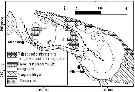
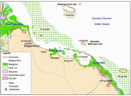
Figure 1 Map showing Mbegani Bay area and mangrove ecosystems ... 4
Figure 2 Map showing the bathymetry of the Mbegani Bay. Note the two tidal channels which merge on the southeastern part of the Bay (Source : Shaghude, 2011.) ... 5
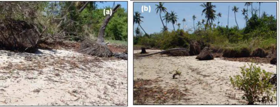
Figure 3 Eroding shore at Mbegani as exemplified by the uprooting of trees and collapse of the beach cliff. (Source: Shaghude 2011). ... 6
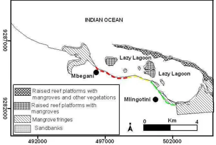
Figure 4 Map showing the status of coastal erosion along the western coastal stretch of Mbegani Bay stretching between Mbegani and Mlingotini ... 7
Figure 5 Map showing the distribution and estimated area cover of seagrass in Mbegani Bay area ... 10
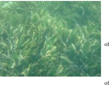
Figure 6 Seagrass bed ... 11
Figure 7 The distribution and management status of coral reefs in the Mbegani Bay area (Source Muhando, 2006) ... 13
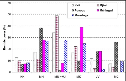
Figure 8 Between site comparison of the main reef benthic categories in 2006 ... 15
Figure 9 A map showing the Ruvu River drainage basin, which extends as far as Uluguru mountains. ... 16
Figure 10 A map showing the Ruvu-Wami prawn trawling area. (Source: Muhando and Rumisha 2008) ... 17
Figure 11 Salt flats suitable for mariculture and the location of current fish ponds in the Mbegani Bay area ... 23
Figure 12 The Mlingotini Information Center and signboard ... 24
Figure 13 Kaole Ruins ... 24
Figure 14 Anglican Church ... 25
Figure 15 Proposed Channel layout for the Bagamoyo Port Development at Ras Mbegani (Source: TPA, 2011) ... 28
Figure 16 Mbegani Bay and surrounding area of influence showing location of fish no-take sites (source: Muhando, 2006) ... 34
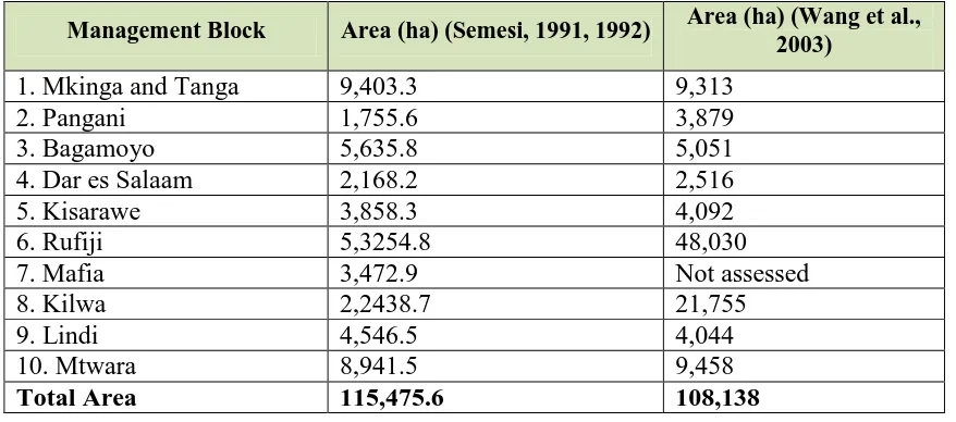
List of Tables Table 1. Mangrove forest area cover change in ten blocks along the coast of mainland Tanzania ... 8
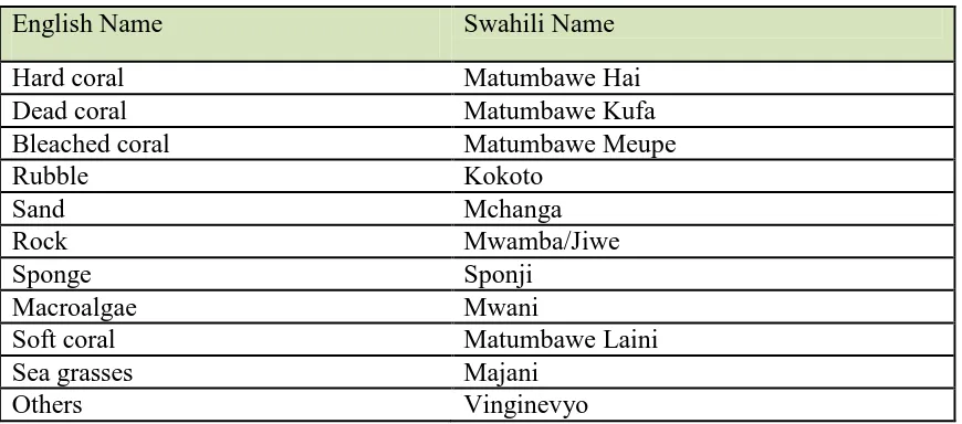
Table 2. Reef benthic variables monitored ... 9
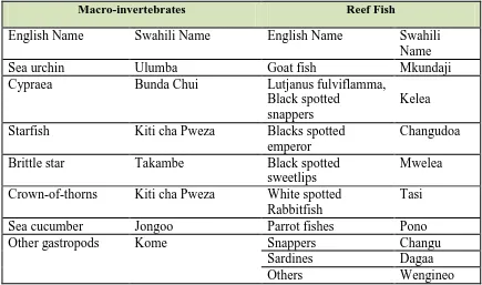
Table 3. Reef macro-invertebrates and reef fish monitored ... 14
Table 4. Bagamoyo District population in 2002 and projected growth by 2011 ... 18
Table 5. Fisheries information relevant to the Mbegani Bay area ... 19
Table 6. Perceptions of change wihtin fisheries among Mbegani Bay communities ... 20
Table 7. Services and infrastructure at fish landing sites... 20
Table 8. Salt flats suitable for mariculture and the location of current fish ponds in the Mbegani Bay area ... 22
EXECUTIVE SUMMARY
The focus of this report is Mbegani Bay area which is defined as extending northward to Dunda village and southward to Kondo Village. However, understanding the influence of the surrounding ecosystem there is also rich information covering as far as the Ruvu River
estuary. This area administratively falls under two administrative Divisions: Yombo and Mwambao. Each of these Divisions has two wards, and thus there are a total of four Wards (Zinga, Kerege, Magomeni and Dunda) that have a direct influence on the Bay area. In this area there are seven coastal villages that frequently use and directly influence the ecosystem: Mlingotini, Kondo, Pande, Kaole, Dunda, Magomeni and Makurunge (through its hamlets of Kitame and Razaba). Adjacent inland villages, including Mapinga and Zinga, also use and influence the Bay.
People in the Mbegani Bay area rely predominantly on natural resources and ecological services for their livelihoods. Thus the ecological integrity and productivity of the marine ecosystem is critical to the resilience of the larger Bay population. Mangroves protect the shoreline from erosion and eliminate contaminants from terrestrial run-off. There are extensive seagrass beds in the Bay area that are highly productive and are high in species diversity and abundance. They are a valuable fish nursery and habitat for numerous marine species. If managed well it has the potential for becoming a fish aggregation site. Coral reefs together with the seagrass beds are very important for the fisheries sub-sector. In terms of preferred fishing locations, most of the fishing (perhaps up to 70%) takes place on seagrass beds located adjacent to coral reefs. Due to the freshwater flow and extensive mangrove areas of the Ruvu and Wami rivers, the second most important prawn fishing ground in Tanzania is found in the Mbegani Bay area and northwards. The condition and status of shorelines, mangroves, seagrass, coral reefs, and estuaries are described in detail in this report.
The livelihoods that these ecosystems support are also described. They include fisheries (about 50% of people in villages are fishers and/or farmers), ecotourism, seaweed farming and fish farming. Ecotourism and beach hotels in Mbegani Bay area rely on the natural endowments of the beach and sea as well as the cultural and historic amenities in this area. These unique and invaluable amenities are historically tied to the natural features of the Mbegani Bay area.
The mangroves, seagrass beds, and ecological functioning of the Ruvu estuary are found to be in relatively good condition. The coral reefs and fisheries are not in good condition and require greater conservation effort, monitoring and surveillance to reverse the trend to further degradation.
There have been many government, civil society and donor project efforts focused on conservation and coastal management around Mbegani Bay. For example, at the District level, in the last decade there have been Intgrated Coastal Mangmeent (ICM) Action Plans, Collaborative Fisheries Management planning and the designation of no-take zones in four reefs in the Mbegani Bay area, Mariculture Zoning at the District level, and Eco-tourism planning both in Dunda and Mlingotini. In addition, in Mlingotini Village, the Msichoke Seaweed Farmers Community Based Organization has been active in seaweed farming planning and management in Mlingotini Bay.
area under special protection from destructive development and uses. Nor does the District have its own spatial zoning plan that defines what local stakeholders would like to see as the road map that puts limits on the location and intensity of future development and mandates conservation areas.
A set of scenarios is presented that can be used to highlight the need to establish a solid, transparent process for development decision making in Bagamoyo so that outcomes in 2030 meet the aspirations of residents while avoiding their fears and allaying their concerns. The four scenarios include:
1. “Business as usual”;
2. “Slow transformation with low port with limited special economic zone investment,”
3. “Rapid transformation with flourishing economic zone.” and
1. INTRODUCTION
The Pwani project is a partnership between the University of Rhode Island, USAID and local and national government and communities in Pangani, Bagamoyo District, and Menai Bay, Zanzibar. The goal of this project is to sustain the flow of environmental goods and services; reverse the trend of environmental destruction of critical coastal habitats; and improve the wellbeing of coastal residents in the Bagamoyo-Pangani and Menai Bay Seascapes. This goal is met by speeding the formation of the enabling conditions for coastal governance,
supporting local participation in natural resources management, integrating socio-economic and other cross-cutting issues, and promoting institutional and resource user behaviors that are appropriate for the long-term management of the Northern Tanzania Seascape.
The purpose of this report is to create an accessible baseline of the physical features of Mbegani Bay, the ecosystem characteristics of the Bay and surrounding area, and the
livelihoods that are dependent on the Bay’s endowments as well as potential future factors of influence on livelihoods and the ecosystem, such as port and industrial development, and climate change. Governance status of the Bay and previous conservation and planning efforts are reviewed.
The report highlights the interconnections between Mbegani Bay and its surrounding area with the well-being and livelihoods of the seven villages surrounding the Bay area. It considers the current ecosystem status, threats, and what it might look like in the medium-term future if proactive action is taken and if nothing is successfully done to halt the trend toward degradation.
2. PHYSICAL FEATURES OF THE BAY
2.1 The Hydrology and Functioning of Mbegani Bay
Mbegani Bay is located about 10 km south of Bagamoyo Town and about 60 km north of Dar es Salaam. The Bay is more precisely a lagoon or a shallow body of water separated from a larger body of water by barrier islands or reefs. The lagoon is roughly rectangular in shape and covers about 15 square kilometers. The landward side of the Lagoon extends for some 10 km between Kondo village located to the south and the Ras Mbegani located to the north. The seaward side of the Bay is bounded by a narrow raised fossil reef platform. This fossil reef platform is responsible for making the bay a lagoon. Within the Bay there are several other raised reef platforms (which include Mapopo Island and Chaza Island).
There are plenty of mangrove forests within the Bay. They are generally patchily distributed along the coast, with denser sections around Mbegani and Mlingotini. Dense mangrove thickets are also common along the raised reefs inside the Bay. Mangrove ecosystem and other associated resources provide habitat for wildlife and commercially valuable species (Figure 1).
Bays, embayments and estuaries are common along Tanzania’s coastline. They are used by coastal communities for fisheries,
transportation, recreation and port
development. Bays and lagoons are formed by geological processes such as tidal fluctuations, wind generated waves, air-sea interactions and glacial-interglacial
changes.These are the same processes that transport and disperse processes larvae, nutrients, sediments and pollutants. Because bays and estuaries are often shallow and close to land, they are directly exposed to human activities. This makes the environment of bays and estuaries particularly vulnerable (IUCN, 2003; Shaghude, 2006).
The lagoon is connected to the Indian Ocean through its northern end (where the Mbegani Fisheries Institute dock and facilities are located) and a tidal creek located on the eastern side of the lagoon in the proximity of Kondo village. The only development on the barrier island (Lazy Lagoon Island) is a private beach hotel (Lazy Lagoon Resort). Because the marine ecosystem of the lagoon is also influenced by the freshwater discharge of the Ruvu River, just to the North of Bagamoyo town, this report focuses on the coastline and nearshore marine area from the Ruvu estuary southward to Kondo village.
The Bay is generally shallow with a maximum depth of about 8 m with two tidal channels (Shaghude, 2011; Fig. 2). The two tidal channels together with the tidal Creek located on the southeastern part of the Bay are responsible for the exchange of water between the Bay and the open ocean. The two tidal channels are also the major conduits of the tidal currents in the Bay. During each tidal cycle the tidal channels modulate the volume of the water in the Bay. The tidal currents together with the waves help to transport and disperse the sediments to different parts of the Bay.
The tidal currents in the Bay are consistently south-easterly during flood and north-westerly during ebb (Shaghude, 2011). During the flood phase of the tide, most of the sea water enter the Bay through the wider opening located on the northwestern side of the Bay and follows the paths through the two tidal channels which merges towards the upstream side of the Bay (Fig. 2). In addition, a minor fraction of seawater enters the Bay through the tidal Creek located on the southeastern part of the Bay.
Figure 2 Map showing the bathymetry of the Mbegani Bay. Note the two tidal channels which merge on the southeastern part of the Bay (Source : Shaghude,
2.2 Shoreline Changes and Human Influence
Coastal erosion is currently one of the major environmental issues of concern at Mbegani Bay as well as many other coastal sites in Tanzania (Shaghude et al, 1994, and Shaghude, 2011). Field evidence of wave erosion includes exposure and uprooting of tree roots (particularly mangrove trees), collapse of beach cliffs, and the presence of coastal protection structures (Figure 3).
According to Shaghude (2011) the severity and vulnerability to wave erosion along the coastal section enclosing the Bay is higher on the northwestern part of the Bay, towards the Mbegani Fisheries Training Centre than on the southeastern parts of the Bay towards Kondo village (Fig. 4). The difference in severity to erosion and vulnerability to wave erosion between the northwestern side and the southeastern side had been attributed to the fact that the western coastal stretch is relatively more open towards the ocean waves compared to the eastern coast, which seem to be relatively better protected by the raised reef platforms and the sand banks that are located inside the Bay. Furthermore, because of the
northwesterly-southeasterly orientation of the Bay, most of the wave erosion seems to take place during the NE monsoon season.
Alternatively, the difference in the mangrove forest cover along the coastal stretch between Ras Mbegani and the Kondo Village may also contribute to the observed difference in wave erosion. Protection of the mangroves should therefore be sensitized to the coastal
communities as their environmental services along the coastal stretch are clearly evident. The environmental services provided by the vegetation cover on the existing raised reef platforms should also be sensitized to coastal communities and to policy makers. The existing raised reef platforms are currently well covered by vegetation. However, with increasing
urbanization of the coastline, the vegetation on the raised reef platforms may be threatened. The removal of vegetative cover on these reef platforms will definitely make the platforms more vulnerable against wave erosion as had happened at Maziwe Island, off the Pangani estuary in Tanga Region, during the late 1970s (Shaghude, 2004).
The red dotted line (between 5-10 incidences of eroding coastal sites. encountered), Yellow dotted line (Less than 5 incidences of eroding coastal sites encountered), Green dotted line (No erosion observed). Source: Shaghude (2011).
While most of the observed erosion at Mbegani Bay is attributed to natural causative factors, mainly waves (Shaghude, 2011), accelerated erosion in limited locations of the coastal section are attributable to human influence. The concrete jetty installed at the Old boat yard located 300 m west of Mbegani Fisheries Training Centre, provides a good example. At this site the concrete jetty functions as a groyne which interrupts the longshore sediment drift, thereby promoting erosion on one side of the groyne and accretion on the other side (CIRIA, 1996).
3. ECOSYSTEM CHARACTERISTICS
3.1 Mangroves
Distribution
Mangrove forests occur at the interface of land and sea along tropical and subtropical coastlines. They occur where there is abundant fine-grained sediment (silt and clay) in the upper part of the inter-tidal zone, usually in sheltered bays, lagoons, tidal creeks and inlets and around river mouths. Refering again to Figure 1, mangroves are distributed along the coastal section stretching from Ras Mbegani to Mlingotini where they occur as mangrove fringes with relatively denser thickets at Mbegani and Mlingotini. Dense mangrove thickets are also common on most of the raised reef inside the Bay. Outside the Bay, there are stands of mangroves at Kaole, and Kondo sheltered creeks and lagoons. There is also a narrow band which extents further south to Mbweni, in Kinondoni District.
Mangroves of Bagamoyo district form one of the 10 management blocks (Table 1) designated in the National Mangrove Management Plan (Semesi, 1991, 1992). The major stand units’ area cover of the different individual mangrove stands in this management block during development of the plan some two decades ago were estimated as: (a) Wami River, 862 ha, (b) Utondwe creek, 834 ha, (c) Ruvu River, 2,123 ha, and (d) south of Bagamoyo to Mpiji River, 809 ha (Semesi, 1991). Overall the Bagamoyo management block had mangrove coverage of 5,636 ha (Semesi, 1992). Some 10 years later Wang et al. (2003) reported a slight decline in mangrove cover of this management block to 5,051 ha (Table 1).
Table 1. Mangrove forest area cover change in ten blocks along the coast of mainland Tanzania
Management Block Area (ha) (Semesi, 1991, 1992) Area (ha) (Wang et al., 2003)
Apparently there has been no change in spatial location. Although there have been no
Table 2. Reef benthic variables monitored
English Name Swahili Name
Hard coral Matumbawe Hai
Dead coral Matumbawe Kufa
Bleached coral Matumbawe Meupe
Rubble Kokoto
Sand Mchanga
Rock Mwamba/Jiwe
Sponge Sponji
Macroalgae Mwani
Soft coral Matumbawe Laini
Sea grasses Majani
Others Vinginevyo
Ecological roles of mangroves
Mangroves play an important ecological role by providing habitat for a range of species as well as nursery areas for the juvenile stages of commercially important fishery species, e.g. fish, shellfish, prawn, and crab species (Lugendo et al., 2007). Mangroves are therefore either permanent or temporary habitats for many aquatic organisms. As the tide rises and submerges in the mangrove flats, numerous fish move in to find food and shelter. Yellow fin bream, silver biddy, gobies, mullet and herring are some of the common fish inhabitants (Lugendo et al., 2007). Through the action of its roots, a mangrove forest recycles nutrients and traps land-based debris, sediments, and suspended particulate matter carried to the coast by rivers. In addition, mangroves trees and other primary producers produce large quantities of organic matter. However, most animals do not graze directly on the mangroves; instead they feed on the detritus (decomposing plant material). Microscopic fungi and bacteria first break down the mangrove litter, then detritus feeders such as mullet, prawns and crabs eat this
decomposing material.
In the mangroves of the Mbegani Bay area, in addition to crustaceans and molluscs, there are commercially valuable species, e.g. prawns (Penaeus monodon, P. indicus), crabs (Scylla serrata), milk fish (Chanos chanos) and sea catfish (Arius spp.). Other organisms such as sesarmid crabs (Sesarma spp.) and fiddler crabs (Uca spp.), and gastropods are all common in the mangroves of Mbegani Bay. Local women and children in the area collect shellfish and they serve as an important source of protein. Due to the extensive mangrove areas of the the Ruvu and Wami Rivers, the second most important prawn fishing ground in Tanzania is found in the Mbegani Bay area and northwards (Muhando and Rumisha, 2008). Giant tiger prawn (Penaeus monodon), Indian white shrimps (P. Indicus) are the dominant species caught by trawlers in the open sea and by local fishers on foot with handheld nets in the Ruvu and inside Mbegani – Mpiji mangrove creeks (Semesi et al., 1999).
mangroves trap sediments, thus playing a vital role in coastal protection by reducing erosion. As such, degradation of mangroves should be viewed as a threat to the Mbegani Bay and surrounding area ecosystem. While the economic importance of mangroves in Mbegani Bay is enormous, poorly controlled human activities through over-exploitation of resources, and clear cutting of substantial areas of mangroves for firewood, charcoal making, solar salt pans, agriculture/aquaculture, industries, urban and hotel developments are major factors that contribute to the degradation of mangroves in the Mbegani Bay area (Francis et al., 2002).
3.2 Seagrass
Sea grasses are marine flowering plants, which occur in shallow waters and estuaries. They grow best in lagoons and protected areas on stable sandy or muddy substrates up to 25 m in depth depending on light penetration to facilitate photosynthesis.
Figure 5 Map showing the distribution and estimated area cover of seagrass in Mbegani Bay area
(about 0.5 km2). Strong tidal currents on the middle part of the channel and mud deposition and resuspension prevent seagrass establishment. There are no seagrass beds in the vicinity of mangroves at the mouth of the Ruvu River, mainly because of turbidity and substrate instability. As sediment type changes from muddy to stable sandy bottom, seagrass start to flourish.
The seagrass beds in the Mbegani Bay area are highly productive areas and are high in species diversity and abundance (Semesi et al., 1999) serving many ecological functions. For example, sea grasses trap the nutrients associated with mangroves converting them into lush plant biomass. Additional ecological functions of sea grass include the trapping of sediments, which reduces sedimentation over coral reefs and the dissipation of wave energy, which also provides protection to the beaches and therefore protects shorelines. Extensive sea grass beds stabilize sediment by the roots thereby reducing the movement of sand and mud. They support complex food webs through living and dead biomass.
Sea grass hosts an animal community that includes sea cucumbers, starfish, sea urchins, plus various buried bivalves and crustaceans such as crabs and shrimps. Bagamoyo Bay is one of the few areas where sea horse fish are abundant
(Matthew Richmond pers. Comm.). Many of
these animals as well as some fish lay egg masses on the seagrass and algae within seagrass beds. Thus sea grass beds provide breeding, nursery, and feeding areas for many invertebrate and vertebrate species
including commercially important species of
finfish and shellfish; and shelter and refuge for resident and transient adult
animals such as Dugong, green turtles and hawksbill turtles.
Seagrass beds are the most extensive benthic cover in the Mbegani Bay area and therefore constitute the most important habitat in terms of the fishery. A combination of low visibility (high turbidity), abundant dissolved and particulate organic matter, and seagrass beds
constitute a safe haven for nursing juvenile fish. For this reason, Mbegani Bay is an important fish nursery area. Local fishermen also say that the fishery in the Mbegani Bay area is
probably sustained more by seagrass beds than coral reefs. In terms of preferred fishing locations, most of the fishing (perhaps up to 70%) takes place on seagrass beds located adjacent to coral reefs. A combination of seagrass beds, high turbidity, high detritus based organic materials from rivers and mangroves, and the presence of coral reefs make the Mbegani Bay area a unique nursery area for a variety of fish and invertebrates, some of which are of commercial value. If managed well, it has the potential for becoming a fish aggregation site.
Threats to seagrass beds
Because seagrass beds are mainly found in shallow water close to shore, they are very vulnerable to human pressure. Major threats to the survival of sea grass beds come from excessive sedimentation from land based activities and habitat change. In some areas,
concerns have also been expressed about the effects of inshore seine nets and intensive trawling activities on the seabed. For example, in some cases up to 80% of prawn trawl catch is seagrass (Msumi, pers. comm.). Seaweed farming in some areas involves removal of sea grass beds and seaweed produces a growth inhibiting substance that prevent sea grass from growing in farmed areas. Intensive trampling on seaweed farms and adjacent areas (including passages) has been observed to cause physical alteration.
Another threat is destructive fishing practices like dynamite fishing. Healthy seagrass beds are located on the protected sides of coral reefs, e.g., in Mwambakuni and Mwamba Mshingwi, the main fishing zones in the Mbegani Bay area. It is here that the dynamite fishery takes place. It is easy to collect dynamited fish on protected sides, although the loss of uncollected fish is still high (only about 50% of dead fish are collected according to Rumisha and Muhando (2007)).
3.3 Coral Reefs
Distribution of coral reefs
Bright sunlight and clear waters are critical to the development of coral reefs since they derive their food resources from photosynthesis. Consequently, reefs usually occur where the seabed is shallow. The coral reef ecosystem comprises of reef-building corals as well as a vast array of other organisms that depend on habitats provided by the reef. A variety of commercially important fish and invertebrates reside on coral reefs. Reefs protect the inshore areas from wave action and erosion, and therefore play an important role in coastal defense as well as in determining patterns of sediment transport.
Figure 7 The distribution and management status of coral reefs in the Mbegani Bay area (Source Muhando, 2006)
The health condition of coral reefs and its associated services are influenced by many factors, some are natural and others human induced. Anthropogenic factors influencing the
distribution, and abundance as well as causing physical alteration and degradation of habitats on coral reefs in Mbegani Bay include destructive fishing practices, overfishing and to a less extent anchor damage from tourist and fisher’s boats. The key destructive fishing practices are those involving the use of dynamite and dragnets (beach seines, and various makes of nets dragged on coral reefs and adjacent seagrass beds). Destructive fishing results in breaking of coral framework, leading to reduced reef complexity, biological productivity, carrying capacity and biodiversity. Commercial trawling for prawns has indirect impact as it facilitates frequent resuspension of sediments which are detrimental to coral reefs.
The natural factor influencing coral reef distribution in the Mbegani Bay area is freshwater from Ruvu River that reduces salinity and carries sediments. Reef coral do not flourish where salinity is less than 20 parts per thousand, or where the substrate is unstable or where the sedimentation rate is high (Rogers, 1990; Muhando, 2003).
In 1998, a massive coral bleaching event caused extensive coral mortality in the Western Indian Ocean, including Tanzania (Muhando, 1999; Wilkinson et al., 1999). Recent analysis of coral reef recovery prospects in Chwaka Bay and adjacent areas (Muhando and
Mohammed, 2011) suggests that recovery after the 1998 bleaching event was poorest in areas with chronic sedimentation problems. A similar situation is suspected in Mbegani Bay, especially on the reefs Mwamba Kati, Mwamba Mjini, Mwamba Poyogo, Mwamba Tekea and Mwamba Chuma located near high sediment problem areas.
Ecological roles and status of coral reefs in the Mbegani Bay area
The whole of this side was dominated by sub-massive corals, Galaxea astreata, but currently, more than 30 % of reef area is covered by loose rubble, which is progressively getting eroded. Such human influences on coral reefs and associated implications to fisheries were noticed, and alarmed fisheries officers, leading local fishers and the District to support an initiative to protect the reefs.
Through a participation process with communities, coral reef areas that require special conservation attention in the Mbegani Bay area were selected, discussed. These were Mwamba Kati, Mwamba Mjini, Mwamba Poyogo, Mwamba Tekea, Mwamba Chuma, Mwamba Mshingwi, Mwamba Msumeno and Mwamba Maduga. The initial proposal was that all these should be declared as no take zones, and be managed jointly by Community-Based Fisheries Management village committees and Fisheries officers. In order to measure management implications, it was necessary to compose a strong community based coral reef monitoring group, which was actually formed, trained and empowered to record selected reef healthy indicators: reef benthic cover (Table 2) and macro-invertebrate and reef fish (Table 3) The first community based coral reef monitoring was conducted in 2005 (Mbije 2005) and repeated in 2006 (Muhando, 2006). Substantial amount of information was revealed, e.g. coral benthic cover, macro-invertebrates density, and reef fish abundance.
Table 3. Reef macro-invertebrates and reef fish monitored
Macro-invertebrates Reef Fish
English Name Swahili Name English Name Swahili
Name
Sea urchin Ulumba Goat fish Mkundaji
Cypraea Bunda Chui Lutjanus fulviflamma,
Black spotted snappers
Kelea
Starfish Kiti cha Pweza Blacks spotted emperor
Changudoa
Brittle star Takambe Black spotted
sweetlips
Mwelea
Crown-of-thorns Kiti cha Pweza White spotted Rabbitfish
Tasi
Sea cucumber Jongoo Parrot fishes Pono
Other gastropods Kome Snappers Changu
Sardines Dagaa
Others Wengineo
Community-based coral reef monitoring also revealed that most of the reef
macro-invertebrates found elsewhere in Tanzania (Mohammed et al., 2002) were also observed in Mbegani Bay, however, at much lower densities (Mbije 2005; Muhando, 2006). As
expected, the reef invertebrate density and diversity increased for reefs located far from the Ruvu River estuary and human centers. Mwamba mshingwi had the highest density and diversity of invertebrates.
In conclusion, the condition of coral reefs in the Mbegani Bay area is relatively poor. Coral reef management continues to face many problems related to inadequate funding to
monitoring and assessment, continued dynamite fishing, open access and weak enforcement of no-take rules, and lack of education and awareness raising efforts.
3.4 The Ruvu Delta and its influence on Mbegani Bay
The Ruvu River influences the ecology and productivity of the Mbegani Bay area that various livelihoods depend on, so it is important to review this relationship. The drainage basin extends as far as Morogoro Mountains and has many tributaries (Figure 9). Spacious wetlands are found behind Ruvu estuary mangroves. The amount of river water discharged varies from year to year and also seasonally following rainfall patterns. The mean annual discharge rate is estimated at 63 m/s (Shaghude et al. In press).
River sedimentation processes directly influences benthic primary productivity by controlling substrate characteristics (stability and quality) and the distribution of benthic organisms, specifically mangroves, seagrass beds, algal mats and coral reefs. There are no healthy seagrass or algal beds around the main sediment deposition areas at the river mouth. Seagrass beds start to establish as sedimentation gets reduced and substrate stabilizes, and reaches optimum growth in the shallow parts in the middle of Mbegani Bay area and towards
0
Mwambakuni and off Bagamoyo town coast. Seagrass beds cover most of the bay shallow water areas away from the river mouth.
The Ruvu riverine water and associated biota and flora flows northwards, and combines with Wami riverine and Sadani tributaries, where a combination of muddy bottom and sparsely distributed seagrass beds form the main Ruvu-Wami prawn fishing ground (Fig. 10). The prawn fishery in the Mbegani Bay area is maintained and sustained by Ruvu riverine system. Four penaeid species, Fenneropenaeus indicus, Penaeus monodon, P. japonicus, and
Metapenaeus monoceros are found in the Ruvu estuary and nearshore waters.
Fenneropenaeus indicus was the most abundant, and more so during the rainy season than in dry season (Teikwa and Mgaya, 2003).
Figure 10 A map showing the Ruvu-Wami prawn trawling area.
4. LIVELIHOODS THAT DEPEND ON THE MBEGANI BAY MARINE
ECOSYSTEM
The population distribution of the Bagamoyo district in 2002 and projected growth by 2011 are shown in Table 4. The population of Dunda and Zinga, highlighted in grey, is about 35,000. These are the wards that cover the Mbegani Bay area.
Table 4. Bagamoyo District population in 2002 and projected growth by 2011
S/N WARD SEX TOTAL 2007 2009 2011
DISTRICT TOTAL 113,991 114,976 228,967 259,519 271,669 283,777
Source: Tanzania Bureauof Statistics 2002-2025
coconut or corrugated aluminum roof. Very few live in houses made out of brick (Coll Besa, 2010).
The shoreline and the sea have always been and continue to be an important asset and draw to the Mbegani Bay area. Today it provides the natural resources and ecological services for artisanal fisheries, salt making, fish ponds and seaweed farming. It also supports beach hotels and eco-tourism.
4.1 Artisanal Fishing
Bagamoyo District has 10 permanent landing sites (and 1 temporary) and an estimated 1,751 fishers (MLDF, 2010a). The Mlingotini landing site is located in the Mbegani Bay and the Dunda and Changwahela landing sites are nearby in the broader Mbegani Bay area (Table 5).
Like other tropical conditions, the fish catch is composed of multi-species, which varies with season. Previous studies have shown up to 100 species are caught in waters less than 20m in the area (Msumi, 1992; Semesi et al., 1999).
Table 5. Fisheries information relevant to the Mbegani Bay area
Village Landin g sites
Fishing grounds
No. of fishing boats Common commercial
reported (Sobo, 2012). Based on a 2005 report (TCMP, 2005), fishermen report that daily catch per artisanal fisherman has declined from approximately 75kg in 1985 to 25kg in 2004. At the same time they have noticed a decrease in fish size (pers. comm. with Mlingotini fishers). These are classic symptoms of unsustainable exploitation and over-fishing.
Therefore, one of the most important actions that can be taken to benefit fishers is to reduce fishing effort, and to protect and conserve fish resources and habitat to allow fisheries resources to recover.
Fishers and other stakeholders in the communities studied were asked their perception of change over the past decade. Table 6 below show remarkably similar perceptions among the Mbegani Bay communities.
Table 6. Perceptions of change wihtin fisheries among Mbegani Bay communities Landing
site/Village
Perception of change Reasons perceived
Mlingotini Decreased level of catch has resulted in worsening economic well-being and increased time at sea
Growing number of fishermen, destructive fishing practices in the past, climate change
Dunda Decreased level of catch has resulted in worsening economic well-being and increased time at sea
Growing number of fishermen, destructive fishing practices in the past, climate change
Changwahela Decreased level of catch has resulted in worsening economic well-being and increased time at sea. Problem of Kunduchi fishers intruding on fishing grounds
Growing number of fishermen, destructive fishing practices in the past, climate change
Facility infrastructure and services at the Mbegani Bay landing sites are very limited as shown in Table 7 below. None of the fishing villages in Bagamoyo have facilities for fish handling, cold storage, processing, marketing and sales. The Kastamu landing site in Dunda is the only place used for auctioning fish soon after landing. At some of the landing sites, buyers bring their own small ice containers for keeping fresh fish. In Dunda, a few processors (mostly women) fry fish at the landing site.
Table 7. Services and infrastructure at fish landing sites
4.2 Mariculture
Mariculture is defined as ‘a type of aquaculture that involves cultivation of marine species in coastal waters under human control (Mutatina, 2008)’. Mariculture is not a major source of livelihood in Tanzania, but it is growing. Those living in Mbegani Bay have the potential to engage in various forms of mariculture, including fish pond culture, seaweed farming, crab fattening, and shrimp farming. Of these, only fish pond culture and seaweed farming are currently conducted by communities in the Mbegani Bay area.
Fish pond culture
In Bagamoyo District, mariculture has been practiced for a long time, although there are relatively few active ponds. Mariculture activities started in Bagamoyo district before 2004 when farming was done in salt pans and reservoirs used to keep water for salt crystallization. In 2004 demonstration ponds for fish farming were constructed at Mapinga village. This generated interest by a quite large number of people for engaging in mariculture activities.
Salt flats are suitable areas for fish ponds and Table 8 shows their frequency in the Mbegani Bay area—as well as the few fish ponds that already exist. Most of the sites zoned as suitable are salt pans, and most of these are owned by private companies. Some investors grow fish in a few of their salt pans (reservoirs). To prevent unplanned and unwise siting of new ponds, the Bagamoyo District has zoned suitable and unsuitable sites in the coastal zone as part of the development of Decentralized Minor Permit Procedures for Small Scale Mariculture activities. These Procedures are intended to both protect habitat and promote growth in a way that is planned and sustainable.
The National Integrated Coastal Management strategy provides a framework under the National Environment Policy that links sectors at the District level and leads those sectors in a cooperative way in order to bring sustainable development. Coastal resources are under huge pressure that is caused by people being highly dependent on them for food and other basic needs, thus increasing the likely failure of these resources to support our future generations. Recently, different large economic activities are being located in coastal areas and more will follow. The establishment of a zoning and management plan for small-scale pond mariculture in Bagamoyo district addresses one of the economic activities that are to provide development in our coastal communities.
Bagamoyo district has decided to use an Integrated Coastal Management (ICM) strategy to introduce a zoning system that will establish permitting procedures for estuary and mangrove areas for pond mariculture. This system addresses the expanding number of requests for milkfish pond developments and will ensure that there is no significant environmental impacts from individual farms as well as potential cumulative impacts due to increase in number of ponds to particular area. Bagamoyo is creating a model ordinance relevant to other areas of the nation and is a way to scale up responsible milkfish farming in the vicinity of existing pond sites.
The District authorities will now regulate eligible projects for minor permits, set limits on the location, size of small scale mariculture operations and determine suitable species for
The planning and design of this document involved a range of stakeholders from village to district levels. The process involved village government leaders, fishers, mariculture farmers, salt producers and district experts in fields of natural resources and allied industries.
The steps followed to prepare this document included identification and mapping of potential sites for mariculture activities along the coastline of Bagamoyo District. (See Figure 11) The field survey involved seed scouting and setting of criteria for the best mariculture practices.
Ward Village Location Name HECTARES Status
Ruvu River estuarine area
Magomeni Mapunda/Mtailand 3.4 Fish Pond
Azizi 40.9
Umoja 25.5
Stainley 97.6
Dunda Kaole Pimbini/Nyamza 18.0
Zinga Kondo Sheikh Aboud 15.0
Table 8. Salt flats suitable for mariculture and the location of current fish ponds in the Mbegani Bay area
(Source: Decentralized Minor Permitting Procedure for Pond Mariculture (2012), Bagamoyo Town Council.)
Fish Pond: Locations with existing areas of mariculture operations
* Estimate of areas based upon GIS analysis of Mangrove Forest Maps published in 1990 by the Ministry of Lands, Natural Resources and Tourism, Forest and Beekeeping Division. All field surveys of existing and potential mariculture suitable were supervised by Mutatina Alieth. Also from TCMP in 2010 where GIS and maps analysis were conducted by Jumanne Mohamed from TCMP with technical backstops from Don Robadue from University of Rhode Island.
Furthermore, the guidelines for mariculture practices in Bagamoyo district serve as an
Figure 11 Salt flats suitable for mariculture and the location of current fish ponds in the Mbegani Bay area
Seaweed Farming
Earning opportunities are constrained by the low international market price for seaweed and the fact that the average farm size is small. In Mlingotini, the seaweed farmers are organized in a group called the Msichoke Seaweed Group—being organized as a group has increased production (Mutatina, 2008). The Group also providess other social benefits, including being a member of a Savings and Credit Cooperative Organization (SACCO).
4.3 Ecotourism and Cultural/Historic Tourism
Ecotourism is a form of responsible travel to natural areas that conserves the environment and improves the well-being of local people. Helping communities earn income from ecotourism, which depends upon the natural environment, simultaneously provides an economic alternative to destructive, unsustainable activities and an incentive for biodiversity
conservation. Mbegani Bay’s and surrounding areas natural amenities make it suitable for eco-tourism. MlingotinI village, which faces the lagoon, has a small ecological and cultural tourism industry and one beach lodge and the narrow raised platform
on the seaward side of the Bay has a private beach hotel (Lazy Lagoon Resort).Ten tour guides have been trained in ecotourism
best practes and tour guiding skills in Mlingotini village. The village has also established an ecotourism resource center, which is led by an ecotourism committee. The committee has
developed an ecotourism handbook that establishes a user fee system. Tourists that visit the village pay a small fee that is shared by the community members.
Beach hotels in Bagamoyo Town rely on the natural endowments of the beach and sea as well as the cultural and historic amenities of the Mbegani Bay area. The area around Mbegani Bay has a
rich history as a major early maritime trading center. Kaole village, about 5 km south of downtown Bagamoyo, was founded in the 12th century and was an important hub on the early Arab and Portuguese trade route. Kaole has ruins of two mosques and 22 tombs dating from the 13th century (Figure 13). They are thought to be the oldest mosques on the East African mainland.
Figure 12 The Mlingotini Information Center and signboard
The town of Bagamoyo, which is the Bagamoyo District’s capital, was founded at the end of the 18th century. At that time Muslim families who were relatives of the then Sultanate of Oman settled in Bagamoyo. They initially made their living by enforcing taxes on the native population and by trading in salt, gathered from the Nunge coast north of Bagamoyo. In the early 1800’s, the Sultanate of Oman transferred its capital from Muscat to Zanzibar. Bagamoyo then became a mainland entry point for the Arab ivory and slave trade that was based in Zanzibar. From
Bagamoyo, the trade routes went deep into the interior of eastern and central Africa. The importance of what is now known as ‘Old Stonetown’ in modern day Dunda village (in Bagamoyo town) changed drastically from the moment Arab slave traders decided to use Bagamoyo as the final mainland destination for their slave caravans from the center of the country (from places as far as Morogoro, Lake
Tanganyika and Usambara). It became one of the
most important trading ports along the East African coast. The slave trade explains the meaning of the word Bagamoyo ("Bwaga-Moyo") which means "Lay down your Heart" in Swahili, a despair expressed by people who were captured as slaves knowing that they might never see their home areas again.
Also in the 19th century, Bagamoyo became an important entry port for explorers to the interior of what is today Tanzania, the Democratic Republic of Congo, Burundi and Rwanda. From Bagamoyo, European explorers moved out to find the source of the River Nile and explored the African inner lakes. The explorers included David Livingston, Richard Francis Burton, John Hanning Speke, Henry Morton Stanley and James Augustus Grant. The Bagamoyo museum is a small museum which displays Bagamoyo history in relation to its contact with foreigners. On the same compound there is a small chapel known as the Anglican Church of the Holy Cross. The church is where the remains of David Livingston were laid before taken to Zanzibar en route to Westminster Abbey for burial. The Church itself was dedicated to opposing the slave trade.
During the latter part of the 19th century, the Sultanate of Oman passed the administration of the town to then German colonial administration. From 1889 to 1891—before shifting to Dar es Salaam—Bagamoyo was the first capital of the colony of German East Africa. Buildings built before or during the German colonial period still stand—some of which are listed as national heritage under the antiquities law—but, they are crumbling. Bomani, the German Colonial administration headquarters, is currently under extensive restoration. In the first year of World War I, the German colonial rule ended after a British air attack and naval
bombardment was launched on Bagamoyo.
Table 9. Tourist Attractions in Bagamoyo
Attraction Description
Old Fort This provision house, built in 1856, is the oldest surviving building in Bagamoyo. Used
by the Arabs until 1870s; subsequently used as a German military camp, a British prison, and as a customs office and police headquarters. Original function was to hold slaves before being shipped to Zanzibar. Now used as headquarters of the Department of Antiquities.
Caravan Serai Place where caravan parties rested and prepared for journeys to and from the interior.
It is said that caravan porters gave Bagamoyo its name as the place where “one’s heart came to rest and relax after a long journey.”
German Boma Built in 1897 to replace Liku House as German government’s colonial administration
headquarters and residence.
Old Bagamoyo Tea House One of town’s oldest buildings, notable for its authentic carved door.
Slave Port Waterfront area, now a fish market, where slaves were transported to Zanzibar.
German Customs House Built in 1895. Still in use as a customs house.
Mwambao Primary School Built in 1896, was the first multi-racial school in what is now Tanzania. Still in use.
Hanging Tree Scaffolded gallows where leader of the Bushiri rebellion may have been executed in
1889.
German Cemetery Cemetery for German soldiers killed during the Bushiri War and other battles. Features
twenty graves dating from 1889.
Kaole Ruins 5 km south of Bagamoyo. Includes ruins of two mosques and 22 tombs. Founded in13th
century, and thought to have one of the oldest mosques on East African mainland.
Holy Ghost Mission and Catholic Museum
Complex including: Catholic Museum, located at the old Sisters’ House; original Holy Ghost Church, built in 1872; Old Fathers’ House; New Holy Ghost Church, constructed just before WWI; cemetery for early missionaries; and a grotto built in 1876 by emancipated slaves living at the mission. Privately funded and managed.
Cross by the Sea On the waterfront close to the Anglican Church, this monument marks the
establishment of the first Roman Catholic church in East Africa, in 1868. Managed by Catholic Museum.
Anglican Church Donated by Anglican parish in 1974, 100 years after the death of Dr David Livingstone,
whose body was carried on the church’s door from modern-day Zambia before being taken to Zanzibar for transport back to the UK.
Liku House Built in 1885, served as German headquarters in East Africa until 1891 when capital
was transferred to Dar es Salaam. Served as German regional headquarters until offices moved to the Boma in 1897. Now houses immigration department.
German Block House/ Dunda Tower
Built in 1889 as a defense tower to protect Bagamoyo during the Bushiri War.
Mwana Makuka Cemetery Muslim cemetery, with oldest tomb in Bagamoyo, dating from 1793.
Chuo Cha Sanaa Bagamoyo College of Arts and Culture. Provides short and long courses in
music/dance/theatre/art. Conducts frequent local performances; organizes and hosts annual Bagamoyo Arts Festival.
Attraction Description
Bagamoyo Salt Works Privately run salt mining operation. Visitors are welcome to visit and observe but are not
guided.
Kaole Mamba Ranch Privately run farm raising crocodiles for export (meat, skin, and alive) but with tourist
viewing as a secondary business.
Village walks Mlingotini and Bagamoyo. Guided walks through ‘traditional’ village, marketplace, etc.
Marine ‘no-take’ areas Four designated coral reef/protected areas from fishing.
Seaweed farm Operates in lagoon adjacent to Mlingotini village.
Today, Stonetown in Dunda village, Bagamoyo town is designated as a UNESCO World Heritage site. Its history attracts thousands of Tanzanian students and both resident and non-resident tourists annually. It is also known as the ‘arts capital’ of Tanzania. The biggest event of the year is the annual Festival of Arts and Culture, organized by the Bagamoyo College of Arts and Culture, held in late September/early October, and now in its 30th year. The College of Arts and Culture is an internationally known arts college in Tanzania, teaching traditional Tanzanian painting, sculpture, drama, dancing and drumming.
4.4 National Development Plans for Mbegani Bay
Development of Bagamoyo Port at Ras Mbegani, which is currently at the fore front of the National development agenda and Tanzania Port Authority (TPA, 2011), is another activity that would significantly affect livelihoods and change the current hydrodynamic setting of the Bay. The proposed Port is designed to cater to forecasted growth in container and vehicle trade, including provisioning of Export Processing Zone (EPZ) industries that are now being constructed in Bagamoyo just off the Bagamoyo-Dar es Salaam main highway. TPA has planned the Port to be operational by the year 2018 (TPA, 2011). However, the estimated cost is $1 billion, and a source of funding has not been identified.
The details of the proposal are not known and the environmental impact assessment has not yet been released. However, such a major industrial development would have major impacts on the Bay and current residents.
The Bay is currently a shallow Bay with a major sand bank separating the two tidal channels. The Bagamoyo Port development project at Ras Mbegani would involve: 1) massive
Figure 15 Proposed Channel layout for the Bagamoyo Port Development at Ras Mbegani (Source: TPA, 2011)
Potential environmental and social risks associated with the port and EPZ project
A commercial port and related industrial development would be a threat to ground water, surface water and marine ecosystem contamination.
Currently, the water depths along the eastern tidal channel are relatively higher than the water depths along the western tidal channel. This suggests that most of the flow is currently along the eastern side of the Bay. The envisaged Port Development is planning to undertake massive dredging along the western tidal channel and therefore divert much of the flow to the western side of the Bay. The tidal currents on the western side of the Bay are therefore expected to increase. The Tidal currents along the western side of the Bay will be further intensified by the land reclamation planned to be undertaken on the western side of the Bay. The intensification of the tidal currents may have negative impacts on the raised reef platforms (Mapopo and Chaza Islets) and the sand spit located inside the Bay. The function of these physical structures which currently serves very well to protect the southern shores of the Bay from wave erosion will therefore be jeopardized.
Clearing of the mangroves and other vegetation will not only lower the existing stability of the coast against wave erosion but also result in other ecological and socio-economic losses (which include loss of some of the fish spawning grounds, loss of fishing grounds for the surrounding coastal communities, loss of sea weed farming sites, etc.).
have noticed a relationship between resiliencies present in undamaged ecosystems and equally its loss, and rise in vulnerability to infectious diseases and effects on humans.
An example of this was the commercial and industrial development along Lake Victoria which altered lake ecology and exacerbated competition between fisherfolk, fueling transactional sex (i.e. fish-for-sex). Potential exists for similar disrupted ecological
connectivity in Mbegani Bay. Impairing the intricate food web of the Mbegani Bay area with an industrial port will fragment habitats and diminish ecosystem integrity, thereby reducing fish stocks. Distorted ecosystems (natural and human) amplify risk of HIV Infection. A rise in mobile populations (e.g. truck drivers, traders) related to economic activities of the port will greatly increase sexual networks in Bagamoyo town and surrounding communities increasing the frequency of cases of new infections.
4.5 Other Livelihood and Development Issues
Population and commercial growth
In terms of the Mbegani Bay area development and livelihoods, and threats to natural ecosystems, there is also a concern over land conversion and population growth. Population density and commerce along the Bagamoyo-Dar es Salaam road is growing rapidly and the demand for developable land and population growth rate are likely to increase in the near future.
The growth of the Dar es Salaam peri-urban expansion has not been accompanied by orderly land use planning and surveying of new plots. It is haphazard and unplanned with inadequate infrastructure (water, sewage, electricity). Unplanned commercial, residential and beach hotel development on the shore or inappropriately close to the shore in the vicinity of Mbegani Bay would adversely affect the ecological quality and functioning of the lagoon and coastal shores.
Challenges create opportunities, in this case for land use planning and zoning, improved use of spatial information technologies, shoreline development best practices, review and enhanced awareness and enforcement of environmental regulations, and monitoring and research on ecological vulnerability, among other things.
Climate Change Impacts
There is now wide agreement that climate change and increased climate variability are
already occurring and producing serious consequences for Tanzania. The predictions from the experts on climate change are that the problems caused by climate changes will increase and make management of coastal ecosystems and improvements to community resilience even more difficult. The following threats are predicted to cause major problems for coastal resources, livelihoods and the well-being, safety, and food security of coastal communities, including those of Mbegani Bay:
1. More unpredictable precipitation (seasonality and intensity)
2. Increases in strong storms
3. Sea level rise
4. Increased sea surface and ambient air temperatures
District government staff together with the USAID/Pwani project conducted an assessment of climate change vulnerability in Mlingotini village in 2010-2011. A twelve member climate change focus group was formed and a series of participatory rapid assessment tools applied to determine observed climate change impacts, assets at risk, and adaptive capacity.
Observed climate change impacts in Mlingotini include:
• The timing and intensity of the long and short rains are no longer reliable. In the past, rains early in the primary rainy season were heavy and these were followed later by small continuous rains which resulted in a good soaking of the soil. Presently rains early in the season are heavy and these are followed by dry conditions, which are not conducive to crop growth. Rains in the smaller rainy season in October are now of short duration (not more than two weeks) and they are usually of low intensity compared with the past. Without predictable primary rainy season precipitation and smaller rainy season, agricultural planning under rain fed agriculture is difficult and food security is endangered.
• Sea level rise has resulted in salt water intrusion in the water table contaminating fresh water and producing saline soils. Public fresh water wells have been lost to salt water intrusion and it has caused diminished agricultural productivity. Bananas no longer grow well and are vanishing in Mlingotini village. “Mabwiki” and pumpkins have disappeared. Coconuts, mangoes, and paddy rice all have lower yield now.
• Sea level rise and severe flooding events cause increased shoreline erosion. The backshore biological resources, including the mangroves, sand dunes, shrubs, tidal marshes, which play a significant role in maintaining the shore, are potentially under threat of disappearing from the influence of wave erosion and sea level rise.
• Marine areas where seaweeds were once grown no longer support seaweeds, which are sensitive to changes in water temperature and salinity
• The direction and strength of seasonal prevailing sea winds are no longer predictable. This affects fishing and safety at sea, but also agriculture. In previous years,
5. GOVERNANCE SYSTEMS AND CONSERVATION EFFORTS
At the 2002 World Summit on Sustainable Development, governments around the globe declared that eradicating poverty is the greatest global challenge facing the world today, and an indispensable requirement for sustainable development. Given the fact that 1.3 billion people continue to live in abject poverty, the world community reaffirmed the goal of halving by 2015 the proportion of people whose income is less than $1 a day and the proportion of people who suffer from hunger. Livelihoods, environment, and poverty reduction are main objectives of Tanzanian Government policy. Plans for poverty reduction were outlined in the Tanzanian Development Vision: 2025, the National Poverty Eradication Strategy of June 1998, and the Poverty Reduction Strategy Paper of October 2000. The Government of Tanzania’s Development Vision 2025 clearly articulates the importance of sustainable environmental management for poverty reduction. It recognizes that the poor in Tanzania are heavily dependent on the environment and natural resources for their livelihood and income generation and therefore, emphasizes mainstreaming environmental sustainability into
poverty reduction efforts. Tanzania’s Vision 2025 and the MKUKUTA (the National Strategy for Growth and Reduction of Poverty), which is the main vehicle of implementation, sets the development agenda for Tanzania, including the Bagamoyo District and the villages
surrounding the Mbegani Bay. The vision has three target areas that guide development efforts:
1. Growth and reduction of income poverty
2. Improved quality of life and social well-being
3. Governance and accountability
The National Integrated Coastal Management Strategy (adopted by Cabinet in 2002) stresses the need “to preserve, protect and develop the resources of Tanzania’s coast for use by the people of today and for succeeding generations to ensure food security and to support
economic growth.” One of the principles of the Strategy is that coastal development decisions shall be consistent with the government’s priority of poverty alleviation and food security. The Strategy offers an opportunity for the coordination of marine parks, conservation areas and reserves with a broader policy framework focused on the conservation of natural resources, on ensuring food security, and on supporting poverty alleviation and economic growth.
5.1 Local Governance Structure
The Mbegani Bay area administratively falls under two administrative Divisions: Yombo and Mwambao. Each of these Divisions has two wards, and thus there are a total of four Wards (Zinga, Kerege, Magomeni and Dunda) that have a direct influence on the Bay. The Bay itself is located in Zinga Ward, but there are seven coastal villages that frequently use and directly influence the bay: Mlingotini, Kondo, Pande, Kaole, Dunda, Magomeni and
Makurunge (through its hamlets of Kitame and Razaba). Adjacent inland villages, including Mapinga and Zinga, also use and influence the Bay.
members who are elected by the villagers. The Village Government is divided into five committees that focus on specific topic areas. The Village Act requires that at least one third of the representatives in each committee must be women. One committee is responsible for Environment and Natural Resources Management issues.
Leadership at the district level is provided by the District Commissioner, who is the arm of the Central government and the District Executive Officer, who is an employee of the Local Government Authorities. Councilors elected from the divisions form part of the District Council Team that is charged with daily operations. The District Council is led by the Council Chairman – who is elected from amongst the Councilors.
The Bagamoyo municipality does not qualify to have a mayor and that makes the Chairman of the Council the highest authority of the elected leaders. The Local Government Act devolves the powers to undertake planning, collect certain types of taxes, and supervise development activities to the District and Village Councils. The District Council is also empowered to prepare bylaws, which must be approved by the Minister responsible for local government. Under the current administrative set up, traditional leadership has a negligible role in the Bagamoyo government, because it is not part of the formal structure. Traditional leadership is only relevant and practiced among the pastoralist communities that are found in Bagamoyo—and only for matters that have relevancy to these groups.
Although the rules and procedures are clear and well defined in the law, there are
implementation gaps, especially with respect to accountability and transparency of public resources and funds. Village level meetings to deliberate matters of interests to the villagers are not taking place as often as they are prescribed in the Local Government Authority Act. There are specific issues related to environmental governance; for example, there are
inadequacies in how natural resource related levies and taxes are collected and accounted for.
The Bagamoyo District has a Strategic Plan and a five year Development Plan. The district also has an Integrated Coastal Management Action Plan, which was first adopted in 2001. In implementing the District ICM Action Plan, there is an ICM Working Group at the District level.
5.2 Ongoing coastal governance efforts relevant to Mbegani Bay
There have been many government, civil society and donor project efforts focused on conservation and coastal management around Mbegani Bay, the Mbegani Fisheries Center and Mlingotini village. They are briefly summarized below. For example, at the District level, in the last decade there have been Intgrated Coastal Mangmeent (ICM) Action Plans, Collaborative Fisheries Management planning and the designation of no-take zones in four reef zones around the outside of Mbegani Bay, Mariculture Zoning at the District level, and Eco-tourism planning both in Dunda and Mlingotini. In addition, in Mlingotini Village, the Msichoke Seaweed Farmers Community Based Organization has been active in seaweed farming planning and management in Mlingotini Bay.
road map that puts limits on the location and intensity of future development and mandates conservation areas.
ICM Action Plans
In 2001, the Bagamoyo District Council completed its first ICM Action Plan. The Plan identified nine key issues and outlined three overarching objectives:
• Reduce conflicts in the use of coastal resources
• Ensure that destructive activities are controlled and resources improved
• Build capacity in coastal resources management
The Action Plan was updated in 2009 with the assistance of the World Bank Marine and Coastal Environment Management Project (MACEMP). However, the revised action plan is yet to be approved by the District. The following key issues were identified in 2009:
1. Illegal and uncontrolled cutting of mangroves
2. Destructive fishing practices
3. Conflicts between shrimp trawlers and artisanal fishers
4. Resource use conflicts between fishers (artisanal and trawlers) and seaweed farmers
5. Lack of alternative income generating activities
6. Inadequate credit facilities
7. Declining shrimp catch
8. Conflict on the use of beach areas (hoteliers and community)
MACEMP also provided grants to livelihood groups in villages surrounding the Mbegani Bay. Alternative Livelihood and Fishing Groups were formed in all fishing villages at the time of the MACEMP project for the purpose of gaining access to the grants. Most of the funding requested by the groups, including those in Mlingotini and Kondo village were directed at fishing boats, gear and engines, thus increasing pressure on over exploited fish stocks (Mkama et al., 2010).
Collaborative Fisheries Management
Collaborative Fisheries Management (CFM) and Beach Management Units (BMU) were formally introduced in Law with the Fisheries Regulation 2009. However CFM’s have existed in Tanzania for almost 20 years.
The Bagamoyo Collaborative Fisheries Management planning process took place between 2005 and 2006 and resulted in the adoption of a CFM plan covering the seven coastal villages that use the reefs outside the Mbegani Bay. The Goal of the plan is to rebuild fish stocks and associated habitats to levels that allow for increased and sustainable fish catches by artisanal fishers, and that result in improved income for artisanal fishers in the Bagamoyo District. The plan identifies three key issues:
• Depletion of fish stocks due to over-fishing and harvesting of juveniles