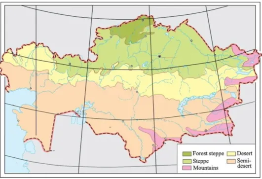
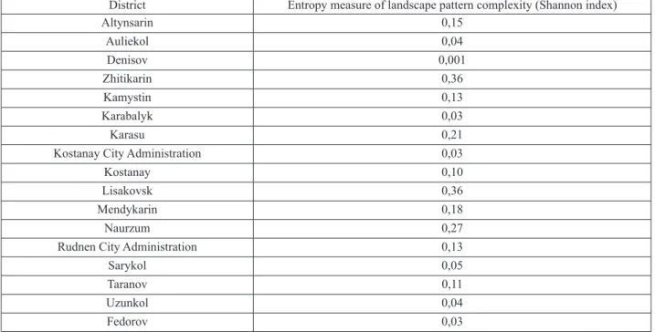
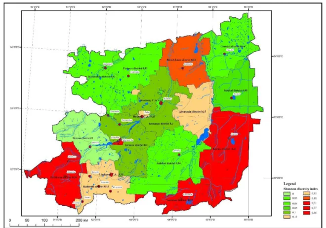
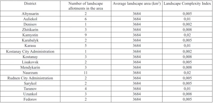
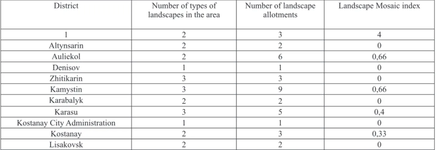
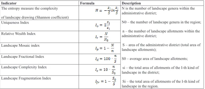
Economic integration of national economic sectors in Kazakhstan's northern border regions with the Russian Federation. A map of the landscape diversity of the territory of the Tobol River basin in the Kostanay region according to the Shannon diversity index has been prepared. To assess the landscape diversity of the territory of the Tobol River basin in Kostanay.
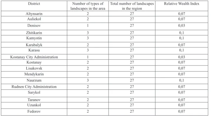
Si – the total area of allocations of the I-th type of landscape in the region. The assessment of the landscape diversity of the territory of the Tobol River basin in the Kostanay region is carried out with the help of a group of tools. Landscape ecological studies for ensuring sustainable development of natural and economic systems of the Republic of Kazakhstan.
Natural and recreational potential of the landscapes of the Tobol River basin within the Kostanay region // GeoJournal of Tourism and Geosites.
КАРТОГРАФИЯ ЖӘНЕ ГЕОИНФОРМАТИКА
CARTOGRAPHY AND GEOINFORMATICS
КАРТОГРАФИЯ И ГЕОИНФОРМАТИКА
Турецкие топонимы в казахстанско-российском приграничье: инвентаризация и систематизация Статья посвящена инвентаризации и классификации топонимов предположительно турецкого происхождения на приграничной территории Российской Федерации с Республикой Казахстан. В результате инвентаризации на приграничной территории Российской Федерации с Республикой Казахстан выявлено 1237 сохранившихся топонимов предположительно турецкого происхождения, в том числе 647 ойконимов, 41 оронимов, 549 гидронимов. В ходе инвентаризации выявлено 1237 сохранившихся топонимов, в том числе 647 кононимов, 41 оронимов, 549 гидронимов тюркского происхождения, образовавшихся в результате длительного пребывания тюрков на исследуемой территории.
Toponyms of Finno-Ugric origin with the finals -l’a, -(e)l’ in the territory of Tambov Oblast // Bulletin of Ugric Studies. Toponyms of the Manchu literary work – Ode to Mukden written by the emperor //Oriental Studies. Mythological context of folk etymology: Hydronyms and oronyms in Khakass non-fairy prose // Sibirskii Filologicheskii Zhurnal.
Электронный ресурс) – URL: https://kaztag.kz/ru/news/deputat-gosdumy-v-efire-pervogo-kanala-territoriya- kazakhstana-eto-podarok-ot-rossii (дата обращения. Депутат Госдумы в е Пожар "Первого канала": Территория Казахстана - е`то подарок от России (Депутат Госдумы в эфире Первого канала: Территория Казахстана - подарок от России. Электронный источник) (КазахТелеграфАгентство) - URL: https://kaztag.kz/ru/news/deputat-gosdumy-v-efire-pervogo-kanala-territoriya-kazakhstana-eto-podarok-ot-rossii (Доступ. Топонимы финно-угорского происхождения с окончанием - л'а,-(е)л'на территории Тамбовской губернии.
Dagiti Toponimo ti Literario nga Obra ti Manchu – ti Oda kenni Mukden Insurat babaen ti Emperador //Oriental a Panagadal, Oktubre 27, 2015 5. Stepeni (PhD) Doktor ti Pilosopia Po Spezial`nosti 6D021200-Turkolohia (Naipakasaritaan ken semantiko a panangipalawag kadagiti toponimo ti Orkhon- Yenisei -monumento: abstrakto Oskorbitelnoe iti neo-objektibo a panagpukaw Tigrana Keosayan (Makainsulto ken mangidumduma a panagsao babaen ni Tigran Keosayan).-neoobjectivenoe-vyistuplenie- tengnga ti Kazakhstan-467452/ (Bisita.
МЕТЕОРОЛОГИЯ ЖӘНЕ ГИДРОЛОГИЯ
METEOROLOGY AND HYDROLOGY
МЕТЕОРОЛОГИЯ И ГИДРОЛОГИЯ
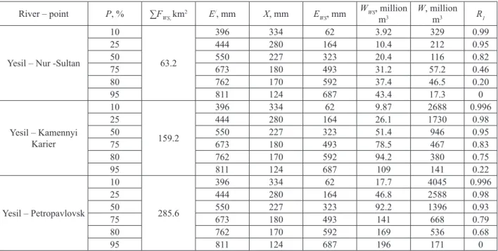
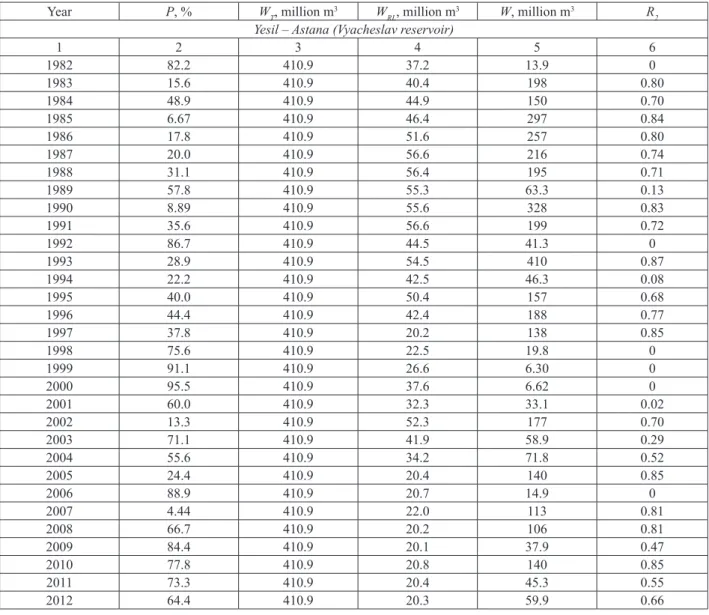
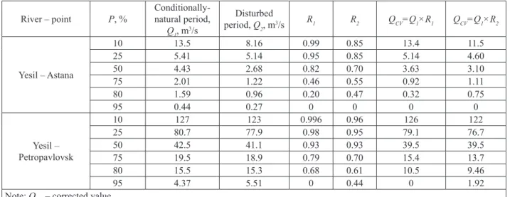
The small useful capacity of the Ishim reservoir transforms the runoff in the lower part of the river very little. The construction of large reservoirs in the studied region led to a gradual change (smoothing) of the intra-annual distribution of the runoff. R=U+W (1) The first component in equation (1) U is a permanent factor throughout the reservoir's existence.
These losses occur in the period from the beginning of filling the reservoirs to the establishment of the underground water regime in the neighboring territories. The influence of reservoirs and ponds on the hydrological regime in the Yesil river basin. The water collected in the spring is used annually for household needs during the rest of the year.
As for the anthropogenic changes in runoff since the late modern period, they are rightly disturbing to humanity. Analysis of the results of assessment of the impact on the runoff of the volumes of filling reservoirs. Floods in the world in the last years of the twentieth century [Navodneniya v mire v poslednie gody` XX veka].
О влиянии плотин на годовое распределение стока рек Ишим и Тобол. К оценке современных и возможных в перспективе антропогенных изменений внутригодового распределения стока Нижней Волги. Оценка современного изменения внутригодового распределения стока крупных рек под влиянием водохранилищ.
ГЕОЭКОЛОГИЯ
GEOECOLOGY
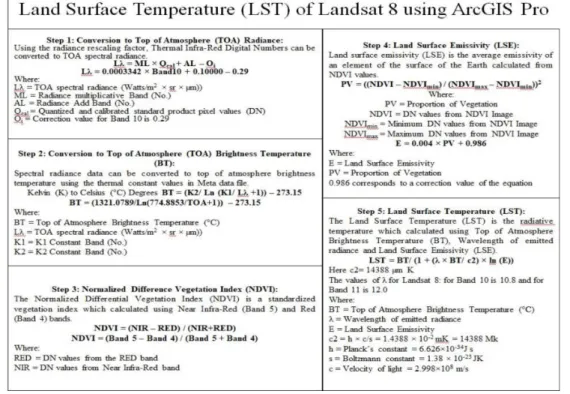
Growing urbanization increases the intensity and frequency of the Urban Heat Island (UHI) effect in highly developed cities. Urban heat island is one of the most studied environmental problems at a local climate scale. One of the thermal islands of the Auezovsky district is also a zone on the territory of the Tastak-1 microdistrict at.
Bostandyk district has an area of 99.4 square kilometers, and the population of the district is 234,145 people. Nauryzbay district has an area of 69.7 square kilometers and borders the territory of the Ile-Alatau National Park. According to the available thermal islands of the Nauryzbay district, it is worth starting from the area located in the Shugyla microdistrict near the district akimat.
The level of development in the territory of the district is 40.72%, which corresponds to a value of 30.86 square kilometers. The population of the district is 284,607 people with a settlement density of 7,225 people per square kilometer. The built-up area of the district is 58%, which is equal to an area of 22.96 square kilometers.
Statistical modeling of spatial patterns of the urban heat island intensity in the urban environment of Augsburg, Germany.» Urban Climate, 2019. ArcUHI: A GIS plug-in for automated modeling of the Urban Heat Island effect through machine learning.» Urban Climate, 2022. Urban Heat Island Modeling of Local Climatic Zones in a City Using Sentinel 3 Imagery: Urban Determining Factors.» City climate, 2021.
Implications of the Urban Heat Island for the selection of optimal renovation strategies: a case study in a Mediterranean climate. Urban climate, 2022. Interconnections of the urban heat island with the spatial and temporal micrometeorological variability in Rome.» Urban climate, 2019.
РЕКРЕАЦИЯЛЫҚ ГЕОГРАФИЯ ЖӘНЕ ТУРИЗМ
RECREATION GEOGRAPHY AND TOURISM
РЕКРЕАЦИОННАЯ ГЕОГРАФИЯ И ТУРИЗМ
The purpose of this article is to popularize the ecological route presented in the work, as well as recommendations for the development of ecological tourism in the Karaganda region based on the example of geosystems of the Karkaraly low mountains. Development and management of the tourism sector: a comparative step-by-step overview of Kazakhstan's experiences during the years of independence, 1991-2020. Ministry of Tourism, Physical Education and Sports of the Karaganda Region, State Institution, Karaganda, Kazakhstan.
Prospects for the development of ecological tourism in specially protected natural areas of the Russian Federation. Formation of a tourist cluster on the territory of the Shchuchinsk-Borovoe resort town. In global practice, the tourist cluster is considered one of the most effective tools to increase the competitiveness of the area. The clustering of the tourist space makes it possible not only to streamline the interaction of all subjects interested in the development of tourism in the area, but also to rationally develop the resources of the area in the context of serving tourists.
Involving them in cluster structure will contribute to their active participation in a unified system to build up the value of the tourism product. However, the process of grouping a tourist area is quite complicated and requires the study of both economic and geographical characteristics of the area. The purpose of this work is to consider the possibilities of forming a tourist cluster on the territory of the Shchuchinsk-Borovoe resort area.
The importance of the study is due to the fact that the tourist potential of the area in question has not yet been fully exploited. It is necessary to develop measures that can significantly increase the attractiveness of the area for tourists. The analysis shows that the territory of the Shchuchinsko-Borovskoe resort area has all the necessary features for the formation of a tourist cluster.
Проблемы и перспективы развития и территориальной организации туризма в Акмолинской области: автореферат диссертации на соискание ученой степени кандидата географических наук / М.А. Существенный анализ понятия «кластер» и особенности кластеров в региональной экономике. К вопросу о содержании понятия «туристский кластер».
ТАБИҒИ ЖӘНЕ АНТРОПОГЕНДІК ЖҮЙЕЛЕР
NATURAL AND ANTHROPOGENIC GEOSYSTEMS
ПРИРОДНЫЕ И АНТРОПОГЕННЫЕ ГЕОСИСТЕМЫ
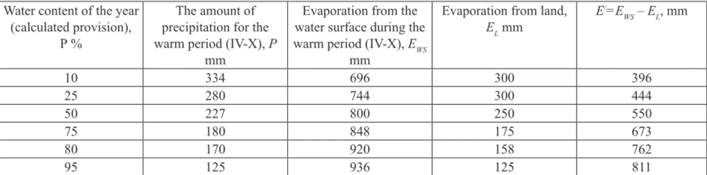
The article discusses the problems of desertification and measures to prevent it, since the desert area occupies most of the territory of Kazakhstan. This is because desertification is directly related to the natural areas of the country. Most precipitation falls in spring, and in summer there is very little rain (mostly dry rain).
In the northern part of the desert there is a brown soil with a humus content of 2.5%, formed on light loam. The desert zone in Kazakhstan covers 2,900 km, from the banks of the Ural River to the Altai Mountains. The main soil of the desert is light brown soil with only 2-3% humus in the surface layer.
The root of the problem of desertification in Kazakhstan can be explained by a review of its geological history. It is the most famous in the world, as well as the largest monument from the Neogene period. In the same year, the government of the Republic of Kazakhstan adopted a national action plan to combat desertification.
It is mainly located in the Alashan region in the western part of the Inner Mongolia Autonomous Region. Desert Problems and Desertification in Central Asia: The Researchers of the Desert Institute: Springer Science & Business Media. Status of desertification and implementation of the United Nations plan of action to combat desertification.