Assessment of glacier area changes in the northern part of the Zhetysu Alatau based on remote sensing data. The study area is represented by the pine forest on the island of Amankaragai, located in the Auliekolsky district of the Kostanay region of Kazakhstan. Keywords: coniferous forest, Amankaragai, remote sensing of the Earth, canopy density, FCD model, Landsat 5 TM, Landsat 8 OLI.
Модель плотности лесного покрова (далее FCD), использованная в нашем исследовании, является новейшим и наиболее важным на сегодняшний день методом дистанционного зондирования. Поскольку ФЦД разделены на 4 класса в каждом интервале, мы получили 16 различных вариантов динамики. По результатам обработки данных дистанционного зондирования Земли с использованием картографической модели FCD по состоянию на 1993 год общая площадь лесной территории составила 33 370,5 га, из них га разреженных лесов и га густых лесов.
Sohrabia, "Forest canopy density estimation using satellite imagery," The International Archives of the Photogrammetry, Remote Sensing and Spatial Information Sciences, Beijing, vol. Henk, "Remote sensed estimation of forest canopy density: A comparison of the performance of four methods," International Journal of Applied Earth Observation and Geoinformation, vol. Das, "Canopy density stratification using biophysical modeling," Journal of the Indian Society of Remote Sensing, pp.
МЕТЕОРОЛОГИЯ ЖӘНЕ ГИДРОЛОГИЯ
METEOROLOGY AND HYDROLOGY
МЕТЕОРОЛОГИЯ И ГИДРОЛОГИЯ
The article presents the results of the work to determine the flow trend of the rivers Zhem, Oiyl and the results of expeditions to the regions of the river's location, carried out in 2021 to assess the ecological state of the basins under the leadership of the working group of scientists Water experts of the Ministry of Ecology, Geology and Natural Resources (MEGCR). The main objective of the work is to assess the flow trends of the Zhem and Oiyl rivers. In order to solve these problems, the dynamics of changes in the main meteorological factors that determine the formation of the river flow in the considered region are taken into account: the sum of precipitation for the winter period, autumn soil moisture, average annual air temperature and anthropogenic influence on the river flow.
Genetic analysis of the assessment of changes in flow since the 1950s revealed a disturbance in flow caused by economic activity with the introduction of a dam system in the river basins for irrigation of estuaries. On the basis of the above studies, the assessment of changes in the flow of the Zhem and Oiyl rivers was carried out by differentiating the average long-term values of the flow in the conditional-natural period with the run-out period with the influence of economic activity and the period of influence of economic activity in connection with changing climatic factors. It was found that during the combined period of economic activity and changes in climatic factors, compared to the conventional period, the flow of the Zhem River decreased by 49%, and the flow of the Oiyl River by 26%.
Keywords: Zhem, Oiyl rivers, changes in river flow, air temperature, precipitation, autumn moistening, economic activity. Climate Change 2014: Mitigation of Climate Change: Contribution of Working Group III to the Fifth Assessment Report of the Intergovernmental Panel on Cambridge Univ. 2014) Sostojanie vodnyh resursov respubliki Kazahstan [The state of water resources in the Republic of Kazakhstan] // Nauka i novye tehnologii [Science and new technologies], No. 2. 2017) INTEGRATED MANAGEMENT OF WATER RESOURCES IN THE REPUBLIC OF KAZAKHSTAN: PROBLEMS AND PROSPECTS //. Journal of Geography and Environmental Management.
IPCC (2014) Climate Change 2014: Climate Change Mitigation: Contribution of Working Group III to the Fifth Assessment Report of the Intergovernmental Panel on Climate Change at the University of Cambridge. Ural Basin (Srednee i nizhnee teche-nie Jemby) (1984) [Long-term data on the surface water regime and land resources. Rivers play a large role in the economy of Kazakhstan - this is the result of the continental climate and the dryness of some areas of Kazakhstan, in which the population's water supply is ensured, as well as the agro-industrial system and infrastructure.
Planning the work of all sectors of the economy requires taking into account the peculiarities of the hydrological regime of the river in each of the seasons of the year. Surface Water Resources of the USSR - Lower Volga River Region and Western Kazakhstan." The result shown is a trend of earlier opening of the river, past ice drift and clearing of the river from ice. All operations and processes on the river can change significantly, due to changes in the thickness and density of the ice cover, as well as the time of its appearance or purification of the river.
Long-term changes in the ice phenology of the Yellow River in recent decades Journal of Climate, 2008 – P.
ГЕОЭКОЛОГИЯ
GEOECOLOGY
Зерттеу нәтижесінде Ұлан өзені алабының карталары мен сызбаларының жинағы (өзен алабының аумағы, топырақ түрлері мен топырақтың механикалық құрамы, өзен арнасының еңісі, өсімдік түрлері мен жерді пайдалану) ArsGIS бағдарламасы және деректерді талдау нәтижесінде бассейннің топырақ эрозиясының көрсеткіштері жылына 0,1-ден 7-ге дейін өзгереді. Ұлан өзені алабындағы топырақтың шайылуын антропогендік геожүйелердің қалыптасу факторларының бірі ретінде бағалау. Топырақты жуу – топырақ ресурстарына және жалпы халық шаруашылығына кері әсер ететін қарқынды және кең таралған геоморфологиялық процестердің бірі.
The use, protection and restoration of the natural environment are the main measures aimed at preventing the leaching of soils from land sources. Currently, the fight against factors causing soil erosion is an urgent problem in the field of agriculture. These problems are directly related to the studied territory of the Ulaan River basin in the East Kazakhstan region.
To determine the degree of soil erosion in the catchment area, the universal formula RUSLE is used. As a result of the research carried out, the ArcGIS program developed map schemes of the Ulaan River basin (the territory of the basin, soil types and mechanical composition of the soil, the slope of the riverbed, plant species and land use), and also determined the indicator of the soil flushing of the basin area, which varies annually from 0.1 to 7.81 t/ha. And further studies and analyzes aimed at changing the indicator of soil flushing will make it possible to identify and study the factors of the formation of anthropogenic geosystems.
ArcGIS программасында үткәрелгән тикшеренүләр нәтиҗәсендә, Улан елгасы бассейнының карта схемасы эшләнде (елга бассейны мәйданы, туфрак төре һәм туфракның механик составы, елга түбәсе, үсемлек төрләре һәм җир куллану), шулай ук 'бассейн өлкәсендә туфрак эрозиясенең билгеле индексы, ул елына 0 - 7,81 т / га тәшкил итә. K факторының RUSLE формуласы буенча бәясе универсаль туфрак югалту тигезләмәсеннән (USLE) (gov.on.ca) таблицалар мәгълүматы ярдәмендә билгеләнде. Мәсәлән, 232 полигондагы А факторының бәясе елына 7,81 т тәшкил итә, чөнки күрсәтелгән төбәк җире таулы булганга, мондый күрсәткеч LS = 10, R = 56,7 факторларының кыйммәтенә бәйле.
Modeling soil erosion in the Chagan River basin of western Kazakhstan using RUSLE and GIS tools//Journal of Environmental Biology. Modeling soil erosion in the Chagan River basin of western Kazakhstan using RUSLE and GIS tools//Journal of Environmental Biology стр.
РЕКРЕАЦИЯЛЫҚ ГЕОГРАФИЯ ЖӘНЕ ТУРИЗМ
RECREATION GEOGRAPHY AND TOURISM
РЕКРЕАЦИОННАЯ ГЕОГРАФИЯ И ТУРИЗМ
- Introduction
- Material and methods
- Results and discussion
- Conclusion
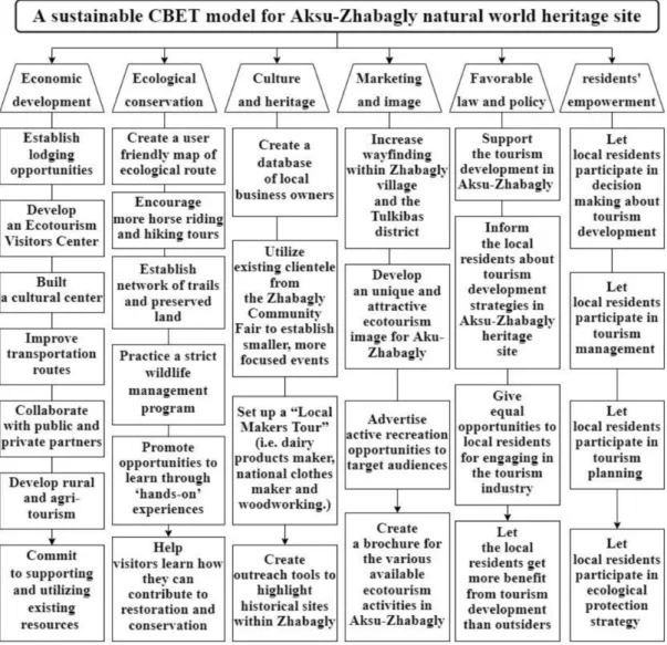
Finally, the article suggests that economic growth, ecological maintenance, cultural heritage, marketing and image promotion, an attractive political environment and population empowerment are essential for the effective implementation of sustainable growth of CNBT on the Aksu-Zhabagly tourist route. Finally, based on the results of the analysis, we will propose the most suitable CNBT pattern for the Aksu-Zhabagly WHS. To gain a deeper insight into the growth of tourism, interviews were conducted with representatives of the Aksu-Zhabagly Nature Reserve and the tourism companies of Aksu-Zhabagly.
One of the main methods of the study was a tabular analysis of documents prepared on the official website of the Aksu-Zhabagly State Nature Reserve (www.Ak-su-Zhabagly.kz). In the mid-1990s, Koh Yao Noi launched a home-based money-making program for 30 to 35 rural residents as part of the CNBT project. The advantages of the above-mentioned best overseas CNBT patterns can be described in the following three main sections.
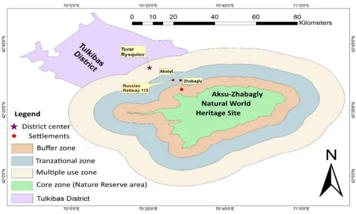
The reserve is one of the best places in the world for bird watching and has great potential for the development of ecotourism. There is also a tourist center with the Western Tien Shan Nature Museum located in the Aksu-Zhabagly WHS administration building. In its half-century history, Aksu-Zhabagly WHS has made a significant contribution to the protection of nature in the republic.
The results of work in this area show that tourism organizers in the region have not done much to develop marketing and image promotion in the tourist area. Based on the results of previous research, we found that the reason for the insufficient active participation of the rural population in the development of tourism in this tourist area is the lack of a favorable political environment for sustainable tourism. Finally, combined with the results of our field investigation, the advantages of the triumphant CNBT patterns abroad, and the advantages and disadvantages of the current tourism growth pattern in the northwestern mountainous area of Aksu-Zabagly, a sustainable tourism pattern for Aksu-Zaba -.
Sustainability of the community-based ecotourism development in the Aksu-Zhabagly nature reserve, Kazakhstan: An evaluation through local residents' perception. REGION, 2022 - no. EVALUATION OF THE COMMUNITY-BASED ECOTOURISM DEVELOPMENT STATUS IN THE AKSU-ZHABAGLY NATURE RESERVE, KAZAKHSTAN.” GeoJournal of Tourism & Geosites, 2021 - no.