1
CHAPTER 1 INTRODUCTION
1.1 PROJECT BACKGROUND
Chan (2013) analysed that people spend 85% of their time indoors and based on that percentage, 20% of their time they spend other indoor places than home. He also stated that, indoor navigation help the user to familiarize with the place. They no longer need to refer to floor directory when walk inside unfamiliar indoor venue.
Nowadays, people like to travel using Global Positioning System (GPS) to navigate where they want to reach. Today’s smartphones are often equipped with GPS receivers that are used to determine a user’s position. GPS signal can determine object or people with accurate position. Inside building, there are GPS signal to be used for navigating inside covered building. When navigating indoor, GPS satellite cannot detect of locate device. So, different technology need to be implemented inside covered buildings to navigate within the building. In that case, stand alone or independent navigation system is required to use for this project. According to Ivanov (2010), one of the popular independent systems is based on dead reckoning (DR). Besides that, today’s smart phones need internet connection to use certain navigation application. This project will be focusing on the indoor navigation application for Kuala Lumpur International Airport 2. Navigating inside big covered airport is not simple or easy task. Airport are busy place which a lots of people walking around inside the building. Navigation app are one of the most important technology when comes to navigating unfamiliar place. Besides that, the development of indoor navigation are expensive as it requires to install high cost device e.g. iBeacon. The use of iBeacon is to track devices and this iBeacon cannot be install at one place, because every angle and rooms need to be install. According to Ozdenizci, Ok, Coskun, and Aydin (2011), low cost and effective navigation system
2
are strongly require inside big covered venue that contain large number of rooms, floors, and departure gate. He add that, user friendly navigation system can be helpful to navigate people inside big covered building which have huge number of rooms. In this project, the author hopes that, this project will give benefit towards passenger at KLIA2 in terms of helping them to search critical or crucial place.
A map may help get user to the airport, but in the meantime, it leaves user at the front door and they don’t know where they should go. There are floor plan or “YOU ARE HERE “directory provided by the company, but people don’t know where here is and they can quickly become lost. This project is to help user to figure out where they are and navigate them from one place to other place using mobile application.
There are many mobile apps that already develop in the market, but it need internet or Wi-Fi connection to use the application. This mobile navigation app will not use any internet or Wi-Fi connection to navigate the user inside the airport of KLIA2.
According to Chan (2013), he stated there are three technologies to ensure the navigation system are effective. The three technology features are accurate positioning, timely tracking, and efficient navigation. Maps are installed on the SD card so there is no need for an Internet connection when navigating. This application also will be equip with addition features like QR code scanner which can help the user to know current position on that place. This application will be useful for all people who visiting KLIA2, especially to those who never been in KLIA2. This project will help user to navigate in KLIA2 and help them to familiarize with the place. This application will display in 3D mode which allow realistic visual map that would help user to navigate easily. In terms of differentiation between this project and other existed project are, this project not required any internet connection and low cost application.
1.2 PROBLEM STATEMENT
One of the problem statements is, hard for the user to navigate through big and newly constructed KLIA2. This problem occurs when, the user want to search for place like toilet, departure gate, shops, and other places. They tend to loss time to search for the place, and might miss their flight. Besides that, for foreigner who needs to wait for interchange flight, they worried if they get lost in the airport if they want to take a
3
walk inside the airport, while waiting to be call for the next flight. This problem also occurred when the user already late for their flight and still searching for the gate for departure. Second, there are no indoor navigation apps that not use internet or Wi-Fi connection to navigate inside the KLIA2. This is because, not all smart phone users that subscribe to data plan, and have high Wi-Fi connection. If the application needs internet connection, the usage of the application is only for those who have internet connection only. This app can be used by everyone either has internet connection or not. Furthermore, many people like to save their money and have free service.
Third is high cost of device installation inside KLIA2. In order to develop indoor navigation for KLIA2, developer needs to purchase high cost device to install all around KLIA2. Besides that, in KLIA2 there are electronic floor directory which the user can navigate. But, the user cannot bring the big screen directory to where ever they go. According to Cave et al. (2013) the cause of navigation difficulties includes length of chosen path and signage. Besides that, passenger can experience confusion or become lost and tend to feel unsatisfied and lead to missed flight. Furthermore, passengers moving around airport, require to make many navigation decisions. Forth is, there are no navigation apps that use Photo Sphere (e.g. Google Street) technology to help user to navigate indoor. The problem occur when the user not recognize or familiar with the place. They tend to get lost or go to other places with wrong path.
This technology helps the user to recognize places before they go to KLIA2. Some of the user doesn’t like to use the navigation apps, but they want to have images of that particular place for them to familiarize.
1.3 OBJECTIVES
I. To study the need for indoor navigation application at KLIA2
II. To investigate the methods can be used throughout the development of this mobile application
III. To evaluate the acceptance of user on the developed mobile application.
IV. To develop a mobile application to assist user in term of finding the shortest path and navigate them to the selected place by using only the features on their mobile phone.
4 1.4 SCOPE OF STUDY
The scope of study for this project is to focus and study the need of this application towards users in KLIA2 who not familiar with the floor plan. Besides that, this project is to study the benefit and challenges in developing this mobile application.
This project also needs to focus on how to develop an application that will be used continuously. In addition, to attract user to use this application, the interface and user friendliness must be interactive and useful because the user is an adult. This will prevent users to get bored and at the same time can be helpful application to navigate them inside KLIA2. Besides that, the QR code will be created and placed at all entrance in side KLIA2 for the user to download and use the app as their assistance to navigate inside KLIA2.
Besides that, to focus on developing a low cost navigation system for KLIA2. Many navigation systems require internet connection and devices to support the system.
But, in this project, the author is focusing to develop a navigation app that not requires internet connection or any high cost devices. This application is stand-alone application and run by itself. This application will be stored in smart phone internal or external memory. The system will help the user to navigate from current location to target location only by using user’s smart phone. Furthermore, this project will focus at level 2 and 3 which is departure and arrival hall. Besides that, these two levels are the most important level as it allocates most of the people who come to KLIA2.
Since it is involve with the user at KLIA2, feedback from them need to be attained to know the acceptance of the application as one of their assistance to navigate inside KLIA2. It is also necessary to seek users view and opinion about the implementation of Photo Sphere in this mobile application as a new approach in indoor navigation system. This is because, the approach is still new and fresh to be accepted by the users. In order to know about user opinion an survey will be conducted at KLIA2. It is also to know and get accurate data about the acceptance and their opinion towards the mobile app. Besides that, the author also needs to conduct an interview with the person in charge of floor plan in case there are any prohibited area that cannot be include inside the application. It is important to know the area that cannot be included in the mobile app as it confidential from KLIA2 side.
5
CHAPTER 2
LITERATURE REVIEW
Indoor navigation app for KLIA2 is one of the ideas to help user to navigate inside the building. KLIA2 is the newest International Airport in Malaysia and the architecture is much bigger than KLIA. People who wanted to travel, they have to locate their departure gate earlier so that, they will not miss their flight. So, there is a need for the navigation system inside KLIA2 to help them reach their departure gate earlier and prepare for enter departure gate. Furthermore, there is no indoor navigation app that has been provided by Malaysian Airport in all over the country.
This app can be a milestone for all big indoor places in Malaysia to implement this technology as their concern to the visitors. Generally this idea has been developed many years ago, but the implementation is only outside Malaysia. Besides that, there are a lot of technology can be used in developing the mobile application as a navigation tool. In this project, we are focusing on the low cost development to reduce cost of infrastructure and installation of any device or hardware. This section will discuss on the literature review for this study which start with the presentation of what are GPS and Navigation System, Understanding Indoor Navigation System followed by the review of Important Indoor Navigation System, Advantage of Using Offline Navigation App, Map Matching Algorithms for Indoor Navigation, and Android as Development Platform.
2.1 WHAT IS GPS AND NAVIGATION SYSTEM?
In this section, the author will explain the basic concept and understanding regarding Global Positioning System (GPS) and navigation system. According to Michael, McNamee and MG Michael (2006) recommended GPS are used to track and monitor
6
human for location based services and GPS also has ability to calculate time, position, and velocity. Triangulation is one of the method to find location or position in GPS. The location can be located if the distance of the object are in range of the three other location are known. Furthermore, according to Spek and Langelaar (2011), GPS tracking also has extra features which it can provide accurate and valid information of quantitative spatiotemporal data. Spatiotemporal data deals with the geometry changing over time and also with the moving object in the location range (Wikipedia, 2015). He also stated that, GPS is built for knowing where people are and navigation is to know where people going. LBS are one of the important features of GPS. Besides that, Diggelen and Abraham (2001) stated that, device need to require satellite signal to track or locate position. In order to do that, the device must search all over possible frequency and code-delay bins. Below figure is the illustration the path for obtains frequency to find accurate position.
FIGURE 2.1: Path for obtains frequency
Besides that, they also stated that there are 28 satellites in GPS constellation. To find the most effective way is by using world network GPS reference station that feed data to server. Next, to obtain accurate and effective navigation using GPS, the device need at least four satellites in view at the same time. Using GPS satellite to track outdoor and indoor is the most preferred as it would not require hardware to change GPS receiver. (Abbott, Verdes, & Calif, 1997)
7
GPS tracking is only for locate where the object or people are, but the main important thing is to navigate users from one place to other place. There is another situation which navigation is not in use, for example, locating missing object like car.
According to Lee (2008), navigation system is useful because it display direction and guidance using graphic, text, and voice information. Smart phone is one of the devices to use portable navigation system. Users can navigate efficiently when using portable navigation system compared to floor plan directory, in terms of time consuming and direction findings. Navigation system is used to show exactly and guidance information to user when two intersections come in place. Navigation system will search for route to the destination from the present location. The route will be display to user’s side to navigate the route and will follow the direction that present by the system. Navigation system also can detect present position and during navigating position are displayed to show the correct route. (Nimura et al, 1993) In another aspect, navigation system has its own database to store node message with node image information. This node image is about geographical features of node and data for storing maps information. (Park, 2004)
2.2 UNDERSTANDING INDOOR NAVIGATION SYSTEM
It is important to understand the working mechanism of Indoor Navigation as this innovation have been attempted to operate based on Indoor Navigation system.
According to Montañés, Rodríguez, and Prieto (2013), indoor positioning is a system that provides correct location inside covered building. He also stated that, in large building or covered area, this system is able to track people and object. In term of indoor navigation system, Chandgadkar (2013) stated that Global Positioning System (GPS) is used for navigate outdoor environment and because of weak signal inside the building, navigating indoor is difficult. This statement also has been point out by Jo´ A´ gila Bitsch Link, et al (2011) they mention that, navigation inside covered building still difficult to develop. One of the reasons is, hard to get correct location in a low installation cost and to design indoor maps.
According to Bittins (2012), the level of difficulties in networking system in indoor environment is lower than outdoor environment, because it has lesser features, for example weather condition and traffic situation. In addition to that, many researchers
8
have come out with their solution to develop an indoor navigation system. According to Montañés, Rodríguez, and Prieto (2013), the technology that can be used to locate cellular network is Local Area Networks (WLANs), Bluetooth, Ultra- wideband (UWB), Ultrasound, Radio Frequency Identification (RFID), Hybrid technologies, and QR scanning method. These are the explanation of the techniques can be used in indoor navigation system.
2.3 IMPORTANT AIRPORT INDOOR NAVIGATION SYSTEM
KLIA2 indoor navigation app is really important because KLIA2 is a huge building with many shops and routes. Besides that, searching for departure gate is difficult when the passenger is not familiar with the place. Caves and Pickard (2001) stated that one of the concern passenger feels is finding way to departure gate. Navigating through huge building and a lot of shop may lead to confusion. We might lose in our way to get to the departure gate because of many route and ways to get there. Besides that, there are many elevators which can be access, but not all escalators can bring us to the same level. For example, elevator No.1 only can bring us until 2nd level, but elevator No.2 can bring us until 3rd level. He also mentions that, high quality navigation system would help to reduce time for movement inside airport and avoid from getting loss during navigating. By reducing time or movement, the user can reach their destination quickly and have more time to rest before departure.
According to Horonjeff (2010), passengers who have difficulty finding departure gate will have stressful experience and they might missed their flight. When time is short, passengers need to arrive to the gate early. When missed flight, they not only waste their money, but also time. The function of this app is to help user to avoid from missing flight and be ready at the departure gate earlier then departure time. Tam, and Lam (2004) also stated that, despite the availability of floor directory, some people still struggling in locating their destination. Not many people want to look for floor directory because they don’t want to waste time for that. Besides that, many floor directory are placed in every level are not being used by the people when locating their destination. Based on the research, indoor navigation app for KLIA2 is really important for people because many difficulties found in people side for them to locate their destinations.
9
2.4 ADVANTAGE OF USING OFFLINE NAVIGATION APPLICATION Many navigation app need GPS or other network connection in order to navigate user from one point to another point. In term of indoor navigation, different technology needs to be used because GPS signal cannot be received in covered building such as KLIA2. So, in that case, this project is attempting to develop indoor navigation app without any network connection. This idea is to lowering the installation cost of any high technology devices. According to Togneri, and Deriaz (2013), there is several mobile applications that allow user to download maps for offline use. But, it still needs internet connection to calculate routes and navigate. Besides that, it would be an issue when travelling abroad due to data roaming. He also stated that, offline navigation would solve the service unavailability because of weak internet connection and allow indoor navigation.
Besides that, offline navigation app is stored in smartphone memory. The app will run in high performance because the all the file and program is inside the smartphone itself. Offline navigation really helps the user to navigate inside KLIA2 because it not required or depends on any network connection. According to Park (2004), offline navigation service can performed same as online navigation service. The system may be same in term of pointing the current position of the user and navigate to another location. The system not only can navigate user, but also provide information and can performed as fast as online navigation system. The offline navigation might require current position of the user, but online navigation system will automatically locate the user position.
According to Barker (2014) the benefit of using offline navigation app is cutting down on data roaming while travelling. Most navigation apps required internet connection to have all the maps details. Using foreign networks to download and roaming can be extremely expensive. He also stated that, offline navigation app can perform fasted loading times. This is because, the information or maps are stored on users smart phone. There will be no buffering time when using offline apps. Besides that, offline app are faster in zooming and panning, because the apps is already installed in users phone and no waiting time when the user want to zoom the maps.
The users’ phone would have better battery life as the apps not using any internet connection. Other than that, there would be no issues when Wi-Fi connection are
10
slow or not available as the apps can operate without any internet connection and users still be able to navigate.
2.5 MAP MATCHING ALGORITHMS FOR INDOOR NAVIGATION
Maps used outdoor are different from indoor maps, because the route and path are different as outdoor has more straight road and intersection. But indoor maps have many rooms and small section to locate. According to Wilk and Karciarz (2014) indoor navigation is for pedestrian who walk in slow speed. Indoor navigation application requires navigation direction for them to navigate inside covered buildings. In terms of indoor navigation, the directions are different from outdoor navigation. Indoor maps routes cannot be used inside building as areas are limited to doors and rooms. Building Information Model (BIM) or Geographic Information System (GIS) are the solution in indoor mapping. There are several Map Matching algorithms,
Geometric
This approach uses geometric information of the road network. This approach is possible by checking the position of node and also network links. The most effective solution is known as point-to-point matching. For example, link with dense node are more accurate and assigned correctly. Curve to curve method matches users trajectory against path network. (Quddus, Ochieng, & Noland, 2007)
Topological
Another method called topological are been used for geometric algorithim which consider relationship between lines, points, and polygons. According to Shin, Park, and Choi (2010) he proposed topological MM algorithm with virtual path. This approach should present based on input from dead reckoning (DR) algorithm. There are two step involve in this algorithm, first is determines candidates links by calculate distance between current location and link. Second step is, compare heading of estimated azimuth of pedestrian and heading of the link. to identify final link, the link with smallest heading difference should be occur.
11 Advance
According to Davidson, Collin, and Takala (2010) stated that, this method is known as particles filtering make usage of building floor plans. This method required information about obstacles. It uses random samples to present posterior density of the user’s location in dynamic state estimation.
2.6 ANDROID AS DEVELOPMENT PLATFORM
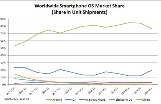
The objective for this section is to compare Android and IOS operating system. The author used android operating system as platform to develop this project. According to Denis Huber (2011) smart phone nowadays can use three different methods to locate their position, which are Satellite Positioning, Wi-Fi Positioning and Cellular Positioning. To support the idea that the system should be developing using Android platform, the author has come out with several evidence. There are three areas that should be identify, which is the number of Android smartphone users, downloaded apps, and market share. In terms of number of Android smartphone users, in article titled “Android still the dominant mobile OS with 1 billion active users” stated that Google has I billion active users on the Android operating system. Besides that, number of users who check their smartphone are 100 billion times every 24 hours.
This is to show that, the number of user in Android devices is keeping on increasing.
This would be a good chance to develop using Android platform. In addition, Apple’s users are fewer than Android users which are 800 million of users.
TABLE 2.1: Smart phone market share Period Android iOS Windows
Phone
BlackBerry OS
Others
Q4 2014 76.6% 19.7% 2.8% 0.4% 0.5%
Q4 2013 78.2% 17.5% 3.0% 0.6% 0.8%
Q4 2012 70.4% 20.9% 2.6% 3.2% 2.9%
Q4 2011 52.8% 23.0% 1.5% 8.1% 14.6%
12
FIGURE 2.2: Smart phone market share
Furthermore, the number of downloaded apps between Android and IOS need to be identified. According to Canalys (2013), in article titled “Who’s Winning, iOS or Android? All the Numbers, All in One Place”, he stated that in 2013 half of all downloaded apps are come from Android users. 51% are for Android and 40% are from Apple or IOS users. The downloaded app is more on Android devices because there are more users using Android and also many free apps are available in Play Store. This statistics is important for this project because this project is low cost or free mobile application for all users. In terms of market share, in article called Smartphone OS Market Share, stated that, Android dominates market at 76.6% share in 4Q14 and Apple at 19.7% share. Apple managed to ship 74.5 million units with year-over-year growth of 46.0%. Many investors spend their money to invest for Android. Android smartphone is one of the best smartphone in year 2013, and this is the reason why Android so successful. The market share is really important for development of the device, because every new project need funds and money to keep on developing good smartphone. This is the three main reasons why the project will be developing using Android platform.
13
2.7 PREVIOUS WORK BY FORMER RESEARCHERS AND REFLECTION Jo´ A´ gila Bitsch Link, et al (2011) stated that, for navigation purposes, they integrate their system with OpenStreetMap which already can support indoor development. They are not using Pseudolites, UWB, WiFi access points and RFID for their project. This is because they don’t want their system to interfere medical equipment with their additional RF gear. For generating maps, they using OpenStreetMap to create and distribute free geographical data. OpenStreetMap allow other people to edit map data easily. This statement different from the author project, as the KLIA2 floor maps will be in 3D maps and not use OpenStreetMap. For this researcher project, they are using step detection which use the functionality of accelerometer and a compass. In KLIA2 Indoor Navigation app, the author uses current and to location features. This means, there are no compass or acidometer involve in the application. The system will display the correct path by using arrow as guidance.
Another project is location based service using vision navigation method. According to Huang and Gao (2011) the navigation technology can use iPhone camera to navigate. But it requires Wi-Fi connection to use the device. The goal of this project is to match user’s single shot of hallway with a floor database, and allow the user to receive accurate position. The photo captured by iPhone camera and detection algorithm is applied to extract photo and show correspondence floor plan. For KLIA2 navigation app, floor plan already stored in the application itself. If the user wants to refer floor plan, the user can select on the maps option to view. It is different from the researches project which using camera as guidance for navigating indoor.
Previous studies have reported existing indoor navigation system has many problems and to solve this problem, the researcher has come out with the new technology called Near Field Communication (NFC). This technology can be used by touching tags which located all around the building. This project requires user to touch URL Tag to get address regarding maps floor. The information regarding maps is stored in MapServer. The application will asks users to enter location to start navigate. The application will show the shortest way to reach to user’s destination. (Ozdenizci, Ok, Coskun, and Aydin, 2011). This researcher has come out with the tag scan for indoor
14
navigation system. this system are different from author project which used smart phone to locate or navigate inside covered building. Other than that, the similarity can be identify by calculating shortest path. This algorithm to find shortest path can be used in KLIA indoor navigation application.
15
CHAPTER 3 METHODOLOGY
3.1 RESEARCH METHODOLOGY
FIGURE 3.1: Research methodology phase
•Analyse the problem
•Identify the people involved
•Passenger hard to find certain places e.g.
departure gate and ticketing booth.
•Analyse the objectives Phase1
Background of study
•Quantitative techniques
•Survey and observation method
•KLIA2 as survey location
•Discuss and idetify feedbacks in results&discussion
Method Pleminary studies
•Understand what is GPS and Navigation System
•Advantage of using offline navigation app
•Map matching algorithms for indoor navigation
•Review about other researcher about communication device
Literature review
•Rapid Application Development (RAD)
•Requirement/ Planning, System Design, Development, & Cutover
•tools for fevelopment Phase 2
Development
•Activity Diagram
•Use Case Diagram
•Class Diagram
•System Architecture
•Prototype (User Interface) Deliverable
•The prototype is tested to determine the user acceptance.
•Determine it's feasibility and usability Testing
16 PHASE 1: BACKGROUND OF STUDY
For phase one, the author focus in identification of problems and techniques to collect project requirements. To gather information regarding this project, the author has done several researches on research paper, article, and journal to get many information as possible. The method that author use in phase one are qualitative techniques, which is survey and observation. The author conducted survey at KLIA2 to obtain accurate data from users and also spend five hours to observe situation at KLIA2. Besides that, writing literature review is one of the method in phase one.
Based on the method, the author has come out with collection of data from the survey, tools for development, Gantt chart, and key mile stone.
PHASE 2: DEVELOPMENT
For phase 2, the author focuses on the development of mobile application prototype.
The author chooses Rapid Application Development (RAD) as development method to develop mobile application in short time period. Based on the method, the author has come out with several diagrams which are activity diagram, use case diagram, class diagram, and system architecture. Besides that, the application needs to be test from both side which is developer and the users. Lastly, the author use software tool to design user interface prototype for this project.
3.1.1 SURVEY/QUESTIONNAIRE
For information gathering on the KLIA2 indoor navigation app, the author target group is passengers and visitors at KLIA2. The intention of the survey is to identify the important of indoor navigation app and the problem faced by the targeted group.
Author has been to KLIA2 to conduct the survey because the respondent can answer the survey based on the environment surrounding them and the results are more accurate. For the survey 50 respondents were responding to this survey on 14th March 2015. The reason why author choose the date is because, on Saturday there are more visitors at KLIA2 and more easy to get good feedback. Therefore, conducting survey is easier because of many people in KLIA2. From 50 respondents, 23 of them are male and other 27 respondents are female. Based on the statistics, the result will be discuss on the next chapter.
17
The survey consists of 14 questions and aims to identify the acceptance of KLIA2 indoor navigation app based on respondent behaviour and attitude towards questions given. Besides that, this survey is to identify the type of display that they preferred when navigating inside KLIA2. Some of the respondent extremely confident that finding departure gate are difficult and hope this navigation app could be the solution when they want to search for point of interest (POI). Detailed explanation regarding the survey result will be further discussed on the next chapter. Page 1 is about respondent demographic. Four questions were asked to capture the information on students’ details such as their gender, age, race and education background. These questions were asked for developer to identify respondent details. Besides that, two more questions is to identify the type of phone they use and how frequent they come to KLIA2. Page 2 consist of eight questions is to get details on students’ knowledge about mobile technology, in particularly the questions asked how deep their knowledge about mobile technology is. Besides that, these questions also to identify the problem and also user acceptance for this mobile application. Other than that, to know respondent feedback about the indoor navigation app and can this application solve the problems and also preferred display of maps.
3.2 DEVELOPMENT METHODOLOGY
In this chapter of Methodology and Project Work will cover in depth methodology used to complete this project. To ensure all the findings and methodology practices align with author project goal, input from these field are mainly generated from establish journal and articles for others to take advantages to improve for further studies. For the evaluation benchmark for this project, methodologies used are based on Rapid Application Development. In order to develop KLIA2 Indoor Navigation Application, several research of project methodology have been carried out in order to select the suitable methodology for this project and allow the author to come out with the overall planning in the development lifecycle.
Rapid Application Development or commonly known as RAD has be selected as development methodology for this project. One of the reasons for choosing this methodology is time constraint because the author was require to complete the project in 6 months. For that reason, RAD process is chosen to emphasize on short development cycle as well as producing high quality product. In general, RAD
18
approaches will be able to focus more on the development and less focus on planning task. In addition, RAD process emphasize on the rapid prototyping as well as application development. This type of development is really efficient when the developer has more time to complete the application. There are four main areas include in the RAD lifecycle: Requirement Planning, System Design, development, and Cutover.
FIGURE 3.2: RAD lifecycle
Requirement/ Planning
As mentioned before, during requirement planning, the author has conducted several researches regarding issue that related to the KLIA2 indoor navigation app.
Preliminary survey was conducted to gain early stages of data requirements and obtain the users feedback regarding the project. The survey has been conducted at KLIA2 to gain most accurate feedback from the users. This phase is important because every project needs know users’ requirement before the development stages can start. Besides that, set up a storyboard and sketch the interface of the application which provides an image how the application should be like to stakeholders.
System Design
Design of a system can be seen as the application research theory application development. In this phase, the users can see working prototype and also understand the process flow of the program. In simple word, it describes how the application
19
will function in the future. Therefore, the author have come out with several design, including the system architecture, use case diagram, class diagram, and graphical user interfaces (GUI) of the application. Besides that, this phase will determine which system can be used to develop the application.
Development
In this phase, the author will begin to develop the prototype of KLIA2 indoor navigation app. Prototyping is not fully develop application, it can be seen as incomplete version of the application that are being developed. In this phase, the author determines the tools that can be used for building user interface and create function inside the application itself. After finishing the first prototype, the developer can present it to project supervisor for testing. The purpose of this phase is to get valuable feedback from the user and project supervisor for further improvement.
Besides that, it is really important to come out with well develop prototype to meet user expectations as well as project objectives.
Cutover
This is the final phase of RAD process. During this phase, there are several activities are being performed including data conversion, testing and user training. In data conversion, the application will be install in users smart phone for testing purpose. In testing phase, the user an developer will test the application based on their criteria.
For user, the test the application whether it can be accepted and what are the error that need o be consider. For developer, they need to test part by part and this test called integration testing. Besides testing, the developer needs to train users how to use the application. Lastly, the author require to submit the finalize report to FYP supervisor and coordinator as well as presenting the real application system to the examiners.
20 3.3 GANTT CHART (FYP 1)
Deliverable Name/Task Name Week
1 2 3 4 5 6 7 8 9 10 11 12 13 14
1. Planning Phase
-Preliminary Research Work -Identify Problem statement -Define Objectives
-Define Scope Of Study
-Literature review on subject matters 2. Analysis Phase
-Data collection -Prepare questionnaire -Distribute questionnaires 2. Analysis Phase
Analysis of Project
-Determine function/non-functional of system -Verify changes and prioritize requirement -Determine tools for development & designing Last preparation of
report
Submission of Interim Report Proposal Defence
TABLE 3.1: Gantt chart for FYP 1
21 3.3 GANTT CHART (FYP 2)
Deliverable Name/Task Name Week
1 2 3 4 5 6 7 8 9 10 11 12 13 14
1. Designing Phase Layout Design
-Design system architecture -Determining tools requires 2. Designing Phase
Programming
-Designing project interface 3. Designing Phase -System coding
-Design and create database 4. Testing Phase
-Project testing
-Analyse testing result -Application testing by user -Debugging major problem -Debugging minor problem -Implementation testing for user 5. Deliverable Phase
-Review application Documentation VIVA
TABLE 3.2: Gantt chart for FYP 2
22 3.4 PROJECT MILESTONE
No. Deliverables/Activities Schedule
1 Proposed Project and Project Proposal Submission Week 2 – 3
2 Proposal Approval Week 4
3 Literature Review Week 5 – 7
4 Data Requirement (Questionnaires) Week 8
5 Process and System Modelling Week 9
6 Develop User Interface Week 10
7 Submission of Interim Report Week 11
8 Proposal Defence Week 13
9 Development of Module Application Coding Week 15 – 21
10 Development Completed Week 22
11 Testing (User Acceptance Test) Week 22 – 25
12 Viva Week 26 – 27
13 Project Submission Week 28
TABLE 3.3: Project Milestone
3.5 TOOLS REQUIRED
In order to develop Indoor Navigation App, the author has identified hard ware and software that need to be use.
3.5.1 HARDWARE
I. Personal Computer (PC) a. Window 7
b. 4GB RAM
c. 400 MB hard disk space
d. 1280 x 800 minimum screen resolution e. Java Development Kit (JDK)
II. Android Devices (smartphones or tablets)
a. Operating system: Android OS, v4.1.2 (Jelly Bean) or above b. CPU: Dual-core 1.2 GHz Cortex-A9
c. Memory: 8GB (Internal), 1GB RAM
23 3.5.2 SOFTWARE
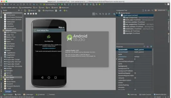
Eclipse ADT (Android Development Tools)
FIGURE 3.3: Android Studio interface
According to Wikipedia, Eclipse IDE use Android Development Tools (ADT) as additional content to provide integrated environment, which can built Android application. Besides that, ADT allows Eclipse IDE to create new Android projects, application UI, and debug their application using Android SDK. Other than that, Eclipse IDE is a tool for developing application in android smartphone. It has more function and capabilities compare to App Inventor.
The Eclipse IDE provides the standard source-code editing tools, along with a source-level debugger that allows applications to be debugged on both the simulator and a physical device. This software is an addition function to add on in to mobile app which App Inventor cannot perform.
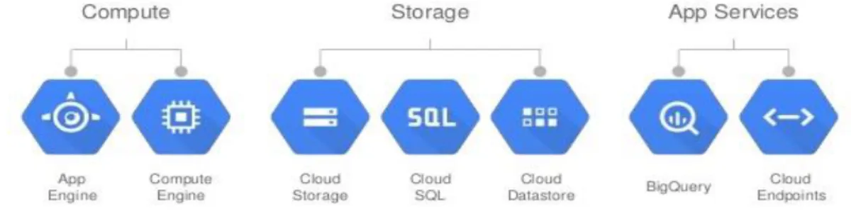
24 Google Cloud Platform
FIGURE 3.4: Google Cloud Architecture
Google Cloud Platform is a web server where it uses cloud computing to store, distribute, replicate and load balancing of data behind simple application programming interface (API). In order to store data in the application, the component in App Inventor called Tinywebdb need to link with Google cloud platform that uses python in storing the data in database.
25 CHAPTER 4
RESULT AND DISCUSSION
This chapter focus on the information collected from survey to be further analysed and discussed. For information gathering author mainly use survey as author main method to obtain input from visitors at KLIA2. At the end of this chapter, author will also further explain the benefits of navigating inside KLIA2 and how this application could help users to find difficult location inside KLIA2. Besides conducting survey as preliminary study, the author also use observation method to gather information regarding this project.
4.1 OBSERVATION
Through observation at KLIA2, it gives the author idea on how the future project needs to work. During author observation at KLIA2, two people were asked where the departure gate is. This shows that, navigation application really need to be develop to solve the situation. This fact finding technique is the more first hand and objective measures of needs and the problems that passenger facing on. Observation is one of the easier fact finding method because it is not expensive and save outlay.
4.2 RESULTS OF DATA GATHERING
Derivation of survey results collected by author will undergo critical analysis for interrelated data among relevant input to be done in order to produce meaningful information supporting author project main objectives.
26
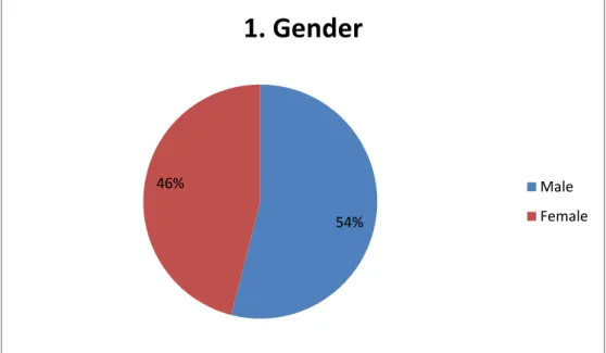
The authors prepared a set of relevant question ranging from demographics of the respondents. There are 14 questions prepared by author which being distributed at KLIA2 to get some responses and opinions from the users. 50 respondents have responded to the survey and majority 54% or 27 of them are male while the other 46% or 23 are female students.
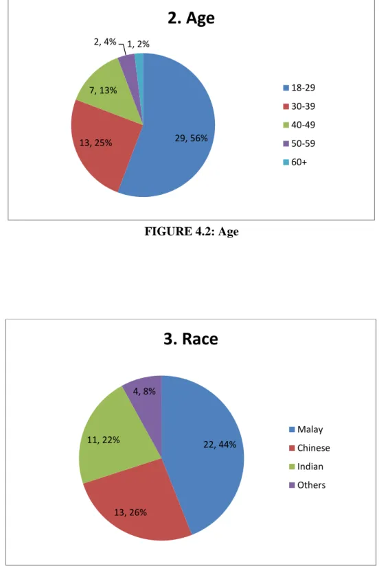
The respondent age distributions are mainly ranging 56% respondent between ages 18 to 29 years old, 25% between age 30 to 39, 13% between age 40 to 49, 4%
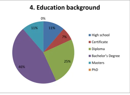
between age 50 to 59 and the rest 2% are from respondent with more than 60 years old. The survey also did gather information on the race for each respondent.
50 respondents have responded to the survey and majority 44% or 22 of them are Malay, 26% or 13 of them are Chinese, 22% or 11 of them are Indian, and the rest come from Others which is 8% or 4 of them.
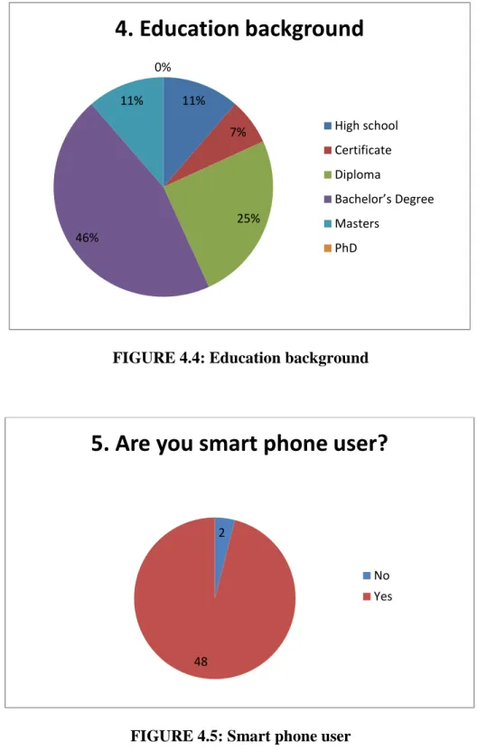
For the next survey, the author is focusing on education background to determine level knowledge of each respondent. Basically, there are five main qualifications which is High school, Certificate, Degree, Masters and PhD. Basically, Degree holders among parents shows the highest amount that is 46% meanwhile Masters and High school shows the lowest amount by 11% for both of categories.
FIGURE 4.1: Gender
54%
46%
1. Gender
Male Female
27
FIGURE 4.2: Age
FIGURE 4.3: Race
29, 56%
13, 25%
7, 13%
2, 4% 1, 2%
2. Age
18-29 30-39 40-49 50-59 60+
22, 44%
13, 26%
11, 22%
4, 8%
3. Race
Malay Chinese Indian Others
28
FIGURE 4.4: Education background
FIGURE 4.5: Smart phone user
The pie chart above illustrates the number of smart phone user at KLIA2. There are 48 of the respondent are using smart phone as communication device and 2 of the respondent are not using smart phone. It is necessary for the user to have smart phone as the application will be installed in Android platform. In this case, the majority of the respondent are using smart phone, so it is applicable for the author to develop this application as the target user are huge.
11%
7%
25%
46%
11%
0%
4. Education background
High school Certificate Diploma
Bachelor’s Degree Masters
PhD
2
48
5. Are you smart phone user?
No Yes
29
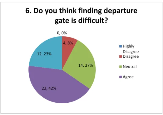
FIGURE 4.6: Departure gate difficulties
This is the most important question which to identify the needs and problem when navigating inside KLIA2. The result shows that 42% or 22 of respondent agree that, finding departure gate is difficult. The rest are, 23% or 12 highly agree, 27% or 17 neutral, and 8% or 4 disagree. Majority of respondent agree that, finding departure gate are difficult, this is because they are not familiarize with floor plan in KLIA2.
Besides that, they rarely come to KLIA2 to travel and most of the respondents use KLIA2 for travel at least 1-2 times a year and 3-4 times a year. This reflect back the result of survey that how often respondent use KLIA2 to travel. In addition, KLIA2 is much bigger than KLIA or other Malaysian Airport, so it’s not easy for us to know each place and path inside KLIA2. Besides focusing on departure gate, the author also mentions about curtail places like toilet, lost and found counter, ticketing booth, and more. Based on the result, we can analyse that this mobile application need to be develop to help solve users difficulties in finding departure gate and also other places.
0, 0%
4, 8%
14, 27%
22, 42%
12, 23%
6. Do you think finding departure gate is difficult?
Highly Disagree Disagree Neutral Agree
30
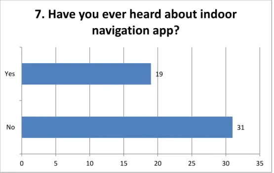
FIGURE 4.7: User knowledge about indoor navigation
The next question that been ask to the respondents is “Have you ever heard about indoor navigation app?” This type of question is to study whether Indoor Navigation App is well known among KLIA2 visitors. The result shows that, 19 respondents know and heard about indoor navigation app, meanwhile 31 of them never heard about indoor navigation app. This result shows that, indoor navigation app is quite new for majority of the respondent. This also an opportunity to introduce to them the new technology that would help solves their problem in term of finding location inside covered building.
31 19
0 5 10 15 20 25 30 35
No Yes
7. Have you ever heard about indoor
navigation app?
31
FIGURE 4.8: Indoor navigation useful
Most of the respondents agree that indoor navigation is useful for big building. Based on the result, we can see that, indoor navigation app, is not only acceptable for KLIA2, but also other building. Besides that, there are also respondents which disagree with the statement, this is because, they like to walk without any assistant from navigation app and they might familiar with new venue quickly. The result shows, over 50 respondents, 44% or 22 are agree, 26% or 13 are neutral, 22% or 11 are highly agree, 8% or 4 are disagree and no respondent highly dis agree with the question.
0, 0%
4, 8%
13, 26%
22, 44%
11, 22%
8. Do you think this indoor navigation app is useful for all big indoor places like airport,
hospital, and shopping mall?
Highly Disagree Disagree Neutral Agree Highly Agree
32
FIGURE 4.9: Develop indoor navigation
This survey is about KLIA2 and indoor navigation app. The question is “Do you think KLIA2 should develop indoor navigation app for the visitors?” Based on the result, we can identify that, 47 respondents think KLIA2 should provide their own navigation app for all their visitors and passengers. Meanwhile, 4 respondents think KLIA should develop navigation app. The reason is, some of the respondents are already familiar with the floor plan inside KLIA2.
FIGURE 4.10: Indoor navigation is helpful
4
46
9. Do you think KLIA2 should develop indoor navigation app for the visitors?
No Yes
0, 0% 0, 0%
4, 8%
36, 72%
10, 20%
10. If indoor navigation in KLIA2 is already been implemented, do you
think this app is helpful.
Highly Disagree Disagree Neutral Agree Highly Agree
33
This question is to identify the usefulness of Indoor Navigation Application for KLIA2. Respondents have been asked several questions to understand the technology and objective of this project. This question is to show that, this app is helpful for all users. Majority of respondent agree that, if this application has been developed, it may help them to navigate inside KLIA2. Besides that, 20% or 20 respondents highly agree because they might face many problems when walking inside KLIA2 to search interest place. Surprisingly, there are no respondents choose highly disagree or disagree because, sometimes experience travellers also facing the same problem.
FIGURE 4.11: Method to develop
This question is to identify the acceptance of method for developing of this application. This application would not use any internet connection because internet connection will be limited at certain areas and places. Based on the result the, majority respondent agree that, this mobile application should run by its own.
Besides that, 27% or13 respondents highly agree, 18% or 9 are neutral and 12% or 6 disagree among 50 respondents. Not all users have data roaming to user any online application and besides that, offline application can be used by all users without
0, 0%
6, 12%
9, 18%
21, 43%
13, 27%
11. Do you agree that, indoor navigation app should use stand-alone (not required any internet connection)
approach to minimize cost of installation and development?
Highly Disagree Disagree Neutral Agree Highly Agree
34
worrying the internet connection. Furthermore, this question really supported by agrees and highly agree answers. So, offline navigation app is the most preferred and cost effective.
FIGURE 4.12: Navigation display
In this question, the author wanted to identify which navigation display respondent preferred. These preferred navigation displays consist of three, which is 2D maps, 3D maps, and Sphere Photo. Based on the survey, we can identify that; majority of respondent would prefer 3D maps as their navigation display. This is because;
respondent might be used outdoor navigation system, and they already familiar with that display. Besides that, they might think that, 3D maps more easy to view and navigation compared to 2D maps and Sphere Photo. In addition, there are 14 respondents choose 2D maps, and 6 choose Sphere Photo. The technology of Google Street is still new to some people that might be the reason why Sphere Photo is less preferred.
14
30 6
12. What type of navigation display do you prefer?
2D maps 3D maps Sphere Photo
35
FIGURE 4.13: Application download
The last question that been ask to the respondents is “If this app already in market, would you download it?” This question is to identify the future of this application whether this application would be install by the user. Surprisingly, majority of respondent would like to download the application as their guidance when navigating inside KLIA2. Out of 50 respondents, 46 of them would install the application. The remaining two respondents that would not download this application, they might already familiarize with the location and environment inside KLIA2. So, this result approve that, people willing to download this application to make sure they are on the right direction and location.
4
46
13. If this app already in market, would you download it?
No Yes
36 4.3 USE CASE DIAGRAM
FIGURE 4.14: Use case diagram for indoor navigation
There are two actors engage in this system, there are user and system administrator.
For the actor user, there are two use cases involve. First use case is for the user to choose option which determines the selection of view. Second use case is view maps.
In view maps, the user need to select level or floor to view the maps, this use case is include under view maps. Third use case is view directory. In this use case, the user can view directory and select category for example like service, money changer, gifts, and many more. The select category use case is included under view directory.
Last use case involve in actor user is navigate. This navigate use case is for the user to navigate maps or directory. Besides that, there are include use case for navigate function, which the user can directly navigate by selecting level and position. But in this prototype, the level and current position is only available at floor 3 and the doors. The reason is to test whether this application can really be built for future development. Then, the users can select destination by select categories and destination. The next actor is system administrator; the role of this actor is to manage system. The function that involve in manage system are update, delete, create and improve system.
37 4.4 SYSTEM FLOW CHART
FIGURE 4.15: Flow chart diagram
38
Figure 4.14 show the activity diagram for Indoor Navigation App for KLIA2. The first step that need the users do is to open the application. Then, the user will proceed to the main page of the application. The user will select option between maps and directory. The system will display the level and category under each of the options.
After select option, the user will now select floor level for maps and category under directory. Both option runs on different time. The user only can select one option to proceed with the selection. The user can navigate back to main page if they want to choose other option. After they select level or category, now they will proceed with the view page. If the users select floor level, the system will display the entire floor maps and can proceed to navigate after the user key in ‘from’ and ‘to’ text box.
Besides that, if the If the users select category, the system will display the list of shops, facilities, and ticketing booth. Then, the user can proceed to navigate after the user key in ‘from’ and ‘to’ text box
39 4.5 CLASS DIAGRAM
FIGURE 4.16: Class diagram
Figure 4.15 show this project class diagram that will be applied in the system’s operations. There are about six main class diagrams will be required in the system, there are user, view map, view directory, category, floor level, and navigate. All of these classes are really important to show the structure and the relationship between the classes in the system application. Each one class diagram is partitioned into three areas which are the class name, attributes of the class and methods that are obliged to trigger the class operations. Every user are able to view directory, view map, and also view path after they select current location and to location. In class floor level and category, there are setNavigationFrom and setNavigationto, the function of these two features are for the user to select or key in current location and wanted location to navigate.
40 4.6 SYSTEM ARCHITECTURE
FIGURE 4.16: System architecture
Figure 4.16 show the adapted system architecture that is applying to this project. This framework requires the vicinity of the web with a specific end goal to interface the clients to the database. The web server is the connector between the server and the customer where it goes about as the base for the correspondence. The system architecture starts with system admin in adding data to database such as maps and directory. The database system known as Tinywebdb act as storage in storing data, in recommender system context, database plays an important role as it store the data on maps, directory, and navigation program. Application is software installed in user smartphone, the availability and usability is high as it not requires any internet connection. System admin will provide maps and other functionality in the application so that the content available on screen and viewed by users. Any update and improvement will be released on Google Play Store and the user can download the latest version. The developer will notify the user if any updates are ready to download from Play Store. It is important for the developer to notify users because they might use older version and can lead to wrong information and path.
41
Compiling and lunch on emulator using Android Studio
1. Open Android Studio Project
2. View and check codes for any error
3. Run application and choose emulator
42 4. Choose application
5. Run application using emulator (Nexus 5 API 22 x86)
43 4.7 APPLICATION INTERFACE
FIGURE 4.17: Main page (MAP) FIGURE 4.18: Select floor
I. Figure 4.17 show the main page of KLIA2 Indoor Navigation App. In the main page, there are three buttons which is ‘NAVIGATE’, ‘MAP’, and
‘DIRECTORY’. The user can select one of the three buttons to proceed with the next page. This is the example if the user select ‘MAP’ button. The application will continue with next page that display list of floor level in KLIA2.
II. Figure 4.18 show the select ‘MAP’ button screen. In this screen, the application display list of floor level in KLIA2. For example, when the user select ‘Level 3’ button, the system will display level 3 map for user view.
44
FIGURE 4.19: Map level 2 III. Figure 4.19 show the level 3 map. In this page, the user can view map and
also start to navigate to desired location. Users can click on each block or shop to display details. The users need to go back to main page and choose
‘Navigate’ button.
FIGURE 4.20: Navigation main page
IV. For this prototype, the author focuses on level 3 only. The navigation and directory module is only available for level 3. To start navigate, the user first need to choose which door to select. The image shows the view of door
45
located. Then, the user can proceed with selecting location to navigate under which categories the users want to go. Then the app will proceed with the next page.
FIGURE 4.21 FIGURE 4.22
FIGURE 4.21: Categories in Navigation FIGURE 4.22: Fashion and Lifestyles Navigation
V. Figure 4.21 shows the categories of shop and facilities at floor 3. The users can select only one button to proceed with the next page. For example, if the users select Fashion and Lifestyles, the application will display list of shop located at floor 3.
VI. Figure 4.22 show Fashion and Lifestyles page. This page contains list of shop related to selected categories. This page allows the user to select desired destination that the users want to go. By select one of the button, the application will display maps with direction to that particular position.
46
FIGURE 4.23: Navigate to Tissot
FIGURE 4.24: Navigate to McDonald
VII. After the user already select current location and set location, the system will display the path to the desired location. The system will show the simplest and shortest path for the user to navigate. The system will show arrow on the 3D map to show correct path. The blue dot indicates the target location that user already select. After the user already reach to correct location, the user can ether close the app or continue navigate to different location. Figure 4.23 Show starting point at door 1 and destination is Tissot. Another example is figure 4.24, starting point at door 2 and destination s McDonald.
47
FIGURE 4.25: Directory menu FIGURE 4.26: Categories list
FIGURE 4.27: Level Directory FIGURE 4.28: Category view
48
VIII. Figure 4.25 shows the page for directories if the user select ‘DIRECTORY’
button at the main page. The application will precede with next page that display list of category available in KLIA2.
IX. In list of category page, the application display several options that the user can select. There are ‘By Categories’ and ‘By Floor’. In Categories, the user can select three options which is Fashion, and Lifestyles, Food and Beverages, and Services and Facilities. In this project, it will display only categories on level 3. If the users select ‘By Floor’, the application will display all the shop and facilities located at floor 3.
49 4.8 USER ACCEPTANCE TEST
4.8.1 Pilot Testing
There are about eleven users with aged between the age of 22-24 were participated in the testing process.
Listed below are the objectives for the test:
1) To test users’ acceptance to the application.
2) To test users understanding towards information in the application.
In order to achieve the objectives, survey checklist was prepared prior to the testing.
Elements from the checklist were listed to observe about the users’ acceptance towards the developed application.
Figure 4.29: Pilot testing feedback (Rating)
Above figure shows eleven respondents taking part for testing this mobile application. Based on the user’s participation in the activity, it can be concluded that they can use and accept the application very well. In terms of understanding the navigation styles, majority of the users are agree that, it is easy to understand because
Understanding of the
navigation Helping Tool Funtioning Well
Highly Disagree 0 0 0
Disagree 3 1 0
Neutral 1 1 0
Agree 6 7 8
Highly Agree 1 2 3
0 0 0
3
1
0
1 1
0 6
7
8
1
2
3
0 1 2 3 4 5 6 7 8 9
Highly Disagree Disagree Neutral Agree Highly Agree