isprs annals IV 4 W2 183 2017
Teks penuh
Gambar
Garis besar
Dokumen terkait
ISPRS Annals of the Photogrammetry, Remote Sensing and Spatial Information Sciences, Volume IV-2/W2, 2017 26th International CIPA Symposium 2017, 28 August–01 September 2017,
ISPRS Annals of the Photogrammetry, Remote Sensing and Spatial Information Sciences, Volume IV-2/W2, 2017 26th International CIPA Symposium 2017, 28 August–01 September 2017,
ISPRS Annals of the Photogrammetry, Remote Sensing and Spatial Information Sciences, Volume IV-2/W2, 2017 26th International CIPA Symposium 2017, 28 August–01 September 2017,
ISPRS Annals of the Photogrammetry, Remote Sensing and Spatial Information Sciences, Volume IV-2/W2, 2017 26th International CIPA Symposium 2017, 28 August–01 September 2017,
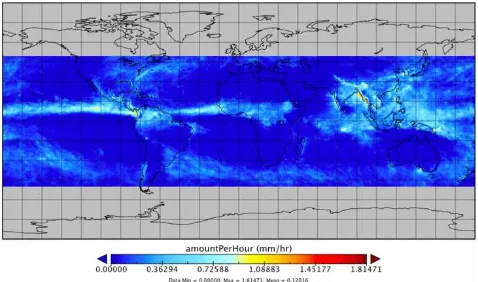
Thus, along with traditional data sources such as census, SEDE is able to provide tweet based population statistics such as total tweets and total users for different spatial
The proposed framework is composed of two parts: data management and data processing as shown in Figure 1. In the data management part, the Lidar data can be directly fetched
The registry API, which is built on top of Solr using Swagger, provides advanced search functionalities to WorldMap: users are able to locate spatio/temporal information using
In order to handle missing values in time series, as well as the lack of considering temporal properties in machine learning models, we propose a spatiotemporal prediction
