isprsarchives XL 5 W2 543 2013
Teks penuh
Gambar
Garis besar
Dokumen terkait
Our goal of the 3D Digital Model Database for wooden construction is to fully demonstrate the earlier wooden constructions information of all aspect that we have collected
International Archives of the Photogrammetry, Remote Sensing and Spatial Information Sciences, Volume XL-5/W2, 2013 XXIV International CIPA Symposium, 2 – 6 September 2013,
The purpose of these tools is to fa- cilitate documentation work in-situ , using data acquired using various sensors (total stations, cameras, laser scanners) and hand measurements
Computer vision researchers have explored many applications to verify the visual accuracy of 3D model but the approaches to verify metric accuracy are few and no one is on
International Archives of the Photogrammetry, Remote Sensing and Spatial Information Sciences, Volume XL-5/W2, 2013 XXIV International CIPA Symposium, 2 – 6 September 2013,
Paper introduces for the first time an overview of a new 3D recording computer tool conceived to support the conservation process for cultural heritages, with
International Archives of the Photogrammetry, Remote Sensing and Spatial Information Sciences, Volume XL-5/W2, 2013 XXIV International CIPA Symposium, 2 – 6 September 2013,
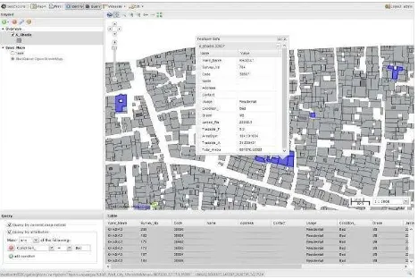
based, and up-to-date land information system containing a record of interests in land (e.g. rights, restrictions and responsibilities). It usually includes a
