isprs archives XLI B1 141 2016
Teks penuh
Gambar

Garis besar
Dokumen terkait
This study evaluated the relative geo-location accuracy of the TerraSAR-X ortho-rectified EEC product by the pixel matching methodology using the pairs of intensity
This algorithm has the following characteristics: using edge point matching results instead of traditional feature point matching to constraint further line matching, which is
Average and extreme residuals in horizontal (dx) vertical (dy) image direction as well the 2D RMSE resulting from template matching between all spectral bands and
Scale, rotation and translation invariance for matching keypoints is critical. In this work we use a wavelet-based descriptor. Our approach comprises of the following
With keeping Sift in mind, this fast matching method is introduced, which uses images exposure time geometry, SIFT point detector and rBRIEF descriptor vector in order to match
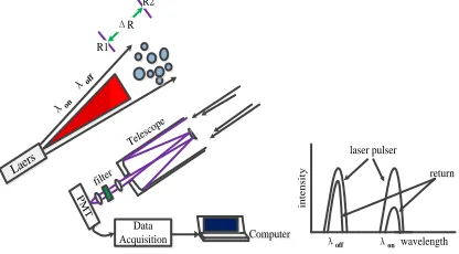
Whereas the system design as a laser profiler exhibits drawbacks compared to scanning systems concerning (i) system calibration due to a lack of redundant strip overlap area and
A mobile laser scanning system has certain components: a Global Navigation Satellite System (GNSS) receiver and inertial measurement unit (IMU), providing platform
Excellent results show that the presented method is better than traditional phase correlation matching methods based on surface fitting in these aspects of accuracy and
