This is Page 1 of the minutes of the regular meeting of Hills Shire Council. A copy of the Controlled Activity Authority to be obtained from the NSW Office of Water must be presented to the Council before a building certificate is issued.
Engineering Works and Design
Minutes of the duly called ordinary meeting of the Hills Shire Council held at the Council Chambers on 9 June 2015. d) Open style fencing must be used. Minutes of the duly called ordinary meeting of the Hills Shire Council held at the Council Chambers on 9th June 2015.
Section 94A Contribution
Any necessary adjustment or relocation of services is also required, as per the requirements of the relevant service authority. Pipelines to each of the proposed new lots, strictly in accordance with the requirements of the relevant service authority, are required.
Traffic Control Plan
All areas within the root protection zone must be covered with composted leaf mulch to a depth of not less than 100 mm. The installation of services within the root protection zone may not be undertaken without prior permission from the Council.
Erection of Signage – Supervision of Work
Trees to be maintained within 10m of any approved subdivision works shall be protected during all works in strict accordance with AS4970- 2009 Protection of Trees in Development Areas.
Contractors Details
Service Authority Consultation – Subdivision Works Before subdivision works commence
Sediment and Erosion Control
Standard of Works
Critical Stage Inspections – Subdivision Works
The production of an information fact sheet (maximum 1 page double-sided) prepared in accordance with the Council's Guidelines for the preparation of Information Fact Sheets (available on the Council's website).
Vegetation Management Plan (VMP) Implementation
Completion of Subdivision Works
Works as Executed Plans
Confirmation of Pipe Locations
Stormwater CCTV Recording
Public Asset Creation Summary
Section 73 Compliance Certificate
Provision of Electrical Services
Provision of Telecommunication Services
Building Services
Performance/ Maintenance Security Bond
Final Plan and 88B Instrument
The minutes of the above meeting were confirmed at the Council meeting on 23 June 2015. The review of the Development Control Plan has been undertaken as part of the Council's initiative to reduce red tape in planning and development.
REVIEW OF INTRODUCTION SECTION
Section 79A(2) of the Act then states that a development application for a specified project (other than the major development types identified above) must be notified or advertised in accordance with the provisions of a development management plan if the development management plan provides for the notice or disclosure of the application. For low-impact telecommunication facilities, given the specific requirements laid down in the provisions of the Telecommunications Act and the industry code, it is proposed not to include such requirements in the plan.
REVIEW OF RURAL DEVELOPMENT CONTROLS
However, in recent times there has been limited interest in rural workers' housing in this Shire. It is therefore proposed that the control measures relating to rural workers' dwellings be deleted from the Development Control Plan and a planning proposal to prohibit rural workers' dwellings in terms of the Local Environment Plan be advanced.
EXTRACT OF CURRENT DEVELOPMENT CONTROL PLAN POLICIES –
The consultation must be proportionate to the expected impact of the facility (Refer to the telecommunications facilities section of The Hills DCP 2012). The Council requires a legible set of plans in A4 size for the purpose of notifying the proposed development.
CONTENTS
- Introduction
- Development Assessment Pathways
- Advertising & Notification Procedures
- Lodging a Development Application
- Ecologically Sustainable Development
- Glossary
- Important Dates & Document Specifications
Development may be required to meet development standards contained in various parts of the Development Control Plan. The design of the development shall comply with the relevant provisions of this Development Control Plan.
INTRODUCTION
GENERAL DEVELOPMENT
- Site Planning
- General Controls applying to rural subdivision STATEMENT OF OUTCOMES
- New Development
- Dwellings
- Rural Sheds
- Tennis Courts
- Agriculture & Rural Industries
- Landscape Material Supplies, Garden Centres &
Restricted land layer development areas should be clear of the restricted land layer shown in Figure 1. Subdivision of rural clusters preserves the scenic and rural character of the Shire and minimizes environmental impacts and fire hazards.
Plant Nurseries
Tourist Facilities, Restaurants & Cafes
Water Storage Facilities (Dams, Weirs, Reservoirs)
Development adjoining or in the visual catchment of the Hawkesbury River
Restricted Development Areas (Kenthurst)
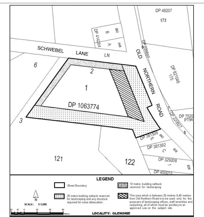
Land at 2 Schwebel Lane, Glenorie
EXTRACTIVE INDUSTRIES
- Transport
- Water Resources
- Visual Amenity & Scenic Quality
- Flora & Fauna Buffer Zones
- Heritage & Archaeological Resources
- Soil Conservation
- Acoustic Management
- Air Quality Management
- Rehabilitation
- Community Engagement
- Setbacks from Maroota Public School
- Section 94 Contributions
- Environmental Management Systems
- Information Required for an Extractive Industries Development Application
The natural, scenic and landscape quality of the area is preserved and the rural character is maintained. The rehabilitation of mining sites is to integrate with the shape, form, contour, vegetation, soil composition, drainage and land use characteristics of the surrounding site. Environmental Management All aspects of the operation are to apply and maintain good environmental management practices.
Details how all facets of the operation will employ and maintain good environmental management practices. Identify principles and objectives of the National Strategy for Ecologically Sustainable Development (ESD) 1992 in relation to the project;. Statistics have been prepared on the operation of the Development Assessment Unit over the past 10 months.
EXCERPT OF CURRENT DELEGATIONS 6. BUILDING
- Grant Development Consent
- Refusal of Applications
- DEVELOPMENT
- Approval of Applications
- Refusal of Applications
- Review of Determination
- Determine Applications under Clause 4.6 of the LEP
- Variations to DCP(s)
- Lots 1307 and 1308 DP 1163493 and Lot 102 DP 1186053 (101, 103 and 104 Edgewater Drive, Kellyville/ Bella Vista)
- Lots 7 and 17 DP 1166676 and Lots 21, 22 and 25 DP 1194623 (50 and 39 Thomas Boulton Circuit, 30 and 19 Water Creek Boulevard and 12 Friesian
To review the decision of an application under the provisions of section 82A of the Environmental Planning & Assessment Act 1979, as amended, other than conformal, integrated or designated development. Approve an amendment to development permits in accordance with Section 96 of the 1979 Planning and Assessment Act, as amended, provided no objections have been received and the proposed amendments are minor in nature. To approve an amendment to development permits outside the provisions of Section 96 of the Environmental Planning and Assessment Act 1979, as amended, provided the application is subject to a report to the Development Assessment Unit.
The applicant, Mulpha Norwest Pty Ltd, is seeking the cancellation of a 2m wide right of way from the title of the three listed properties as it is no longer required. The cancellation of the road level will allow the existing properties to be developed unencumbered for residential purposes. The cancellation of these easements enables the development of the subject properties in accordance with the planning principles, vision and objectives set out in the Community's Strategic Plan.
- Current performance
- Scale and Capacity
- Performance Against Fit For the Future Benchmarks and How Your Council Becomes and Remains Fit For the Future, Along with an Action Plan
- Other Actions Considered
- Performance against the Fit for the Future benchmarks Sustainability Measure/ benchmark2013 / 2014performanceAchieves FFTF benchmark?
- Performance against the Fit for the Future benchmarks Infrastructure and service management Measure/ benchmark2013 /2014performanceAchieves FFTFbenchmark?
- Performance against the Fit for the Future benchmarks Efficiency Measure/ benchmark2013 /2014performanceAchieves FFTFbenchmark?
Hawkesbury City Council is totally opposed to this merger and so is The Hills Shire Council. By any measure (financial, community or business) Hills Shire Council is and will be a top performing council. Hills Shire Council has the technical and managerial expertise to manage responsibly and sustainably.
If the State Government were to agree to Hills Shire Council's proposal, it would:-. The Hills Shire Council rejected the request from Hornsby Shire Council's request for a full amalgamation. Hills Shire Council's Preferred Option will increase the population by 59,220 under the following changes: -.
Hills Shire Council would gain part of Carlingford, Beecroft and Epping (alternatively, if this were incorporated into Parramatta City Council, the net gain from Hornsby City Council would be reduced by approximately 12,692 people with the boundary becoming Pennant Hills Road to Thompsons Corner) . Hills Shire Council meets all Fit for the Future criteria with the exception of the debt service ratio.
REPORT
Efficiency and Effectiveness
The Hills Shire is appropriately resourced and skilled to manage a larger Local
Council’s preferred option
Bus routes 546 and 549 connect Parramatta and Epping on routes through Ray Road,
Hills Shire Council side and Parramatta side. Whereas on the other hand, people leaving
The boundary of the M2 and Windsor Road divides part of the suburb of Baulkham Hills
The Hawkesbury river is then the LGA boundary until Berowra creek to Berowra Waters
Most of these secondary schools are located in the Hills Shire Council area and are connected by public bus transport. The suburb of Wisemans Ferry is currently split between Hornsby and Hills Shire Council boundaries. Incorporating these suburbs into Hills Shire Council further strengthens existing community links that currently do not exist with the Hornsby Shire Council areas.
Dural has developed links by regular public transport and road corridors to areas of the Hills Shire as opposed to the Hornsby Shire areas. Incorporating the suburb of Dural into the Hills Shire Council boundary improves existing community and employment links and also provides the ability to deliver through existing planning expertise the new strategic growth areas of South Dural which will complete important road infrastructure upgrades to the NSW state highways, such as as New Line Rd and Old Northern Rd. The area of South Dural will also benefit from the delivery of the North West railway line which is also mainly located within the Hills Shire Council boundary.
CONCLUSION
RECOMMENDATION
ATTACHMENT 1
- Road Closure & Drainage Easement Income – Increase $7k
- Bus Shelter Income – Increase $98k
- Road Restorations Income – Increase $85k
- Planning Control Income – Increase $412k
- Other Planning Income – Increase $22k
- Fringe Benefits Tax – Decrease $24k
- Storm Damage – Increase $441k
- Transfer to Reserves – Increase $367k
- Transfer from Prior Years Income – $161k
- Increased Net funding for Existing Jobs $28k
- Completed Jobs $130k – Transfer to Capital Works Reserve a) $39,044 Savings in Building Jobs
The proposed Shire boundary stretches from Thompson's Corner in West Pennant Hills south along Pennant Hills Rd to the M2 motorway at Carlingford. The boundary continues through Oakville, McGraths Hill and into the township of Windsor (all from Hawkesbury Council) where it meets the Hawkesbury River. We then follow the Hawkesbury River south from Wisemans Ferry, including the suburbs of Laughtondale, Singleton Mill, Canoelands, Berowra Creek settlement on Berowra Creek waterway, including Fiddletown then Berowra Waters settlement on Berowra Waters waterway, back to Berowra Creek waterway, including Berrilee &.
The purpose of this report, as required by the Local Government Act and related regulations, is to enable the council to review its actual expenditure and income against the adopted budget and to consider changes to the budget. This differs from the budget format, which relates income to the period in which expenditure is expected to occur. Reallocation of 275k to storm water reserve to address storm water backlog from budget surplus generated this month.
Original
All Cash & Investments including Section 94, Trust Fund and unrestricted cash are described in Appendix 1 Page 5. The Council's Chief Financial Officer, as the responsible accountant, announces that the Council's expected financial position is satisfactory. Furthermore, the investments shown in appendix 1 page 5 have been made in accordance with the law, the regulations and the council's actual investment policy.
The proposed budget amendments in Appendix 1, pages 1 to 5 and the amendments described on page 7-22 are adopted. If all other expenditures and revenues are realized in this financial year, it is expected that the Article 94 resources may be greater than. Amounts shown as unlimited cash shown in YTD Actual column are based on income received to date and not all planned expenses have been spent as of this reporting date.
The Hills Shire Council
Project completed, savings returned to capital works reserve Project completed, savings returned to capital works reserve Project completed, savings returned to capital works reserve. Project completed, savings returned to capital works reserve Project completed, savings returned to capital works reserve. Project completed, savings returned to capital works reserve Repair of damaged rip-rap on Strangers Creek rock embankment (near Samantha Riley Dr bike crossing) funded from capital works reserve Reduced internal section design costs 94.
Hills Shire Council Annex 1 PAGE 23 UNLIMITED CHECK REPORT (Fact Based) DEBT SERVICE COMPLETE ANNUAL FEES COVERAGE RATE (Based on Revised Budget) DEBT SERVICE RATES, ANNUAL FEES, TREATMENT AND REWARDS. The Hills Shire Plan which consists of the Hills Future Community Strategic Plan, the Four Year Delivery Program including the Resource Strategy for the Annual Operational Plan containing the Draft Budget and Fees & Charges for the period 1 July 2015 to 30 June 2016. Get In view of the adoption of the Hills Shire Plan 2015/2016, two strategic planning workshops were held in November 2014 and March 2015.