G.,i.
!J.',..
PUSAT PENEI.ITIAN LlNGKUNGAN HIDUP
.. .
CENTER FOR ENVIRONMENTAL RESEARCH
INSTITUT PERTANIAN BOGOR
Working Paper No. 33
December 2011
Landscape Ecology Analysis to Assist Water Requirement Mapping on Upland
Area of Electric MicroHydro InstalaHon (Ciambulawung Watershed), Lebak
Picung, Banten Province
Boedi Tjahjono
Kukuh Murtilaksono
Bambang Hendro Trisasongko
ISSN 20853599
9l
l
ULli
JIUIUl
CENTER FOR ENVIRONMENTAL RESEARCH
Office address: Gedung PPLH 24 Flo, JI. Lingkar Akademik, Kampus IPB Darmaga, Bogor 16680 Mailing address: PO Box 243 Bogor 16001
Tel: +622518621262, 8621085; Fax: +622518622134 Email: pplh[email protected];[email protected]
landscape Ecology Analysis to Assist Water Requirement Mapping on Upland Area of Electric MicroHydro Instalatlon (Ciambulawung Watershed), Lebak Picung, Banten Province
Boedi Tjahono, Kukuh Murtilaksono, Kr'iFnr""'''''' Hendro Trisasongko
Landscape Ecology Analysis to Assist Water Requirement
Mapping on Upland Area of Electric MicroHydro Instalation
(Ciambulawung Watershed), Lebak Picung, Banten Province
Tjahono1),Kukuh MurtilaksonolJ, Bambang Hendro Trisasongko2)
for Environmental
2) SoH Land Bogor
Agricultural University
ABSTRACT
Sustainability in food and enrgy supply has been one of important Indonesia. There have been abundant efforts to obtain such
many Indonesian rural have confronted considerable food and energy sustainability. In many cases, sustainability is difficult due to lacking of data. This include Lebak Picung site although the site is fairly close to many
vvr,,,,,,;,,",,,,,,t in West Java and Banten.
several field substantial datasets were obtained, and land use. These primary along with delivered a first endeavor to study food and on,,,,,,..,,,,
Due to data, assessment of rainfall was made
station, assuming there was no between two sites. Analysis of Bayah data showed that there was divergent rainfall during dry and rainy seasons. This was also concluded in dry season field survey 2011). These variable rainfall records were also with discharge measured in both seasons. We found that Lebak wisely become accustomed to this circumstance by implementing once rice planting season per annum. They also attempt to conserve neighboring forested These
would save enough water from extensive irrigation needs.
By a arithmetic rule, this research endeavored to account water availability in the watershed. Following variables were utilized: rainfall, domestic uses, vegetal water requirements and microhydro water supply. It was inferred that Lebak Picung had a very limited amount of water availability, which may lead to constrained food and energy in dry season. In contrary, there would be no notewortny in wet season or in situation where local inhabitants sustain
rice planting every year. Nonetheless. it was concluded that hydropower seemed exhibit such problems since discharge in dry season was fairly low.
I.
INTRODUCTION
1.1 Background
Sustainability in and one of issues in
developing countries including Indonesia. Previously, many have been made sustainability across the nation. These included expansion and intensification through various ways, such as the SRI (Systems Intensification) (Dobermann, 2004). However, recent
Landscape Ecology Analysis to Assist Water Requirement Mapping on Upland Area of Electric Micro-Hydro Instalation (Ciambulawung Watershed), Lebak Picung, Banten Province
Boedi Tjahono, Kukuh Murtilaksono, Bambang Hendro Trisasongko
shows that problems in energy in Indonesia have become apparent.
Lacking of energy supply from PLN (national state enterprise of electricity) has driven some endeavors to look after alternative energy sources. This includes bioenergy, thermal and solar cells. Bioenergy has been a promising energy source, despite shortage of advance research and industrial challenge. Geothermal energy has been exploited as well, such as of Wayang Windu (Bogie et al. 2008) and KarahaTelaga Bodas (Nemcok et a/., 2007), nonetheless, the capacity has been very small (Lund and Freeston, 2000). Although solar cells could be potential, it requires good energy saving devices and should be optimally operated during daylight.
Another prospective option is water. Some smallscale power generators were established under the Corporate Social Responsibility programs, including the one in Lebak Picung kampong in Lebak, Banten Province. Nonetheless, the installation should be backed by thorough observations on climatic, hydrologic and land use data to ensure continuous, reliable supply of electricity. In addition, there is a need to observe water requirement on various landscape to assist better water management. since there is competing water use between hydropower, domestic use and rice field irrigation. Therefore, a research to address this problem should be performed.
1.2 Purpose
The aims of the research are to assess potentials of stream flow to support various water uses and study strategies of maintaining sustainability of small watershed.
II. METHODOLOGY
2.1 Oatasets
To achieve the goal, several data that were acquired and compiled, includes:
1. Maps: basemaps (topography) and thematic maps (geology, soil, land
system, land use and forest management
2. Satellite imageries: Shuttle Radar Topography Mission (SRTM) Cband
and ALOS AVNIR2
3. Climate: rainfall
4. Hydrology: tributaries and discharge.
2.2 Field Surveys
Landscape Ecology Analysis to Assist Water Requirement Mapping on Upland Area of Electric Micro-Hydro Instalation (Ciambulawung Watershed), Lebak Picung, 8anten Province
Boedi Tjahono, Kukuh Murtilaksono, Bambang Hendro Trisasongko
N
A
1oAAAセAGᄃゥセoセセQ P ゥゥゥゥ o iiiiiiiiiiiiiiiil200 Mete rs Skala 1: 10.000 (Cetak u!vran M)
Sistem Kooron at • PrO';ei<si UfM Zone 48 M . Daum WGS84
N
j
Ii i
r
"
. &i セ@ iセ@^@ セ@ t
=
F====:::::!lJ
i
]]]]セ]ゥ ャ ] G@
=====
. _.,
il_
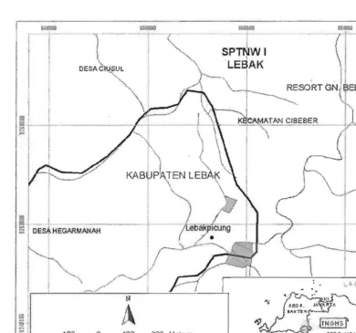
Figure 1 . Location of Study
2.3 Data Analysis
Updated land use information is one of primary data required in this research. The data were mainly constructed through visual image interpretation of ALOS AVNIR2 imagery acquired in 2009. In order to fill gaps due to cloud cover, the research also exploited Google Earth dataset, again using visual interpretation. Primary interpretation keys to discriminate various land covers were tone, texture, association, and shape.
Prior visual interpretation, remotely sensed data were preprocessed using national base maps (BAKOSURTANAL's Rupa Bumi Indonesia). Geometric correction of remote sensing data requires a set of tie points which were visually identifiable both in the field and in visual appearance. To align the image according to the base map, bilinear interpolation was used. This interpolation technique is a compromise between pOSitional accuracy while subsequently maintains image properties, such as tone and texture.
To assist spatial analysis, additional thematic datasets such as forest management and thematic maps were also collected. Some information, including slope, were extracted from digital elevation model. There are some
[image:4.611.79.469.102.467.2]Landscape Ecology Analysis to Assist Water Requirement Mapping on Upland Area of Electric Micro-Hydro Instalation (Ciambulawung Watershed), Lebak Picung, Banten Province
Boedi Tjahono, Kukuh Murtilaksono, Bambang Hendro Trisasongko
sources of digital elevalion model: (a) topographic maps at scale of 1:25,000; (b) SRTM; and (c) ASTER GDEM. To avoid misjudgment in proper DEM selection, a preliminary observation was constructed. The result was presented in a seminar [ProceedingsGeoSARNas, 2011).
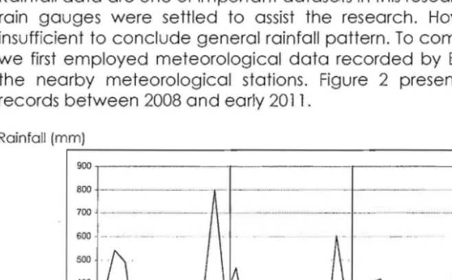
Rainfall data were problematic since there is no meteorological station nearby the research area. To obtain the data, 5 conventional rainfall gauges were established in the Ciambulawung watershed [Figure 2). The gauges were visited daily to obtain dailybasis rainfall data on the test site.
Discharge data were obtained during 2 field surveys, i.e. in wet and dry seasons, using current meter. To obtain minimum discharge related to rainfall intensity and land use, this research employed water balance equation as follows:
Water Strorage/Supply = R WRref DU HP where:
R = Rainfall
WRref = Water requirement of rice and forest DU = Domestic water used
HP = Hydropower requirement.
III. RESULT AND DISCUSSION
3.1 Rainfall Data
Rainfall data are one of important datasets in this research. Five conventional rain gauges were settled to assist the research. However, the data are insufficient to conclude general rainfall pattern. To comprehend the pattern, we first employed meteorological data recorded by Bayah Station, one of the nearby meteorological stations. Figure 2 presents fluctuating rainfall records between 2008 and early 2011.
Rainfall (mm)
r---,
800
9oo . - - -- - - -- - -r - - r - - -
---r--.... -- ---
MM セ MM
..--...
セセ ZM]M
...
セM]@
セ j@
700 600I
I
I
500 400 300 200 I 1000 '"' '" r- oo g
... g
'" 0セ@
8
... g
\'l 0 Nセ@
...
"':il 0 :il 0 0
セ@
00 <; セ@ 0
\'l
g
'" .,セ@
00セ@
0セ@ g 0 0 0
セ@ 0
0 セ@ セ@ セ@ セ
セ@ 0 セ@ 0 0 0 0 0 0
N N N N N N N N N N
[image:5.611.102.431.497.701.2]Date
Figure 2. Rainfall data [Bayah Station)
Landscape Ecology Analysis to Assist Water Requirement Mapping on Upland Area of Electric Micro-Hydro Instalation (Ciambulawung Watershed), Lebak Picung, Banten Province
Boedi Tjahono, Kukuh Murtilaksono, Bambang Hendro Trisasongko
It appears that Southern Banten region has about 45 months of dry season with monthly rainfall records nearly zero. In the 2010, effects of La Nina as reported by Australian Government Bureau of Meteorology (BOM, 2011) are clearly seen in the figure. First semester of 2011 seems following original condition of 2008. Based on Bayah the data, 20082010 yearly average could be computed easily. We obtained 3,253
mm
of yearly average rainfall.3.2 Discharge
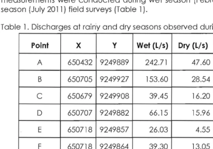
[image:6.611.99.449.256.501.2]In order to observe actual flows of Ciambulawung river, two direct measurements were conducted during wet season (February 2011) and dry season (July 2011) field surveys {Table 1).
Table 1. Discharges at rainy and dry seasons observed during field surveys
Point X Y Wet (Lis) Dry (Lis) Deficit (Lis)
A 650432 9249889 242.71 47.60 195.11
B 650705 9249927 153.60 28.54 125.06
C 650679 9249908 39.45 16.20 23 .25
D 650707 9249882 66.15 15.96 50.19
E 650718 9249857 26 .03 4.55 21.48
F 650718 9249864 39.30 13.05 26.25
G 650685 9249945 118.23 51.38 66.85
H 650671 9250043 206.10 35.21 170.89
I 650671 9250045 112.38 49.25 63.13
Point A (outlet. hydropower site) is located within the main course of the Ciambulawung river. It has highest discharge during rainy seasons.
ャ|ャッョ・エィセャ・ウウL@ the table also indicates that substantial deficit was seen in the
outlet. Field survey on July 2011 pointed out that water deficit on the turbine was fairly severe, and local inhabitants experienced many blackouts during the dry season.
3.3 Land Use
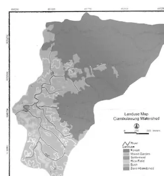
ALOS A VNIR2 and Google Earth images were employed for land use mapping (Figure 3). Field visit to verify satellitederived land use information was taken in February 2011 and successfully acquired 50 point observations. Acreage of each land use class is presented in Table 2.
Landscape Ecology Analysis to Assist Water Requirement Mapping on Upland Area of Electric MicroHydro Instalation (Clambulawung Watershed), Lebak Plcung, Banten Province
Boedi Tjahono, Kukuh Murtilaksono, Bambang Hendro Trisasongko
land use Map
Clamllula;.; ng W<ltershed
i|OrN L@ セ ᆳ
セセ A_@ セ イLイ ᄋ MZN@ Bエ@
'.' eo G. tfQen
Seih mCRl
. FH>lu
b\NZDセ@
セ s。 BMセ L@ a「 ゥャャ ョ 」ZI@ セ エ BHI@
[image:7.611.107.432.117.465.2]Figure 3. Land use map.
Table 2. Land use classes in Ciambulawung sub watershed
Land use class Total (ha)
Forest 326.57
Mixed Garden 155.67
Settlement 1.65
Rice Field 26.52
Bush 42.62
Barel
Abandoned 2.02Total 555 .05
Landscape Ecology Analysis to Assist Water Requirement Mapping on Upland Area of Electric Micro-Hydro Instalation (Ciambulawung Watershed), Lebak Picung, Banten Province
Boedi Tjahono, Kukuh Murtilaksono, Bambang Hendro Trisasongko
3.4 Water Availability
In this research, water availability was computed using following arithmetic operation:
Water Strorage/Supply = R WRref DU HP
where:
R = Rainfall
WRref = Water requirement of rice and forest DU = Domestic water used
HP = Hydropower requirement.
Yearly average rainfall data was computed in Section 3.1., that is 3,253 mm.
Water loss by means of evapotranspiration was accounted by only considering two major land use types: forest and rice fields . Specifically for rice fields, we used Arsyad's findings, i.e. 4.09 mm/day (for dry season) and 5.08 mm/day (for wet season). These values were then extrapolated into yearly basis using following assumptions: 4 months (once rice planting season per annum).
WateUoss_rice = (5.08 mm/day x 30 days x 4 months) = 609 .6 mm.
Water loss by forest was estimated using Ciwulan watershed (Onrizal, 2005) mentioning the fact that Ciambulawung watershed is also dominated by forest.
WateUoss_forest = 109.0 mm/month x 12 months = 1308 mm.
Therefore, estimated water loss by evapotranspiration is 1917.6 mm.
To compute domestic water use, this research employed general water requirement by a household as described in Triatmojo (2008) i.e. 82.5 L/person/day. Assuming Lebak Picung population was still 54 households and each household had 4 members, estimated water required by all population is 17,820 L/day or about 6,504,300 L p.a or 65043 x 108 mm3 p.a. Again
assuming these value was required by solely settlement areas (1.65 ha), it was eslimated that domestic requirement of water is :
65043xl08
165xl08
which leads to 394.2 mm. Compared to estimated rainfall, domestic use water requirement is fairly small (about 12%).
In this research, we used an approximation from previous work by Sudargana et al. (2005) which estimated suitable discharge for Lebak Picung microhydro turbine (10 KVA) at 0.1274 m3/sec or 4017686.4 m3/year. Water requirement for microhydro turbine was then computed using division by watershed acreage (555.05 hal and resulted 723.8 mm.
Landscape Ecology Analysis to Assist Water Requirement Mapping on Upland Area of Electric Micro-Hydro Instalation (Ciambulawung Watershed), Lebak Picung, Banten Province
Boedi Tjahono, Kukuh Murtilaksono, Bambang Hendro Trisasongko
Considering above variables, overall water availability on annual basis was
Water_Availability
=
3,253.9 mm -1917.6 mm - 394.2 mm - 723.8 mm =217.3mmThis suggests that availability of water to support daily living and continuous supply of energy through hydropower has been sufficient. except during dry season when the river discharge is very small and it is not sufficient at all for the hydroelectric generation. However, the research also found that variability between dry and wet seasons has been high. Therefore, future research should account computation based on each season as an aid to identify critical months in dry season.
IV. CONCLUSION
Securities in food and energy have been substantial to many nations policy, including Indonesia. Numerous efforts were or being implemented to assist such achievements. However, in many remote parts of Indonesia, food and energy sustainability is a real challenge. In some cases, assessing food and energy sustainability is problematic due to unavailable or insufficient data. Lebak Picung site has been experiencing similar problem as well.
Through numerous field visits, important datasets have been captured. This included rainfall, discharge and land use. These primary data, along with secondary information, provided a first attempt to study food and energy sustainability in Lebak Picung site. Due to insufficient rainfall data, assessment of rainfall was made possible using Bayah meteorological station, assuming there was no significant biases between two sites . It was expected that there was contrasting rainfall during dry and rainy seasons. This was confirmed by field survey in dry season (July 2011). These fluctuating rainfall were also reflected in comparison of discharge measured in both seasons. Lebak Picung inhabitants wisely adapt to this situation through once rice planting season per annum and attempt to preserve forested landscape. This would save enough water from extensive irrigation needs.
Employir)g simple arithmetic rule, this research attempted to account water availability ゥョセィ・@ site. Following variables were exploited: rainfall, domestic uses, vegetal water requirements and microhydro water supply. It was concluded that Lebak Picung had a small amount of water availability, which may lead to イ・ウセイゥ」エ・、@ sustainability for both food and energy . There would be no significant problems in wet season or if local inhabitants maintain once rice season every year. A greater problem lies in hydropower sustainability since discharge in dry season seemed fairly low.
Landscape Ecology Analysis to Assist water Requirement Mapping on Upland Area of Electric MicroHydro Instalation (Ciambulawung Watershed), Lebak Picung, Banten Province
Boedi Tjahono, Kukuh Murtilaksono, Bambang Hendro Trisasongko
ACKNOWLEDGEMENT
The authors would like thank Osaka Foundation International (OGFICE) Japan for funding research and our students
and Reyna) for assistance during field surveys.
REFERENCES
Arnold, J.G. & Fohrer, N. . SWAT2000: current and research opportunities in applied watershed modeling. Hydrological Processes, 19, 563572.
Huggins, L.F. & Monke. E.J. (1980). ANSWERS: a model for watershed planning. Transactions of the ASABE. 938-944.
Bogie. I.. Y.I. & M.e. (2008). Overview of the Wayang Windu geothermal field. West Indonesia. 37.347365.
J .. Park. S. & 1m. S. (2008). Evaluation of Agricultural Nonpoint Source (AGNPSJ model for small watersheds in Korea applying cell delineation.
Agricultural Water Management, 95. 40()"408.
Dobermann. A. (2004). A critical assessment of the of rice intensification (SRI).
Agricultural Systems. 79. 261281
A.F.M .. Sathyamoorthy. D. & V.S. 1). A method for computation of surface of digital elevation model terrains via multiscale
37,177192.
Lee. S. . Soil erosion assessment and its verification the Universal Soil Loss and Information a case study at Boun. Korea.
Environmental Geology. 45.457465.
Lund, J.W. & D.H. (2000). Worldwide direct uses of geothermal energy 2000.
Proceedings of World Geothermal KyushuTohoku, Japan, 28 May 10 June 2000.
Makrakis. 5 .• Gomes, L.C .. Makrakis, M.C., D.R. & e.S. (2007). The Canal da Piracema at Itaipu Dam as a fish pass system. Neotropical Ichthyology. 5. 185195.
M .. Moore. J.N" (20'07). Controls on the
36,946.
Allis. R.. 1.. Murray. B. & Nash. G. Bodas geothermal reservoir. Indonesia.
Onrizal. (2005). Hutan dan pengaturan toto air. Jurusan Kehutanan. Universitas Sumatera Utara.
Othman, N .. Jafri. Lim. H.S. & K.e. (201l). Using ASTER GDEM and SRTM digital elevation models to contour lines over rugged terrain of Makkah. 2011 IEEE International Conference on Science and Communication. Article no. 6015842, pp. 1113.
Prasannakumar, V .. Shinny, R., N. & H. (2011). prediction of soil erosion risk remote GIS and RUSLE approach: a case study of Siruvani river watershed in valley. Kerala. India. Environmental Earth Science. DOl 10.1007 /s 126650 1109133.
Landscape Ecology Analysis to Assist Water Requirement Mapping on Upland Area of Electric Micro-Hydro Instalation (Ciambulawung Watershed), Lebak Picung, Santen Province
Boedi Tjahono, Kukuh Murtilaksono, Bambang Hendro Trisasongko
Rosatto, H.G., TolonBecerra, A., Botta, G. & Presutti, M.E. (2011). Runoff estimation in small rural watersheds using OEMS in North West of Argentina. Soil and Tillage Research, 112,817.
Sudargana, Karnoto & Nugroho, H. (2005). Studi kelayakan dan prancangan pembangkit listrik tenaga mikrohidro di Dukuh Pekuluran, Kec. Doro, Kab. Pelcalongan. Rotasi, 7, 15,
Triatmojo, B. (2008). Hidrologi terapan. Beta Offset.
Wang, L Perissin, 0., Rocca, F. & Liao, MS. (2011). Three Gorges Dam stability monitoring with time series InSAR image analysis. Science Chino Earth Sciences,
54, 720732.
Smith, L.C. (2002). Emerging applications of interferometric synthetic aperture radar (InSAR) in geomorphology and hydrology. Annals of the Association of