LAHARS IN JAVA: INITIATIONS, DYNAMICS, HAZARD ASSESSMENT AND DEPOSITION PROCESSES
Franck Lavigne 1,3 , Jean-Claude Thouret 2, Danang Sri Hadmoko 1,3, C. Bambang Sukatja 4
1 Laboratoire de Géographie Physique, UMR 8591, CNRS, Meudon, France. E-mail : [email protected]
2 Laboratoire Magmas et Volcans, OPGC, Université Blaise Pascal et CNRS, Clermont-Ferrand, France; Email : [email protected] 3 Research Centre for Disasters, Gadjah Mada University, Bulaksumur C-16,
Yogyakarta, Indonesia. Email : [email protected] 4 Balai Sabo, Sopalan, Maguwoharjo, Yogyakarta.
E-mail : [email protected]
ABSTRACT
L
ahar has been applied as a general term for rapidly flowing, high-concentration, poorly sorted sediment-laden mixtures of rock debris and water (other than normal streamflow) from a volcano. Lahars are one of the most destructive phenomena associated with composite volcanoes, which are dominant in Java Island. Resulting deposits of lahar are poorly sorted, massive, made up of clasts (chiefly of volcanic composition), that generally include a mud-poor matrix. The aim of this research is threefold: to discuss the initiation of lahars occurrences, their dynamics, to assess the hazard and to analyse the deposition. Lahars are either a direct result of eruptive activity or not temporally related to eruptions. Syn-eruptive lahars may result from the transformation on pyroclastic flows or debris avalanches which transform to aqueous flows (e.g. at Papandayan in November 2002); They may be also generated through lake outburst or breaching (e.g. at Kelut in 1909 or 1966), and through removal of pyroclastic debris by subsequent heavy rainstorms. Post-eruptive lahar occurs during several years after an eruption. At Merapi, lahars are commonly rain-triggered by rainfalls having an average intensity of about 40 mm in 2 hours. Most occur during the rainy season from November to April. Non-eruptive lahars are flows generated without eruptive activity, particularly in the case of a debris avalanche or a lake outburst (e.g., Kelut). A lahar may include one or more discrete flow processes and encompass a variety of rheological flow types and flow transformations. As such, lahars encompass a continuum between debris flows and hyperconcentrated flows, as observed at Merapi, Kelut and Semeru volcanoes. Debris flows, with water contents ranging from 10 to no more than about 25% weight, are non-newtonian fluids that move as fairly coherent masses in what is thought to be predominantly laminar fashion. However, the relative importance of laminar versus turbulent regime is still debatable. Hyperconcentrated streamflows contain 25- to about 40%-weight-water; these flows possess some yield stress, but they are characteristically turbulent. Hazard-zone maps for lahar were produced for most of the the Javanese volcanoes, but these maps are on too small-scale to meet modern zoning requirements. More recently, a few large-scale maps (1/10,000 and 1/2,000-scale) and risk assessments have been completed for a few critical river systems at Merapi.Key-words: lahar, lahar deposit, hazard, flow behaviour, deposition, rheology.
INTRODUCTION
Lahar is a Javanese term that means a rapidly flowing, high concentration, poorly sorted sediment-laden mixture of rock
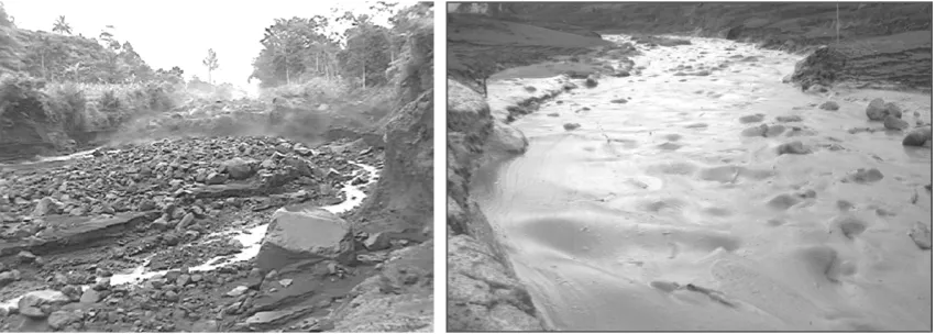
debris flow is a non-newtonian fluid with a sediment concentration ³ 60% volume or 80% weight (Smith and Lowe, 1991: Figure 1a). A hyperconcentrated streamflow has a lower sediment concentration which ranges from 20 to 60% volume (Vallance, 2000, Lavigne and Thouret, 2000). A mudflow is a cohesive, relatively fine-rich flow (Figure 1b), whose behaviour and sediment concen-tration (20-40%) are quite distinct (see dis-cussion in Coussot and Meunier, 1996).
Because lahars are water saturated, both liquid and solid interactions determine their unique behaviour and distinguish them from other related phenomena com-mon to volcanoes such as debris avalanches and floods. Rock fragments make lahars among the most destructive phenomena associated with composite volcanoes in Java; abundant liquid contained in them allows them to flow over gentle gradients and inundate areas far away from their sources. Between the 17th and 19th century, lahars were responsible for 17% of the people loss due to volcanic eruptions, es-sentially in Indonesia. During the 20th cen-tury, lahars took a toll of 31,500 victims,
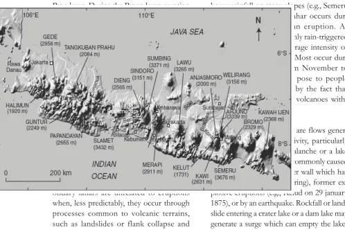
owing to two deadly disasters at Kelud (1919) in Java (Figure 2) and Nevado del Ruiz (1985) in Colombia. In 1909, post-eruptive lahars from Mt Semeru have had already seriously damaged the city of Lumajang.
The aims of this research are to dis-cuss the initiation of lahars occurrences, their dynamics, to assess the hazard and to analyse the deposition processes at differ-ent volcanoes in Java. We used four volca-noes as representative examples of Javan volcanoes i.e. Merapi, Semeru, Papandayan and Kelud because their activities are rela-tively more dynamic compared than others.
[image:2.595.86.512.84.236.2]Lahars can be produced in several ways. Primary lahars are syn-eruptive, that is deriving from pyroclastic flows and surges churning and melting snow and ice or gen-erated by a crater lake expulsion during eruptions (e.g., Kelud in 1919, Galunggung in 1822; Figure 2). Most syn-eruptive la-hars are generated when a drainage system is choked by a pyroclastic flow, a ‘wet’ py-roclastic surge or a debris avalanche, as examplified during the 2002’ eruption of
Figure 1. Difference between non-cohesive debris flow at Semeru, East Java in January 2002 (left), and cohesive debris flow (mudflow) at Papandayan,
Papadayan. During the Papandayan eruption in November 2002, repeated volcanic earth-quakes, induced by a series of phreatic and phreatomagmatic explosions, triggered three main landslides on the caldera rim. One of the landslides was rapidly transformed into a debris avalanche, having a volume of 1.7 x 10⁶ m3. Moving outside the caldera rim, this debris avalanche entered a series of three landslide-dammed lakes and released a large volume of water to the River Cibeureum. The mixture of water and sediment generated a primary lahar that destroyed 245 houses.
The majority of lahars are secondary and post-eruptive, i.e. triggered by rainfall on loose pyroclastic material (e.g., Merapi in 1984 and 1994). Yet another set of sec-ondary lahars are unrelated to eruptions when, less predictably, they occur through processes common to volcanic terrains, such as landslides or flank collapse and
heavy rainfall on steep slopes (e.g., Semeru in 1981). Post-eruptive lahar occurs dur-ing several years after an eruption. At Merapi, lahars are commonly rain-triggered by rainfalls having an average intensity of about 40 mm in 2 hours. Most occur dur-ing the rainy season from November to April. Hazards that they pose to people and goods are enhanced by the fact that they can be triggered on volcanoes with-out any eruption.
[image:3.595.8.507.414.746.2]METHODS
This paper is based on some research projects conducted by authors during sev-eral years on four Javan Volcanoes such as Merapi, Semeru, Papandayan and Kelud. We combined several methods such as sec-ondary data analysis, field investigations, field instrumentations of channels at Merapi and Merbabu.
Lahars initiation and rainfall thresh-olds were analysed by correlate the minutely rainfall data and lahars occurrences from installed automatic rain gauges and Acous-tic Flow Meters (AFM). We assessed the sediment concentration through repeated direct sampling. A heavy-duty plastic con-tainer was tossed into the flow at the end of a rope from the left river bank of the channel. The sampler was sunk into the lahar using a bamboo pole. Samples were transferred into a 10 l-graduated bucket, and the volume of sediment was measured af-ter a 24-h period of deposition. Lahar dy-namic can also be monitored by using novel instrumentation, such as video and cinema-tography with wire or ground-vibration trig-gers, ultrasonic (non-contact) water level recorders, various telemetry systems, and sampling devices for muddy water and de-bris. Acoustic Flow Monitors (AFM) and Real-time Seismic Amplitude Measurement (RSAM) were used in this work. Sedimen-tary facies analysis has been conducted by visual interpretation in the field on several slope profiles across the channels and com-pleted by using grain size in laboratory.
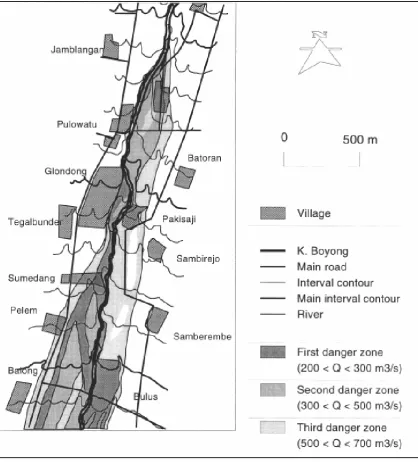
Hazard assessment was conducted by using geomorphological investigations in order to delineate the lahar-prone areas on the SW flank of Merapi and the SE flank of Semeru volcanoes, and to produce six
hazard 1/10,000 and 1/2000 scale maps for highly populated areas, such as the pe-rimeter of Yogyakarta (Lavigne et al., 2000a; Figure 10). Micro-zonation was based on lahar scenarios in which four dis-charge categories correspond to four lahar-prone areas (area 1= d”200 m3/s, area 2= 200-300 m3/s, area 3= 300-500 m3/s, and area 4= 500-700 m3/s). The method en-compasses: location, frequency, and scale of the past lahar events; measurements of the channel geometry, riverbed gradient, and degree of meandering in relation to possible lahar overflows, calculation of mean velocity, calculation of maximum flow discharge per section, and location of probable overflow points, based on empiri-cal models for discharge assessment. Fi-nally, risk assessment and maps were per-formed, based on enquiries to assess vul-nerability and the cost of potential loss.
RESULT AND DISCUSSION
Initiation: Rainfall Intensities and Du-ration
Lahar genesis requires: (1) an adequate water source; (2) abundant unconsolidated debris that typically includes pyroclastic-flow and -fall deposits, colluvium, soil, etc., (3) steep slopes and substantial relief at the source; and (4) a triggering mechanism. Water sources include pore or hydrothermal water, rapidly melted snow and ice, subgla-cially trapped water, crater or lake water, and rainfall runoff (Vallance, 2000).
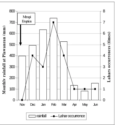
commonly trigger lahars, mostly from No-vember to April (Figure 3). Actual trigger-ing-rainfall intensity can vary widely, due to such factors as rainfall duration and per-meability of pyroclastic deposits. Rainfall thresholds for triggering lahars are not simi-lar on volcanoes even if they are located in one climatic area, and can vary on one single edifice, because topography, windward side, and elevation exert an influence on advec-tion and convecadvec-tion of air masses, hence on subsequent distribution of rainfall. In
addition, the rainfall thresholds increase with time after an eruption, and depend on the geographical origin of rain-generating air masses with respect to the volcano sides.
At Merapi, two types of triggering rainfalls are commonly distinguished: local, stationary or orographic rainfall confined to slopes above 1200 m in elevation, and re-gional, migratory rainfall, that is transported from the NW or the SW. The lahars gener-ated by stationary rainfalls are all small- or
0
100
200
300
400
500
600
700
800
Nov Dec Jan Feb Mar Apr May Jun
0
1
2
3
4
5
6
7
8
[image:5.595.103.488.80.495.2]rainfall
Lahar occurrence
Merapi EruptionM
o
n
thl
y
r
a
in
fa
ll
a
t Pl
aw
a
n
ga
n
(mm
)
L
a
h
a
rs
o
ccu
rrence
s
(t
im
e
s)
medium-scale debris flows (80,000 m3 of sediment deposits), whereas all the large-scale debris flows (> 80,000 m3 of depos-its) are generated by migratory rainfalls (Lavigne et al., 2000a). The influence of ground saturation prior to a rain event can also be substantial: a critical parameter is the ‘working rainfall”, defined as total rainfall that precedes the lahar event for 7 days. The VSTC defined the correlation between work-ing rainfall and 1-h rainfall for lahar initia-tion in the Putih River. The data distribu-tion suggests the critical reladistribu-tionship as y = 54 - 0.22x (Lavigne et al., 2000a).
Lahar Dynamics and Hydraulic Char-acteristics
Lahar velocity, discharge, and transport capacity are much higher than
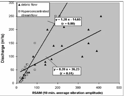
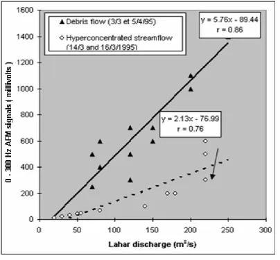
that of normal streamflows. The velocities range between 2.5 and 6 m/s on a slope of 4% (Merapi, 1994), and as much as 11 m/ s on steep slopes (Kelud, 1990). Since 1980, all the rivers prone to lahars at Merapi have been dammed by Sabo dams, which slow down the lahars. Frontal mean velocity of debris flows in the Boyong River in 1994-1995 ranged from 2.7 to 3.6 m/s on slope of 6.6 %. The peak flow velocity is greater than the average velocity of the flow front: 5-7 m/s to 11 m/s in 1934 and in 1984, and as much as 15 m/s at Kaliurang on 20 May 1995. The maximum peak flow velocity is observed 1 to 5 minutes after passage of the flow front. The examples of measurement results of AFM and SSAM can be presented at Figure 4 and Figure 5 respectively.
Figure 5. Data recorded by SSAM for lahar monitoring system at Kaliurang (Lavigne, et al, 2000b)
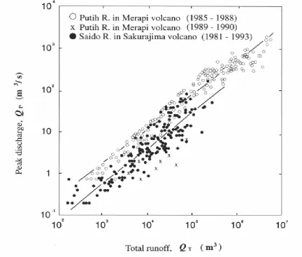
[image:7.595.70.503.307.674.2]The discharge of lahars is calculated by multiplying the cross-section area by the mean flow velocity. At Merapi, recorded peak discharges (Qp) range in magnitude from about 1 to about 2000 m3/s in the Putih drainage in 1985-1990. The corre-sponding total runoff (Qt) in lahars and flood event ranges from about 500 to 5 million m3 (Figure 6). A linear correlation links peak discharge and total runoff, with the regression as follows: Qp=0.00558Qt
0.831
(r= 0.977) (Figure 5). Maximum dis-charge per unit drainage area is 131 m3/s/ km2 close to values recorded at Sakurajima, Japan (165 m3/s/km2). For small-scale la-hars in the Boyong River in 1994-95, peak discharges ranged from 50 to 360 m3/s, and runoffs varied from 7 x 10⁴ to 5 x 10⁵ m3.
Lahars in Java are usually character-ized by only one or two main pulses, but may have three events lasting 2 h or more. Lahars at Merapi are short-period events related to short-period rainfall (commonly 1 or 2 h). The lahar flow duration recorded in 1994-95 in the Boyong River at Kaliurang, 8 km from the vent, ranged from 30 min to 2 h 30 min. A lahar can show a succession of debris flows phases, hyperconcentrated flow phases, and some-times transient streamflow phases. Pulsing of the flows may result from the variation of intensity during a storm, variable distri-bution of rainfall over the drainage basin, arrival of an additional lahar surge initiated in tributary, inherent flow instability, and natural self-damming and rapid release.
[image:8.595.101.499.83.392.2]formation on sediment concentration is necessary to discriminate between the dif-ferent flow types, such as debris flows and hyperconcentrated flows. Quantitative data on sediment concentration is provided by the AFM system at Merapi. The ratio be-tween the low and high acoustic frequency signal strength can yield a rough estimation of the flow concentration. Preliminary re-sults obtained by AFM data processing and visual observations show that flow beha-viour can change very rapidly over a few kilometres.
Non-contact detection instrumenta-tion was installed on the slopes of Merapi
during the first rainy season following the nuées ardentes of 22 November 1994 (Lavigne et al., 2000b; Lavigne and Thouret, 2002). These devices include RSAM, SSAM and AFM systems. Calibra-tion of the various systems was accom-plished by field measurements of flow ve-locities and discharge, contemporaneously with instrumental monitoring (Figs. 7 and 8). More than 50 lahars were generated around Merapi during the first rainy season following the 1994 nuées ardentes. They were relatively short events in the Boyong River, commonly ranging between 30 min and 1 h 30 min. Almost 90% of the lahars were recognized at Kaliurang village
[image:9.595.96.501.349.724.2]tween 13:00 and 17:30 h, due to the pre-dominance of afternoon rainfalls (Figure 5). The observed mean velocity of lahar fronts ranged between 1.1 and 3.4 m/s, whereas the peak velocity of the flows var-ied from 11 to 15 m/s at Kaliurang. Peak discharges recorded in various events ranged from 33 to 360 m3/s.
Flow behaviour
At Kelud, at least 33 post-eruption lahars followed the 10 February 1990 plinian eruption and deposited as much as 30 x 106 m3 (Thouret et al., 1998). Subtle but significant sedimentologic differences in the deposits relate to four flow types. A) Early, massive deposits are coarse, poorly sorted, slightly cohesive, and commonly inversely graded. They are inferred to record hot lahars that incorporated pumice and scoria from pyroclastic-flow deposits, probably by rapid remobilisation of hot proximal pyroclastic-flow deposits by rain-fall runoff. Sedimentary features, such as clasts subparallel to bedding and thick, in-versely to ungraded beds, suggest that these flows were laminar. B) Abundant, very poorly sorted deposits include non-cohe-sive, clast-supported, inversely graded beds and ungraded, finer-grained, and cohesive matrix-supported beds. These beds display layering and vertical segregation/density stratification, suggesting unsteady proper-ties of pulsing debris flows. They are inter-preted as deposited from segments of flow waves at a middle distance downstream that incorporated pre-eruption sediments. Sedimentologic evidence suggests unsteady flow properties during progressive aggra-dation. C) Fine-grained, poorly sorted and ungraded deposits are interpreted as record-ing late hyperconcentrated flows that formed in the waning stage of an overflow and transfor med downvalley into
streamflows. D) Ungraded, crudely strati-fied deposits were emplaced by flows tran-sitional between hyperconcentrated flows and streamflows that travelled further down valley as far as 27 km from the vent.
Owing to abrupt initiation, flow in-stabilities, and particle segregation pro-cesses, lahars contrast with water floods in at least three ways: the flow behaviour is unsteady and non-uniform, the capacity of sediment transport is exceptional, and the effects on valley channels are severe, com-monly exceeding the effects from non-vol-canic debris flows. Past work on lahar me-chanics used models based on the Bagnold or the Bingham theories. Recent work em-phasizes that lahar consist of mixture of solids and fluids, which have mechanical properties distinct from either solids or flu-ids in isolation. Recent advances in theory and experimentation show that a lahar moves as a surge or a series of surges, driven by gravity, by porosity fluctuation, and by pore fluid pressures, in accordance with the Coulomb grain flow model. Grain size dis-tribution and sorting control pore pressure
distribution (Iverson, 1997).
Processes of deposition are complex and poorly known. Interpretation of mas-sive and unsorted lahar deposits commonly ascribe the deposition regime to a freezing process. However, recent laboratory experi-ments have highlighted that debris flows deposits may result from incremental depo-sition processes (Major, 1997). The bound-ary between debris flows, hyperconcen-trated flows and transitional flows may act and fluctuate within the flow itself. Sev-eral parameters play a role on this bound-ary: grain size distribution, physical and chemical composition of sediments, shear stress, and yield stress (Iverson, 1997). Therefore, caution should be applied when transport processes and lahar behaviour are inferred from the deposit thickness and the maximum clast size.
[image:11.595.88.513.432.679.2]
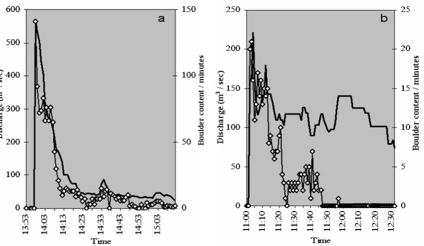
Figure 9. Time changes in the lahar discharge (black line) and the content of large boulder particles (white dots). (a) 19 January 2002 debris flow.
Hazard assessment in lahar-prone areas
Rock fragments make lahars among the most destructive phenomena associated with composite volcanoes; abundant liquid contained in them allows them to flow over gentle gradients and inundate areas far away from their sources (e.g., 400 km2 around Mt
Pinatubo and 286 km2 in area around
Merapi; Vallance, 2000; Rodolfo, 2000). The total elements at risk in the K. Boyong/ Code valley escalate to as much as 100 million US dollars (Lavigne et al., 2000).
[image:12.595.89.508.240.703.2]Along the Code river, 144 ha are prone to lahar or flood hazard within area 3 (300–500 m3/s), and 674 ha are threat-ened within area 4 (500–700 m3/s). About
13,000 people live at risk along the river, where population density exceeds 5,600/ km2 (Figure 10). Population growth is 2% a year, partly due to urban migration from the Merapi countryside. The approximate value of likely loss for the upper level of hazard is 52 - 106 US $, mainly due to the high density of houses.
Sediment erosion and transportation processes, and budget
Lahar is one of the strongest erosive agents worldwide following a major erup-tion. Lahars remove deposits on volcano slopes and in channels at variable rates that depend partly on the volume of newly erupted pyroclastic debris, which is on the eruption magnitude. The lower the erup-tion magnitude, the quicker the removal of pyroclastic deposits, e.g., spanning one year after the small-scale 1994 eruption at Merapi but exceeding 10 years after the large-scale 1991 eruption at Pinatubo. Sedi-ment yields reached 106 m3 per km2 during the first post-eruption year at Pinatubo, nearly one order of magnitude greater than the maximum sediment yield following the 1980 eruption of Mt St. Helens. Large vol-umes of lahar deposits in excess of 107 m3
(Mt St. Helens, Pinatubo) result from the bulking capacity of primary lahars which scour and incorporate most of the material from former deposits that mantle valley slopes and channels. On volcanoes devoid of glaciers, as in Indonesia, lahars com-monly flow shorter distances downvalley in the range of a few tens of kilometres.
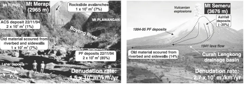
[image:13.595.87.516.550.698.2]Sediment yields on volcanic slopes that are covered by fine-grained tephra com-monly range from 104 to 105 m3/km2/yr (Major, 2000). Annual sediment yield at Merapi and Semeru are among this range. At Merapi, a volume of about 2.5 x 10⁶ m3 of pyroclastic-flow deposits were emplaced in the upper reaches of the Boyong, Bedog and Bebeng Rivers in 1994 (Figure 10.). Based on the volume of the lahar sediments that were trapped by the five new check dams during the first rain season following the 22 November 1994 eruption at Merapi, an annual rate of sediment yield of 1.5 x 10⁵ m3/km2 was calculated in the Boyong river catchments (Lavigne et al., 2000a; Lavigne and Thouret, 2002; Lavigne, 2002; Figure 11). At Semeru, sediment discharges were assessed from direct measurements on the lahars in motion.
In the Lengkong River, the rate of sediment yield in the year 2000 was esti-mated at 2.7 x 10⁵ m3/km2. In both cases, the efficiency of the erosion does not re-sult from a large volume of pyroclastic de-posits following each eruption, but is a con-sequence of the yearly return period of the lahars. Daily vulcanian/strombolian explo-sions at Semeru provide a more continu-ous and volumincontinu-ous sediment supply than dome avalanching at Merapi. But the mag-nitude of lahars decreases exponentially since the last effective eruption, and cor-responding sediment yields decrease in a similar fashion. The decline of lahars is mainly caused by progressive loss of source pyroclastic debris, by the improvement in infiltration, and decrease in runoff on hillslopes previously mantled with tephra but rapidly covered with vegetation.
Sedimentary Facies
A wide range of facies may be gen-erated from a single flow, which may trans-form downvalley from debris flow to hyperconcentrated flow. Non-cohesive de-bris flows (<5% clay/sand+silt+clay) and (or) grain flows commonly display such a trend. In contrast, mudflows and (or) co-hesive debris flows (>5% clay/sand+ silt+clay) show no significant change downvalley (Scott, 1988; Scott and Vallance, 1997. A lahar deposit commonly forms one massive bed or a succession of stratified beds, either normally graded or inversely graded; toward the base, some beds show a thin, texturally fine-grained zone termed sole layer. Lahar deposits are poorly sorted, massive, and made up of clasts (chiefly of volcanic composition) that generally include a mud-poor matrix. At Merapi, textures are typically sandy gravel or gravely sand, because the source mate-rial is coarse block-and-ash debris from
‘Merapi-type’ pyroclastic flows. The debris flow deposits are commonly non cohesive, except in the Woro channel, due to the hy-drothermal material source in the Woro solfatara field. Proportions of vitric, crys-tal, and lithic components of the lahar de-posits help to discriminate the type of ju-venile pyroclasts that feed the lahars and the amount of incorporated non-juvenile material. At Papandayan, West Java, lahar materials are usually cohesive and domi-nated by the silt and clay materials.
CONCLUSIONS
Lahars encompass debris flows, hyperconcentrated flows, and transitional flows. The triggering of secondary lahars depends firstly on rainfall intensity and sec-ondly on the duration of rainfall and ‘work-ing rainfalls’. Lahars are usually character-ized by one or two main pulses, but may have more events lasting 2 hours or more. Data of Real-time Seismic Amplitude Mea-surement and Acoustic Flow Monitoring systems were correlated with instantaneous flow velocities and discharges measured in the field at Merapi.
Interpretation of massive and unsorted lahar deposits commonly ascribe the deposi-tion regime to a freezing en masse process. However, recent laboratory experiments have highlighted that debris flows deposits may result from incremental deposition processes. Owing to abrupt initiation, flow instabilities, and particle segregation processes, lahars con-trast with water floods in at least three ways: the flow behaviour is unsteady and non-uni-form, the capacity of sediment transport is exceptional, and the effects on valley chan-nels are severe. Recent advances in theory and experimentation show that a lahar moves as a surge or a series of surges, driven by
grav-ity, by porosity fluctuation, and by pore fluid pressures, in accordance with the Coulomb grain flow model.
ACKNOWLEDGEMENT
We are indebted to the French Min-istry of Foreign Affairs, the French Em-bassy in Jakarta, and the French Delega-tion aux Risques Majeurs (DRM) for finan-cial support during fieldworks and some other missions of Lavigne. We also would like to acknowledge to anonymous review-ers for their constructive reviews of this manuscript.
REFERENCES
Coussot, P., and Meunier, M., 1996. Recognition, classification and mechanical description of debris flows. Earth-Science Reviews, 40, pp. 209-227.
Iverson R.M., 1997. The physics of debris flows. Review of Geophysics, 35, 3, pp. 245-296.
Jitousono, T., Shimokawa, E., Tsuchiya, S., Haryanto, Djamal, H., 1995. Debris flow following the 1984 eruption with pyroclastic flows in Merapi volcano, Indonesia. In: Proc. Workshop on Erosion Control through Volcanic Hydrological Approach (WECVHA), Sabo Technical Center, Yogyakarta, 10–11 January, pp. 131–149.
Lavigne, F., 2004. Rate of sediment yield following small-scale volcanic eruptions - A quantitative assessment at the Merapi and Semeru stratovolcanoes, Java, Indonesia.
Earth Surf. Process. Landforms 29, pp. 1045–1058.
Lavigne, F., Thouret, J.-C., 2000. Les lahars, dépôts, occurrence et dynamique : une revue des écoulements volcano-hydrologiques. Bulletin Société géologique de France, 171, 5, 545-558.
Lavigne, F., Thouret, J.-C., 2002. Sediment transportation and deposition by rain-triggered lahars at Merapi volcano, Central Java, Indonesia. Geomorphology (accepted October 2001, in the press).
Lavigne F., Thouret J.-C., and Suwa H., 2000a. Lahars at Merapi volcano, Central Java: an overview. J. Volcanology and Geothermal Research, Special issue Merapi Volcano, Java, 100, 423-456.
Major, J.J., 1997. Depositional processes in large-scale debris-flow experiments. J. of Geology, 105, 345-366.
Major, J.J., Pierson, T.C., Dinehart, R.L., Costa, J.E., 2000. Sediment yield following severe disturbance—A two decade perspective from Mount St. Helens. Geology, 28, 9, 819-822.
Priyana, Y. 2004. “Potensi Lahan untuk Ternak Sapi Perah di Lereng Timur Gunbungapi Merapi-Merbabu Kabupaten Boyolali, Jawa Tengah”. Forum Geografi, Vol. 18, No. 2, Desember 2004. Hlm 173-183.
Rodolfo, K., 2000. The hazard from lahars and jökulhaups. In: Sigurdsson, H. et al., eds., 2000: Encyclopedia of volcanoes. San Diego: Academic Press, p. 973-995.
Rodolfo, K.S., Arguden, A.T.,1991. Rain-lahar generation and sediment-delivery systems at Mayon volcano. In: Fisher, R.V., Smith, G.A., eds., Sedimentation in volcanic settings. SEPM, Special Publication 45, 71-87.
Scott, KM., 1988. Origins, behavior, and sedimentology of lahars and lahar-runout flows in the Toutle-Cowlitz River system. U.S. Geological Survey Professional Paper 1447-A, 74 p.
Scott, K.M., Vallance, J.W., 1997. The Osceola mudflow from Mount Rainier: sedimentology and hazard implications of a huge clay-rich debris flow. Geological Society of America Bulletin, 109, 143-163.
Smith G.A., Lowe D.R., 1991. Lahars: volcano-hydrologic events and deposition in the debris flow-hyperconcentrated flow continuum. In: R.V. Fisher, G.A. Smith, eds.,
Sedimentation in volcanic settings. SEPM Special Publication 45, pp. 59-70.
Thouret J.-C., Abdurachman K. E., Bourdier J.-L., and Bronto S., 1998. Origin, characteristics, and behaviour of subsequent lahars of the 1990 eruption at Kelud, East Java (Indonesia). Bulletin of Volcanology, 1998, 59, 460-480.
Thouret J.-C., Lavigne F., 2000.: Lahars: occurrence, deposits and behaviour of volcano-hydrologic flows. In: Leyrit H. and Montenat C., eds., Volcaniclastic rocks from magmas to sediments. Gordon and Breach Science Publishers, chapter 8, pp. 151-174.
Vallance, J.W., 2000. Lahars. In: Sigurdsson, H. et al., eds., 2000: Encyclopaedia of volcanoes. San Diego: Academic Press, p. 601-616.